Minneapolis/St. Paul Urban Partnership Agreement
Minneapolis-St. Paul-Area Urban Partnership Agreement
Additional Information
Minnesota Urban Partnership Agreement Test Plans
- National Evaluation: Content Analysis Test Plan (HTML, PDF 779KB)
- National Evaluation: Exogenous Factors Test Plan (HTML, PDF 1.8MB)
- National Evaluation: Cost Benefit Analysis Test Plan (HTML, PDF 1.1MB)
- National Evaluation: Surveys, Interviews, and Focus Groups Test Plan (HTML, PDF 3MB)
- National Evaluation: Telecommuting Test Plan (HTML, PDF 1MB)
- National Evaluation: Traffic System Data Test Plan (HTML, PDF 1.6MB)
- National Evaluation: Safety Data Test Plan (HTML, PDF 1MB)
- National Evaluation: Tolling Test Plan (HTML, PDF 226KB)
- National Evaluation: Transit System Test Plan (HTML, PDF 1.8MB)
Priced, Managed Lane Network with Peak-Period Transit Discounts
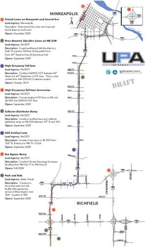
The Twin Cities Metropolitan Area, encompassing Minneapolis and St. Paul, converted narrow bus-only shoulder lanes along the northbound portion of Interstate 35W between 46th Street and downtown Minneapolis to wider priced dynamic shoulder lanes (PDSL), and moved the lanes from the right-most to the left-most portion of the roadway to minimize conflict with entering vehicles. Buses and high-occupancy vehicles operate at no charge in the PDSLs with access allowed during peak times to single-occupant vehicles whose drivers are willing to pay the toll, with prices set to ensure free-flow travel. PDSLs enable bus speeds to increase to 50 mph from the current bus-only shoulder lane speeds of 35 mph or less. In the longer term, the goal is to convert as many miles as possible of Minnesota's existing 260-mile bus-only shoulder lane network to PDSLs.

Minneapolis Project Map 1. Select map for a larger view.

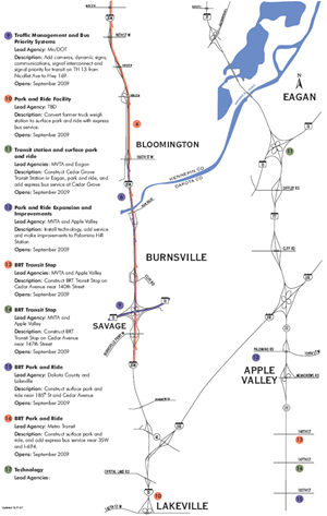
Minneapolis Project Map 2. Select map for a larger view.
The PDSLs link up with new, dynamically-priced high-occupancy toll (HOT) lanes on Interstate I-35W, created by converting the existing high-occupancy vehicle (HOV) lanes which extend from approximately I-494 to the Burnsville Parkway, and also to HOT lanes extended through the Crosstown Commons between I-494 and 46th Street. This created a new 15-mile, dynamically-priced managed-lane corridor, speeding bus and HOV trips, and also provides motorists a new option to experience a fast and reliable trip. This is an especially important corridor, as it connects downtown Minneapolis with multiple communities to the south, and provides access to the Bloomington Strip, Mall of America, Minneapolis/St. Paul International Airport, and the University of Minnesota.
To create and manage the PDSLs, the Minnesota Department of Transportation uses many advanced technologies. To ensure proper and safe lane usage, dynamic lane assignment technology— including LED arrows, in-pavement markings, and the like—direct motorists precisely to the appropriate sections of the roadway. A novel University of Minnesota system provides direct feedback to bus drivers using shoulder lanes. New dynamic message signs and some of the existing dynamic message signs inform travelers about the availability of the lanes for non-bus use, toll rates when the lanes are available, travel speeds on the priced lanes versus on the general-purpose lanes, and also transit alternatives (i.e., park-and-ride) to driving on the priced lanes. Electronic signage also provides substantial information about arterial travel alternatives to freeways for drivers trying to avoid priced freeways and to bypass incidences.
Other Supporting Urban Partnership Elements
In and around the affected I-35W corridor, substantially enhanced transit services and a bus rapid transit (BRT) network were created. Additional transit vehicles were purchased, the single contra-flow bus lane in downtown Minneapolis on Marquette and 2nd Avenue was converted to dual lanes (and new bus shelters and other amenities will be provided), new BRT stations were built, a bus ramp at an important interchange (TH-62 and TH-77) was added, priority for transit vehicles at signalized intersections was implemented, and electronic signs at stations project bus arrival times based upon real-time data. For travelers accessing transit by car, 1,400 additional park-and-ride spaces were created and new electronic signage was deployed indicating current space availability and parking alternatives. The dual contra-flow bus lanes in downtown Minneapolis improved bus throughput over the single lane and reduced bus travel times for the 665 express buses now entering downtown Minneapolis during the morning commute period, as well as for the additional buses purchased under the Urban Partnership Agreement that serve downtown.
The Regional Transportation Management Center deploys various technologies and oversees a host of efforts to improve highway operations in the I-35W / TH-77 corridor. These improvements include improved traffic signal operations, enhanced real-time traffic monitoring and traveler information.
The final element of the Minnesota Urban Partnership Agreement is telecommuting. This locally-funded effort focused on expanding upon the successful Results-Only Work Environment (ROWE) program, where employers agree to evaluate employee results, in lieu of requiring physical presence at the worksite at specific times, and provide employees the flexibility to telecommute or shift their hours to avoid congested commutes. Approximately 75 percent of Best Buy's 4,500 corporate office employees participate in ROWE. Large employers in the priced corridor (the overall region is home to 20 Fortune 500 companies and 33 Fortune 1000 companies) were targeted for participation, with the goal of reducing 500 daily peak-period trips through the corridor.
You may need the Adobe Acrobat Reader to view the PDFs on this page.
