San Francisco-Oakland Bay Bridge East Span Seismic Safety Project
Transportation Management Plan
Printable Version (PDF 13.16 MB)
You will need the Adobe Reader to view this PDF.
Contact Information: WorkZoneFeedback@dot.gov
Slide 1. San Francisco-Oakland Bay Bridge East Span Seismic Safety Project
Transportation Management Plan
For WTI Phase I YBI Viaduct Demolition and Replacement
![]()
Slide 2. Presentation Outline
- Project Description
- Construction Activities
- Transportation Changes
- Transportation Management Plan (TMP) Strategies
- Post-Evaluation Study
Slide 3. Project Description
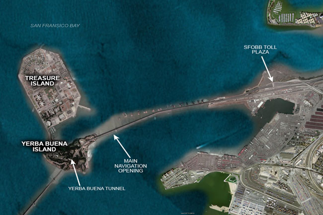
Slide 4. San Francisco-Oakland Bay Bridge East Span Seismic Safety Project Overview
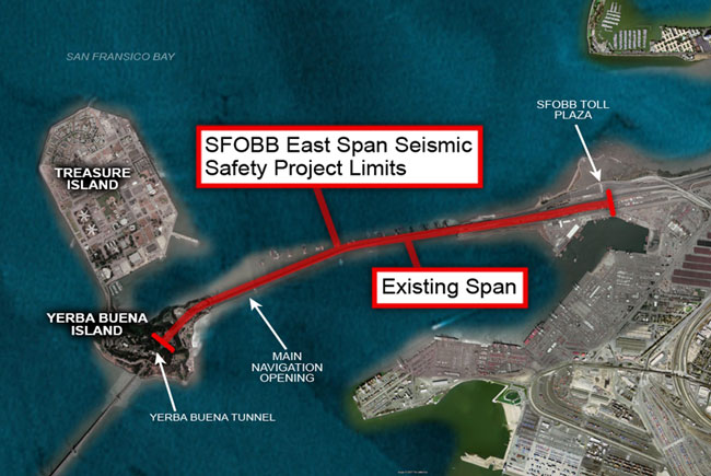
Slide 5. SFOBB East Span Seismic Safety Project Limits and Existing Span
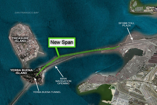
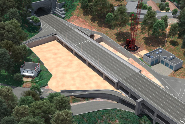
Slide 6. New Span
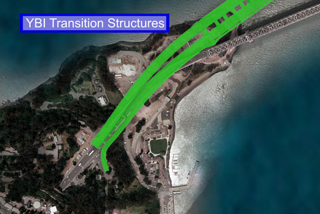
Slide 7. YBI Transition Structures
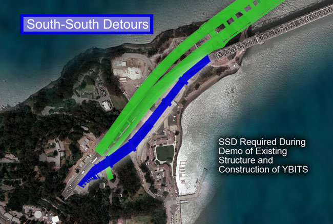
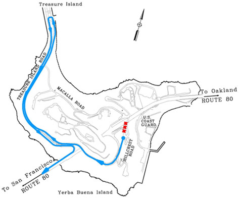
Slide 8. South-South Detours
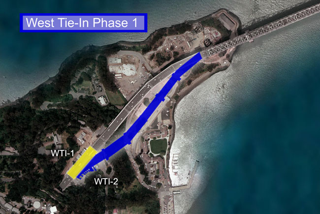
Slide 9. West Tie-In Phase 1
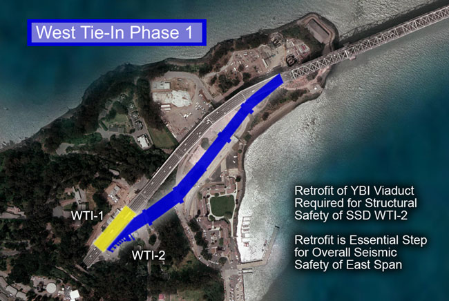
Slide 10. West Tie-In Phase 1
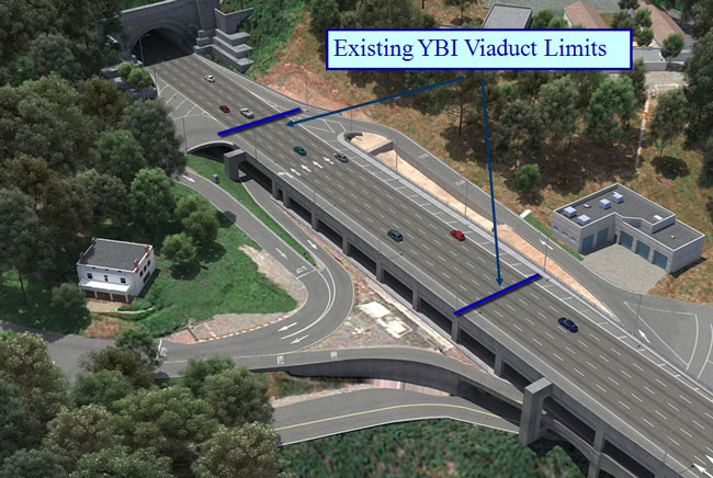
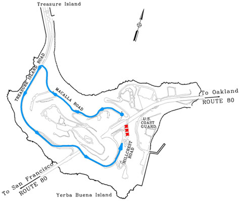
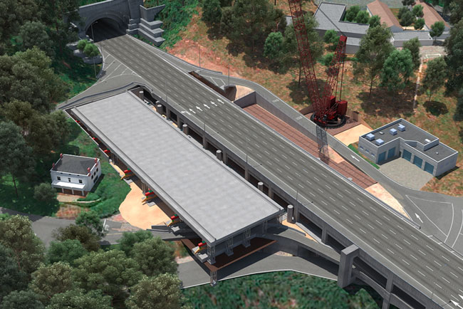
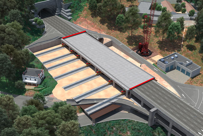
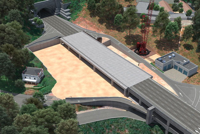
Slide 11. Existing YBI Viaduct Limits
Slide 12. YBI Viaduct Retrofit
- Retrofit by Replacement of Structure
- Design, Constructability, and Seismic Safety
- Advantages
- Construction Period
- January to September 2007
- FULL BRIDGE CLOSURE REQUIRED
- LABOR DAY WEEKEND 2007
Slide 13. Local Traffic Changes on YBI
Beginning January 2007
Slide 14. YBI Ramp and Local Road Closures
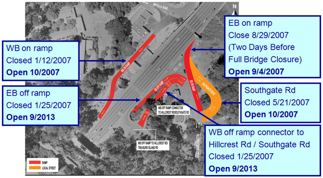
Slide 15. Local Traffic Detour Westbound On Ramp
Slide 16. Local Traffic Detour Eastbound Off Ramp
Slide 17. Local Traffic Detour Westbound Off Ramp Connector to Hillcrest Road
Slide 18. Local Traffic Detour Southgate Road
Slide 19. Local Traffic Detour Eastbound On Ramp
Slide 20. Local Traffic Detour Eastbound On Ramp (Continued)
Slide 21. Local Transit Changes
- MUNI 108 Bus
- Continued service on West Span
- New route
- Use on/off ramps on west side of YBI
- YBI via shuttle service (between Treasure Island Main Gate, Macalla Road, and USCG Station Gate)
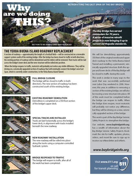
Slide 22. Construction Activities
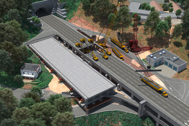
Demolition and Replacement (Labor Day Weekend 2007)
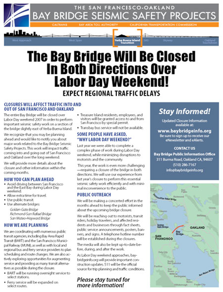
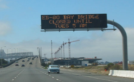
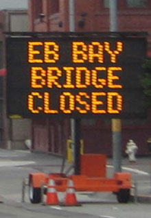
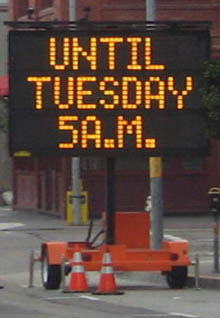
Slide 23. 81-HOUR FULL BRIDGE CLOSURE
FRI 8/31/07 8 PM to TUE 9/4/07 5 AM
Slide 24. Full Bridge Closure
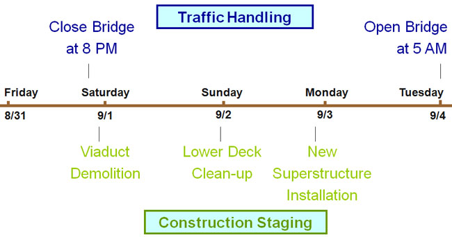
Slide 25. 08/31/07 8 PM – Bay Bridge Closure
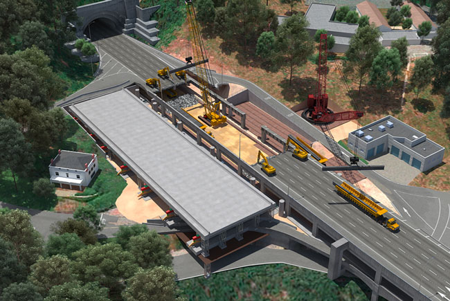
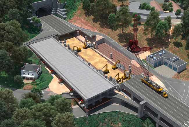
Slide 26. Existing Viaduct Dismantling Step 0

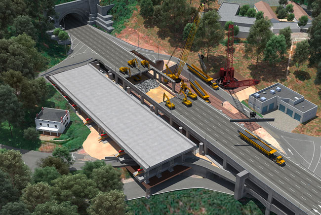
Slide 27. Existing Viaduct Dismantling Step 1
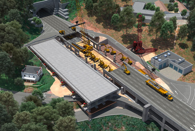
Slide 28. Existing Viaduct Dismantling Step 2
Slide 29. Existing Viaduct Dismantling Step 3
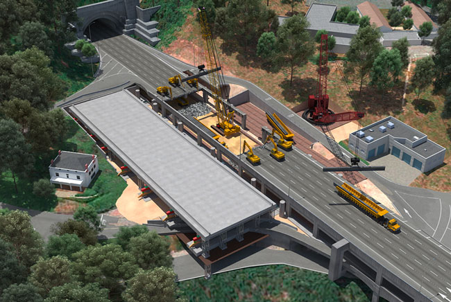
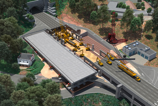
Slide 30. Existing Viaduct Dismantling Step 4
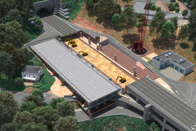
Slide 31. Existing Viaduct Dismantling Step 5
Slide 32. Existing Viaduct Dismantling Step 6
Slide 33. Existing Viaduct Dismantling Step 7
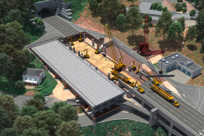
Slide 34. Existing Viaduct Dismantling Step 8
Slide 35. Existing Viaduct Dismantling Step 9
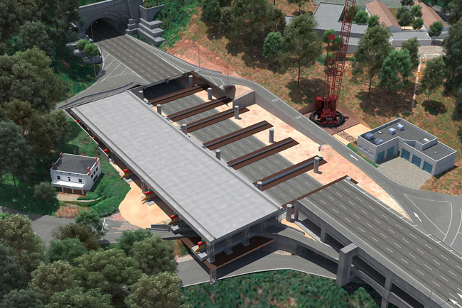
Slide 36. Existing Viaduct Dismantling Step 10

Slide 37. Remaining Moving Apparatus Installation
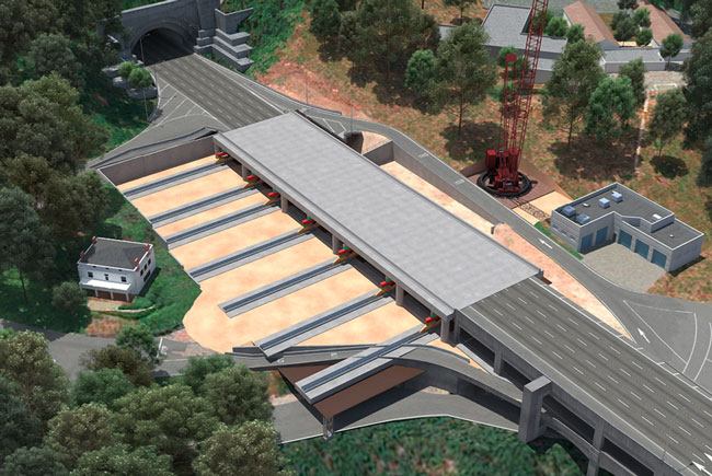
Slide 38. New Viaduct Installation
Slide 39. Joints Construction
Slide 40. Moving Apparatus Removal
Slide 41. 09/04/07 5 AM – Bay Bridge Re-Opening
Slide 42. 09/04/07 5 AM – Bay Bridge Re-Opening

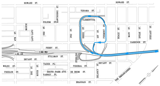
Slide 43. Regional and Local Traffic Changes
FULL BRIDGE CLOSURE Labor Day Weekend 2007
Slide 44. Regional Traffic Detours
Slide 45. Bay Area-wide Westbound Traffic Detours
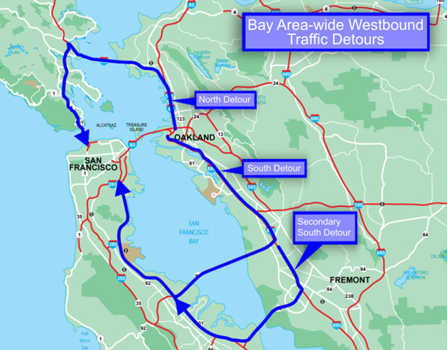
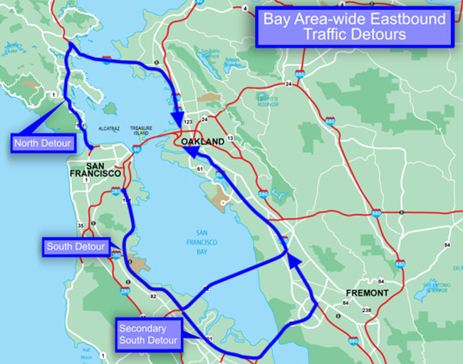
Slide 46. Bay Area-wide Eastbound Traffic Detours
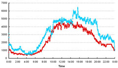
Slide 47. Regional Traffic Conditions
Slide 48. Regional Traffic Conditions
- Traffic diversion patterns observed in the eastbound direction during the Labor Day Weekend 2006 Bay Bridge eastbound closure, are expected to occur during the Labor Day Weekend 2007
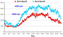
Slide 49. FLow Rates: NB 101 @ Golden Gate Bridge, Labor Day Weekend, Saturday 2005 vs 2006
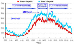
Slide 50. FLow Rates: NB 101 @ Golden Gate Bridge, Labor Day Weekend, Sunday 2005 vs 2006, EB Bay Bridge Closed
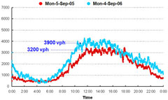
Slide 51. FLow Rates: NB 101 @ Golden Gate Bridge, Labor Day Weekend, Monday 2005 vs 2006, EB Bay Bridge Closed
Slide 52. FLow Rates: EB 92 @ San Mateo-Hayward Bridge, Labor Day Weekend, Saturday 2005 vs 2006, EB Bay Bridge Closed
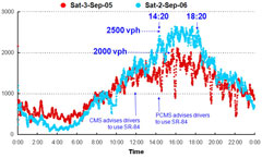
Slide 53. FLow Rates: EB 84 @ Dumbarton Bridge, Labor Day Weekend, Saturday 2005 vs 2006, EB Bay Bridge Closed
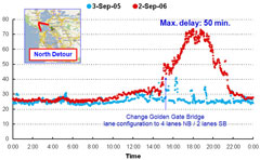
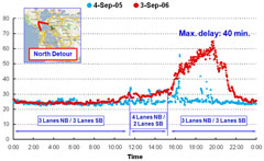
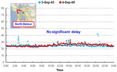
Slide 54. North Detour Travel Time, Saturday 2005 vs 2006, EB Bay Bridge Closed
Slide 55. North Detour Travel Time, Sunday 2005 vs 2006, EB Bay Bridge Closed
Slide 56. North Detour Travel Time, Monday 2005 vs 2006, EB Bay Bridge Closed
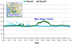
Slide 57. South Detour Travel Time, Saturday 2005 vs 2006, EB Bay Bridge Closed
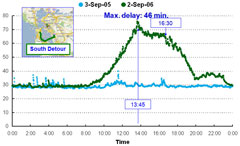
Slide 58. South Detour Travel Time, Sunday 2005 vs 2006, EB Bay Bridge Closed
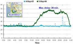
Slide 59. South Detour Travel Time, Monday 2005 vs 2006, EB Bay Bridge Closed
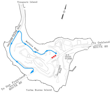
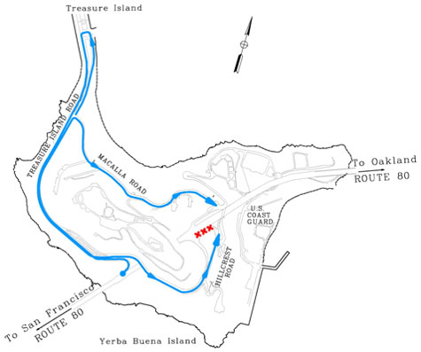
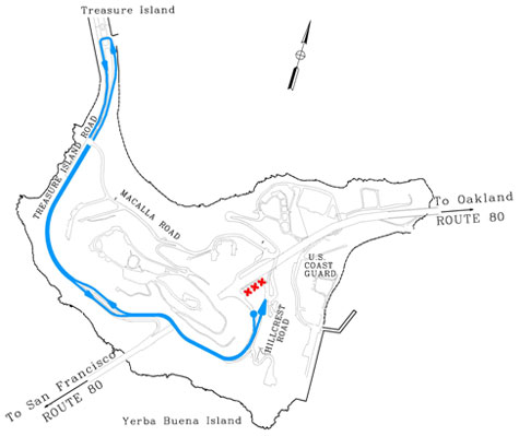
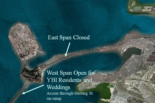
Slide 60. Maintaining YBI Access
- Between YBI and San Francisco via Bay Bridge West Span
- Between YBI and East Bay via San Francisco and Regional Traffic Detours or BART
Slide 61. Maintaining YBI Access
Slide 62. Transbay Transit Changes
- Additional Services
- BART and Ferry (more information in the TMP Strategies – Demand Management section)
- MUNI 108 bus on regular weekday schedule, with YBI shuttle service
- Cancelled Services
- AC Transit transbay trips
Slide 63. Transportation Management Plan (TMP) Strategies
FULL BRIDGE CLOSURE Labor Day Weekend 2007
Slide 64. TMP Strategies
- Public Information
- Motorist Information
- Transportation Management
- Construction Strategies
- Demand Management
- Alternate Route Strategies
Slide 65. Public Information
Slide 66. Public Information
- Outreach Sequence
- Key Stakeholders
- Elected Officials
- Media
- Public
Slide 67. Key Stakeholders Outreach (Beginning March 2007)
- Key Stakeholders
- County Transportation Authorities
- City and County of San Francisco (CCSF)
- City of Oakland
- Treasure Island Development Authority (TIDA)
- Cities of Hayward, Marin, Larkspur, San Rafael
- Golden Gate Bridge
- Major Professional Sport Teams
- Oakland Art and Soul Festival
Slide 68. Elected Officials Outreach (Beginning April 2007)
- Two Outreach Meetings
- Invitations to the offices of Senators, all members of the Bay Area Congressional delegation, all Bay Area state Senators, all Assembly members from the Bay Area, Supervisors in all nine Bay Area counties, mayors in key Bay Area cities
- E-Alerts
Slide 69. Fact Sheet Sample
Slide 70. Fact Sheet Sample (Continued)
Slide 71. Media Outreach (Beginning April 2007)
- Media Outreach Sessions
- San Francisco-Oakland Bay Area
- Sacramento-San Joaquin Area
- Southern California as requested
- Press Releases
- Two weeks in advance
- At completion of closure
- Public Information Officer Live Update
- One week in advance
- During Labor Day closure
- After completion of closure
Slide 72. State-wide Public Outreach (Beginning April 2007)
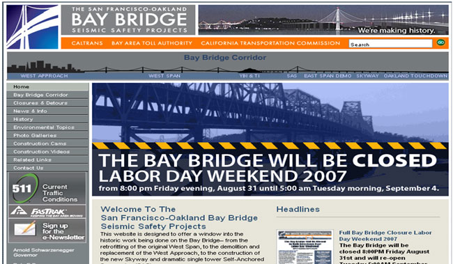
- Community Meetings
- Website
- Mailers and Flyers
- Banners
- Local Notification
- Telephone Hotline
- E-Alerts
- Public Service Announcements
- Out-of-Town Traveler Notification
- Transit Agency Coordination
- MTC 511 Coordination
- Information Letter to Caltrans Employees
- Coordination with Other Caltrans Districts
Slide 73. Community Meetings
- Oakland / East Bay
- Chambers of Commerce
- Event arenas
- Emergency services
- Hotel, Bar and Restaurant Associations
- Port of Oakland
- City of Oakland Event Planning Commission
- Hospital HR
- San Francisco
- Chambers of Commerce
- Event arenas
- Emergency services
- Hotel, Bar and Restaurant Associations
- SF Businesses at the Piers
- SF Businesses
- City of San Francisco Event Planning Commission
- Hospital HR
Slide 74. Community Meetings
- Airports
- Oakland International
- San Francisco International
- Mineta San Jose International
- Sacramento International and Sonoma County
- Treasure Island
- TIDA Board of Directors meetings
- Monthly Treasure Island Community meetings
- Monthly Job Corps
- Key Businesses
- Genetech of South San Francisco
- ATT & SBC
- Charles Schwab
- One Market
- Equity Office
- Boston Properties
- Delivery, Mail, and Trucking Services
- Other agencies as needed
Slide 75. Project Website
Slide 76. Mailers and Flyers
- Greater Emphasis on East Bay than in Previous Eastbound Only Closure
- Distribution to
- Local / corridor businesses
- Neighborhood newsletters and other publications
- TIDA and Mayor's Office staff
- Residential neighbors, including Treasure Island / YBI residents
Slide 77. Mailers and Flyers
- Distribution to (Continued)
- Taxis and shuttle services, airports, hotels, car rental agencies, visitor's bureaus, the State Tourism Office, Chambers of Commerce and automobile associations
- Hospitals, major employers, funeral homes, farmers markets, carpool centers, parking garages, shopping malls
Slide 78. Mailers and Flyers
- Distribution to (Continued)
- Major regional and local entertainment and sports venues
- Cities from San Luis Obispo to Sacramento in the target areas
- Ferry, bus transit, and rail operators, transit centers, BART, the Water Transit Authority, and the San Francisco Metropolitan Transportation Agency
Slide 79. Mailers and Flyers
- Distribution to (Continued)
- State and local offices of the California tourism agencies and convention bureaus
- Approximately 5,000 organizations and private citizens on the Bay Bridge Public Information Office contact list
Slide 80. Transit Agency Coordination
- BART
- Muni
- AC Transit
- Caltrain
- Samtrans
- Golden Gate Transit
- Vallejo Ferry
- Alameda / Oakland Ferry
- Greyhound
- Amtrak
- Airport Shuttle Service
Slide 81. Motorist Information
Slide 82. Traveler Information
- Changeable Message Signs (CMS's)
- Highway Advisory Radio (HAR)
- Two weeks in advance
- During full bridge closure: Real-time modification based on traffic conditions
Slide 83. Traveler Information
- 511 Services for Real-Time Traveler Information
- Updated Transit Information
Slide 84. Changeable Message Signs
- Regional Deployment
- Fixed and portable CMS in San-Francisco-Oakland Bay Area (District 4) and neighboring Districts (1, 3, 5, 10)
- Local Deployment
- Portable CMS on surface streets in various Cities
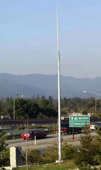
Slide 85. Fixed CMS, Portable CMS
Fixed CMS
Portable CMS
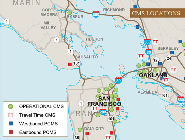
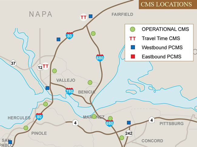
Slide 86. CMS Locations
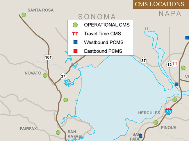
Slide 87. CMS Locations
Slide 88. CMS Locations
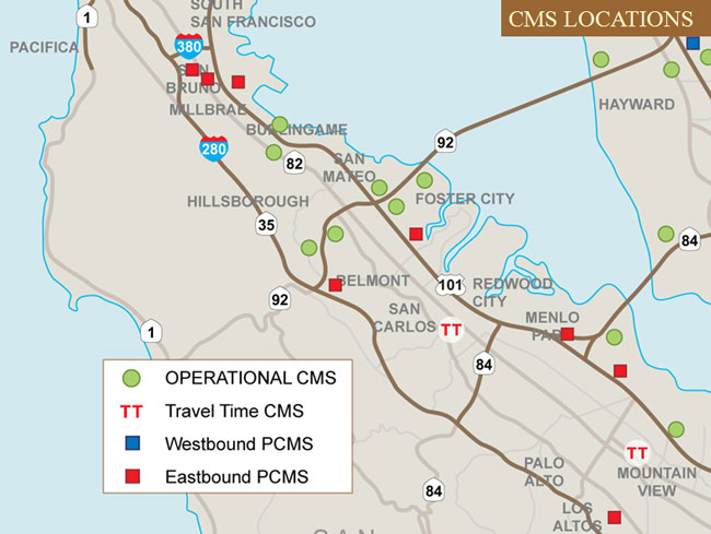
Slide 89. CMS Locations
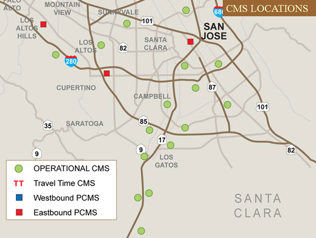
Slide 90. CMS Locations
Slide 91. CMS Locations
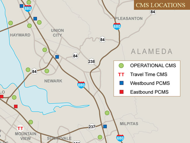
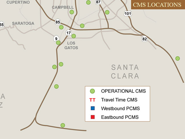
Slide 92. CMS Locations
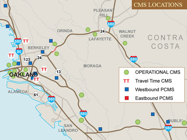
Slide 93. CMS Locations
Slide 94. Highway Advisory Radio (HAR)
- 2 to 5 Mile Range
- 1-minute message
- Deployment in San-Francisco-Oakland Bay Area (District 4) and Neighboring Districts (1, 3, 10)
Slide 95
Slide 96. HAR Locations
Slide 97. HAR Locations
Slide 98. Transportation Management
Slide 99. Two Command Centers
- San Francisco SFgo Transportation Management Center
- SFOBB Command Center in Oakland
Slide 100. Command Center Staffing
- Caltrans
- Executive Management
- Transportation Management
- Highway Operations
- Construction
- Public Information
- Police Departments
- Traffic Control Entities (CHP, SF Department of Parking & Traffic, City of Oakland, etc.)
- Emergency Services
- MTC / Bay Area Toll Authority (BATA)
Slide 101
Slide 102. Command Center Activities
- Real-time Traffic Detours Monitoring
- Near Real-time Traffic Impact Analysis
- Incident Monitoring
- Real-time Motorist Information
- Coordination & Information Exchange with Transportation Management Center (TMC)
- Daily Communication with Other Bridges on Detour Routes
Slide 103. Traffic Detours Monitoring, Traffic Volumes (via Vehicle Detector Stations)
- Eastbound
- NB US-101 just north of Golden Gate Bridge
- NB US-101 just south of Sir Francis Drake Blvd off ramp
- EB SR-92 just west of San Mateo-Hayward Bridge
- EB SR-84 just west of Dumbarton Bridge
- Westbound
- SB US-101 just north of Golden Gate Bridge
- SB US-101 just south of Sir Francis Drake Blvd on ramp
- WB SR-92 near San Mateo-Hayward Bridge toll plaza
- WB SR-84 near Dumbarton Bridge toll plaza
Slide 104. Traffic Detours Monitoring, Travel Time (via 511)
- Eastbound
- North detour: via NB US-101 @ Golden Gate Bridge toll plaza to EB I-580 to I-580/I-80 I/C
- South detour: via SB US-101 @ I-280 I/C to EB SR-92 to NB I-880 to I-880/I-238 I/C
- Westbound
- North detour: via NB I-580 @ I-80 I/C to WB I-580 to SB US-101 @ Golden Gate Bridge toll plaza
- South detour: via SB I-880 @ I-238 I/C to WB SR-92 to NB US-101 @ I-280 I/C
Slide 105. Traffic Impact Analysis
- Based on detour routes monitoring results
- Divert traffic from San Mateo-Hayward Bridge to Dumbarton Bridge
- Advise EB SR-92 traffic to use alternate routes on surface streets
- Advise NB US-101 traffic to use Bellam Blvd off ramp to EB I-580
Slide 106. Incident Monitoring
- During the full bridge closure, TMC will:
- Review District-wide CHP / CAD incident logs
- Identify logs for incidents along the mainline detour routes that are impacting traffic (stalls, accidents, debris, etc.)
- Identify those that require action by Maintenance / field personnel
- Coordinate and exchange information with the SFOBB Command Center and media
- Activate / modify CMS / HAR messages
- Use 511 to update motorists of traffic conditions
- Issue Sigalerts as needed
Slide 107. Incident Management Tools
- Closed Circuit Television Cameras (CCTVs)
- Construction Zone Enhanced Enforcement Program (COZEEP)
- Caltrans Bridge Tow Truck Service
- Freeway Service Patrol (FSP)
- Local Traffic Control
Slide 108. Construction Strategies
Slide 109. Construction Strategies
- Experienced Contractors
- Construction Staging
- Continuous Construction Schedule Monitoring
- Command Center for Information Update
Slide 110. Contingency Plan
- Additional Construction Equipment on Standby (Construction Contingency Plan)
- Emergency Public Information and Media Outreach Plan
- Emergency Transportation Response Plan
Slide 111. Demand Management
Slide 112. Additional BART Service
- Enhanced Daytime Service
- During BART regular hours of operation
- All Night Service
- During the hours when BART does not normally operate
- Saturday 1 AM to 6 AM
- Sunday 1 AM to 8 AM
- Monday Holiday 1 AM to 6 AM
- Hourly service to 14 stations
- During the hours when BART does not normally operate
Slide 113. Additional Ferry Service
- Alameda-Oakland Ferry
- Between Alameda, Oakland, and San Francisco
- Vallejo BayLink Ferry
- Between Vallejo and San Francisco
- Supplemental Vallejo Baylink 200 bus service
Slide 114. Additional Ferry Service
- Golden Gate Ferry
- Between Larkspur and San Francisco
- With added direct transit service (Route 42) between East Bay and the Golden Gate Larkspur Terminal
- Between Sausalito and San Francisco
- Between Larkspur and Sausalito
- New direct ferry service
- Between Larkspur and San Francisco
Slide 115. Alternate Route Strategies
Slide 116. Alternate Route Strategies
- Additional Temporary Traffic Capacity on Alternate Routes
- Additional Toll Collectors at Other Bridges
Slide 117. Temporary Additional Traffic Capacity
- SB I-880 / WB SR-92 Ramp
- Add a lane on the ramp
- Use inside shoulder for WB SR-92 through traffic
- Close Hesperian Blvd off ramp
Slide 118. Post-Evaluation Study
- Summary of Changes to Scheduled Events
- Traffic Volumes
- Travel Time Delays
- Transit Ridership
- Operational Impacts Caused by Accidents
- Lessons Learned
Slide 119. Special Thanks
- Toll Bridge Program Oversight Committee
- Will Kempton, Director, Caltrans
- Andre Boutros, Acting Executive Director, California Transportation Commission
- Steve Heminger, Executive Director, Metropolitan Transportation Commission/Bay Area Toll Authority
- Project Management Team
- Tony Anziano, Toll Bridge Program Manager, Caltrans
- Brian Maroney, Toll Bridge Program Deputy Manager, Caltrans
- Stephen Maller, Deputy Director, California Transportation Commission
- Andrew Fremier, Deputy Executive Director, Metropolitan Transportation Commission/Bay Area Toll Authority
- Caltrans Project Manager, Ken Terpstra