Seattle (Lake Washington) Urban Partnership Agreement
Seattle Urban Partnership Agreement
Additional Information
National Evaluation Report [PDF 10.2MB]
Full-Facility Congestion Pricing
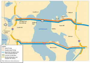
SR-520, a major access freeway into downtown Seattle from the East and from Seattle to eastside employment locations, experiences serious congestion between I-5 and I-405, carrying twice as much traffic as it was designed to carry, and its floating bridge over Lake Washington is vulnerable to earthquakes and windstorms and is structurally in need of replacement. To address current congestion, and also the 40 percent of throughput capacity that the region claims is sometimes lost on SR-520 due to it, King County, Washington, the Puget Sound Regional Council, and the Washington State Department of Transportation introduced new tolls on SR-520, setting toll rates on the facility based upon demand so as to avoid the build-up of congestion and the loss of roadway capacity when it is most needed. Toll rates are communicated in real-time, and revenues from tolling will be used to help finance the bridge replacement.
The project deployed "open road" electronic toll collection equipment, allowing tolls to be collected at freeway speeds. Tolls are collected using in-vehicle transponders, with supplemental automatic cameras to read license plates for vehicles not equipped with transponders.
Other Supporting Urban Partnership Elements
In addition to pricing tolls based upon demand and deploying electronic tolling technologies, the region deployed active traffic management techniques. Such techniques allow for the detection of incidents, facilitate the removal of disabled vehicles, and provide travelers with real-time information about traffic conditions, such as through 511 and electronically changeable roadway signage. Variable speed limit signs were installed to facilitate smoother traffic flow during peak travel periods.
Substantial transit improvements were deployed to further reduce congestion in the SR-520 corridor and to provide travelers real alternatives to driving and paying the congestion tolls. Twenty 60-foot and twenty-five 40-foot hybrid motor coaches were purchased, and bus stops were improved through the provision of real-time information signs about bus arrivals (at seven stops) and improved passenger shelters and lighting (at two stops). Park-and-ride facilities were expanded by replacing a 613-space surface parking lot with an 853-space parking garage and also by building a new 386-space parking garage.
Ferry transit is especially important in the Seattle region, and the Urban Partnership Agreement provided expanded opportunities to travel by ferry, and thus to reduce use of surface transportation modes. Ferry investments supported the Mukilteo multimodal terminal; to provide high-speed, ultra-low-wake passenger ferries and other vessels for the Puget Sound; to enhance passenger-only ferry service to and from Vashon Island; to bolster the Kingston Express ferry service; to support a Pierce County ferry system; and, to repair the Guemes Island ferry dock.
Using its own funding, the region expanded telecommuting opportunities and transportation demand management, beyond its highly acclaimed existing efforts. Partners increased outreach to employers and Transportation Management Associations about alternative transportation options and incentives to use them, and provided improved traveler information and trip planning services to employees. Marketing of the region's Guaranteed Ride Home program was expanded. This program serves transit commuters and carpoolers who need to return home in an emergency.
You may need the Adobe Acrobat Reader to view the PDFs on this page.

