Model Transportation Systems Management and Operations Deployments in Corridors and Subareas Primer1. IntroductionThe purpose of this document is to showcase to State, metropolitan, and local planners, transportation engineers, and decision-makers an effective and sustainable strategy, program, and package of project deployments for transportation systems management and operations (TSMO) for corridors or subareas. The document presents six illustrative packages of TSMO strategy deployments with varied geographic, social, and institutional contexts to serve as examples for advancing State, regional, and local plans and programs for TSMO. The concept behind this document is to help planners, transportation engineers, and decision makers apply a comprehensive approach to the deployment of TSMO in corridors and subareas. This primer will enable planners and transportation engineers to think beyond deploying TSMO on a project-by-project basis to defining and advancing a "package" of project deployments, institutional advancements, and programs that can meet longer term strategic and operational objectives in a corridor or subarea. Transportation agencies, particularly at the State and regional levels, have increasingly sought to optimize the existing transportation system using TSMO strategies. These efforts have resulted in statewide and regional policies and programs. A largely untapped opportunity to further optimize the transportation system lies in applying an integrated approach to planning and deploying TSMO in corridors and subareas. The target audience of this primer includes:
This introduction describes TSMO and its benefits, provides an overview of TSMO planning within corridors and subareas, and provides a guide for using this primer. A corridor is a linear system of multi-modal facilities in which an existing roadway or transit facility will typically serve as the spine of the corridor. The travel shed helps determine the length and breadth of a corridor area, which usually connects major activity centers or logical destinations. Corridors range in length from a few miles in an urban location to hundreds of miles for State or multistate corridors. In addition to different spatial scale, corridors may have different modal focuses, e.g., freight rail, high capacity passenger rail, limited access highway, and bus rapid transit. A subarea encompasses a network of transportation facilities for a given geographic area. Subareas are generally defined as a portion of a region, such as a local municipality (city or county), a downtown or central business district, or a neighborhood. Planning for subareas typically addresses a broader planning context, which may include a wide array of topics, including transportation, land use, and urban design. WHAT IS TRANSPORTATION SYSTEMS MANAGEMENT AND OPERATIONS AND WHY IS IT BENEFICIAL?TSMO encompasses a broad set of strategies that optimize the safe, efficient, and reliable use of existing and planned transportation infrastructure for all modes. TSMO is undertaken from a systems perspective, which means that strategies are coordinated with related strategies and collaboration occurs among many stakeholders and modes. TSMO strategies range from managing operational systems, like traffic signals, to managing travel demand, like traveler information. TSMO proactively addresses a variety of transportation system user needs by:
TSMO strategies are supported by both institutional and technology-based activities. On the institutional side, TSMO is enabled by memoranda of agreement between agencies, operations policies and procedures, and shared resources (e.g., interoperable communications systems, centralized traffic signal operations, and closed circuit television video sharing). Technology enables real- time operations of the transportation system by controlling traffic flow, delivering pre-trip and en-route travel information, and delivering data for optimizing system efficiency. TSMO strategies help transportation agencies address transportation issues in the near-term with lower cost solutions. TSMO strategies deliver a variety of benefits including:1 Safer travel. For example, freeway ramp metering has been demonstrated to reduce crashes by 15 to 50 percent. More free time. Among other time-saving TSMO strategies, traffic signal retiming decreases delay on roads by 13 to 94 percent, and transit signal priority (TSP) reduces transit delay by 30 to 40 percent. Improved reliability. Strategies that reduce unexpected delays (e.g., incident management, road weather management, and work zone management) enable the public and freight shippers to reduce unexpected delays. TSP improves transit on-time performance. Less wasted fuel. Traffic incident management (TIM) programs help to clear incidents safely and quickly. They reduce time lost and fuel wasted in traffic backups. For example, Georgia's TIM program (NaviGAtor) reduced annual fuel consumption by 6.83 million gallons per year. National studies have shown that integrating traveler information with traffic and incident management systems could improve fuel economy by about 1.5 percent. Cleaner air. TSMO strategies result in cleaner air by encouraging alternative modes of transportation (e.g., transit, ridesharing, biking, walking, and telecommuting) and reducing excess idling due to congested bottlenecks. Baltimore, Maryland's use of electronic toll collection reduced harmful emissions at toll plazas by 16 to 63 percent. OVERVIEW OF TRANSPORTATION SYSTEMS MANAGEMENT AND OPERATIONS PLANNING WITHIN CORRIDORS AND SUBAREASThis primer provides a set of six examples for how the TSMO planning process can be used to identify and deploy management and operations strategies that help address community needs and goals. It illustrates an integrated set of TSMO strategies across multiple program areas working together to achieve operations objectives within a corridor or subarea context. The objectives for this primer are to:
The TSMO planning process illustrated in this primer is founded on three themes that are consistent with noteworthy practices for successful deployment:
This primer depicts the planning process and resulting strategy deployments within a variety of corridor and subarea contexts. The intent is to demonstrate how TSMO strategies can be applied across different geographic settings and address a wide variety of community needs and issues. Further, it shows how integrated sets of strategies can be deployed and operated in different contexts to achieve operational goals. For in-depth guidance, see the Planning for Transportation System Management and Operations within Corridors Desk Reference2 and the Planning for Transportation System Management and Operations within Subareas Desk Reference.3 HOW TO USE THIS PRIMER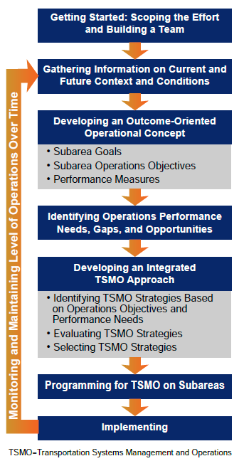
Figure 1. Diagram. Approach to planning for transportation systems management and operations within corridors or subareas.
Figure 1 shows the overarching approach to planning for TSMO within corridors or subareas. There is no one-size-fits-all approach to TSMO planning and implementation; however, proven practices and lessons learned can be applied. The primer uses six different examples to demonstrate the planning for TSMO approach. This section is a guide to help orient the primer user to the layout and use of the example deployments as they relate to the planning approach. Gathering Information on Current and Future Context and ConditionsEach model corridor or subarea includes example background information on geographic extent (e.g., rural, suburban, urban); land use context (e.g., commercial, industrial); corridor transportation facilities (e.g., arterials, collectors); transportation modes (e.g., automobiles, transit, bicycles); existing institutional capabilities (i.e., degree of organizational readiness for deploying TSMO); and motivators driving the need to improve the corridor or subarea. While the examples focus on these aspects, practitioners should also take into consideration previous studies, reports, and plans; information on current system performance; anticipated future conditions and contexts; and stakeholder input. Developing an Outcome-Oriented Operational ConceptGoals establish the desired end state of the plan. Operations objectives state the desired operational performance in each corridor or subarea. The goals and operations objectives are the link between the identified motivators and the set of TSMO strategies developed through a planning process. They are linked to quantitative or qualitative performance measures that document change over time. A set of goals are defined that respond to the unique combination of motivators identified for each model corridor and subarea. Supporting each goal are one or more operations objectives. Individual operations objectives are written statements for desired performance. They are SMART statements—specific, measurable, agreed upon, realistic, and time-bound—and have performance measures linked to them. The SMART operations objectives shown in this primer are for illustrative purposes only. Practitioners should take into consideration current system performance when developing specific corridor or subarea operations objectives and agree upon realistic targets for improvement. For more information on the objectives-driven, performance-based planning for operations approach, see the Federal Highway Administration's (FHWA) Advancing Metropolitan Planning for Operations: The Building Blocks of a Model Transportation Plan Incorporating Operations – A Desk Reference.4 Identifying Operations Performance Needs, Gaps, and OpportunitiesOften a key step in understanding existing performance needs, gaps, and opportunities is to conduct a scenario planning exercise. Operational scenarios should be defined by corridor or subarea stakeholders and may include a normal or daily scenario, a traffic incident scenario, a planned event scenario, a weather-related, emergency or evacuation scenario, or a major work zone scenario. Although not implicitly described in this primer, guidance on scenario planning is provided in FHWA's Advancing Transportation Systems Management and Operations Through Scenario Planning Primer.5 Developing an Integrated TSMO ApproachA set of TSMO strategies that address the motivators, goals, and operational objectives are identified for each corridor and subarea. The strategies are generally organized into one or more of the eight TSMO program areas described later in this section. The selection of TSMO strategies based on goals and operations objectives forms the basis of an integrated management and operations approach. While this primer demonstrates an idealized complete TSMO system, it is important to acknowledge that a corridor or subarea may have some of the desired TSMO strategies in place today and the planning effort will augment these strategies with new devices, communications, or program activities. The primer intends to instill the practice of looking at the transportation system holistically to create a sustainable, integrated program of TSMO strategies within a corridor or subarea. Evaluating the strategies to determine how well they meet defined operations objectives and whether they should be implemented all at once or phased in is an important part of determining the best set of TSMO strategies for the corridor or subarea. Common methods and analysis tools used for evaluating TSMO strategies include travel demand models, sketch-planning tools, analytical/deterministic tools, simulation models, and hybrid approaches. FHWA's Organizing and Planning for Operations Analysis and Simulation Tools website provides resources.6 Also, FHWA's Active Traffic Management Feasibility and Screening Guide provides examples for screening and evaluating active traffic management strategies.7 A similar process may be used for other TSMO strategies. There are more TSMO strategies than can be covered in this primer. The appendix includes a list of TSMO strategies and the panel at right lists the FHWA operations program areas, which correspond to many of the TSMO strategy areas listed below. FHWA Operations Program AreasFHWA's Office of Operations web page provides a wealth of guidance online, including dedicated web pages for each program area: https://ops.fhwa.dot.gov/program_areas/programareas.htm. Reducing Non-Recurring Congestion
Reducing Recurring Congestion
Improving Day-to-Day Operations
Creating a Foundation for 21st Century Operations
Improving Global Connectivity by Enhancing Freight Management and Operations
Improving Mobility and Security through Better Emergency Management
Traffic Management and Operations. The application of management practices and operations strategies that promote the safe and efficient use of freeway and arterial roadway capacity to reduce congestion and increase safety. Examples of strategies that fall under this category include network surveillance, coordinated signal timing, adaptive signal timing, ramp metering, variable speed limits, and queue warning systems. Road Weather Management. The use of strategies to minimize or eliminate the impacts of weather events such as rain, snow, high winds, or flooding on safe and reliable travel. Examples of strategies that fall under this category include the use of road weather information systems (RWIS) for weather responsive traffic management that are supported by variable speed limits, vehicle restrictions, and warning systems. Work Zone Management. The practice of managing traffic impacts during construction to maximize traveler and worker safety, minimize traffic delay, maintain access for adjacent land uses, and support timely completion of construction. Examples of strategies that fall under this category include automated enforcement, queue warning, traveler information, and variable speed limits. Planned Special Events Management. The practice of advanced planning and coordination to manage travel before, during, and after an event. Examples of strategies that fall under this category include real-time parking information, travel time information, and special signal timing plans. Travel Demand Management. The policies and strategies aimed at enhancing travel opportunities and choices that make more efficient use of the transportation system. Examples of strategies that fall under this category include ridesharing systems, individualized marketing, and multimodal trip planning mobile device applications. Public Transportation Management. The use of strategies to improve transit service operations and increase safety of riders and the traveling public. Examples of strategies that fall under this category include transit signal priority, electronic fare collection systems, transit surveillance, and blind spot detection systems for pedestrians and bicyclists. Traveler Information. The use of strategies to deliver pre-trip and en-route information about travel options and conditions. Examples of strategies that fall under this category include dynamic message signs, wayfinding, and real-time transit arrival information. Traffic Incident and Emergency Management. The practice of coordinating resources across partner agencies and the private sector to quickly detect, respond to, and clear traffic incidents; and to plan and coordinate response to man-made or natural events causing or threatening injury or loss of life, property damage, human suffering, or financial loss. Examples of strategies that fall under this category include dedicated incident response service patrols, computer-aided dispatch (CAD) integration, and TIM teams. Each example corridor and subarea includes a decision-tree that graphically depicts how each strategy relates to the topic areas and the identified goals. The intent is demonstrate to the primer user how a set of TSMO strategies in a corridor or subarea helps achieve the desired goals and operational outcomes. Programming and Implementing TSMO on Corridors and SubareasMoving from the planning stage to programming and implementing TSMO typically requires improvements to existing institutional capabilities, which describe the degree of organizational readiness for deploying TSMO. Each model corridor or subarea provides examples for advancing business processes, systems and technology, performance measurement, culture, organization/ workforce, and collaboration. Additional FHWA guidance for organizing for operations is described in Creating an Effective Program to Advance Transportation System Management and Operations Primer8 and the related document entitled Developing and Sustaining a Transportation Systems Management & Operations Mission for Your Organization: A Primer For Program Planning.9 The final section of the primer, presents a collection of key factors for the implementation of TSMO strategies that can be applied across all six examples. Factors are grouped into the following three categories:
Guide to Model Corridors and SubareasTable 1 provides a cross-reference of the model corridors and subareas to common motivators used in this primer. For practitioners looking for a place to dive in to this primer, this cross-reference allows you to find which motivator(s) exist in a corridor or subarea of interest in your community and identify which example may provide the most applicable ideas.
1 U.S. Department of Transportation, Intelligent Transportation Systems Joint Program Office, Investment Opportunities for Managing Transportation Performance through Technology, January 2009. Available at: https://www.its.dot.gov/press/2009/transportation_tech.htm. [ Return to note 1. ] 2 Federal Highway Administration, Planning for Transportation Systems Management and Operations within Corridors – A Desk Reference, FHWA-HOP-16-037 (Washington, DC: September 2016). Available at: https://ops.fhwa.dot.gov/publications/fhwahop16037/index.htm. [ Return to note 2. ] 3 Federal Highway Administration, Planning for Transportation Systems Management and Operations within Subareas – A Desk Reference, FHWA-HOP-16-074 (Washington, DC: October 2016). Available at: https://ops.fhwa.dot.gov/publications/fhwahop16074/index.htm. [ Return to note 3. ] 4 Federal Highway Administration, Advancing Metropolitan Planning for Operations: The Building Blocks of a Model Transportation Plan Incorporating Operations – A Desk Reference, FHWA-HOP-10-027 (Washington DC: April 2010). [ Return to note 4. ] 5 Federal Highway Administration, Advancing Transportation Systems Management and Operations Through Scenario Planning, FHWA-HOP-16-016 (Washington DC: October 2015). Available at: https://ops.fhwa.dot.gov/publications/fhwahop16016/index.htm. [ Return to note 5. ] Federal Highway Administration, Analysis and Simulation Tools, https://ops.fhwa.dot.gov/plan4ops/focus_areas/analysis_p_measure/simulation_tools.htm. [ Return to note 6. ] 7 Federal Highway Administration, Active Traffic Management Feasibility and Screening Guide, FHWA-HOP-14-019 (Washington DC: May 2015). Available at: https://ops.fhwa.dot.gov/publications/fhwahop14019/index.htm. [ Return to note 7. ] 8 Federal Highway Administration, Creating an Effective Program to Advance Transportation System Management and Operations Primer, FHWA-HOP-12-003 (Washington DC: January 2012). Available at: https://ops.fhwa.dot.gov/publications/fhwahop12003/index.htm. [ Return to note 8. ] 9 Federal Highway Administration. Developing and Sustaining a Transportation Systems Management & Operations Mission for Your Organization: A Primer For Program Planning, FHWA-HOP-17-017 (Washington, DC: September 2017). Available at: https://ops.fhwa.dot.gov/publications/fhwahop17017/index.htm. [ Return to note 9. ] | |||||||||||||||||||||||||||||||||||||||||||||||||||||||||||||||||||||||||||||||||||||||||||||||||||
|
United States Department of Transportation - Federal Highway Administration |
||