
Freeway Management and Operations Handbook
Chapter 13 – Information
Dissemination
Page 1 of 3
13.1 Introduction
The effective dissemination of traveler information services supports many types of information requests and categories of travelers, and combines multi-modal information in an effective and timely manner. Information may be provided in a number of ways, including static information and real-time information. Static information comes from such sources as transit schedules, planned work zones, and known road closures. Real-time information comes from a variety of sources including roadway-based sensors, surveillance equipment, and drivers. The information assists travelers in selecting their mode of travel, route, and departure times – both pre-trip and enroute. Figure 13-1 illustrates the possibilities of range of data sources, processing and uses of traveler information. The figure depicts the various sources of data (left-hand side, and including freeway conditions) which are collected and centrally processed (central part of figure) to yield integrated information about the current and future travel conditions; and which are broadcast or disseminated to travelers, allowing them to make informed choices about when, where and how to travel (1).
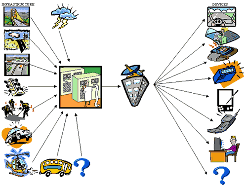
Figure 13-1: Sources and Uses of Traveler Information (Reference 1) D
As shown in the Figure – and like much that is discussed in this Handbook – the traveler information process extends well beyond the freeway, both in terms of where the information is obtained and how it is distributed. Information on freeway conditions and the dissemination of that information to freeway users should therefore be viewed as part of a broader, region-wide, advanced traveler information system (ATIS).
13.1.1 Purpose of Chapter
This Chapter is a tool for freeway practitioners of all levels involved with the dissemination of traveler information. It provides overview of the wide breadth of information dissemination treatments from planning to operations, including:
- The elements of an information dissemination system,
- Its role in freeway management (and the operation of the surface transportation network),
- Issues involved in planning and commissioning for information dissemination,
- Potential technologies for disseminating the information, and
- Operational considerations
Some topics within this chapter are covered in greater detail than others – the greatest emphasis being placed on those technologies and strategies that are directly related to the operation and management of the freeway itself. For example, significantly more emphasis is provided for Changeable Message Signs (CMS) as compared to dissemination of traveler information via Information Service Providers (ISP's). CMS are located on the freeway right-of-way and communicate directly with the driver, even though the latter method may have a greater impact in the context of the overall surface transportation network. Regardless, many of the issues and principles noted herein are applicable to all forms of traveler information.
Another consideration is the availability of more detailed references. In these cases, the references are noted and summarized. The Federal Highway Administration (FHWA) also maintains a website with up-to-date information on the dissemination of traveler information in the country. Its address is http://www.ops.fhwa.dot.gov/Travel/traveler_info.htm. Another FHWA website dedicated to the 511 traveler information program can be found at http://www.its.dot.gov/511/511.htm.
13.1.2 Relationship to Other Freeway Management Activities
The Chapter is but one of many in the Freeway Management and Operations Handbook, and has been developed to "stand alone" within its topic area to a great extent. Not lost on this, though, is the relationship of other elements of the freeway and surface transportation network (i.e., chapters within this Handbook) as well as numerous other references to the topic of information dissemination. These other chapters and references, in cooperation with this Chapter, provide the practitioner with an essentially complete reference of information, guidelines and practices to successfully plan, commission, operate and maintain a traveler information system.
There are many freeway management activities that are related to or dependent upon traveler information dissemination; and to understand the role of information dissemination within the freeway management spectrum, it is important to understand the relationships with these activities. In other words, traveler information dissemination cannot be addressed in a singular fashion. As shown in previous Figure 13-1, before the information can be disseminated it must first be collected from a variety of sources, the collected information must be combined (i.e., data fusion), and the affects of the disseminated information on traveler behavior must be continuously monitored and assessed. The following table itemizes those related activities and their relationship.
| Activity | Relationship |
|---|---|
| Ramp Management and Control (Chapter 7) Lane Management and Control (Chapter 8) |
For both ramp and lane management control, including construction and maintenance activities, it is important to convey the ramp or lane control conditions to the motorists. Devices typically attributed to traveler information, namely the changeable message sign (e.g., overhead lane control sign for lane management, portable CMS for construction), are used. |
| Traffic Incident Management (Chapter 10) Planned Special Event Management and Control (Chapter 11) Emergency & Evacuation Management (Chapter 12) |
Critical to the success of these management strategies in conveying real-time conditions to the pre-trip and en-route travelers. In the case of Planned Special Event Management, conveying future conditions, both known and predicted, such as a lane or road closures, is vital. |
| Traffic Management Centers (Chapter 14) | Most Traffic Management Centers house the central systems that process information, and control and manage the dissemination. |
| Surveillance and Detection (Chapter 15) | The surveillance subsystem provides much of the information that is disseminated to travelers. |
| Regional Integration (Chapter 16) | Information is shared across jurisdictional boundaries and information conveyed to the traveler can be "regional" in nature, (i.e., the effected area may not be in the local control area of the system, but may still effect local travelers.) |
13.2 Current Practices, Methods, Strategies, and Technologies
13.2.1 Overview
The key to successful driving task performance is efficient information gathering and processing (2). Likewise, properly communicating with motorists is critical to successful freeway traffic management and operations. Motorists rely on a wide variety of information to properly accomplish the control, guidance, and navigational aspects of the driving task. The roadway alignment and general terrain itself provides a great deal of this information through visual "cues;" sources such as pavement markings and regulatory, warning, and guide signs also contribute greatly to the overall information system. However, in an effective freeway management system, dynamic methods of conveying information to motorists or travelers are often needed to better operate and control the system.
Information dissemination is also managed in order to improve travel conditions in the corridor by influencing traveler behavior (by recommending diversion routes around an incident, for example). This information can be disseminated from a variety of sources (State departments of transportation, transit agencies, private-sector information service providers, etc.) using a variety of methods (changeable message signs, commercial radio traffic reports, traffic information kiosks, internet, etc.).
Traveler information can be categorized as either pre-trip or en-route.
- Pre-Trip Traveler Information. Pre-trip traveler information can provide the traveler with current roadway and/or transit information prior to deciding upon the time, mode, and route of travel. Whether provided to travelers at home, the workplace, park-n-ride facilities, transit stations, or multi-modal locations, this capability can help relieve congestion by giving the traveler the information to reroute, delay start of the trip, shift modes, or avoid travel altogether. Often, this information can support itinerary planning, which can provide information on a whole trip from one point to another, even if it involves multiple modes. Reliable pre-trip traveler information may also tend to spread the travel over space and time, making it more balanced. Convenience is essential to successfully implementing pre-trip traveler information systems. Touch-tone telephones, personal computers (Internet), pagers, personal data assistant (PDAs), kiosks, and automated data retrieval systems which augment existing human-operator interfaces have the potential to substantially improve the accessibility of desired traveler information, thus impacting travel behavior.
- En-Route Traveler Information. En-route traveler information can provide the traveler with current roadway and transit information while traveling en-route. Information is typically provided via devices deployed along the side of the roadway, or from devices mounted on the dashboard of the vehicle. Along the roadway, Changeable message signs and highway advisory radio messages typically provide information regarding traffic congestion, incident and construction locations, weather advisories, special events which may impact travel on a particular section of roadway, and alternative routes. In-vehicle and personal mobile devices can provide a variety of en-route traveler information to both the traveler as well as transportation providers. Mayday calling systems can alert emergency response and transportation system providers of a stranded or disabled vehicle's location. Sophisticated route guidance systems can assist motorists in route planning as well as providing timely directions via a computer synthesized voice.
Traveler information, pre-trip and en-route, can be categorized as either static or dynamic in nature. Static information can be defined as known or planned events, while real-time information can be defined as the most current available information at a given point in time. Real-time information differs from static information in that it continually changes based upon a wide variety of events.
- Static Information. Static traveler information required
by travelers can include:
- Construction and maintenance activities that reduce the number of travel lanes along a section of roadway.
- Special events that generate significant increases in traffic that can impact travel along specific roadways, and sections of roadways.
- Hours of operation of HOV lanes and carpool definition.
- Vehicle restrictions (height, weight, etc.)
- Real-time Information. Real-time information can
be disseminated both pre-trip and en-route. As an example, incident
information is just as critical to the traveler who routinely checks
the real-time travel conditions along his or her normal commuting route
as it is to motorists currently traveling along the route where the
incident has taken place. Real-time traveler information required by
travelers can include:
- Roadway travel conditions associated with travel delay, such as congestion, locations of queues, and incident locations
- Potential alternative routes which can facilitate travel, particularly in the event of a temporary roadway closure
- Weather advisories detailing snow, ice, and fog which can impact travel
- Park-n-ride lot status
Regardless of how it is provided, to be effective traveler information must be timely, complete, accurate, credible, available on demand, and perceived by the individual traveler as being relevant to their needs and providing a value when followed; otherwise, the information will be ignored. In general, for each inaccurate piece of information promulgated by the traveler interface elements, it will take numerous occurrences of accurate information to recapture the traveler's faith in the system.
13.2.2 Benefits
The dissemination of traveler information allows travelers to effectively plan their trip prior to departure; and when en-route, to avoid congestion and problems. Motorists and transit riders want to know their choices and know what to expect – such knowledge being a key attribute of "mobility". Having accurate and real time information about the performance of the surface transportation network significantly improves the perception of a trip because this information allows travelers to make decisions that give them the sense of having more control over their life. Such knowledge not only gives the traveler better options; it removes a significant stress point, the unknown.
An ATIS case study and survey in Washington D.C. (3) indicates that that the vast majority of current ATIS users are satisfied consumers who feel they save time by utilizing these services on a regular basis. The research suggests that ATIS users do realize significant benefits in terms of time management – better on-time reliability, reduced early and late schedule delay, as well as more predictable travel. They do this, however, without significantly reducing the amount of in-vehicle travel time accumulated over a month or year of regular trip making. Overall, ATIS use proved advantageous in efficiently managing the traveler's time. Specific quantitative examples selected from the Washington DC case study include:
- Peak-period commuters who do not use ATIS were three to six times more likely to arrive late compared to counterparts who use ATIS;
- Cases where ATIS clearly benefits the user (e.g., ATIS user on-time, non-user late) outweighed cases where ATIS clearly disadvantages the user by five to one;
- ATIS users in peak periods are more frequently on-time than conservative non-users, yet they experience only two-thirds as much early schedule delay as non-users. Late shock, the surprise of arriving late, is reduced by 81% through ATIS use.
13.2.3 Key Considerations During Freeway Management Program Development
The dissemination of traveler information for a freeway management system (or a regional Integrated Traffic Management System (ITMS) that incorporates the freeway network) is an integral part of operating and managing the freeway. As such, it must be a key consideration in every aspect of developing the freeway management program, including the activities noted below (referring to Figure 3-1 from Chapter 3).
13.2.3.1 Stakeholders
The information needs of travelers extend well beyond an agency's freeway infrastructure, and include other jurisdictions' freeways, the arterial network, transit facilities, airports, etc. The traveler information stakeholders must include all of these concerns. Moreover, as discussed in Section 13.3 herein, the private sector will also be an active partner in the traveler information process, and must be included as a stakeholder.
13.2.3.2 Concept of Operations
Because information dissemination must be coordinated among the various partners, a portion of the plan should be devoted to a discussion of the management structure and the agreements that will be utilized to achieve this coordination. Items to be included in this portion of the plan include:
- Names of contact person(s) for each partner.
- Protocols and methods to be utilized to coordinate.
- Definition of each partner's responsibilities regarding information exchange.
- Overview of each partner's contribution to the effort (cash, in-kind exchange of equipment or services, etc.).
- Letters or memoranda of agreement regarding the desire to coordinate among partners.
Additional details may need to be included in the letter of agreement if some of the partners will jointly operate some of the information dissemination technologies to be implemented. For example, a transportation agency may wish to allow law enforcement personnel to access and utilize their changeable message signs or highway advisory radio equipment for managing major incidents during late-night hours when the transportation agency does not have someone on duty.
13.2.3.3 Performance Measures
In order to assess the extent to which information dissemination efforts within a freeway management system are meeting goals and objectives, a set of performance criteria and measures-of-effectiveness pertaining to these efforts must be identified. With respect to information dissemination, performance criteria have several different, yet interrelated, dimensions that are of interest, including:
- Information credibility – Information must be credible to travelers if it is to be utilized and have an impact upon traffic operations. The following criteria define how credibility is established (4): the information must be accurate; the information must be timely; and the information must be relevant to its intended audience. This can be measured by a customer satisfaction metric.
- Market penetration – Market penetration refers to the percentage of the potential audience reached by the information dissemination efforts. Performance criteria regarding market penetration may be appropriate for evaluating certain system goals and technologies, particularly those emerging as part of Advanced Traveler Information Systems (ATIS). It is expected that some technologies, such as in-vehicle dynamic route guidance, will require only limited market penetration in order to achieve operational benefits. Other technologies, such as information kiosks in major traffic generators, may require agencies to strive for as great a market penetration as possible in order to distribute the information to a wider audience and possibly attract private sector advertising and sponsorship.
- Traveler response – Ultimately, the purpose of providing information to travelers is to effect some change in traveler behavior that will cause an improvement in safety or operations. Thus, performance measures are also needed to determine the extent to which information dissemination accomplishes this purpose. Changes in traveler mode, departure time, and route (if appropriate) are appropriate for evaluating the effectiveness of real-time travel-related information. However, it may be very difficult and expensive to obtain actual data for these measures. Traveler opinions about the effectiveness of the information being provided can be another important evaluation measure.
It is important to recognize that because of the complex travel patterns of travelers at any point in the roadway, it may not be possible to adequately measure the overall effects of many types of information or dissemination modes upon traffic volumes, speeds, or delays. The day-to-day variances in travel patterns themselves may mask the effects of any information disseminated during a specific event such as an incident, particularly if the information is intended for a very specific audience (such as vehicles within a freeway traffic stream destined for a specific downstream exit).
13.2.3.4 Evaluation
Care should be taken not to overestimate the benefits achieved by the implementation of information dissemination components in a freeway management program. Specifically, it is important to recognize that travel patterns in a freeway corridor are quite dynamic, and that some drivers will divert naturally when they encounter freeway congestion regardless of whether or not they receive information beforehand about that congestion.
It is also important to utilize the appropriate evaluation methodology. As noted in the aforementioned Washington D.C ATIS study (3), "if ATIS deployments are evaluated purely on time-savings, the benefits of ATIS will likely be grossly underestimated. ATIS users value improved travel reliability. The value of improved on-time reliability is not easily nor directly translated to purely monetary terms, but it is clear that many types of travelers can benefit from ATIS. Trucks delivering auto parts in a just-in-time manufacturing process may highly value any improvement in on-time reliability or reduction in early schedule delay. Commuters face an on-time requirement not only on the home-to-work leg of their daily trip making, but increasingly on the work-to-home return trip in order to meet daycare pickup requirements and other commitments. Improved reliability and predictability of travel are also likely good surrogates for reduced commuter stress. From this common sense perspective, it is clear that the benefit of improved travel reliability and predictability from ATIS will outweigh whatever small return is generated from the monetary equivalents of aggregate travel time reductions".
13.2.4 Relationship to National ITS Architecture
As indicated in Chapter 3, the National ITS Architecture provides a common structure or framework to promote compatibility and interoperability among systems, products, and services. The architecture defines the functions that must be performed to implement a given service, the physical entities or subsystems where these functions reside (e.g., the roadside or the vehicle), the interfaces / information flows among the physical subsystems, and the communication requirements for the information flows.
The National ITS Architecture can serve as the basic building block of the functional requirements definition process for detection and surveillance. The functions described in the National Architecture must then be detailed to match the needs and desires of the local agencies. The National ITS Architecture defines various ITS elements and strategies in terms of market packages. This concept recognizes that various ITS components must work together to achieve system goals. They are "tailored to fit separately or in combination-real world transportation problems." The National ITS Architecture defines a number of Market Packages associated with traveler information. Those most relevant to freeway operations and management include:
- Traffic Information Dissemination: This market package allows traffic information to be disseminated to drivers and vehicles using roadway equipment such as Changeable message signs or highway advisory radio.
- Broadcast Traveler Information: This market package collects traffic conditions, advisories, general public transportation, toll and parking information, incident information, air quality and weather information, and broadly disseminates this information through existing infrastructures and low cost user equipment (e.g., FM subcarrier, cellular data broadcast). The information may be provided directly to travelers or provided to merchants and other traveler service providers so that they can better inform their customers of travel conditions.
Other traveler information market packages include "Interactive Traveler Information", "Autonomous Route Guidance", "Dynamic Route Guidance", and ISP-Based Route Guidance, as defined in Reference 19. It is also noted that the draft Version 5 of the National ITS Architecture includes new market packages relevant to traveler information during emergencies – Wide Area Alert (which includes "Amber Alerts") and Disaster Traveler Information.
13.2.5 Technologies and Strategies
Information dissemination components of a freeway management system can range from a single device owned and operated by one agency, to an integrated collection of devices and mechanisms under the control of several agencies and several private sector entities. In this Handbook, a basic distinction is made between kinds of information dissemination technologies depending on which of three main locations it comes from:
- Those located on the roadway where the information transfer to the traveler occurs at a specific point or within a very small segment of roadway (e.g., Changeable message signs or highway advisory radios.)
- Those located within the vehicle where the information transfer is not constrained to a point or a small segment of roadway (e.g., commercial radio, cellular telephone, personal computing devices, or in-vehicle navigation devices).
- Those located off of or away from the roadway altogether, typically at the origin of the trip (e.g., television, internet, personal communication devices, telephones, or kiosks in major traffic generators).
Specific technologies are discussed below.
13.2.6 Changeable Message Signs
One of the most fundamental technologies available for disseminating traffic-related information from the roadside is that of changeable message signs (CMS). CMSs are sometimes (and interchangeably) referred to as dynamic message signs (DMS) or variable message signs (VMS). The term "DMS" is generally used within the context of the National ITS Architecture (19) and the associated standards. "CMS" is the term used in the MUTCD (Reference 21); and is also the terminology most widely used in this Handbook.
CMSs are programmable traffic control devices that can usually display any combination of characters to present messages to motorists. These signs are either permanently installed above or on the side of the roadway, or portable devices attached to a trailer or mounted directly on a truck and driven to a desired location. Portable CMSs are much smaller than permanent CMSs and are oftentimes used in highway work zones, when major crashes or natural disasters occur, or for special events (e.g., sport events) and emergency situations.
When installed, CMSs become a part of the total motorist information system. Thus the information presented on CMSs and the placement of the signs must be consistent and compatible with static signs used on the freeway. Highway signs – both static and changeable – must project a message so that the driver can:
- Detect the sign,
- Read and understand the sign,
- Make appropriate decisions based on the information gained from the sign.
And if necessary:
- Initiate a control response, and
- Complete the required maneuver. (5)
Section 2A.07 of the Manual on Uniform Traffic Control Devices (MUTCD – Reference 21) defines CMS as "traffic control devices", and requires that a CMS shall conform to the principles established in the MUTCD related to the use of signs within the right-of-way of all classes of public highways, and to the extent practical, the design and applications prescribed in Sections 6F.02 and 6F.52. Section 2E.21 of the MUTCD specifies that "Changeable message signs shall display pertinent traffic operational and guidance information only, not advertising." (Note: At the time of preparing this Handbook, a new part / chapter on changeable message signs is being developed for the MUTCD, and will be included in the next update.)
CMSs perform a critical role on freeways. Such signs can furnish motorists with real-time information that advises them of a problem and in some cases, a suggested course of action. CMSs are also used to improve motorist safety and reduce traffic congestion and delay. CMSs can be used to manage traffic by displaying the following types of messages: (5)
- Early warning messages give motorists advance notice of slow traffic and queuing ahead and are effective in reducing secondary crashes. When used in freeway work zones, early warning messages also give notice of new detours, changes in detour route, changes in lane patterns, special speed control measures, etc.
- Advisory messages provide motorists with useful information about a specific problem along their route. This information allows motorists to change their speed or path in advance of the problem area, or may encourage them to voluntarily take an alternative route to their destination.
- Alternative route messages influence motorists to travel to their chosen destination by using different routes than originally intended. The alternative route is one designated by the transportation agency. In cases when the freeway is physically closed as a result of construction, crash, or natural disaster, the motorists are notified that an alternative route must be used.
Table 13-2 lists the applications for which CMSs can be used. (6)
| Category | Applications |
|---|---|
| Traffic management and diversion |
|
| Warning of adverse conditions |
|
| Control at crossings |
|
| Control during construction and maintenance operations |
|
| Special-use lane and roadway control |
|
For the purpose of this Handbook, Changeable message signs have been classified into two categories, namely: those that have a fixed number of messages available for display; and those that essentially have an unlimited message capability (References 4, 5, 6).
13.2.6.1 Fixed Number of Messages
Signs with a fixed number of messages (Figure 13-2) include the following:
- Fold-out: A fold-out sign is a conventional highway sign with a hinged viewing face. This type of sign can either display two messages (one with the hinged face closed, one with it open) or show a message only when the hinged face is open (no message is displayed when the hinged face is closed). Typically, signing materials that conform directly to the Manual on Uniform Traffic Control Devices (MUTCD) are used to make each message. For freeway applications, they are most often used to indicate icy bridge or other hazardous roadway conditions, or to indicate whether truck weigh stations are open or closed.
- Rotating Drum: Rotating drum signs are made up of one to four multifaced drums, each containing two to six message elements (i.e., lines). Three-sided drums are used as well, and are sometimes referred to "prism" signs. Each face of each drum portrays one line of a fixed message, and pivots about its axis in order to display the appropriate face for a given message. Newer technology uses multiple louvers creating each "line" of the message. Colors and lettering characteristics that conform to the MUTCD can also be used on rotating drum signs.
- Neon or Blank-Out Signs: Neon signs use neon tubing
to form characters and messages that are to be displayed. Two basic
sign designs are possible:
- Separate each message on the sign face.
- Stack the neon tubing for each message one over another.
The stacked design has reported drawbacks, in that emitted light will be diffused as it passes through the overlayed neon tubing, reducing its legibility. Conversely, the separate message design will require a fairly large sign face in order to display even a moderate number of messages.
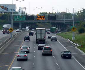

Figure 13-2: Example of Signs with Fixed Number of Messages
13.2.6.2 "Unlimited" Number of Messages
These CMSs display characters and symbols in a matrix format, which are generally designed in the following three patterns (7):
- Character Matrix: In this format, each character
of the desired message is composed of a 5 X 7 matrix of pixels. The
number of character per line varies, depending on the manufacturers
and the desired usage, although most transportation agencies deploy
three-line, 18-character CMSs. Practically all highway CMSs display
messages which use capital letters because the configuration of the
5 X 7 matrix does not lend itself to displaying lower-case letters.

- Line Matrix: In this format, the display lines are
separate from each other, with each line consisting of continuous matrix
of pixels, as shown below.

- Full Matrix: In this format, the entire display consists
of continuous matrix of pixels, as shown below.

It should be noted that although line matrix and full matrix CMSs provide flexibility in displaying different characters and symbols varying in sizes, it has been shown that in many cases, fewer characters can be displayed on a line of continuous matrix or full matrix CMS than can be displayed on a line with character matrix because of the width required for proportional characters.
13.2.6.3 Matrix Technologies
Matrix technologies include the following:
- Reflective Disk Matrix. These types of CMSs were very popular for freeway management purposes in the 1970s due to their low energy requirements relative to light-emitting CMS technologies. The viewing face of a reflective disk matrix CMS is comprised of an array of permanently magnetized, pivoted indicators that are flat matte black on one side and reflective yellow or a similar color on the other. The indicators may be square, rectangular, or circular in shape. An electrical current activated when a given pixel is to be turned flips the indicator from a black matte finish to the reflective side. A major disadvantage with disk signs is the need to illuminate the sign at night, sometimes causing glare or blurring problems. Another potential problem is tendency for some of the disks to stick over time due to excessive dirt or moisture. Only a few new CMS use this technology today, except in concert with light emitting devices (i.e., hybrid signs as discussed later) or for small specialty signs (e.g., patron fare displays at toll plazas).
- Shuttered Fiberoptic Signs. Fiberoptic CMSs funnel light energy from a light source through fiber bundles to the sign face. In a matrix configuration, the shuttered fiberoptic CMS positions the ends of the fiber bundles on the sign face in an array similar to that used for other matrix signs. The light sources for all of the fiber bundles remain on constantly, and shutters at the ends of the bundles open and close to create the characters needed to display each message. These signs have experienced very low failure rates. The one potential disadvantage is the relatively narrow cone of vision, making sign placement relative to the drivers' eyes an important consideration.
- Light-Emitting Diode (LED) Signs. Light-emitting diodes (LEDs) are semiconductors that glow when voltage is applied. Typically, several individual LEDs are "clustered" together in order to create each pixel. LEDs have the added benefit of being able to display signs in full color. The reliability of LED lamps is very high. Like fiber optic CMS, the cone of vision is relatively narrow.
- Hybrid CMS. Hybrid CMS combine reflective disks with a light-emitting technology (i.e. fiber optic, LED). Hybrid signs offer several advantages – great visibility when the sun is shining directly on the sign face, and no need for external lighting on the sign at night. Hybrid signs also have the disadvantages of both sets of technologies.
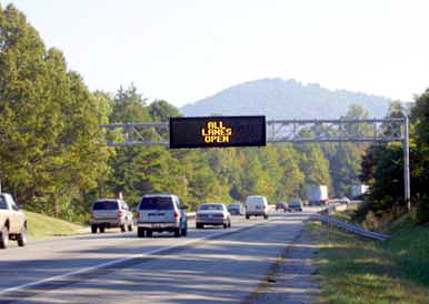
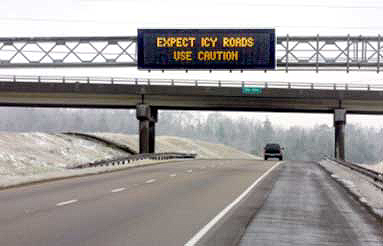
Figure 13-3: Examples of Light-Emitting Matrix CMS Technologies (Courtesy of Virginia DOT)
13.2.6.4 Sign Location and Design
The most critical locations for installing permanent CMSs are in advance of interchanges or highways where drivers have the opportunity to take some action in response to messages displayed on CMSs. A CMS should not compete with existing roadway signs. At times, relocation of some static signs may be required in order to install a CMS at a critical location. In general, a CMS should be permanently installed at the following locations: (4, 7)
- Upstream from major decision points (e.g., exit ramps, freeway-to-freeway interchanges, or intersection of major routes that will allow drivers to take an alternate route).
- Upstream of bottlenecks, high-accident areas, and/or major special event facilities (e.g., stadiums, convention centers).
- Where regional information concerning weather conditions such as snow, ice, fog, wind, or dust is essential.
The ease with which a sign can be detected in the environment (conspicuity) and the ease with which the message can be read (legibility) will enhance the effectiveness of motorists' visibility of the CMS and its message. In addition, the manner in which the message is displayed must be considered (e.g., if the message is too luminous, it can be easily detected but difficult to read because of glare.) Factors that affect the legibility of light-emitting CMSs include the character height; font style; character width (spacing and size of pixels); spacing of characters, words and lines; size of sign borders; and contrast ratio. (7)
The CMS designer and operator need to know about the actual site characteristics in the vicinity of the CMS. These characteristics dictate the amount of information that can be displayed. Among the items of interest are the following: (5)
- The operating speed of traffic on the roadway;
- The presence and design characteristics of any vertical curves affecting sight distance;
- The presence of horizontal curves and obstructions such as trees, bridge abutments, or construction vehicles that constrain sight distance to the CMS around the curve;
- The location of the CMS relative to the position of the sun (for daytime conditions);
- The presence, number, and information on static guide signs in the vicinity; and
- Whether or not rain or fog is present to degrade visibility to the sign.
Other design considerations include: sign size (which affects message length as well as support structure requirements), maintenance access (e.g., walk-in housings, front access), technology, viewing angle and distance, character size, and sign position relative to sun during various times of day and days of the year.
As discussed later, the maximum length of a message that should be displayed is primarily dictated by the amount of information drivers can read and comprehend during the period when they are within the legibility distance of the CMS. The maximum length of a CMS message is also controlled by the characteristics of the sign. These include the type of sign (LED, fiberoptic, etc.), the number of lines available, and the number of characters on each line. Each of these characteristics can have an effect on how far away the CMS can be read and, consequently, how much information can be presented to motorists. It should be the responsibility of the TMC manager/supervisor to assess the CMS characteristics and determine the maximum length of message to display.
Too often agencies will purchase CMSs before signing objectives and messages are determined. Often, this causes disappointment in the CMSs when these agencies cannot display the desired messages, or when the signs provide lower than expected target value and legibility for the environmental conditions present at the site. (4) Conversely, agencies may end up purchasing a more expensive CMS with capabilities that exceed their actual needs. (Additional information on developing CMS messages is provided in Section 13.3)
13.2.6.5 Portable CMS
The use of trailer-mounted CMS provides an agency with a great deal of flexibility. The signs, which are typically much smaller than permanent, over-the-road CMSs, are used most commonly for temporary applications, such maintenance and construction activities. They are usually diesel- or solar-powered and use wireless (cellular) communications to a central management point, making them a very attractive and flexible tool.
Portable changeable message signs are usually located at the side of the road, and do not sit as high as an overhead sign, which can impair drivers visibility. Most are 3-line, 8 or 9-character signs, and although most have the capability of displaying multiple phases, they tend to be used with simple short messages to allow drivers to read and comprehend the message. The MUTCD states that no more than two phases shall be used to display a message. These signs use all of the aforementioned technologies. Figure 13-4 shows a portable CMS in a work zone.
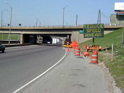
Figure 13-4: Portable CMS in Operation in a Work Zone
13.2.6.6 Standards
The U.S. DOT strongly encourages state and local agencies to use DMS standards (Note: As previously noted, when describing standards and other attributes of the National ITS Architecture, the term "DMS" is typically used.). DMS standards are mature, they have undergone significant testing, and they offer immediate benefits for agencies by 1) providing interoperability between DMS and other NTCIP-compatible field devices running on common communications channels, and 2) enabling simplified administration of DMS subsystems, leading to easier overall administration. (8)
As of the time of writing this Handbook, the DMS NTCIP working group is drafting Version 2 of NTCIP 1203, Object Definitions for Changeable Message Signs. Version 2 represents a major upgrade in the functionality of the DMS standard. NTCIP 1203 allows integration of DMS devices and products from multiple manufacturers into a single system using standard communications and data. Version 2 adds features such as graphics and device status reports. This version also restructures the standard to make it easier for end users to specify product attributes and/or capabilities. A major benefit of Version 2 for end users concerns customization. Version 2 adds features and functions, such as color, that could be obtained previously only by deviating from the standard through customization.
The "Specification Guide for Procurement of NTCIP-compliant Dynamic Message Signs" (Reference 9) is a tool by which practitioners may develop a meaningful NTCIP procurement specification to purchase interoperable and interchangeable DMS. As a rule, the document does not require specific features; rather it defines how the user may include such requirements within a specification. For example, the sample wording in reference indicates how one would specify how many messages the sign should store, but does not specify a quantity as that is a project-specific decision. It is emphasized that reference is "not intended to be an educational tool explaining the concept of operation for DMS"; rather it assumes the reader / specification writer has an understanding of DMS functions and technologies.