
Freeway Management and Operations Handbook
Chapter 13 – Information
Dissemination
Page 2 of 3
13.2.7 Highway Advisory Radio
Although not as widely used as CMS, Highway Advisory Radio (HAR) is another means of providing highway users with information in their vehicles. Traditionally, information is relayed to highway users through the AM radio receiver in their vehicles. Upstream of the HAR signal, users are instructed to tune their vehicle radios to a specific frequency via roadside or overhead signs. Usually, the information is relayed to the users by a prerecorded message, although live messages can also be broadcast.
Highway advisory radio (HAR) is an effective tool for providing timely traffic and travel condition information to the public. It has various advantages and disadvantages. It's most important advantage is that it can reach more travelers, or potential travelers, than Changeable Message Signs (CMS). While CMS's reach only those motorists at a particular point, and can only convey a short message, HAR has the advantage of being able to communicate with any persons in their broadcast range. Further, the amount of information that can be conveyed is much greater. Its primary disadvantages are that it is restricted to low power, and this leads quite often to poor signal quality (since it affected by many outside forces such as weather), and it requires the driver to take an action (i.e., turn on the radio or change the station or both). This can lead to poor listenership.
HAR is an element of the Federal Communication Commission's (FCC) Traveler Information Systems designation. They are permitted under strict FCC guidelines and regulations associated with technology and operations. They are licensed as a secondary user, which means simply that they cannot interfere with a primary user, i.e., a commercial broadcast station. As a secondary user, HAR broadcasts are restricted in signal strength, a level that limits their transmission range to no more three or four miles from the transmitter. A number of technologies are available for HAR transmission, using both AM and FM bands.
Typically, HAR has been implemented using 10-watt AM transmitters. This is because, beginning in 1977, it was the only technology permitted by the FCC for traveler information. As such, this technology implementation has also proven to be the most effective. Other means involve very-low power AM transmission, where multiple transmitters are spaced closely together to form a large area of coverage. This application, however, has not proven very successful. As late as 2000, the FCC ruled to allow the use of low-power FM transmission for TIS. This technology has limited application to-date.
Urban areas typically present a unique set of challenges to HAR application. Tall buildings present an obstacle to uniform transmission since the FCC restricts antenna height to approximately fifty (50) feet. High-power electric lines can incur noise on the transmission that negatively impacts broadcast quality.
Messages are broadcast in the field from transmitters that play stored messages. These messages are transmitted to the field from a "central" location, which can be a traffic control center or any telephone. In its simplest form, no central system is needed, only an analog phone line to the transmitter so that an operator can record a message in the transmitter for broadcast. This is labor intensive if an agency maintains a number of transmitters, and traffic conditions change throughout the day. Its advantage is that it is inexpensive, and message can be sent to a transmitter from anywhere a phone exists, even from a cell phone. Alternatively, a central message distribution system is used to record new messages, store pre-recorded messages, and distribute messages to the transmitters (simultaneous if necessary). This is typically a PC-based system with security access control.
13.2.7.1 Field System
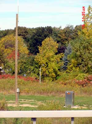
Figure 13-5: Highway Advisory Radio Station Along Freeway
The transmitters and other broadcast components are located in the field. (Figure 13-5) There are multiple technologies available for HAR application.
10-Watt AM Transmission (FCC Licensed)
This is the most common HAR application. When properly maintained and installed, 10-watt transmitters have a broadcast radius of approximately 3–5 miles depending on topography, atmospheric conditions, and the time of day. Frequencies used are generally located at the extreme ends of the AM band using specific frequencies based upon the availability of "holes" in the spectrum left by government and commercial stations. New FCC rules permit HAR to be broadcast on any frequency between 530 kHz and 1710 kHz provided an FCC license is obtained. The FCC rulings have also opened up the former dedicated HAR frequencies, 530 kHz and 1610 kHz, to commercial broadcasting, thereby increasing the potential for interference or possibly the loss of a license.
The characteristics of the broadcast are also affected by the frequency used. The lower ranges of the band (e.g., 530 kHz) are adversely affected by power lines (because of its long wavelength). It also has problems with signal fade, which causes distorted transmission for a reasonable distance along the outer (fringe) areas of the coverage area. Because of this, it is uncommon to find any commercial broadcasters on this end, which is an advantage. On the other end of the spectrum, power lines have less impact on the signal, and a crisper fringe transmission.
Digital Highway Advisory Radio
Digital HAR eliminates many limitations of traditional dial-up systems, and improve quality of messages being broadcast to the traveling public. While dial-up systems typically operate over analog phone lines, advanced computer-controlled systems use digital signal processing to optimize performance.
Compared to traditional dial-up systems, "digital HAR" offers increased speed of message updating, centralized management of multiple stations, enhanced reliability, superior audio quality, ease of operation, and automated event logging. The time required for an operator to update audio at a remote site from the central control unit can be as little as two seconds. This can be accomplished through a simple "drag & drop" operation using a specialized Windows program. A Windows environment also easily allows for control of multiple HAR stations from a single central location.
Digital control provides closed loop operation assuring that messages and commands are received exactly as downloaded. There is no guessing about what is occurring at the remote sites. Analog phone lines typically limit audio bandwidth to about 2.5 kHz reducing the quality of the audio motorists receive on their vehicle radios. If desired, digital messages can be downloaded to remote HAR sites at CD quality provided that FCC imposed bandwidth limitations are satisfied.
Low-Power AM Transmission (No FCC License Required)
Low-power HAR has been developed as a means of tightly controlling the broadcast zone and thereby limiting interference from adjacent zones. Low power HAR differs from the previously discussed 10-watt HAR in that its broadcast radius (per transmitter) is generally limited to 500 feet to 1500 feet. By FCC regulation, each transmitter is limited to a maximum 0.1 watt power input to the final frequency stage, and the total length of the transmission line, antenna, and ground lead can not exceed 3 meters. Whereas this limits its broadcast range, it also provides for a reasonably well-defined area of influence, which, through an inter-connection and synchronizing process, permits upwards of 100 transmitters to be coordinated into larger and well-defined saturation zones. Once a car leaves this broadcast area, the signal quality becomes too weak to be heard. This permits a second zonal configuration to be established nearby, transmitting a different message on the same frequency.
By using this concept, a series of zones all operating on the same frequency, may be established whereby unique site-specific messages may be transmitted to provide condition updates in advance of decision points. Aside from the flexibility provided in establishing multiple message zones, low-power HAR may also broadcast over any available AM radio frequency without the need to obtain additional FCC licensing approval. Though the ability to install a system without FCC approval provides the user with great flexibility in installing a system wherever desired, there is no guarantee that once installed, it will not be interfered with by some future more powerful transmission.
The relatively low signal strength must compete with a variety of obstacles, including overpowering commercial broadcasts, signal skip (particularly at night), and poor signal propagation. These difficulties can be overcome by saturating an area (zone) with multiple transmitters and synchronizing their broadcasts. However, this concept is relatively new and, very expensive as the number of transmitters required is large.
Low-Power FM Transmission (FCC License Required)
LPFM service is available to noncommercial educational entities and Travelers' Information Station entities, but not commercial operations or individuals. Maximum effective radiated power for these stations is 100 watts, and the LPFM stations will not be protected from interference caused by full service stations that make changes to their operations. A construction permit or license is required before construction or operation of a LPFM station can be initiated.
Low-power 100-watt FM transmitters, when installed properly, have a broadcast radius of approximately 3-5 miles depending on topography and atmospheric conditions. 10-watt transmitters have an effective range of 1-2 miles in radius. At present, LPFM licenses are not being issued for HAR. The FCC only opened the application process for frequencies for a short time period. The FCC is non-committal about if and when this technology will again be available for HAR.
13.2.7.2 Deployment Strategies
HAR can be broadcast in two ways: Point or Wide-Area coverage.
- In Point broadcast, a single transmitter is used to broadcast over a given area. This is typically used at diversion points of areas of recurring congestion to notify motorists of queues and congestion. This type of implementation is popular with travelers because the information is specific to them. This is the most common application for HAR, and typically utilizes 10-Watt transmitters. It is the simplest to manage in terms of equipment to maintain.
- Wide Area Broadcast transmits a signal to a larger coverage area using multiple synchronized transmitters. This is an effective strategy when a single message is applicable to a large coverage area, and the coverage area is sufficiently large for a motorist to hear the longer message length. The fact that a long single message, that is pertinent to specific travelers for only a part of the message is indeed a disadvantage. Studies have shown that travelers want brief, specific information, pertinent to their location and situation. They are not likely to listen for long periods of time until their information is broadcast. Technically, synchronization is difficult to accomplish between transmitters because both the time and repeated voice signal must be in sync.
13.2.7.3 Portable and Mobile Systems
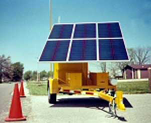
Figure 13-6: Portable Highway Advisory Radio Station
Portable systems permanently installed on trailers and mobile systems installed on service or maintenance vehicles can be of value in providing timely dissemination of information to motorists during short-term deviations from normal highway conditions. This is particularly true in areas where there is limited or no normal coverage or the permanent transmitter site has failed. These systems can be solar powered, generator powered, or battery powered. (Figure 13-6). Portable / mobile systems can be set up at decision points where a route guidance system directs motorist to an alternate route. This will increase motorist comfort level by reinforcing their confidence that they are following the alternate route instructions correctly.
13.2.7.4 Message Distribution
A number of decisions pertaining to the message distribution must be made. One alternative is centralized recording, storage, and playback of messages where transmission lines for audio connectivity and time synchronization with selected transmitters need to be considered. In this alternative, messages are created and stored at a central operations center. The audio is typically retrieved from a digital recorder system and is transmitted via a distribution network to the appropriate HAR controller for radio broadcast. Distribution circuits/lines of this type are commonly referred to as transmission lines because they transmit the actual audio signal to the transmitter. However, the bandwidth on these transmission lines is limited, thereby affecting the quality of the audio signal once it reaches the transmitter site. This quality is further degraded by bandwidth limitations on AM channels. This can be partially corrected by the installation of audio compensation equipment at each transmitter site. In addition to the audio transmission, separate circuits or functionality must be used to control the remote transmitter. This architecture is also subject to single point failures at the central operations center.
A second alternative is distributed recording, storage, and playback where all system functionality is remote to the field HAR station. In this case, data circuits would be used to select the message to be transmitted, control the transmitter, and provide the timing synchronization, if required. A library of standard messages, phrases, and/or individual words are created at, or under the supervision of, a central operations center. The audio information for these "canned" messages is either downloaded into message storage at the HAR site or is transported there and installed in the station's recorder/player. As with central site storage, an ITS central processor could be used to create or select the appropriate message, phrase, or word combinations. Message selection for broadcast, and control of the transmitter controller and digital recorder/player are all done via remote commands from the central site. The type of distribution circuits / lines used are commonly referred to as control circuits because they "control" the remote equipment. Because they must be capable of sending a live message to a transmitter from the central operations center, these lines must also function as transmission circuits when necessary. A distributed storage system is inherently more robust and less vulnerable to single point failures than a centralized system.
13.2.7.5 HAR Signing
HAR signs, indicating the frequency at which traffic information is available, are typically installed throughout each zone. These signs usually include flashing beacons that are activated only when a message of some predetermined level of importance is being broadcast and a legend reading (or similar) "TRAFFIC ALERT WHEN FLASHING." (Figure 13-7) This technique permits the system to continuously broadcast "default" messages in each zone during non-congestion periods, while alerting the motorist to an urgent/emergency message by turning on the flashing beacons, thus preventing motorists from tuning to the HAR frequency only to hear the default message time and time again – situations that could negatively impact system credibility. CMS can also be used to alert the motorist to the broadcast of a message of the utmost importance.
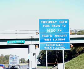
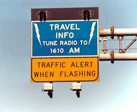
Figure 13-7: Highway Advisory Radio Sign
These signs can be controlled through phone lines, or with cellular or paging technology, and can be solar powered with battery back up. They offer a great deal of flexibility, by allowing only the pertinent signs to be activated. For instance, while two signs (one in each direction) may be associated with a particular transmitter, only one would be activated for a downstream incident, thereby eliminating any loss in credibility by notifying traffic in both directions, one of which, the information is irrelevant.
13.2.7.6 Automatic Highway Advisory Radio (AHAR)
Automatic highway advisory radio (AHAR) provides a method to overcome the need for HAR signing and manual tuning to the HAR frequency. The traveler information is the same as traditional HAR; the automatic part of the system is tuning the radio to the HAR frequency. The AHAR transmitter sends out a leading message, which is picked up by a special in-vehicle receiver when the vehicle enters the AHAR zone. The message automatically tunes the radio to the AHAR station and mutes any regular radio broadcast until the AHAR transmission is complete.
A form of AHAR has been implemented in Europe via the "Radio Data System [RDS] Traffic Management Channel [TMC]". This system relies on a silent data channel broadcast via FM from existing radio stations.
13.2.8 Telephone-based Traveler Information
An in-vehicle communication technology that has seen dramatic growth in the past few years is cellular telephones, which gives the motorist the ability to call special "hotline" systems for traffic information from within their vehicle. Originally, these systems allowed motorists and transit users to call for information to assist in pre-trip decisions from their homes. Information can now be accessed en route via cellular telephone, and decisions can be made whether to alter travel routes. The creation of call-in systems has been a popular traffic impact mitigation strategy for many major urban freeway reconstruction projects in recent years.
This type of in-vehicle communication has the advantage over HAR of giving the motorist some control over the type and amount of information he/she wants to obtain through the touch-tone menus. In addition, it is also possible to generate two-way communication between the motorist and the information source.
Recommendations for establishing cellular telephone-based systems include the following:
- The caller should only be charged for airtime according to his or her cellular calling plan. No additional fees should be charged.
- The telephone number must be easy to remember and dial.
- The information must be concise.
- If a menu system is used, a long and tedious menu selection process should be avoided.
- A sufficient number of telephone lines should be provided to prevent the majority of users from receiving a busy signal.
- If a system is going to be used to gather information from users, there must be a method of ensuring the accuracy of the incoming information.
- "Official" use of tipster information should include procedures for verifying that information.
- If incident information is to be received, a human operator is recommended so that secondary questions can be asked to clarify confusing or unclear reports.
As with HAR systems, this technology also requires action by the motorist to access information. Depending on the users calling plan, there may also be significant operating costs associated with this technology, (as any calls made using cellular telephones must be paid for by either the motorist, or a public agency, or else absorbed by the corporation providing cellular telephone communication capabilities in the region). Finally, there is some concern that cellular telephone usage while driving may degrade motorist attention and operating capabilities. Manufacturers have developed "hands-free" telephones (typically with headsets) that allow motorists to listen and talk without holding the telephone receiver. Moreover, some states (e.g., New York) have adopted a hands-free law requiring operators of motor vehicles to use hands-free assistance when using a mobile phone. Nevertheless, the need to push the telephone buttons to go through a menu of information operations can defeat the "safety" purpose behind hands-free devices, unless the telephone service has voice recognition capability (i.e., saying a number instead of pushing the keypad button).
13.2.8.1 511
Understanding the importance of consistence and simplicity in providing telephone-based traveler information, in1999, the U.S. Department of Transportation (USDOT) petitioned the Federal Communications Commission (FCC) to designate a nationwide three-digit telephone number for traveler information. This petition was formally supported by 17 State DOTs, 32 transit operators, and 23 Metropolitan Planning Organizations and local agencies. On July 21, 2000 the FCC designated "511" as the national traveler information number.
Simply put, 511 is an abbreviated three-digit dialing code; a short cut to a ten-digit telephone number for obtaining traveler information from a telephone. In petitioning the FCC, USDOT had to demonstrate the need and benefits for such a number. To that end, the USDOT identified the following: (10)
- Over 300 telephone traveler information systems in the U.S. could benefit from one such number
- Demonstrated value of traveler information services to the public
- 72% call volume increase N11 vs. easy 7-digit number
- 10-digit dialing makes numbers harder to remember
- Area code expansion making 7-digit numbers less plausible
Further benefits are realized. 511 puts a "face" on ITS and transportation operations, while increasing attention on the potential for traveler information services. With 511, transportation agencies can offer easier access to information via telephone, and have the same number work in multiple places. It is not uncommon for traveler information numbers to change across jurisdictional boundaries, creating confusion among motorists.
A number of issues must be addressed when implementing a 511 service. The following system considerations are taken from the 511 Deployment Coalition's, "511 America's Travel Information Number, Implementation Guidelines for Launching 511 Services", version 1.1, June 2002 (Reference 12):
- System Access Quality: The ability of the telephone system to reliably and quickly answer calls.
- Hours of System Operation: The days and hours that 511 service should be available to callers.
- ADA Implementation: Complying with accessibility laws and regulations.
- Environmental Justice: The relationship of 511 and environmental justice principles that prevent discrimination against minority and low-income populations.
- Standards: 511 and National ITS standards.
- Privacy: Privacy protections for callers.
- 911 Linkage: Relationship of 511 services to 911 services.
- 511 Branding: The creation of a brand identity for 511 services to manage consumer expectations.
- Number Allocation and Service Coordination: Organizing and coordinating transportation agencies in a given region to determine what 511 services will be offered, by whom and in what geographic area(s).
- Inter-regional Interoperability: How 511 services interconnect.
To reduce the potential for service confusion and inconsistency, the 511 Deployment Coalition offers other guidelines for implementing 511 services. The guidelines include: (12)
- Content guidelines that focus on defining the information that should be provided by a basic 511 service. The guidelines recommend that every 511 system deployed in the United States provide at minimum the basic content as defined in the document. It is this basic content that callers will associate with the core of 511. A summary of some possible optional content categories also is provided.
- Consistency guidelines that address steps that implementers can take increase the degree of uniformity and consistency of 511 service across the country. The consistency guidelines cover 15 separate issues, such as user interface, and time stamping of information.
As of the end of 2002, 32 "511" programs have been, or are readying to be, implemented in 27 states. In December 2002, a total of 741,841 "511" calls were received totally over 978,000 minutes of usage. (11). These systems differ greatly, from simplified versions where a live operator answers and responds to all calls of all nature to automated systems where the caller is routed through a menu system to obtain information specific to their travel location. An example is shown in Figure 13-8.
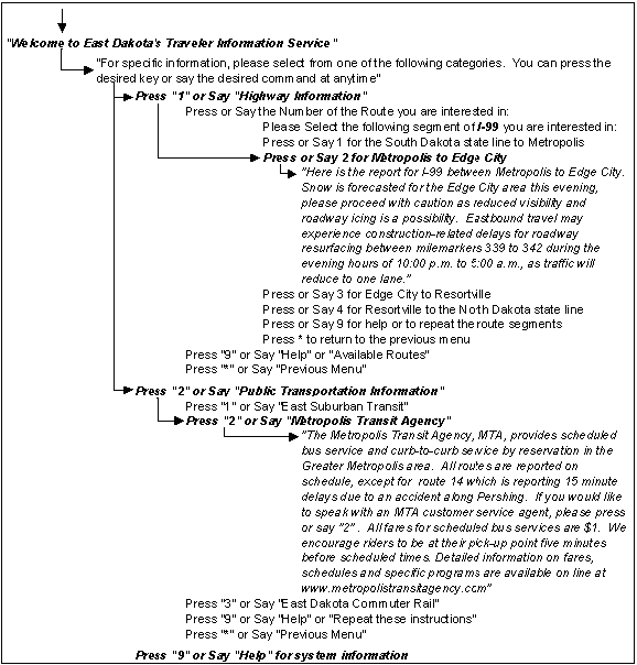
Figure 13-8: Example of a Basic 511 System (Reference 11) D
Additional information on 511 is available from "Resource 511", a repository of information for the 511 deployment community (e.g., marketing ideals, implementation guidelines, evaluation), available at http://www.deploy511.org.
An example of a 511 scheme is "CARS-511". CARS-511 is a road reporting system that utilizes information, which was created within the CARS multi-state database of highway events. CARS-511 provides timely information to travelers who can access this information via a telephone by simply dialing "5-1-1" on the touch pad. Authorized staff use CARS to input construction, accidents, delays, and other roadway, weather and tourism information into state-wide databases, using standard web browser software. CARS servers also support routine DOT dispatch, press release and emergency response activities.
The information entered into CARS is then continuously updated to the CARS-511 system. CARS-511 provides traveler information through a variety of categories including urgent reports, routine reports, road weather and it also provides transfers to outside phone numbers that provide transit-related information. Eight of the ten CARS Pooled Fund States have elected to participate in the CARS-511 initiative. These States are Alaska, Iowa, Kentucky, Maine, Minnesota, New Hampshire, New Mexico, and Vermont. CARS-511 was first launched with the Minnesota DOT on June 30, 2002.
13.2.9 In-Vehicle Devices
13.2.9.1 Commercial Radio
The public has learned to depend upon the media to provide them with "almost" real-time traffic information. Commercial radio has proven to be a good means of providing travelers with traffic information both in and out of their vehicles. Traffic and roadway condition reports have become standard programming items on many commercial radio stations. Commercial radio has the best potential of reaching the greatest number of commuters, since most of them have radios (and listen to them) in the vehicles they drive to and from work.
The primary disadvantage of using commercial radio relates to the accuracy of the information and the level of detail provided. Traffic reports often are transmitted only when normal scheduling permits. Most major metropolitan areas have stations that report traffic every 10 minutes; but the available time is limited, meaning that only the worst situations are reported. Moreover, with other stations, there may be considerable time delays between when an incident occurs and when it is reported. The accuracy of the information provided by commercial radio is a function of the time between the broadcaster's last communication with the incident reporting source and the number of incidents that have occurred and/or have been cleared during that time.
Some transportation agencies have made substantial efforts to improve coordination and cooperation between themselves and the media traffic reporters. For example, some agencies allow private traffic reporting agencies to place personnel in the traffic management center to obtain information on traffic conditions and expected agency responses in an accurate and timely manner. Others means of working with the media include proving the media with real time data feeds, congestion maps, and video feeds.
13.2.9.2 Video Display Terminals
A video display terminal (VDT) mounted in the dashboard, with wireless communications, is another form for providing information to motorists in their vehicles. This is primarily a private sector industry, which has not been used widely for information distribution. These systems can be used to provide motorists with route guidance and navigational information in one of two different formats. One approach is to present the driver navigation and route guidance information in the form of maps or equivalent displays. With these systems, a global picture of the traffic network can be provided. Recommended routes can be highlighted on the video map display as well. In another approach, simple symbolic signals (e.g., arrows, text instructions, or a combination of both) guide the driver along a recommended route. Some systems use a variety of displays depending upon whether or not the vehicle is in motion, the functions selected, and level of informational and navigational displays available.
In-vehicle VDTs offer a number of advantages over available technologies in providing information to motorists while driving. These include the following:
- Travel information is more readily accessible to the driver (providing continuous access to current position, routing, and navigational information).
- Computer-generated navigational maps and displays are logical extensions of traditional forms of providing drivers with route guidance and navigation information.
- Information can be displayed in text, graphics, or both and tailored to the needs and desires of each motorist.
There are also limitations to in-vehicle VDTs. These include the following:
- Drivers have to take their eyes off the roadway in order to receive the information.
- In-vehicle VDTs present the driver with complex maps and diagrams that may create a potential to overload the driver with too much information.
- VDTs may also add to the visual clutter already inside the vehicle.
As technology continues to improve, the Head-Up Display (HUD) has become another alternative to in-vehicle VDTs for presenting visual navigational and route guidance information to motorists. Although originally developed for the aviation industry, several automobile manufacturers are beginning to develop HUDs for presenting vehicle status and navigational information to drivers. A wide variety of options for displaying information may be available using HUDs. Through both icons and alphanumeric text, navigation and route guidance information may be projected directly into the driver's field of view. This is expected to reduce the need for visual scanning between two information sources (the inside instrument panel and the outside environment), and the associated visual accommodation time.
13.2.9.3 Subscription Services
A number of private providers supply traveler information services on-demand as a subscription. Most notably, General Motors' (GM) OnStar is a 24 hours a day, 7 days a week motorist assistance system installed in the vehicle. It provides a wide range of services to the driver including concierge service, telephone service, remote unlocking of the car, notification of air-bag deployment just to name a few. Another feature it provides is route guidance to motorists.
The motorist initiates a call from a button installed in the car, and is connected to a live Onstar operator, and asks for directions. The operator knows the vehicle's location through OnStar's automated vehicle location system, and provides directions for the fasted route. OnStar currently uses third-party wireless analog networks, and is moving to a digital technology, which will allow the service to be expanded to handheld devices as well. 53 current (2003) vehicle models are offered with OnStar, and GM intends to expand to 60 models by the end of 2003. Routing assistance is the most utilized services, and OnStar reports that it handles more than 220,000 routing call per month.
Internet subscription services are addressed in the following section.
13.2.10 Other Methods
13.2.10.1 Television
Television (together with radio) was one of the first off-roadway motorist information technologies available to motorists. Even today, commercial television stations in most major cities provide traffic reports to viewers as part of their morning programs to indicate incident locations, closures, and other traffic "hotspots." These locations are usually shown on some type of wall-mounted or computer-generated map display, often coupled with video images from planes / helicopters, a privately-owned network of cameras, video images from FMS cameras, or some combination. In some instances, the TV reports are broadcast directly from the TMC. Another option is for the cable TV franchise to allow the DOT to provide continuous traffic coverage (e.g., cycling through real time video feeds) during peak periods or throughout the day.
13.2.10.2 Personal Data Assistants (PDAs)
Personal Data Assistants (PDAs) are the next higher level of sophistication in both off and on-roadway information dissemination technology. PDAs are computer products that have enough power to support applications such as time management and handwriting recognition. By adding radio frequency (RF) communications technology, PDAs allow users to interact directly with travel information systems. This interaction allows users to obtain route planning assistance, traffic information broadcasts, and other pertinent information. Through keypad entry, the user can log on to the information system, request pertinent information, and then log off. PDAs offer the user increased communication and information transmission/receiving power over alphanumeric pagers.
13.2.10.3 Computers (Internet & Web Sites)
On-Line services to access the Internet represent an additional means to disseminate pre-trip traveler information. The Internet's effectiveness as a fast and flexible communication medium has spurred explosive growth in all sectors of society. The network is now in daily use by people in all professions.
Most state and many local DOT's have web sites that include traffic information (Note: In general, these can be found at either www.dot.state.xx.us, or www.dot.xx.gov, where "xx" is the state abbreviation, and then clicking on the traffic / construction information links.), with the freeway management system often providing much of the information (e.g., data, maps, video). Several private Information Service Providers also have web sites providing similar information for multiple cities. Many of these sites provide:
- Real-time traffic flow information via color-coded maps
- Road closure information (e.g., for construction or maintenance)
- Real time video images (still captures or streaming video)
- Camera selection.
- Travel advisory information for route planning
- Links to other web sites
- News and weather.
Examples are provided in Figures 13-9 through 13-11. It is worth noting the different legends that are used to describe states of traffic flow and levels of congestion to the traveling public.
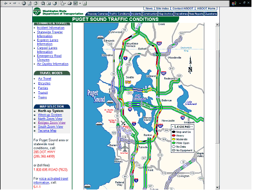
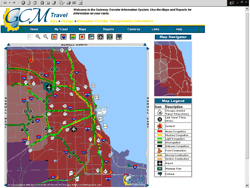
Figure 13-9: Examples of Traveler Information Websites
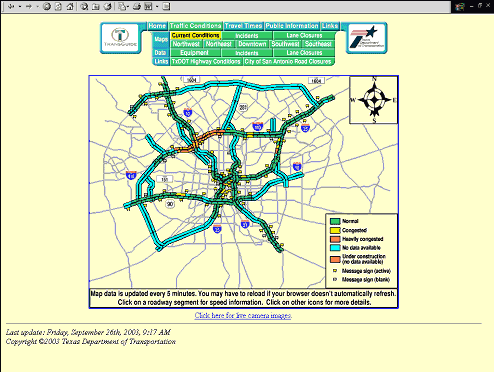
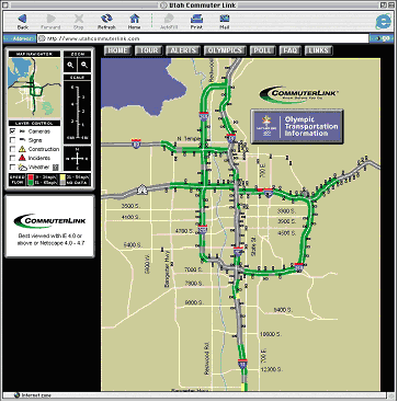
Figure 13-10: Examples of Traveler Information Websites
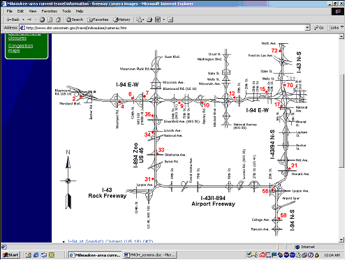
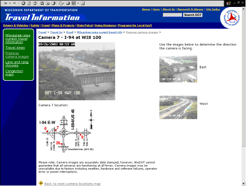
Figure 13-11: Example of Traveler Information Websites (CCTV Selection and Viewing)
Some of the more sophisticated sites provide pre-trip and en-route traveler information with a subscription service (either free, or for a fee, depending on the service) for automated travel advisories via e-mail, pagers / PDAs, or cell phones. When they sign up for the service, subscribers input a travel profile (e.g., primary / alternative routes, times of day) and their choice of device(s) for receiving information. They are then alerted whenever there is an incident or other travel problem on these routes during their travel schedule.