Highway 217 Corridor Study
Study Findings and Preliminary Recommendation
Printable Version (PDF 802KB)
CONTENTS:
- Background and Overview
- Phase II Options and Findings
- Highway 217 Corridor Study Preliminary PAC Recommendation
- Highway 217 Corridor Study Phase II Proposed Timeline - 2005
Background And Overview
Study Purpose
Highway 217 is the major north-south transportation route for the urbanized portion of Washington County. Traffic volumes have doubled in the past 20 years as the county has grown into a booming high-tech and residential center. Peak corridor travel is expected to increase an additional 30 percent during the next 20 years.
Every transportation planning effort that has looked at this part of the region has identified the need for additional capacity on Highway 217.
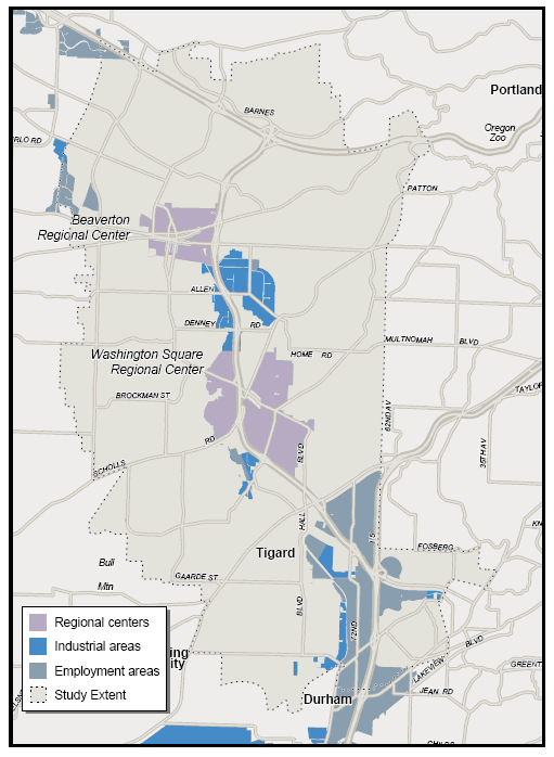
Figure 1. Area of Study
Study goals and objectives
The goal of the Highway 217 Corridor Study is to develop transportation improvements that will be implemented in the next 20 years to provide for efficient movement of people and goods through and within the corridor while supporting economically dynamic and attractive regional and town centers and retaining the livability of nearby communities.
Objectives:
- Provide a proactive, comprehensive and engaging public involvement effort.
- Enhance effectiveness of the transportation system.
- Provide a feasibility assessment of each alternative.
- Support neighborhoods, businesses and the natural environment.
- Ensure that benefits and impacts associated with selected strategies are equitable to minority and low-income communities in the corridor.
- Conduct a conclusive and thorough study with results that can be implemented.
The study, which began in 2003, is a cooperative effort by Metro, Washington County, the Oregon Department of Transportation, TriMet, and the cities of Beaverton, Lake Oswego and Tigard.
Critical issues
- Increased transportation needs have resulted from employment and residential growth in Washington County.
- Highway 217 is the principal north/south access to Beaverton and Washington Square regional centers, fve town centers, and industrial and employment areas in Kruse Way, Hillsboro, Tualatin, and Wilsonville.
- Today’s peak hours of congestion will nearly triple by 2025 (from 2.5 to 8 hours).
- Safety concerns are the result of short distances between interchanges.
- Freight traffc has doubled in the past ten years (8 percent of current traffc volume).
- The cities of Beaverton and Tigard have developed a series of trails, paths and bikeways which need to be linked together to connect regional centers and community resources.
- Pedestrian trails and walks in the corridor have notable gaps that need to be completed.
Policy advisory committee (PAC)
A committee comprised of 20 elected offcials, business representatives and area residents has been providing guidance throughout the study process. Final committee recommendations on options to move forward and other next steps will be presented to regional elected offcials later this fall.
Study approach
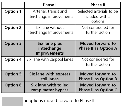
The Highway 217 Corridor Study is being completed in two phases. Phase I developed and analyzed a wide range of multi-modal alternatives in the fall of 2004. Alternatives were evaluated as to how well they addressed the study objectives in terms of travel performance, environmental and neighborhood effects, fnancial feasibility and cost effectiveness. Based on this evaluation, the alternatives were refned to three options that have been studied in more detail. This report summarizes the fndings of the Phase II evaluation, and the preliminary PAC recommendation.
Table 1. Highway 217 Alternatives
Phase II Options And Findings
Key study elements common to all options
Interchange improvements*
Braided Ramps:
- Walker/Canyon
- Beaverton-Hillsdale/Allen
- Scholls Ferry/Greenburg
Split Diamond:
- Allen/Denney
Other:
- Barnes Road
- SW 72nd Ave.
- Hall Blvd.
- Highway 99W
* Potentially preferred interchange designs
Arterial improvements*
Parts of:
- Walker Road
- Cedar Hills
- Canyon Road
- 125th Ave.
- Oleson Road
- Allen Blvd.
- Greenburg Road
- SW 72nd Ave.
- Gaarde Street
- Dartmouth Street
- Nimbus Road
* Included in the RTP Financially Constrained list
Transit improvements
- Bus service enhancements
- Commuter rail from Wilsonville to Beaverton
Bicycle/pedestrian improvements
Parts of:
- Cedar Hills Blvd.
- Watson Ave.
- Beaverton Creek Greenway
- Hunziker Street
- Hall Blvd.
- Multi-use path between I-5 and Hwy. 217
Regional trails improvements
- Fanno Creek Trail (crossing of Hwy. 217)
- Washington Square Greenbelt
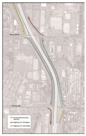
Split diamonds
address the merge/weave conflict by reducing the number of interchanges and connecting them with frontage roads. This solution was applied at Canyon Road and Beaverton-Hillsdale Highway on Highway 217 where access to two streets is combined into one interchange. Drivers entering Highway 217 going north from Beaverton-Hillsdale Highway use a frontage road to enter at the Canyon Road entrance.
Figure 2. Split Diamonds on Highway 217
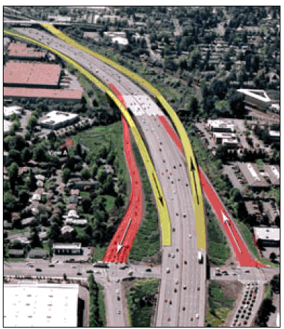
Braided ramps
separate exiting traffc from entering traffc by creating a bridge for vehicles entering the freeway that does not descend to the freeway until it has crossed over the lane of traffc exiting the freeway. In this way, traffc engineers “braid” ramps with some traffc crossing over and some crossing under to prevent accidents.
Figure 3. Braided Ramps on Highway 217
Overall Findings
- Access to regional centers: All options would improve access to regional centers within the study corridor. However, the study has identified a series of north-south arterial improvements that would significantly enhance local access. These include improvements and extensions to portions of Greenburg Road, Nimbus Avenue, Hall Boulevard and SW 103 Avenue.
- Bicycle/pedestrian recommendations: After several months of study, meetings with the bicycle/pedestrian community, and an open house, a series of bike lane and multi-use trail improvements were identified to complete a north-south route about a half-mile west of Highway 217. Bicycle/pedestrian recommendations are included in all options. Overall findings.
- Transportation opportunities/limitations: All options include intersection improvements that significantly improve both the flow and safety on Highway 217. All of the options currently under consideration draw more traffic to the bottleneck on I-5, south of Highway 217.
- Freight: Highway 217 is a critical connection for the movement of goods and services from and to industrial areas in Hillsboro and Tualatin and to the centers of Beaverton, Tigard, Lake Oswego and Washington Square. All of the options provide time savings for trucks. The general purpose lane options provide overall congestion relief for all vehicles. The express toll lane offers the most benefits to small trucks who were assumed to have access to a fast and reliable trip on the toll lanes. The tolled ramp meter bypasses offer benefits to small and large trucks who could pay to bypass the queue.
Base case: In the evaluation of all multi-modal portions of this study, the Base Case assumed the current 4-lane highway design and existing intersections evaluated with 2025 levels of residential and employment development. It also includes arterial and transit service improvements which are anticipated to be built by 2025.
Level of study analysis: Approximately one to three percent of actual engineering for each option has been completed. More detailed design and environmental analysis is needed before a final alternative can be selected and built.
Funding considerations: Due to a lack of state transportation funds available, funding considerations have been a major focus of the study. State and regional policy requires every major project to consider tolling. In the proposed options, tolls are a "user fee" charged only to people who use the new tolled lane and/or ramp meter bypass. Other funding options have been and will continue to be considered. Due to the large funding gaps and the size of the project, a phased project is likely.
Phasing of construction: Given traditional funding amounts, a combination of interchange reconstructions and arterial street improvements could be made prior to the construction of new through lanes on Highway 217. Making these improvements first will address some immediate congestion and safety problems and will assist in reducing construction disruption. If additional funds become available, the project could be constructed in geographic segments. Priority interchange improvements include Beaverton-Hillsdale, Allen and Denney. The earliest completion date has been calculated to be 2014, however this assumes an immediate start to a preliminary engineering/environmental impact statement as well as securing funding.
Equity for all users: Results from other tolling projects around the country indicate that all income groups use and favor an express toll lane, although it is used more often by those in higher income groups. With a tolled lane, everyone has travel choices including using the regular (untolled) lane, driving on the tolled lane at a reduced fee during less congested times of the day, carpooling to share the fee and taking transit.
Congestion is greatest during traditional commuting hours (early morning and late afternoon). Studies of existing tolling projects show that higher income drivers tend to travel more during these peak hours. Unlike a peak toll, the gas tax requires everyone to pay the same fee, even if they are traveling during uncongested hours.
Option A – Six Lanes
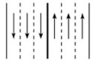
Overview: This option would include an additional travel lane in each direction that will be open to all traffc on Highway 217. Like all options, includes substantial interchange improvements to resolve merge and weave conficts which create safety and congestion problems.
- This option offers the most overall congestion relief and fastest average drive times for all drivers on Highway 217 (saves 3 minutes over base case).
- Wetland impacts: approximately 2.8 acres.
- Largest funding gap – capital cost $523 million with an estimated funding gap of $504 million (in 2014).
- Without supplemental revenues, estimated construction completed in 2089.
- Overall congestion relief benefts all trucks.
- Public acceptance: prefer ease of general purpose lane but concerns about projected construction timeline with traditional funding sources.
Option B – Six Lanes With Express Toll Lanes
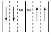
Overview: This option would include a rush-hour toll lane in each direction in addition to the existing lanes of Hwy 217. Drivers would be able to enter and leave the express lane at I-5 and US 26 as well as at one intermediate point between the Washington Square and Beaverton regional centers. Tolls would be collected electronically without requiring stopping at a tollbooth. It also includes bypasses of ramp meters for toll lane users. Express bus service has been provided to take advantage of time savings on toll lanes and ramps.
- Fastest travel time in toll lanes (saves 8.5 minutes over base case).
- Saves travel time in general purpose lanes (saves 1 minute).
- Express trip incentive for transit and carpools.
- Wetland impacts: approximately 3.2 acres.
- Smallest funding gap – capital cost $581 million with an estimated funding gap of $332 million (in 2014).
- Without supplemental revenues, estimated construction completed in 2028.
- Small trucks access toll lane and all trucks use ramp meter bypasses.
- Public acceptance: more acceptable as funding mechanism but reservations about complexity and feasibility of tolled facilities and about equity for all users.
Option C – Six Lanes With Tolled Ramp Meter Bypass
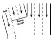
Overview: This option would include an additional unrestricted travel lane in each direction on Highway 217 in addition to a new lane on the entrance ramps. Drivers who choose to use the new express ramp lane to bypass the queue at the ramp meter would pay a toll. Trucks would be allowed to use the bypass lanes. Express bus service has been provided to take advantage of time savings on toll lanes and ramps.
- This option offers the most overall congestion relief and fastest average drive times for all drivers on Highway 217 (saves 3 minutes over base case).
- Wetland impacts: approximately 2.8 acres.
- Signifcant funding gap – capital cost $540 million with an estimated funding gap of $449 million (in 2014).
- All trucks can access ramp meter bypasses.
- Without supplemental revenues, estimated construction completed in 2042.
- Public acceptance: limited toll revenue and negative perception of ramp bypass concept reduces the attractiveness of this option.
Note: All capital costs are in 2005 dollars.
Figure 4. Comparison of the Costs, Travel Time, and Delay of the Different Options for Improving Highway 217.

Summary of Key Findings
Table 2. Summary of Key Findings

For more detailed information on key findings, see the following reports: "Transportation Performance Report", Metro, July 27, 2005, Memo: "Phase II - Potential Environmental Impacts", Metro, August 26, 2005, Memo: "When Could Highway 217 Alternatives Be Built with Traditional Funding?", ECONorthwest, August 29, 2005, "Phase II Public Involvement Summary", Metro, September 2005
Highway 217 Corridor Study Preliminary PAC Recommendation
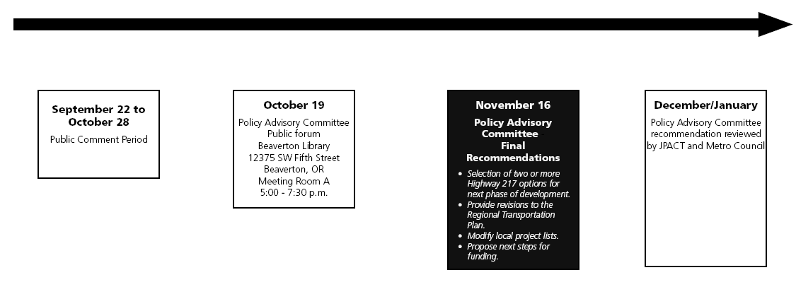
The Highway 217 Policy Advisory Committee approved the following preliminary recommendation for public review on September 21, 2005. After considering public comments, the PAC will make a final recommendation in November. The final PAC recommendation will be forwarded to JPACT and the Metro Council for approval. Conclusions from corridor studies are drawn without the level of engineering analysis and detailed environmental analysis that is completed as part of an Environmental Impact Statement (EIS). The EIS would be the next logical step for many projects identified or proposed in this document.
Overall Recommendations for Regional Consideration
The PAC recognizes that the region needs additional transportation funding and supports efforts to increase funding at federal, state and local levels.
Due to the large funding gaps under all options, in the near term, seek higher funding priority for Highway 217 improvements at federal, state and local levels.
- ODOT, Metro and local jurisdictions should seek to amend the list of Highways of Statewide Significance to include the Highway 217 project. In terms of construction cost, volume of freight and commuter travel, congestion and importance to the economy, Highway 217 appears to be comparable to other facilities on the list of statewide priorities.
- ODOT, Metro and the local jurisdictions should include priority interchanges or other appropriate elements of the Highway 217 project in any state, regional or local transportation funding measures.
- ODOT, Metro and local jurisdictions should consider seeking a federal earmark for Highway 217 in the next federal transportation reauthorization.
Seek long term solution to the congestion on I-5 south of the study area.
- In the near term, commence a corridor study of the section of I-5 between Highway 217 and Wilsonville. The Highway 217 study highlighted the severity of the future bottleneck at this location. Each of the options worsened this bottleneck, particularly Options A and C, which drew the most new traffic to the corridor.
Highway 217 Traffic Lanes
Summary conclusion
The evaluation found that congestion within the corridor will increase from three to eight hours a day if no improvements are made over the next twenty years. There is a need and support for a new through lane in each direction south of Canyon Road on Highway 217.
- The general purpose lane (Option A) offers the most overall congestion relief and the fastest average drive time on Highway 217. However, it is anticipated to have the largest funding gap in 2014.*
- The express toll lane (Option B) offers some overall congestion relief and the fastest travel time on Highway 217 for toll lane travelers. It offers an incentive for carpool travel and possible transit and would have the smallest funding gap in 2014.*
- The general purpose lane with ramp meter bypass (Option C) has similar travel benefts as the general purpose lane, but projections show limited revenue potential – approximately one-third that of the express toll lane option in 2014.*
Public comments were much more negative about Option C (the tolled ramp meter bypasses option). There was a perception that the ramp meter bypasses are unfair and that people will respond negatively to those who travel on them. The public reaction to the general purpose and express toll lane was much more positive. Many people preferred the traditional general purpose lane to the tolled lane from a transportation perspective. However, due to concerns about the potential timeline for improvements for the general purpose option and the sense that tolling is a fair way to pay for improvements (i.e. those that benefit pay for it), most people expressed support for further study of the toll lane.
*Based on currently anticipated funding sources.
Recommendations
All of the options improve transportation performance on the corridor. The PAC recommends that the general purpose and express toll lane options be carried forward because of greater public acceptance and the importance of keeping potential financing options open. The tolled ramp meter bypass option should not continue as a separate option due to lack of public acceptance, limited potential revenues and the lack of projected usage for many of the tolled ramp meter bypass locations. Tolled ramp meter bypass locations that have potential should be evaluated further in the EIS process as part of the tolled lane option.
Highway 217 Interchanges
Summary conclusion
Due to the close spacing of interchanges and the growth in traffic volumes, major interchange improvements are needed to avoid serious congestion and safety problems on the highway and adjacent intersections. None of the interchanges meet current highway spacing standards and interchange improvements are necessary to meet level of service standards in 2025.
Recommendation
In the short term, the PAC recommends further developing and evaluating the following interchange improvements as part of a National Environmental Protection Act (NEPA) process (along with other appropriate options). The following list provides a general order of priority for the recommended interchange improvements, but implementation of these projects should respond to funding opportunities and local transportation needs and could occur in a different order. Engineering and specific design of the improvements should be evaluated in the NEPA process.
First Tier Priority
- Beaverton-Hillsdale/Allen Blvd. ramp braids
- Allen/Denney Road split diamond interchange
Second Tier Priority
- Canyon/Walker Road ramp braids
- Scholls Ferry/Greenburg Road ramp braids
- Greenburg Road (major interchange improvement possibly single point interchange)
Third Tier Priority
- SW 72nd Avenue (additional turn lanes with major interchange improvement — design to be determined)
- Barnes Road (widening with additional turn lanes)
- Progress Interchange (interchange improvements including widening and additional turn lanes)
- Highway 99W (revised access lanes to/from Highway 217, widening and additional turn lanes)
Arterials
Summary conclusion
The arterial improvements in proximity to the corridor in the RTP Financially Constrained System are critical for access to regional centers. These are listed on page four of the Phase II overview report. The evaluation also identified a series of north-south arterial improvements and extensions to Greenburg Road, Hall Boulevard, Nimbus Avenue and SW 103rd Avenue, which support the corridor travel needs. While these are not part of the recommended Highway 217 options, the north-south arterials significantly enhanced local access to regional and town centers, reduced congestion on Highway 217 and were better at reducing congestion than a package that also included several east-west arterial improvements.
Recommendation
In the short term, design and construct the arterial improvements within the financially constrained plans. The PAC recommends that local jurisdictions identify the following north-south improvements as priorities in their Transportation System Plan process. These projects are:
- Greenburg Road Improvement (RTP 6031) — widens to 5 lanes from Tiedeman to Highway 99W.
- Nimbus Avenue Extension (RTP 6053) — a two-lane roadway extension from Nimbus to Greenburg.
- Hall Boulevard Extension (RTP "I") — a new five-lane arterial north of Center Street to connect with Jenkins Road at Cedar Hills Blvd.
- 103rd Avenue (RTP 6012) — improve existing roadway on SW 103rd and construct new intersection alignments to provide a connection from Western Avenue to Walker Road.
- Nimbus Road Extension (RTP 3037) — a two-lane roadway extension of Nimbus Road from Hall Boulevard to Denney Road.
- Hall Boulevard Improvement (RTP 6013 and 6030 North) — widen to 5 lanes from Scholls Ferry Road to Highway 99W.
Bicycle and pedestrian facilities
Summary conclusion
The study found a need for a north-south route to the west of Highway 217. A series of bikeways have been planned on the west side of Highway 217 in the cities of Beaverton and Tigard; however, several portions of that bikeway have not been constructed. The completion of the bikeway trails would provide a continuous route to the west of Highway 217.
Additionally, there is a recognized need to provide a route for the Fanno Creek Regional Trail where it crosses Highway 217 (between Denney Road and Allen Blvd.). Phase I considered a trail underneath Highway 217. However this is not desirable due to seasonal flooding and safety issues. Therefore, improvements should be made to the Denney over-crossing or a separate overpass should be provided. A connection of the Washington Square Greenbelt is also needed. Both of these projects will be included in future studies and are included in all alternatives considered in the Phase II evaluation.
Recommendation
The PAC recommends that priority be given to the following projects that complete a north-south route:
- Cedar Hills Blvd. Improvement (RTP 3075) — Butner Road to Walker Rd.
- Hall Blvd. Bikeway (RTP 3046) — Beaverton-Hillsdale Hwy. to Cedar Hills Blvd.
- Watson Ave. Bikeway (RTP 3047) — Beaverton-Hillsdale Hwy. to Hall Blvd.
- Hall Blvd. Bikeway (RTP 3074) — gap at Allen Blvd.
- Nimbus Ave. Extension (RTP 6053) — replacement for Cascade Blvd.
- Hunziker St. (new project) — Hall Blvd. to 72nd Ave.
- Multi-use path (new project) — I-5 to SW 72nd Ave.
- The pedestrian path/walk improvements on all improved viaducts crossing Highway 217 and a bicycle/pedestrian connection over Highway 217, or associated with the over crossing improvements on Denney Road, to the Fanno Creek Region Trail; and a connection to the Washington Square Greenbelt trail.
Transit service
Summary conclusion
Peak hour commuter rail service between Wilsonville and Beaverton was assumed in all options. This and other transit improvements in the financially constrained system are needed to provide travel options and reduce congestion. Express bus service assumed to be provided on Highway 217 in the tolled alternatives attracted good ridership and achieved significant time savings over existing planned service.
Recommendation
The PAC recommends continued increases in transit service in the corridor study area over the next twenty years per the RTP. Express bus service on Highway 217, expanded commuter rail service, and other appropriate transit service increases should be examined as part of future RTP updates and in the EIS process.
Highway 217 Corridor Study Phase II Proposed Timeline - 2005
More information and an online survey is available at www.hwy217.org.
Public input is important to this process. Please send comments or requests for information by e-mail to trans@metro.dst.or.us or call Metro Transportation Planning at (503) 797-1757.
You may need the Adobe Acrobat Reader to view the PDFs on this page.
