I-30 Little Rock to Benton, Arkansas
In 1999, Arkansas decided to undertake the rehabilitation of over 50 percent of their Interstate highway infrastructure. As a result, in 2000 the Arkansas Highway and Transportation Department (AHTD) began rehabilitation and re-construction on more than 350 miles of roadway. The AHTD also looked at tools to help mitigate the potential impacts from construction.
Most relevant to the study of ITS in work zones are the three work zones that utilized ITS to improve traffic safety and mobility during the time of construction. Specifically, one of the three Arkansas projects using ITS included the widening of approximately 17 miles of I-30 from Sevier Street in Benton (mile marker 115) to Geyer Springs Road in Little Rock (mile marker 133). A key portion of the work zone is shown in Figure 16. The primary objective for using ITS in this location was to improve the safety of travelers by providing advance warning of slowed traffic or congested downstream conditions.
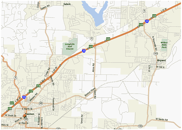
Figure 16. Arkansas I-30 Work Zone Location
Study Site Work Zone
Prior to the beginning of construction, this 17-mile section of I-30 had an Annual Average Daily Traffic (AADT) of 63,000 vehicles. In 2001, as documented by the Highway Performance Monitoring System, sections of this stretch of I-30 experienced greater than 20 percent truck traffic. According to personnel at AHTD, there is an average of approximately 40 percent truck traffic during the day, which increases to 75 percent at night. The large volumes of truck traffic created the potential for large work zone impacts due to their size and impact on mobility.
The AHTD administered construction in this area for seven projects including widening the Interstate to six lanes, removing and replacing the concrete roadway, reconstructing nine interchanges, installing a concrete barrier wall in the median, and converting all of the frontage roads to one-way. The seven projects that made up this extensive work zone were as follows:
- I-30 from Sevier St. to West of Alcoa Road (from mile mark 115.7 to 119.6) – This project included widening the roadway to six lanes, removal and replacement of the existing concrete, installation of a concrete barrier wall in the median, and conversion of frontage roads to a one-way direction. Completed: Winter 2004.
- I-30 at the Hwy. 5 Crossover – This project included bridge work at the crossover. Completed: March 2003.
- I-30 at the Alcoa Road Interchange (at mile mark 120.7) – This project included removing and replacing the existing interchange. Completed: Spring 2003.
- I-30 west of Alcoa Rd. to west of Pulaski Co. line (from mile mark 119.6 to 125.6) – This project included concrete reconstruction and widening to six lanes, modification of the Bryant/Reynolds Road interchange, ramp relocations, installation of a concrete barrier wall in the median, and conversion of frontage roads to a one-way direction. Completed: Spring 2005.
- I-30 at the Mabelvale West Interchange (at mile mark 128) – This project included removing and replacing the existing interchange. Completed: Summer 2003.
- I-30 from west of the Pulaski Co. line to I-430 (from mile mark 125.6 to 129.7) – This project included concrete reconstruction and widening to six lanes, modification of the Alexander interchange, ramp relocations, installation of a concrete barrier wall in the median, and conversion of frontage roads to a one-way direction. Completed: Summer 2005.
- I-30 between I-430 and Geyer Springs Road (from mile mark 129.7 to 133) – This project included concrete reconstruction and widening to six lanes, modification of Baseline Road, Mabelvale Pike and University Ave. interchanges, ramp relocations, installation of a concrete barrier wall in the median, and conversion of frontage roads to a one-way direction. Completed: Winter 2005.
ITS Description
To improve the safety of travelers, the AHTD installed an Automated Work Zone Information System (AWIS) covering the entire I-30 Little Rock to Benton work zone corridor. AHTD procured the system from a vendor through the construction contract and leased the system for the duration of its use.
The complete system of monitoring equipment for the I-30 smart work zone included 47 vehicle detector sensors, 4 radio transmitters, 15 dynamic message signs (DMS), and 8 stationary video cameras mounted on trailers in and around the work zone. Figure 17 illustrates the location of the various work zone sensors and message signs. Equipment on Highway 5 and Interstate 430 also served to inform motorists when they were approaching a construction area. After detecting a change in Interstate traffic speeds, the AWIS system evaluated its own accuracy by performing a system check of other sensors. Within approximately 5 minutes, computers determined whether one of nine levels of severity warranted communication with the message boards and radios to report the situation. When the sensor system detected significant delays, flashing beacons on HAR alert signs advised motorists entering the broadcast area that the message was "Urgent When Flashing, Tune To 1490 AM."
While the roadside message boards and radios required the 5-minute relay time, sensor-recorded traffic speeds transmitted almost instantaneously to the Web site (www.arkansasinterstates.com). Web site visitors were able to see a complete view of traffic conditions throughout the work zone (see Figure 17). Color-coded roadway segments (green, yellow, red) between sensors indicated whether traffic was flowing, slowed, or stopped. Hovering the mouse over any of the equipment icons called up a live video image or displayed the text and audio messages motorists were receiving on the road.
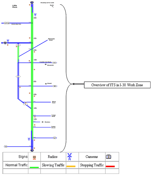
Figure 17. Overview of I-30, Little Rock to Benton, Arkansas Work Zone[1, 2]
Measures and Metrics
The main areas of evaluation for this work zone encompassed the following: safety, user perspectives, mobility, and productivity.
To evaluate these primary areas of interest, the study team developed the following 11 hypotheses:
- The use of ITS in the work zone will reduce travelers' exposure to hazard.
- The use of ITS in the work zone will enhance the safety performance of the highway.
- Travelers will use the work zone ITS.
- The use of ITS in the work zone will improve trip planning.
- The use of ITS in the work zone will improve traveler tolerance of work zone delays.
- The use of ITS in the work zone will improve the confidence of travelers driving in the work zone.
- The ITS information will be readily understood by users.
- The use of ITS in the work zone will improve incident response and clearance times.
- The use of ITS in the work zone will divert travelers to alternate routes during times of work zone congestion.
- The use of ITS will improve the productivity of contractors and travelers.
- The ITS will be reliable and accurate.
The study team used the following information sources to assess the hypotheses:
- Private vehicle driver surveys (a copy of the survey is provided in Appendix A).
- Commercial vehicle driver surveys (a copy of the survey is provided in Appendix B).
- State Police personnel interviews.
- Construction manager interviews.
- Traffic counts (using tube data and Remote Traffic Microwave Sensor data).
- System detector data.
- Personal experience from the study team site visits.
- Crash data were reviewed but were not feasible to use for this study, as explained in the relevant hypothesis below.
The study team used the driver surveys to asses 8 of the 11 hypotheses. A description of how the surveys were administered is provided in Appendix C. The survey responses were coded in a database and checked for consistency using statistical analysis software.
A total of 297 commercial vehicle drivers (CVD) and 319 private vehicle drivers (PVD) participated in the surveys. Of these, 286 CVD and 306 PVD surveys were suitable for further analysis. The 24 surveys that were not used were discarded due to incomplete responses pertaining directly to the ITS devices. The following section presents the findings of the analyses pertaining to each hypothesis. Appendix D includes statistical test summaries for each of the survey questions.
Findings
Hypothesis 1: The Use of ITS in The Work Zone Will Reduce Travelers' Exposure To Hazard
The objective of the study team was to study this hypothesis using a combination of data obtained from a review of crash records, and from surveys of police personnel, private drivers, and commercial drivers.
To answer this hypothesis using crash data, the study team contacted the Arkansas State Police (ASP) to obtain crash records for I-30 from two time frames: after the establishment of the work zone but before the ITS and after the establishment of the work zone and with the ITS. The objective of the study team was to determine if there was a statistically significant reduction in the number of crashes from the period with the work zone and no ITS to the period with the work zone and with the ITS – indicating a decrease in travelers' exposure to hazard. Unfortunately, crash data were only available in the originally recorded hard copy accident data collection forms. Furthermore, in developing an analysis approach based on the crash records, it was determined that the complexity of the work zone phasing and configuration would throw any results into question. Hence, based on the high cost associated with converting and analyzing these data, coupled with the multiple compounding factors noted at this work zone, this means of analysis was infeasible. The following list summarizes the major compounding factors encountered that may have impacted the potential to develop a sound safety analysis:
- Prior to implementing the work zone on I-30 in Arkansas, the frontage/service roads were two-way frontage roads. These would possibly impact any safety analysis, as I-30 exits directly to the frontage road in many instances.
- Following implementation of the work zone but prior to the ITS, the first stage of construction was the rendering of two-way frontage roads into one-way frontage roads. This may have skewed the data because it may have contributed to accidents by confused drivers.
- Following the conversion of the frontage roads, the full work zone was put in place along with the ITS. The layout of the work zone included two lanes of traffic bounded by concrete Jersey barriers with minimal to no shoulders, potentially also impacting the safety performance of the work zones.
- Throughout the frontage road conversion process and the design and re-design of the work zone over the various phases of construction, the on- and off-ramp configurations changed repeatedly. In some instances, a full stop was required before entering the highway; in others, just a yield. In many cases, there was limited roadway length for acceleration.
- The work zone included multiple pavement cuts. In some instances, steel plates covered the pavement cuts resulting in possible safety degradation due to an uneven roadway surface.
- The concrete Jersey barriers did not have adequate drainage. According to AHTD personnel, heavy rains caused water to channel between the barriers and accumulate on the roadways, thus potentially impacting safety during weather events.
Consequently, the study team addressed this hypothesis using the survey responses to questions aimed at gauging whether the drivers felt safer and whether they were better prepared to react to hazards or delays. To determine this, two survey questions about the DMS were asked of the private and CVDs on I-30. See Appendices A and B for the survey questions and the scale for responses used in the survey.
In total, 292 PVDs and 263 CVDs responded to the question "Because of the info on the signs I am better prepared to react to slow or stopped traffic." The average rating for PVDs was 1.76, and for CVDs was 1.68 (where 1 is completely agree and 2 is somewhat agree). These numbers indicate that with the electronic messages the drivers felt better prepared to react to slower traffic. In fact, 82 percent of the PVDs and CVDs combined (457 drivers) agreed with this statement. A single sample one-tailed t-test with 95 percent confidence showed that the drivers do agree that the electronic message signs better prepared them to react to slow or stopped traffic (see Tables in Appendix D for statistical summaries for each question).
The second question, which asked the driver to indicate whether or not the DMS makes them feel safer in the construction zone, had positive responses, but not at the same level as the first question. The 292 PVDs and 263 CVDs that answered the second question had an average rating of 2.80, which is slightly more agreeable than neutral (neutral equaling 3). The average rating for the PVDs alone was 2.81 and for the CVDs alone was 2.78, which indicates similarity in the two populations. As illustrated in Figure 3, 49 percent (274) of the 564 drivers that used the DMS indicated that the DMS made them feel safer in the construction zone, 17 percent were neutral, 32 percent disagreed, and 2 percent did not answer this question (See Figure 18). A t-test showed that the drivers do agree that the DMS made them feel safer traveling through this construction zone.
These results may indicate that the DMS are indeed reducing driver exposure to hazard by making 82 percent of roadway users feel better prepared to react to slow or stopped traffic. This result should, however, be carefully considered in light of the finding that about half of the respondents (49 percent) actually feel safer as a result of the DMS.
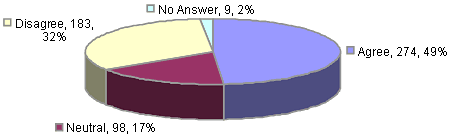
Figure 18. Distribution of Driver's Opinions on the Statement "DMS Makes Drivers Feel Safer in the Construction Zone" (Private & CVDs)
Hypothesis 2: The Use of ITS in the Work Zone Will Enhance the Safety Performance of the Highway
Initially, the study team planned to use crash records to quantify the safety performance of I-30 with and without ITS. However, as indicated in Hypothesis 1, the crash data remained in the originally recorded hard copy accident data collection forms and was not cost effective to collect, organize, and use for this research.
To answer this hypothesis, interviews with State police personnel and construction project management personnel were conducted to determine whether those people most closely tied with the work zone felt that the ITS was improving safety. The following are their responses to the given questions regarding the safety level of the work zone with the ITS.
Interview Conducted with Arkansas State Police Personnel 9/27/04
On September 27, 2004 the Site Coordinator for this project conducted an interview with a Captain in the Arkansas State Police who is familiar with the work site.
1. In your opinion, has the ITS on I-30 improved your incident response capabilities?
- Yes.
1a. Explain
- At times, CCTV (closed circuit television) can be used to view the work zone. Also DMS is a big help in diverting traffic during an incident. It is better than a patrol car.
1b. Please provide examples:
- Faster response time – If traffic couldn't be diverted with the DMS, the only way the responding officer could access the incidents on the I-30 work zone was to use the frontage road to get close, then climb over the New Jersey barrier to get to the scene.
- Faster clearance time – Since the traffic is already diverted, startup after clearance is quicker.
Interview Conducted with Project Management Personnel
In June 2004, the study team conducted an interview with the project management personnel in charge of overall activities of the construction project.
- Do you feel the ITS had an impact on the safety of the construction workers (in the work zone)?
- Yes.
- If so, how?
- Gives early warning to motorists about lane shifts.
- Could you provide examples?
- They had to shift traffic onto the frontage roads three times in a short period and the message boards helped them control the traffic.
- Do you feel that the ITS affected the number of crashes in the work zone?
- Yes, it helped slow down traffic.
- Do you feel that the ITS affected the severity of crashes?
- Yes, it helped slow down traffic.
- Do you think the ITS helped the authorities in their ability to respond to these incidents?
- No, I do not think the police used the information from the CCTVs.
From these interviews, it is evident that the people working within the construction zone feel that the ITS has improved the safety of both the workers and the travelers. Some components of ITS, such as CCTV, can be further utilized for incident management in work zones. It is interesting to note that the police directly stated that the CCTV was useful, while the contracting personnel did not believe that the police were using that technology. This may indicate the need for better communication between work zone stakeholders.
Hypothesis 3: Travelers Will Use the Work Zone ITS
This third hypothesis addresses whether or not the travelers on I-30 used the available work zone ITS. For this particular work zone, three primary ITS components helped users determine if they should use I-30 or an alternate route. These were as follows: Arkansas' Pave the Way Web site (www.arkansasinterstates.com), DMS throughout the work zone, and the highway advisory radio (HAR) station. The surveys asked participants if they had used/seen/heard each of the ITS components. The following question was used to obtain ITS usage rates for this section of interstate: "Do you use any of the following sources to get information about traffic conditions on this section of I-30?" Some of these sources, such as CB radio, local radio, and television, were not part of the ITS.
As shown in Figure 19, drivers of both private and commercial vehicles used DMS most often, followed by the sources of information that are not considered ITS, such as television, local radio, and CB radio. A great majority of respondents (~95 percent) used the DMS in the work zone. This is explained by the fact that the signs are on display throughout the work zone and the user does not have to invest any time to locate or use the DMS. Approximately one quarter (24 percent) of the drivers on I-30 have used the HAR, and about half of those drivers felt that the broadcast quality was too poor to hear properly, which could indicate why the usage is so low.
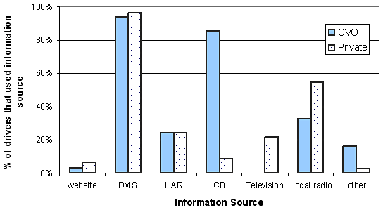
Figure 19. Distribution of Sources Used to Get Information about Traffic Conditions on I-30
Approximately 7 percent of private drivers and 3 percent of CVDs reported that they had used the ITS Web site. Of these people (23 respondents in total), 38 percent had only used the site once (usually out of curiosity). Despite this low usage rate it is interesting to note that of all the people surveyed (592 combined PVDs and CVDs), 24 percent of the drivers (142 respondents) reported that they had heard about the Web site. This indicates that 80 percent of the people that had heard about it had not used it. The most common responses as to why the person did not use the Web site were: they did not care, did not have the time, or were "too lazy." The study team examined the characteristics of the drivers who visited the Web site. The average age of this group was similar to the average age of the non-Web users (80 percent falling between the ages of 26-55 with the largest single category being those drivers aged between 36 and 45). The study team did not perform additional statistical analysis due to the small number of drivers who visited the Web site. In addition to the survey results, the activity of the arkansasinterstates.com Web server was analyzed to determine the extent of usage. The Web site activity is stored in two servers operated by AIM Hosting Services; the first server records the non-camera image contents, while the second is dedicated to the camera image content. The period of time for which the information from both servers was available was August 16, 2004, to September 15, 2004. On average, 200 users visited the Web site 350 times each day as illustrated in Figure 20. About 68 percent of the visitors used the Web page only once per day. On average, 40 people per day visited the camera contents. As a whole, these 40 users loaded about 100 pages (each page being an image at a certain location) on a daily basis.
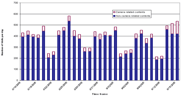
Figure 20. Activity in Work Zone Webpage Servers (8/16/2005 was a Tuesday)
The average visit length during the analysis period was about 30 minutes, indicating that users likely had some interest in the Web page content. The most active hours on the Web site were from 8 a.m. to 9 a.m. and from 5 p.m. to 6 p.m.—showing interest in work zone traffic appeared during peak periods.
The servers also contained data related to the location of the visitors. About 36 percent of the site visits identified in the U.S. originated from Arkansas, followed by visits from the states of Virginia (32 percent) and Texas (5 percent). The remaining visits included a distribution across all other states and unidentified locations.
These findings help support the hypothesis "Travelers will use the work zone ITS." The findings indicate that DMS are heavily used, HAR is moderately used, and a minimal number of the surveyed drivers use the Web site.
Hypothesis 4: The Use of ITS in the Work Zone will Improve Trip Planning
This hypothesis addresses the trip planning benefits that users may experience as a result of the ITS. The study team examined the hypothesis by analyzing the responses to survey questions pertaining specifically to each of the three ITS components (Web site, DMS, and HAR). The questions differed by ITS component, as did the findings.
Web Site
The two survey questions used to determine if the Web site improved trip planning were: "For what reasons do you use the I-30 Web site?" and "The info on the Web site improves my ability to avoid delay on this section of I-30."
In response to the first question, out of all of the drivers included in this study (592), six drivers (1 percent) said that they do use the Web site to plan the route they would take, and two drivers (0.3 percent) said they use the Web site to plan the time they would start the trip. Note that this percentage is consistent with the statistics garnered from the Web site servers. Given the AADT of 63,000 and the average number of Web users (200), the usage percentage comes out comparable at .3 percent. Narrowing the scope of the analysis to the 26 drivers who use the Web site, 7 were CVDs and 19 were PVDs. Out of the 7 CVDs and the 19 PVDs, 2 CVDs (29 percent) and 4 PVDs (21 percent) answered that they used the Web site to plan the route they will take, and 2 private drivers (11 percent) said they use the Web site to plan the time they would start the trip.
From these 26 drivers, 23 also responded to the second question involving the Web site's ability to improve trip planning. On average, drivers responded with an average level agreement of 2 (2 indicating that they somewhat agree). A t-test with 95 percent confidence level showed that the 23 drivers agree that the Web site was able to improve trip planning. From these two survey questions, one can infer that the Web site had a low usage, but its few users believed the Web site helped them in trip planning.
DMS
To determine if users readily understood the DMS, the study team studied the responses to the following three questions:
- "Has the information on the signs ever caused you to exit this section of I-30 to find an alternate route?"
- "The messages are detailed enough to help me make decisions about my route."
- "The signs are located in the right places to help me make decisions about my route."
Two hundred fifteen CVDs and 239 private drivers responded to the first question. Of these respondents, 20 percent (44) of the CVDs and 50 percent (120) of the PVDs said that the signs have caused them to change their route. The low number of CVDs that responded positively is most likely due to the fact that truck drivers do not have very many alternate routes, as heavy vehicles are only allowed on certain roads. During the interviews, the CVDs made it clear that in most cases, once they had taken a route, it was too late to change it regardless of the traffic. A PVD can take any exit available.
In response to the other two questions, on average, both CVDs and private drivers indicated that they somewhat agree that the signs are detailed enough and are located in the correct places for a different route to be taken if there is significant delay. Using a t-test with 95 percent confidence, drivers indicated that they agree that the DMS contain enough detail and are located in the correct places.
Considering the agreement of drivers in response to these questions, and the fact that 50 percent of the private drivers who answered the first question said that they have used the DMS for advisories as to whether to stay on I-30, there is some indication that DMS in the work zone assisted in providing drivers with the information required to make routing decisions. The effectiveness of DMS on trip planning depends on how far upstream the messages are delivered. This is especially true for commercial vehicle travel.
HAR
The study team used the responses from two questions to assess the utility of HAR. These two questions are: "Have the highway advisory radio messages ever caused you to exit this section of I-30 to take an alternate route?" and "The messages are detailed enough to help me make decisions about my route."
For the first question, 17 CVDs out of 286 (6 percent) and 30 private drivers out of 306 (10 percent) said that they had taken an alternate route due to the HAR. Similar to the responses related to the DMS benefits, a lower percentage of CVDs used the HAR to make decisions about their route.
The average rating for the second question was 1.93, indicating that the drivers agreed (1 is completely agree; 2 is somewhat agree) that the messages were detailed enough to help them make decisions about the routes. The same trend described in the previous question holds in this case, where more private than commercial drivers agree that messages are detailed enough to make decisions about their route. However, with the low number of users, it is difficult to say whether the HAR is improving trip planning.
Hypothesis 5: The Use of ITS in The Work Zone Will Improve Traveler Tolerance of Work Zone Delays
To answer this hypothesis, responses were reviewed from the following survey question: "Just having the information makes me feel less bothered by the delays in the construction zone." This question applied to two components of the ITS: the DMS and the Web site. For the DMS, both PVDs and CVDs were asked to rank their agreement with the stated question. For the Web site, only private drivers were asked. For both the Web site and the DMS, responses averaged a "neutral" or "somewhat disagree" level of agreement with the given statement. Figure 21 shows the distribution of responses for the DMS. Figure 22 presents the distribution of the responses from the private drivers for the Web site.
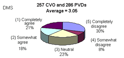
Figure 21. Distribution of Responses to the Statement, "Just Having The DMS Information Makes Me Feel Less Bothered By The Delays In The Construction Zone."
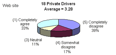
Figure 22. Distribution Of Responses To The Statement, "Just Having The Web site Information Makes Me Feel Less Bothered By The Delays In The Construction Zone."
Although the average rating for the participants was neutral, about 39 percent of drivers (215 drivers) agreed that having the information on DMS made them feel less bothered in driving through the construction zone. The DMS messages were general in terms of traveler/delay information (e.g. specific travel times were not posted) and changed based on speed thresholds. They also posted specific mile-marker information. For the Web site, 6 of the 18 drivers (~33 percent) agreed that the information on the Web site made them feel less bothered in driving through the construction zone.
Hypothesis 6: The Use of the ITS in the Work Zone Will Improve the Confidence of Travelers Driving in The Work Zone
To determine if ITS improves traveler confidence, the responses to the following questions were used: "Because of the info on the signs, I am better prepared to react to slow or stopped traffic" and "I feel safer traveling through this construction zone because of the electronic messages." Both CVDs and private drivers received these questions, but the questions pertained only to DMS (not the Web site or HAR). DMS was the focus of this question because once in the midst of the work zone, DMS is the only form of ITS immediately accessible; it does not require internet or a radio. These questions also served to partially answer Hypothesis 1 (the use of ITS in the work zone will reduce traveler's exposure to hazard) because drivers' confidence and drivers' exposure to hazard are closely related. As discussed in Hypothesis 1, a t-test with 95 percent confidence showed that the drivers agreed that the DMS better prepared them to react to slow or stopped traffic and made them feel safer traveling through the construction zone. Assuming that drivers feel more confident when they are better prepared to stop or slow down, the evidence presented here supports the hypothesis under investigation.
Hypothesis 7: The ITS Information Will Be Readily Understood By Users
Survey questions for each of the three components of ITS (Web site, DMS, and HAR) served to answer the given hypothesis for drivers of both private and commercial vehicles on I-30. The two questions differed for the different components of ITS, as did the findings. Each of the components will be discussed separately to answer this hypothesis.
Web Site
The responses the drivers gave to the question requesting level of agreement with the statement "The Web site is easy to use" served in the study of whether drivers readily understood the Web information. Twenty-four drivers answered this question, and twenty-three of them agreed that the Web site was easy to use. The 24th driver (a CVD) gave a neutral answer to this question, which may be due to the driver only visiting the Web site once. With overwhelming agreement of the few Web site users surveyed (24), one can conclude that the Web site is easy to use.
DMS
The responses to two questions served to address the seventh hypothesis pertaining to DMS. These two questions requested a ranking of agreement with the statements "The messages are easy to understand" and "The messages are detailed enough to help me make decisions about my route."
About 94 percent of CVDs (269 drivers) and 96 percent of PVDs (295 drivers) said "yes," they had used the DMS. Of these respondents, 261 CVDs and 287 private drivers responded to both questions. The drivers who responded to both questions strongly agreed the messages were easy to understand. They gave an average rating of 1.26, where 1 means completely agree and 2 means somewhat agree. They also agreed that the messages were detailed enough to help them make decisions about their route. The average rating for this question was 1.78. Both of these findings were significant at a 95 percent level. These findings indicate that the DMS messages were easy to understand and that the DMS were detailed enough to help drivers to make decisions about their routes.
HAR
The responses to the following two questions facilitated the study of Hypothesis 7 pertaining to HAR. These two questions requested ratings of the statements: "The radio broadcast quality is too poor to hear properly" and, "The messages are detailed enough to help me make decisions about my route."
About 24 percent of CVDs (69 drivers) and 24 percent of PVDs (74 drivers) said "yes," that they had used the HAR. Of these respondents, 60 CVDs and 64 private drivers responded to both questions. Of these combined 124 drivers, the average response to the quality of the broadcast was 2.57 (where 2 means somewhat agree and 3 means neutral). However, the drivers did agree that the messages were detailed enough to help them make decisions about their route. The average rating for this question was 1.93. Both these findings were significant at a 95 percent level. From this, one can conclude that about half of the people who would like to use the HAR can hear the broadcast clearly. When they could hear it, the broadcast was understood and detailed enough on average. Perhaps the proper course of action would be to increase the signal strength so more people who would like to use the HAR are able.
Hypothesis 8: The Use of ITS in The Work Zone Will Improve Incident Response and Clearance Times
Incident response and clearance times with and without ITS in the work zone could not be used for comparison because the data were unavailable. To answer this hypothesis, an interview with police personnel was used to determine if the police department felt that the incident response and clearance times improved due to the ITS. The following are the interview responses.
Interview Conducted With a Captain and a Dispatcher at the Arkansas State Police
The Captain indicated that the ITS on I-30 improved their incident response capabilities. He explained that at times, CCTV could be used to view the work zone. He also noted that the DMS is a big help in diverting traffic during incidents; it was better than a patrol car. The Captain provided the following examples:
- Faster response time – If traffic couldn't be diverted, the only way the responding officer could access the incidents on the I-30 work zone was to use the frontage road to get close, and then climb over the New Jersey barrier to get to the scene.
- Faster clearance time – Since the traffic is already diverted, startup after clearance is quicker.
The interviewer also spoke with a radio dispatcher working with the state police who suggested some improvements to the ITS. The interviewer summed up the dispatcher's comments with the following statement:
The dispatcher preferred to see live images of the work zones. The dispatcher had to "refresh" the image anytime she needed to see what was going on. This occurred whenever a cell phone call reporting an incident was received. Work zone images were of limited value because the actual crash site was not always in the image. The dispatcher would have preferred to have more cameras or to have pan, tilt, zoom (PTZ) abilities so they can focus on the crash site.
It was also said that the CCTV could help determine what emergency vehicles needed to respond to incidents. However, given the camera image quality and standard operating procedures, the police said a trooper had to actually be on the scene to make this determination. They may believe this because they do not have PTZ ability that would allow them to most effectively use the CCTV.
These were some suggestions to further improve the ITS utility to the state police. From these responses, it can be seen that the State police department does feel that the ITS in the work zone somewhat improves response and clearance times; however, effective and efficient response could be greatly improved by the addition of greater camera functionality.
Hypothesis 9: The Use of ITS in the Work Zone Will Divert Travelers to Alternate Routes During Times of Work Zone Congestion
To answer this hypothesis vehicle counts were taken at six exit ramps, DMS message records were collected for 15 message boards, and mainline volume counts were collected for I-30 at each of the off ramp locations (see Figure 23 and Table 15). The study team collected these data over a 4 day time span between Monday, May 17, and Thursday, May 20, 2004. The goal was to correlate the off-ramp volumes and mainline volume data with the messages displayed on the upstream DMS.
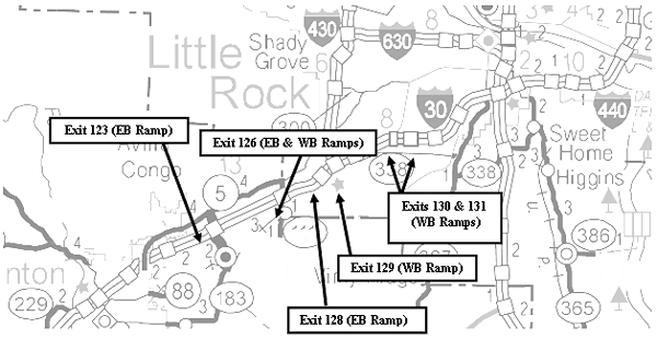
Figure 23. Location of Ramps Used for Hypothesis No. 9[3]
| Message Board ID | Highway | Direction | Mile Marker |
|---|---|---|---|
| S01 | I-30 | EB | 111 |
| S02 | I-30 | EB | 114 |
| S03 | I-30 | EB | 116 |
| S04 | I-30 | EB | 118 |
| S05 | I-30 | EB | 122 |
| S06 | I-30 | EB | 126 |
| S07 | I-30 | EB | 128 |
| S08 | I-30 | WB | 136 |
| S09 | I-30 | WB | 128 |
| S10 | I-30 | WB | 126 |
| S11 | I-30 | WB | 123 |
| S12 | H-5 | EB | |
| S13 | H-5 | EB | |
| S14 | H-5 | WB near 430 | |
| S15 | I-430 | EB |
Unfortunately, the data sets contained large gaps in the data and much of the message board and exit ramp data was unusable because the DMS were too far from the ramps to assume that the drivers reading the boards would exit at the given ramp. After combining the useable data, the only data left was from four off ramps (eastbound exits 123, 126, and 128; westbound exit 126), each with an average of 2 days of consecutive data, including one upstream DMS and the corresponding mainline volume counts. Over the full useable data set, there were 12 separate instances when ramp volumes were available and the DMS (at eastbound exits 123, 126, and 128; westbound exit 126) displayed "Delays Possible" messages. Seven of the 12 cases happened during the peak a.m. or late afternoon, and the other five cases occurred during the night (when there were lower volume counts).
From this data there was not enough evidence to suggest a relationship between the DMS messages and diverting traffic. For example, on May 17, 2004, the DMS upstream of the eastbound ramp at exit 128 displayed delay messages for short periods of time, while volumes on ramp fluctuated from 10 to 36 vehicles in a 15-minute period. While on May 17 the DMS message remained the same, the ramp volume fluctuated by a factor of three. On May 18 and May 19, ramp volume fluctuated with a similar magnitude but no delay messages were displayed. Thus, the data did not indicate a clear association between ramp traffic volume and the display message.
In examining the peak a.m. cases, large volumes of traffic exited I-30 at the same time the DMS were displaying "Delays Possible." It would seem that the messages were, indeed, diverting traffic. However, these diversions could easily be due to normal trip planning; the exiting travelers may have been planning on getting off at the given exit regardless of the traffic conditions. Given these confounding factors, more data is needed to answer the hypothesis "The use of ITS in work zones will divert travelers to alternate routes during times of work zone congestion."
Hypothesis 10: The Use of ITS Will Improve the Productivity of Contractors and Travelers (Both Private and Commercial)
This hypothesis includes two sections: improving productivity for contractors and improving productivity for travelers. To address the section on travelers the survey data were used. The survey questions used for this hypothesis were the same as Hypothesis 4 and, consequently, results for these two hypotheses were the same. The following are the conclusions from Hypothesis 4:
- Web site – It has the potential to improve the productivity of travelers. Even though the servers show a stable number of daily visits, the Web site usage among the surveyed drivers was very low.
- DMS – They appear to be improving the productivity of travelers.
- HAR – It appears to be improving productivity for those drivers who use it.
To answer the question of improving productivity for contractors, a separate questionnaire was developed. The work zone project contract manager responded to this questionnaire during an in-person interview. The questionnaire contained four questions applicable to this hypothesis; two of these were direct questions and two were indirect.
The two indirect questions were "Do you feel the ITS had an impact on the safety of the construction workers (in the work zone)?" and "Do you feel the ITS helped you or your subcontractors to carry out the construction?"
For the first question the response was: "Yes…Gives early warning to motorists about lane shifts. They had to shift traffic onto the frontage roads three times in a short period and the message boards helped them control the traffic." For the second question, the interviewee agreed that the ITS helped carry out the construction for planning and implementing lane closures, and planning and implementing alternate routes, but not for planning for and changing on-and off-ramp configurations. These questions add insight to the situation but do not answer the question posed.
The two direct questions were, "Did the ITS have a negative impact on any of your operations?" and, "Do you feel that the ITS improved your productivity (or your subcontractor's productivity) by helping you complete the work?"
For the first question the answer was yes, there were negative impacts caused by the ITS. The interviewee stated, "The portable CCTV got in the way of construction operations and the contractor had to have them moved." For the second question the answer was no, the ITS did not improve productivity. He commented, "The message boards were spread out too far to be a big help." The results indicated that ITS in the work zone may not directly improve a contractor's productivity but may help them indirectly to manage the work zone better.
Hypothesis 11: The ITS Will Be Reliable and Accurate
The study team relied on two data sources to answer this hypothesis: 1) traffic volume data collected by the ITS were compared to AHTD maintained RTMS traffic volume data to verify the ITS accuracy, and 2) survey data were used to determine if drivers found the ITS reliable and accurate.
To verify the accuracy of the ITS traffic volume counts, AHTD collected the traffic volume data for the period from May 21 to June 20, 2004, which was compared to corresponding data archived by the ITS. Each of the two databases had some missing sections of data. Days with missing data were removed to prevent a biased selection of hours (night or day hours). In all, the data used represented 10 full days between June 2 and June 16. A total of 240 hourly volume pairs were analyzed for both eastbound and westbound volume counts along I-30. Figure 13 shows the detector location at Raymar Rd.
The study team compared volumes from detectors number 62 and 26 (from ITS) to the I-30 volumes AHTD collected at Raymar Rd. overpass (Figure 24). Note that the distance between the overpass and location of the ITS sensors was not substantial and no point of exit occurred within that distance. For the 10-day period, the ITS-counted eastbound traffic volume (detector 26) was 543,606 and the AHTD-counted volume was 407,046 vehicles. For the same period, the ITS-counted westbound traffic volume (detector 62) was 604,242, and the AHTD-counted volume was 437,026 vehicles. The ITS-counted volumes were 34 percent higher for eastbound traffic and 38 percent higher for westbound traffic than the AHTD volumes. The ITS eastbound and westbound volumes combined were 36 percent higher than the combined AHTD volume. A t-test showed that the combined volume from the ITS detectors was significantly different with a 95 percent confidence level. These findings suggest that the westbound ITS detector was tallying additional traffic (perhaps part of the eastbound traffic) and the eastbound ITS detector was tallying additional traffic (perhaps part of the westbound traffic) at these locations.
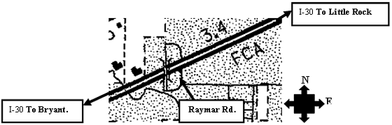
Figure 24. Locations of Detectors Used for Hypothesis 11[4]
Additionally, a comparison was made between the data from the ITS detectors (numbers 63 and 25) neighboring the detectors in question and the AHTD data at the Raymar Rd. overpass. Results showed an average underestimation of 64 percent for eastbound volumes and overestimation of 65 percent for westbound volumes by the ITS detectors. However, the ITS eastbound and westbound volumes combined were less than 1 percent lower than the AHTD data. A t-test showed that the combined volume from the ITS detectors was not different than the AHTD data with a 95 percent confidence level.
The data collected by AHTD served as the reference volume because the eastbound and westbound daily volumes and the volumes over the whole study period were similar. The volumes on both directions are expected to be similar at this location because the work zone is located within a populated area where local drivers travel in both the eastbound and westbound directions. In addition, intercity drivers would use I-30 in both directions without a significant bias toward one direction.
To determine the impact of this calibration on the messages that users would see, a study of the corresponding DMS data was undertaken. The study team also compared messages displayed on DMS located on the eastbound at mile post 122 (called S05) to the speed, volume, and occupancy data collected at ITS detectors 25 and 26 to determine if there was a correlation. The comparison showed that the displayed messages did not match the data from detector 25, but there was some correspondence between the messages and the data from detector 26. For example, when the vehicle count at detector 26 was about 3300 vph and the average speed dropped below 40 mph, the sign displayed the message: "slowing traffic ahead, at mile marker 123, delays possible." It is reasonable to expect similar volumes at detectors 25 and 26 due to their proximity. Thus, the traffic conditions at detector 25 should similarly correspond to the displayed messages. However, the vehicle counts at detector 25 never exceeded 1338 vph in the 10-day-period and so did not trigger the above mentioned messages.
Similarly, the study team compared messages displayed on the DMS located on the westbound at mile post 126 (called S10) to the speed, volume, and occupancy data collected at ITS detectors 62 and 63. The data showed that the displayed messages did not correspond to the data from the detectors. Detectors 62 and 63 indicated significant changes in traffic conditions, with fluctuations on vehicle counts from 1000 vph to 4000 vph and average speeds from 55 mph to 40 mph. But, the displayed message on the DMS during the whole 10-day period was: "Buckle Up, Drive Safely, Caution Trucks Entering And Leaving The Roadway."
Based on these comparisons, the study team concluded that while the combined volume from ITS detectors 25 and 63 was similar to the volume from AHTD, the directional volumes were significantly different. For ITS detectors 26 and 62, the combined volume was significantly higher than the AHTD volume. As a result, it seems that the ITS detectors were not counting the directional volumes accurately at these locations during the analysis period. Whether the detectors were working accurately at other time periods or the detectors at other locations were working properly is not known because no reliable reference data is available for comparison. It should also be noted here that the configuration of the work zone was very complex and the ITS sensors were often operating in areas with minimal room for adjustment. As a result, the sensors could "cross-shoot" lanes if not properly readjusted to the work zone layout.
To perform additional analysis regarding the perceived accuracy of the system, survey questions for each of the three types of ITS (Web site, DMS, and HAR) were asked of the PVDs and CVDs on I-30. All of the questions were "rate-your-agreement"-style questions. The questions differed for the different components of ITS, as did the findings. Each of the components will be discussed to answer this hypothesis.
Web Site
The response to the following question requesting a level of agreement with the statement "The info on the Web site is accurate" served to determine if the Web site was giving accurate information as perceived by the users. The average rating of the 24 drivers who answered this question was a 1.7. This value falls between completely agree (1) and somewhat agree (2). Using a t-test with 95 percent confidence, the drivers agreed that the Web site was giving accurate information.
DMS
The responses to the following question requesting the ranking of agreement to the statement "The messages are accurate" served to assess the accuracy of the messages given by DMS. Ninety-four percent (269) of CVDs and 96 percent (295) of private drivers responded "yes" to using DMS. Of these respondents, 256 CVDs and 287 private drivers responded to the question regarding the accuracy of the signs. The average rating of these combined 543 drivers to the DMS message was 1.75. Performing a t-test for the responses shows that the drivers found the DMS messages accurate at a 95 percent significance level. These findings support the conclusion that participants feel the DMS were giving accurate messages.
HAR
The responses from three questions were used to assess the utility of HAR. These three questions requested participants to rank their level of agreement with the following statements, "The messages are useful," "The messages are accurate," and "The messages are updated frequently enough."
Twenty-four percent (69 drivers) of CVDs and 24 percent (74 drivers) of PVDs responded "yes" to using HAR. Of these respondents, 60 CVDs and 56 private drivers responded to all the three questions stated above. Of these combined 116 drivers, the average response to whether the messages were useful was 1.74 (a rating higher than for "somewhat agree"). The average response to the accuracy was 2.0, or somewhat agree. The average response for whether or not the messages were updated frequently enough was 2.27, or somewhat agree. Using a t-test at 95 percent significance showed that the drivers agreed that HAR was useful, accurate, and updated frequently enough.
The specific statistical summaries for each set of survey question responses can be found in Appendix D.
Summary of Findings – Arkansas
The analysis presented in this report represents multiple sources of data, analysis methodologies, and outcomes. The following Table presents a summary of the findings for each hypothesis including comments on the analysis.
| Hypothesis | Findings | Comments |
|---|---|---|
| The use of ITS in the work zone will reduce traveler's exposure to hazard. | Drivers agree that the ITS in the work zone reduced their exposure to hazard. | A large percentage of the surveyed drivers (82%) agreed that the ITS system improved their ability to react to slow or stopped traffic A large percentage of surveyed drivers (49%) agreed that they felt safer traveling through the work zone because of the electronic messages, 17% were neutral, 32% disagreed, and 2% did not answer. |
| The use of ITS in the work zone will enhance the safety performance of the highway. | The police officer and construction manager in the work zone agreed with this hypothesis. | People working within the construction zone feel that the ITS has improved the safety of both the workers and the travelers. |
| Travelers will use the work zone ITS. | Travelers used the components of the ITS that were most available. The highly-used DMS were present in the work zone making them readily available to drivers to read. HAR was used moderately. The Web site had a low utilization among the surveyed drivers | DMS was observed by 95% of surveyed drivers. HAR was used by 24%. Web site was used by 5%. |
| The use of ITS in the work zone will improve trip planning. | Web site: Improves trip planning, but the usage among the surveyed drivers was very low. | The Web site does improve trip planning, but only 5% of surveyed drivers used it. On average, 350 daily visits were registered in the Web site from August 16 to September 15, 2004. |
| DMS: Improves trip planning for PVDs, but has a lower impact for trucks. | DMS in the work zone improve trip planning for PVDs (50% agreement). CVDs have a fixed route and DMS are less effective for trip planning. | |
| HAR: Some of the people who used it improved their trip planning. | 24% of drivers used the HAR to improve their ability to plan their routes. | |
| The use of ITS in the work zone will improve traveler tolerance of work zone delays. | ITS improves tolerance for at least some drivers. | About 1/3 of the drivers said the use of ITS make them feel less bothered in the construction zone. |
| The use of the ITS in the work zone will improve traveler confidence driving in the work zone. | The DMS improve traveler confidence for most drivers. | Drivers' confidence is increased because their ability to react to slow or stopped traffic is increased, and they feel safer driving through the construction zone. |
| The ITS information will be readily understood by users. | Web site: Readily understood. | With almost unanimous agreement, one can conclude that the Web site is easy to use or readily understood by users. |
| DMS: Readily understood. | Information is easy to use and detailed enough for the majority of the I-30 users. | |
| HAR: Understood by only those who could hear the broadcast clearly. | Increase the signal strength so that more people can use the HAR. | |
| The use of ITS in work zones will improve incident response and clearance times. | ITS assists professionals with incident response and clearance times. | ITS does help improve incident response and clearance times; however, it can be improved to enhance its utility. |
| The use of ITS in work zones will divert travelers to alternate routes during times of work zone congestion. | Not enough data to state any findings. | Data were collected for 7 off ramps and 15 DMS over 4 days; however, conclusive findings were not found. |
| The ITS will improve the productivity of contractors and travelers. | Contractors: ITS does not improve productivity, but ITS does help manage the work zone better. | ITS had some negative impacts on construction operations (portable closed circuit video unit got in the way) and did not improve productivity, but using the ITS system for traffic management helped manage the work zone. |
| Travelers: ITS improves motorists' ability to plan their trips. | The Web site had a low usage (5%), but its few users believed the Web site helped them in trip planning. | |
| The ITS will be reliable and accurate. | Drivers felt that the Web site was accurate. | The Web site gives accurate information, but its use is very limited by surveyed drivers (5%). |
| DMS are accurate enough for the majority of the users. | Most drivers (79%) felt that the DMS messages were accurate. | |
| Drivers felt that HAR was useful, accurate, and frequently updated. | Of the 24% of drivers who use HAR, 81% said the HAR is useful, accurate, and updated frequently. | |
| Directional volume counts by work zone ITS differed significantly from data collected by AHTD. | At one location, traffic volume was overestimated by 34% on the eastbound and overestimated by 38% on the westbound direction. A second set of detectors revealed an underestimation of 64% on the eastbound and overestimation of 65% on the westbound. |
Tips and Lessons Learned
Deployment Tips and Lessons Learned
Work zones are highly variable environments. As a result the ITS must be similarly flexible. For example, the work zone examined here was large, complex (included 7 separate projects by 2 contractors), and had a constantly changing configuration. As a result, the calibration of the ITS became a major issue requiring one full-time employee working long hours to maintain all sensors.
ITS is only one part of a successful work zone. The aim of outfitting this work zone with ITS was to improve safety. While there is some indication that the ITS system reduced travelers' exposure to hazard and made the work zone safer, fatal crashes in the I-30 work zone were not fully avoided. ITS can be a valuable part of effective work zone management, but other safety and mobility strategies should also be used as part of a coordinated transportation management plan (TMP).
The recognition of system requirements by all parties affiliated with the work zone and ITS deployment is key. For example, the emergency dispatchers' use and requirements for the system are very different from those of the contractors. A more detailed study of user requirements coupled with revised operating procedures may enhance the system's capability to improve safety and mobility.
Advertising the Web site to a greater audience in various media is important. This is especially true given the high level of satisfaction experienced by the work zone ITS Web site users in comparison to the low level of the number of users.
Evaluation and Research Tips and Lessons Learned
Obtaining crash records can be more difficult than presumed. The lack of existing electronic crash records in a maintained database rendered several of the safety hypotheses infeasible for study by any means other than user surveys and interviews.
Development of a data collection plan should include some forecasting or methodology to accommodate data providers or key stakeholder personnel that may be retiring. For example, difficulties experienced in obtaining police records were compounded by the retirement of the police chief.
Data collection activities should be coordinated as closely as possible with the construction contractors. For example, tubes in place to collect ramp volume data had to be moved before the end of the designated collection period due to construction on the selected ramp.
- Map depicting work zone layout courtesy AHTD.
- U.S. Geological Survey, from "The National Atlas of the United States of America. General Reference," 2001. Map courtesy of the Perry-Castañeda Library Map Collection at The University of Texas at Austin, <http://www.lib.utexas.edu/maps/us_2001/arkansas_ref_2001.jpg> (August 1, 2005).
- Map courtesy of the Arkansas Highway and Transportation Department Map Planning Section (http://www.arkansashighways.com/maps/2004%20state%20highway%20map/statehwymap3-8-04_state.pdf).
- Note: occupancy in this case is a measure of vehicle density in the lane.
You will need the Adobe Reader to view the PDF on this page.
Previous | Next