I-40 Winston-Salem, North Carolina
Over the past several years, the North Carolina Department of Transportation (NCDOT) has undertaken several construction projects involving the deployment of ITS technologies to help mitigate the impacts to traffic. NCDOT sought to alleviate work zone issues such as back-of-queue crashes and traffic delays caused by capacity reductions and movement of materials and trucks to and from work sites via open travel lanes. NCDOT has successfully deployed several ITS systems in different work zones across the state. Benefits from those early deployments included enhanced real-time information for motorists on downstream conditions, better trip planning through information dissemination via Web sites, as well as no fatal crashes.
In early 2004, NCDOT designed an ITS system for a work zone shown in Figure 25 on Interstate 40 west of Winston Salem. The goal of the ITS system was to monitor conditions and improve mobility and safety through the work zone along I-40 between the NC 801/I-40 interchange in Davie County and the SR 1101/I-40 interchange in Forsyth County.
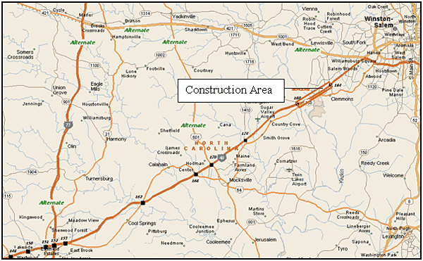
Figure 25. I-40 Work Zone and Signed Alternate Routes
Based on predetermined delay and travel time thresholds, the system provided real-time delay information and, if delays exceeded 25 minutes, recommended alternate routes via dynamic message signs (DMS).
The main objectives of the system were to:
- Reduce demand and congestion (by actively diverting traffic).
- Provide delay information to warn motorists of slowed traffic ahead.
- Provide information to commuters and DOT personnel via a Web site.
- Build public confidence in real-time traveler information.
The main objectives of the evaluation were to:
- Determine traveler response to the work zone information.
- Determine the effect of traveler response on traffic conditions.
- Verify that the work zone ITS functioned as designed.
Study Site Work Zone
NCDOT installed the work zone between milepost (MP) 180 and MP 184, west of Winston-Salem. This section of I-40 is a four lane divided rural Interstate that has Annual Average Daily Traffic (AADT) of 48,000 vehicles per day. NCDOT set up lane closures in each direction in order to rehabilitate pavement and replace deteriorating concrete slabs.
NCDOT began construction on March 23, 2004, with three phases of work. In Phase I, NCDOT milled and paved shoulders and set up off-peak lane closures. In Phase II they replaced concrete slabs and implemented contract provisions allowing for 72-hour lane closures. In Phase III they closed lanes for paving operations and restricted work to nighttime hours. They also planned to perform concurrent bridge painting/maintenance work on I-40 approximately 5 miles east of the work zone. Due to schedule changes, they performed the work later in the summer after Phase III was completed. NCDOT also had to modify the original system configuration to account for the bridge painting/maintenance project.
Generally, the construction contract did not permit lane closures Monday through Friday between 6 a.m. and 9 a.m. (eastbound) and between 4 p.m. and 7 p.m. (westbound) as part of a strategy to lessen impacts to traffic. However, the contract permitted lane closures during Phase II (slab replacement) for up to 72 hours for concrete curing. The contract prohibited lane closures during special events or on holidays.
ITS Description
NCDOT designed the ITS system to monitor traffic conditions within and in advance of the work area from each direction. The system components included:
- A central base station equipped with processing software and wireless communications to link the system components.
- 10 portable DMS remotely controlled via the central computer base station.
- 10 portable traffic sensors linked to the central computer base station.
NCDOT designed the system as shown in Figure 26. They re-mobilized it several times throughout the summer, and used an alternate configuration later in the deployment for the separate bridge painting project with weekend lane closures. NCDOT procured the system using a special provision through the prime construction contract.
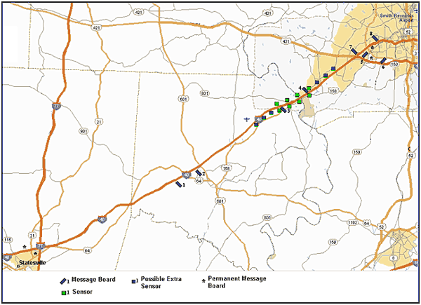
Figure 26. I-40 Smart Work Zone Deployment Near Winston Salem
NCDOT designed the system to provide real-time operational status of the work zone via the central base station computer and via the Internet on a dedicated project Web site. They also designed it to notify the appropriate personnel, by pager and email, when a malfunction occurred in the system or once the delay through the work zone exceeded 25 minutes. They programmed the system to display appropriate messages and alternate route information via the DMS when warranted.
Each traffic sensor communicated with the computer base station to activate the appropriate DMS whenever the prevailing traffic speed slowed to 55 mph. Once the system activated, it automatically displayed the preprogrammed delay messages in real-time on the DMS. NCDOT designed the system to calculate, via simple algorithms, real-time delay for display on the portable DMS. The system calculated delay and displayed information on the portable DMS to the nearest minute for delays up to 15 minutes after a 5-minute delay was observed. For delays exceeding 15 minutes, the system displayed information on the DMS rounded to the nearest 5-minute increment. The system posted updated delay information every minute. The Web site updated delay information simultaneously with the information displayed on the DMS.
For westbound traffic, the system encouraged motorists to take 421 west from Winston-Salem, and then to take either 601 south or I-77 south to rejoin I-40. For eastbound traffic, the system encouraged motorists to take 601 north at exit 170, then 421 east to rejoin I-40 at Winston-Salem. NCDOT formally signed these alternate routes prior to construction. Motorists familiar with the area may have also deemed US-158 a possible alternate route. However, US-158 is a two-lane highway that runs parallel to I-40 and was not a preferred alternate route due to lower capacity compared to US-421. The main detour route adds approximately 10 miles to the trip compared with the mainline route.
Measures and Metrics
The study team collected traffic data throughout the network to supplement the system detector data. The study team performed road tube counts at each key alternate route decision point. The study team also counted traffic on ramps along with mainline sections after each ramp to establish diversion patterns based on the work zone condition information displayed by the system, especially for times when the system actively diverted traffic around the work zone. The plan established a baseline prior to ITS implementation (without ITS) for comparison with the period when the system was active (with ITS).
The success of the evaluation hinged upon the accuracy and completeness of several key data elements, including:
- Traffic volumes and average speed and occupancy measurements at each sensor location.
- DMS logs showing the times and dates that the pre-determined messages were activated.
- Time-specific information on construction activities and delay as well as crash observations as noted by inspectors in DOT construction logs.
- Historical crash data.
- Supplemental traffic counts around the network and travel times observed through the work zone.
The study team developed several hypotheses based on the goals for the system. Each hypothesis and associated measures and data sources for testing each are shown in Table 17.
| Hypothesis | Measures of Effectiveness | Data Sources |
|---|---|---|
| The ITS system will provide accurate, timely, and reliable information | Correlation between work zone conditions and messages posted, system uptime/downtime, field observations | System logs, project engineer records, interviews |
| The use of ITS in work zones will divert travelers to alternate routes during times of work zone congestion | Demand patterns on mainline and alternate routes | Sensor data, supplemental traffic counts |
| The use of ITS in work zones will reduce traveler delay | Travel time, average vehicle speed, work zone throughput, alternate route travel times | Direct observations, system data, travel times |
| The use of ITS in work zones will reduce congestion | Travel times, queue lengths | Direct observations, system data, continuous count station data |
| The use of ITS in work zones will enhance the safety performance of the highway | Crashes, incidents | Crash data, work zone inspector diaries |
| The use of ITS in the work zone will reduce traveler exposure to hazard | Demand patterns, travel times, speed variability | Direct observations, system data, continuous count station data, evaluation-specific devices |
The system archived data to support the evaluation and hypothesis testing. The study team collected baseline data (without ITS) from April 18 through May 10, 2004, during Phase II of construction. The study team collected all other data (with ITS) between June 14 and June 29, 2004, during Phase III (data collected on June 14, 2004, fell within Phase II). While the type of construction differed during each, both phases were similar in lane closure configuration. However, NCDOT restricted lane closures during Phase III to nighttime hours. The system detectors archived data from May 22, 2004 until July 16, 2004.
Findings
The study team made several interesting observations throughout the deployment, one of which showed that the ITS system never reached its full potential as it never fully activated to encourage diversion. The level of demand was generally lower than the threshold for full activation. Several weeks of construction occurred along the corridor prior to full implementation of the system. The traffic impacts during the time period prior to deployment may have warranted full activation for active diversion. Additionally, local motorists may have chosen to take alternate routes during peak period commutes, thereby lowering demand. As a result of the system not reaching its full potential, the supplemental traffic count data collected for the diversion study were not analyzed.
Several schedule and data issues hindered the full assessment of each hypothesis; however, an assessment of data and other information from the overall deployment uncovered useful insights that are outlined in this section and in the lessons learned below. The study team made several interesting observations throughout the deployment, one of which showed that the ITS system never reached its full potential as it was never fully activated to encourage diversion. The level of demand was generally lower than the threshold for full activation. Several weeks of construction occurred along the corridor prior to full implementation of the system. The traffic impacts during the time period prior to deployment may have warranted full activation for active diversion. The deployment process took NCDOT longer than expected and the system was not available during the first phases of construction. Based on the analysis, which showed some inconsistencies in the data, the study team suspects that there potentially may have been some issues with system function or data archiving. Consequently, all hypotheses were inconclusive due to limitations in the information available for analysis.
Construction Activity Information
With the original intent of assessing impacts to traffic, the study team obtained construction activity and capacity reduction information. NCDOT construction inspectors and field engineers recorded information in activity logs for each day that work occurred as shown in Tables 18 and 19. Time periods of interest included those in which lane closures were in place. The recorders made notes on crashes within the work zone and at the approaches, maximum queue lengths, and specific activities that occurred.
| Date | Time of Day (Beginning) |
Time of Day (End) |
Crashes Observed |
Maximum Observed Queue Length (WB/EB) | Activity Notes |
|---|---|---|---|---|---|
| 4/19/2004 | 9:00 AM | 7:30 PM | — | 1 mile | Closed Eastbound Inside lane, for concrete pavement repair |
| 4/20/2004 | 6:30 AM | 6:30 PM | — | 1 mile / 1 mile | Set lane closure in the Westbound Outside lane, and Eastbound Inside lanes |
| 4/21/2004 | 6:30 AM | 6:30 PM | — | 1 mile / 1 mile | Set lane closure in the Westbound Outside lane, and Eastbound Inside lanes |
| 4/22/2004 | 7:00 AM | 5:00 PM | — | 1 mile / 1 mile | Set lane closure in the Westbound Outside lane, and Eastbound Inside lanes |
| 4/23/2004 | 7:00 AM | 3:00 PM | — | 1 mile / 1 mile | Set lane closure in the Westbound Outside lane, and Eastbound Inside lanes |
| 4/27/2004 | 7:00 AM | 6:00 PM | — | 1 mile / 1 mile | Set lane closure in the Westbound Inside lane, and Eastbound Inside lane |
| 4/28/2004 | 6:30 AM | 4:00 PM | — | 1 mile | Set lane closure in the Westbound Inside lane |
| 4/29/2004 | 6:30 AM | 6:30 PM | 1 | 1 mile | Set Barrier wall in the Eastbound Outside lane, for Slab Removal |
| 4/30/2004 | 7:00 AM | 3:30 PM | — | 1 mile | Barrier still in place for concrete to cure |
| 5/1/2004 | 7:30 AM | 3:30 PM | 1 | 1 mile | Barrier still in place for concrete to cure |
| 5/2/2004 | — | — | — | 1 mile | Barrier still in place for concrete to cure |
| 5/3/2004 | 6:00 AM | 4:30 PM | — | 1 mile | Set Lane Closure Eastbound Outside, removing barrier wall |
| 5/4/2004 | 7:00 AM | 5:00 PM | — | 2 miles | Extending Lane Closure, Westbound Outside Lane |
| 5/5/2004 | 7:00 AM | 5:00 PM | — | 1 mile | Set Lane Closure in the Westbound Outside |
| 5/6/2004 | 7:00 AM | 4:00 PM | — | 1 mile | Extending Lane Closure, Westbound Outside Lane |
| 5/7/2004 | 6:30 AM | 3:30 PM | 1 | 1 mile | Set Lane Closure in the Eastbound Outside |
| 5/8/2004 | — | — | — | 1 mile | Barrier still in place for concrete to cure |
| 5/9/2004 | — | — | — | 1 mile | Barrier still in place for concrete to cure |
| 5/10/2004 | 7:00 AM | 5:30 PM | — | 1 mile | Lane Closure set in Eastbound Outside lane |
| Date | Time of Day (Beginning) |
Time of Day (End) |
Crashes Observed |
Maximum Observed Queue Length | Activity Notes |
|---|---|---|---|---|---|
| 6/14/2004 | 6:00 AM | 7:30 PM | — | 2.5 miles | Set Lane Closure Westbound Inside and Eastbound Inside lanes |
| 6/15/2004 | 6:00 AM | 11:30 PM | — | 1.5 miles | Set Lane Closure Westbound Outside |
| 6/22/2004 | 7:00 PM | 12:00 AM | — | 2.5 miles | Westbound Outside lane closure |
| 6/23/2004 | 12:00 AM | 7:30 AM | — | 2.5 miles | Westbound Outside lane closure |
| 6/24/2004 | 5:00 PM | 12:00 AM | — | 2.5 miles | Set Lane Closure Eastbound Outside |
| 6/25/2004 | 12:00 AM | 5:00 AM | — | 2.5 miles | Set Lane Closure Eastbound Outside |
| 6/28/2004 | 5:00 PM | 12:00 AM | — | 2.5 miles | Set Lane Closure Eastbound Inside |
| 6/29/2004 | 12:00 AM | 10:30 AM | — | 2.5 miles | Set Lane Closure Eastbound Inside and Westbound Inside |
The study team parsed applicable notes for the days of interest during the periods both "without ITS" (Table 18) and "with ITS" (Table 19). Interestingly, field notes highlighted longer maximum queue lengths during periods of nighttime construction. The observed maximum queue lengths were also shorter without the system in place. Three crashes occurred prior to system implementation and no crashes occurred while the system was operational. The system may have been useful in alerting motorists to slowed traffic approaching the work zone. NCDOT described the early crashes as "back-of-queue-related."
System Detector Traffic Data
The study team sorted and analyzed traffic data from system detectors to identify deficiencies and potential for use in the analysis. The archived traffic data from each detector consisted of more than 200,000 records covering a time period from May 22 through July 16, 2004. Each message consisted of a volume count, an average speed value, and an average occupancy value by lane for both lanes in each direction.
Through analysis of the traffic data, the study team identified limitations that hindered some of the original plans for analysis. A key indicator of problems with the traffic data was a large variation in daily demand. The study team developed volume summaries for each day from system archives, and extremely large variations existed with a sharp increase in late June (as shown in Figure 27). The chart shows data from system detector #9 as an example. All other detectors showed similar patterns of variation. Detector #9 monitored westbound traffic and was the closest detector to the work zone. Based on traffic patterns, a reasonable daily volume per direction is 20,000 to 25,000 vehicles per day. Traffic volume data appear to be reasonable for several days.
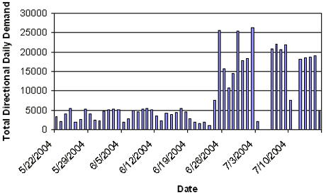
Figure 27. Daily Volume Totals Reported by System Detector #9
The analysis highlighted missing volume data for most days in June along with portions of July 3-6 and July 10-12. The system did not record data for July 4, 5, and 11. The reason that the system log volume data did not match expected, reasonable traffic volumes was unclear. System integrators cited a potential problem in the way the system wrote data to logs early in June, a problem that was not evident in a clear pattern or trend in the data. Sensor operational issues could also be an explanation for the missing data.
Speed and occupancy data were plotted for each detector for several days when lane closures were in place. The system detector data did not show a clear trend in low speeds and high occupancy values for any given day that matched the construction inspector logs. However, the study team observed apparent gaps in data during each day in which construction activities took place.
With the exception of a small number of data points, the occupancy values recorded by the system appeared reasonable. Less than 1 percent of all occupancy values observed were higher than 12 percent occupancy—a value where traffic flow borders on unstable operations.[5] However, some data points may not have been archived.
The system recorded average speeds for each time period listed, while a large amount of observations showed a speed reading of "240" (a default value recorded when an accurate average speed measurement could not be determined). Table 20 shows the percentage of undetermined average speed observations by sensor and the total number of observations where the system made no determination of speed. For some sensors, the system recorded a large portion of the total speed measurements as "240." Additionally, sensors 5 and 7 had much lower total observations than the remaining sensors. Clearly, some issues existed with the data set.
| System Detector | Lane 1 (240) |
Lane 2 (240) |
Total (Values) | Percentage Lane 1 (240 to Total) | Percentage Lane 2 (240 to Total) |
|---|---|---|---|---|---|
| 1 | 3057 | 10804 | 24566 | 12% | 44% |
| 2 | 19748 | 4975 | 23551 | 84% | 21% |
| 3 | 8182 | 7330 | 25287 | 32% | 29% |
| 4 | 7740 | 10617 | 25433 | 30% | 42% |
| 5 | 4895 | 6390 | 15651 | 31% | 41% |
| 6 | 15132 | 2551 | 22200 | 68% | 11% |
| 7 | 2726 | 1449 | 6255 | 44% | 23% |
| 8 | 7813 | 2417 | 23073 | 34% | 10% |
| 9 | 3256 | 1800 | 23671 | 14% | 8% |
| 10 | 4442 | 1934 | 25336 | 18% | 8% |
Dynamic Message Sign Data
The system archived message logs for the same time period as traffic data. The archives included more than 100,000 records. The study team observed missing data for the same time periods in the message logs as were observed in the traffic data logs. However, the study team made some important observations from the message logs.
Throughout the deployment, the system posted nearly 30 different messages at different times. The system often posted delay messages, but the study team did not observe messages showing delays other than 15 or 30 minutes. On multiple occasions, the system posted delay messages for very short periods followed by a general message showing no delay through the work zone. In addition, message boards in sequence along the same approach to the work zone were inconsistent.
The system used several preprogrammed messages, and operators had the ability to override the system and post messages manually as needed. In addition to the pre-determined messages listed below, some message signs were blank during several time periods, often after the testing period was complete. A few messages included a mix of words and random letters and symbols.
Messages Showing Delay
- 15 MINUTE DELAY / EXIT 180 TO EXIT 184.
- 15 MINUTE DELAY / SLOW MOVING TRAFFIC.
- I-40 15 MIN DELAY / NEAR CLEMMONS EXIT 184.
- I-40 15 MIN. DELAY / NEAR CLEMMONS EXIT 184.
Messages Showing No Delay
- I-40 WORKZONE INFO / NO DELAY EXIT 180 TO 184.
- I-40 WORKZONE INFO / NO DELAY EXIT 184 TO 180.
- REALTIMETRAFFIC INFO / NO DELAY NEXT 4 MILES.
- SPEED LIMIT 65 / DRIVE SAFELY.
Example Test Message
- MESSAGE SIGN TEST / DRIVE WITH CAUTION.
Messages Encouraging or Requiring Diversion
- 30 MIN DELAY AHEAD / USE EXIT 170 AS ALT.
- I-40 CLOSED AHEAD / TAKE 421 TO I-77.
- I-40 CLSD AT EXIT 182.
- I-40 CLSD AT EXIT 182 / EXPECT DELAYS.
- I-40 CLSD AT EXIT 182 / TAKE 421 TO I-77.
Messages Showing General Traffic Conditions
- CAUTION CAUTION CAUTION / LEFT LANE CLOSED / 2 MILES AHEAD.
- I-40 WORKZONE ALERT / TRAFFIC SLOWING AHEAD.
- REALTIMETRAFFIC INFO / TRAFFIC SLOWING AHEAD.
- REDUCED SPEED AHEAD / USE CAUTION.
- ROAD WORK AHEAD / DRIVE SAFELY.
- ROAD WORK ON I-40 / EXPECT DELAYS ON I-40.
- SLOW MOVING TRAFFIC / DRIVE FRIENDLY / EXPECT DELAYS.
- SLOW TRAFFIC AHEAD.
Other Messages
- BUCKLE UP / DRIVE SAFELY.
- CAUTION CAUTION CAUTION / ONE LANE ROAD AHEAD / PREPARE TO STOP.
- FLAGMAN AHEAD / SHELBY FARMS MUSIC / PREPARE TO STOP AHEAD.
On several occasions (especially for weekend activities), NCDOT moved message boards to different locations. NCDOT remobilized the system during one complete road closure on westbound I-40 from Friday June 4, 2004, at 8:53 p.m. until Saturday June 5, 2004, at approximately 5:17 p.m. NCDOT moved six of the message boards to different locations and posted the following messages:
- I-40 CLOSED AHEAD / TAKE 421 TO I-77.
- I-40 CLSD AHEAD / TAKE 421 TO I-77.
The study team was aware of the planned closure, but decided not to collect supplemental data that weekend due to the short duration and limited options for through travelers. Prior to the closure, NCDOT provided information to the media on the planned activities and alternate routes. A local newspaper article[6] cited delays on I-40 and US-158, the alternate route for local traffic and motorists who misunderstood the I-40 message signs. The article referenced a message sign that mentioned exit 182 as the last exit prior to the closure. A local reporter interviewed motorists who said they were confused and thought they would reach 421 at that exit.
The system also posted the message "30 MIN DELAY AHEAD / USE EXIT 170 AS ALT" during the complete closure on June 5, 2004, for 3 minutes at approximately 11:00 a.m. and 7 minutes at approximately 12:00 p.m. The system used two versions of the message, with the difference being the presence of a period after "MIN" in the alternate version of the message listed above. The system posted these messages randomly, once on DMS005 and once on DMS003, during the complete directional closure.
Exit 170 is the I-40 off ramp to US-601, which was one of the signed alternate routes. NCDOT did not have information on the exact system layout during the weekend closure, although they may have moved the boards to locations where they targeted eastbound motorists prior to exit 170 and the work zone. The two occasions on June 5, 2004, were the only observations from the data where the system posted 30 minute delays along with alternate route information—the fullest extent to which the system could activate.
Despite some data inconsistencies, the study team found very useful information from this evaluation. Although the deployment did not allow for the quantitative assessment of system benefits desired, the study team uncovered several lessons learned to the benefit of NCDOT and others interested in deploying similar systems.
Tips and Lessons Learned
Deployment Tips and Lessons Learned
The ITS schedule needs to be linked to the construction schedule to maximize use and benefit of the system. At this site, the system was deployed after several weeks where significant traffic impacts had occurred. To achieve the maximum benefit, ITS should be operational prior to any lane restrictions.
Delays occurred not only at lane drops, but also within the work zone due to slow moving trucks that deliver materials to the site. NCDOT learned this lesson from past deployments, so for this deployment, NCDOT placed extra sensors within the work area.
In design and implementation of ITS for work zone applications, agencies should involve the construction contractor to the fullest extent possible. Local NCDOT representatives cited the need to involve the construction contractor to the extent that they are fully aware of goals and objectives for the system, even if the contractor is not involved in the procurement of the system.
ITS deployments for work zone applications require communications and technology experts along with traffic engineering experts. A hardware / software / communications expert should be in regular (e.g., daily) contact with a traffic engineer to ensure full system functionality and that the ultimate goals of the system are achieved. For this deployment, NCDOT engineers coordinated with vendor communications experts to deploy the system.
The vendor and the implementing agency should discuss in sufficient detail the concept of operations for the system, reach an understanding of exactly how it will process information, and determine what messages to post. Technology can easily become a "black box" where data are input and actions result. A champion for the deployment should be familiar with all aspects of system functionality and should guide the vendor.
Implementing agencies should use verification techniques to validate the outputs of the system and refine system operating procedures as needed prior to implementation. Agencies should perform a dry run using a test data set to simulate traffic condition information to monitor the system and verify output. Agencies should also develop performance metrics prior to system implementation to establish specific means of monitoring how well the system worked during the deployment. For this deployment, observation and analysis of interim data proved difficult due to the level of effort needed to access and view preliminary data sets. Therefore, NCDOT relied on the vendor to ensure system functionality and accuracy.
The system should use message board controls to prevent conflicting messages from being displayed along the same approach to the work zone area. At this study site, message logs showed that motorists observed conflicting messages, including delay warnings followed by free flow condition messages.
Personnel from the implementing agency should have real-time access to archived system data to identify any issues and monitor system functionality. A Web site could easily provide password protected access to the data being used by the system to make decisions. The Web site for this project provided access to real-time data but did not provide access to the data archives.
Deploying agency representatives should engage personnel responsible for use of supplemental components (such as NCDOT's permanent DMS for use during high delay periods) on a regular basis to ensure that everyone is current on the concept of operations and their roles and responsibilities. The North Carolina deployment relied on a portable work zone system as well as using some components of a permanent traffic management system.
Evaluation and Research Tips and Lessons Learned
A successful evaluation of a work zone ITS deployment relies heavily on the cooperation of each entity involved, including the implementing agency, the vendor, and especially the personnel responsible for successful completion of the construction project. For this evaluation, all parties were helpful in obtaining necessary information. Priorities must be set as the needs of the evaluation can often place a burden on personnel involved with system deployment and operation.
In developing an evaluation plan, evaluators should focus on a prioritized set of metrics that will provide the greatest opportunities to test the benefits of the system. In depending on the use of a specific data source, evaluators should test a sample data set to identify any irregularities and to confirm the format needed for analysis.
Research into the use of non-intrusive detector data to quantify traffic flow conditions in work zones is warranted. This evaluation highlights a greater understanding of detector outputs, but additional work is needed to compare actual traffic conditions with data observed through microwave sensors.
- May, Adolf D., "Traffic Flow Fundamentals," Prentice-Hall, New Jersey, 1990, page 194.
- Patrick Wilson, "Traffic meets drivers detoured from Interstate 40," The Winston-Salem Journal, June 6, 2004, http://www.journalnow.com.