
Description of 511 Deployment Status
Description
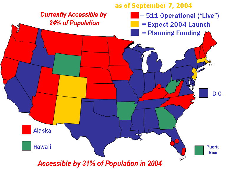
U.S. map showing states and their 511 deployment status as of September 7, 2004.
511 is currently accessible by 24% of population.
511 will be accessible by 31% of population in 2004
States that are 511 operational (live):
- Northern Kentucky/Cincinnati, Ohio
- Nebraska
- Utah
- I-81 section of Virginia
- Arizona
- Minnesota
- South Florida (Miami)
- Orlando, I-4 section
- Tampa, Florida
- South Dakota
- Iowa
- Kentucky
- San Francisco Bay area, California
- Sacramento, California
- Montana
- North Dakota
- Alaska
- Maine
- New Hampshire
- Washington State
- Vermont
- Oregon
- Kansas
- North Carolina
States that expect 2004 launch:
- Colorado
- New Mexico
- Massachusetts
- New Jersey
States with planning funding:
- Southern California
- Nevada
- Idaho
- Texas
- Oklahoma
- Louisiana
- Mississippi
- Alabama
- Tennessee
- Missouri
- Illinois
- Wisconsin
- Michigan
- Indiana
- Ohio
- Pennsylvania
- New York
- Connecticut
- Rhode Island
- Maryland
- Delaware
- District of Columbia
- Eastern section of Virginia
- South Carolina
- Florida
States that do not show 511 accessibility:
- Wyoming
- West Virginia
- Hawaii
- Georgia
- Arkansas
- Puerto Rico