
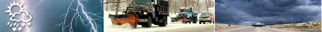
Surveillance, Monitoring and Prediction
Surveillance, Monitoring and Prediction
About Surveillance, Monitoring and Prediction
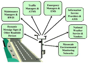
To make road weather management decisions, transportation managers must access data on environmental conditions from observing systems and forecast providers. Observing system technologies include fixed environmental sensor stations (ESS), mobile sensing devices, and remote sensing systems. Environmental observations ultimately support predictive information for decision support applications. Predictions of environmental conditions can be obtained from public sources, such as the National Weather Service and the National Hurricane Center, and from private meteorological service providers. Environmental data may also be obtained from mesoscale environmental monitoring networks, or mesonets, which integrate and disseminate data from many observing systems (including agricultural, flood monitoring and aviation networks). The NOAA Meteorological Assimilation Data Ingest System (MADIS) is a data management system that collects data from surface surveillance systems, hydrological monitoring networks, balloon-borne instruments, Doppler radars, aircraft sensors, and other sources. The NOAA Surface Weather Program will transition MADIS into operations as they develop the National Surface Weather Observing System (NSWOS). The NSWOS will ultimately include ESS data collected through the Clarus System. The NSWOS will integrate disparate observations systems and formats to meet the needs of various user communities, including transportation agencies.
Environmental Sensor Stations (ESS) and Road Weather Information Systems (RWIS)
An Environmental Sensor Station (ESS) is a roadway location with one or more fixed sensors measuring atmospheric, pavement and/or water level conditions. Atmospheric data include air temperature and humidity, visibility distance, wind speed and direction, precipitation type and rate, tornado or waterspout occurrence, lightning, storm cell location and track, as well as air quality. Pavement data include pavement temperature, pavement freeze point, pavement condition (e.g., wet, icy, flooded), pavement chemical concentration, and subsurface conditions (e.g., soil temperature). Water level data include tide levels (e.g., hurricane storm surge) as well as stream, river, and lake levels near roads. The Interactive ESS Page provides more information on the various sensors that may be included in an ESS.
 ESS Operational Applications
As shown on the National ESS Map, there are over 2,400 ESS owned by state transportation agencies. Most of these stations - over 2,000 - are field components of Road Weather Information Systems (RWIS), which are typically used to support winter road maintenance activities. The other stations are deployed for various applications including traffic management, flood monitoring, and aviation. Central RWIS hardware and software collect field data from numerous ESS, process data to support various operational applications, and display or disseminate road weather data in a format that can be easily interpreted by a manager. To share information on Environmental Sensor Stations in your state, contact Weather Feedback at WeatherFeedback@dot.gov.
Mobile Sensing
Mobile sensors are deployed to observe environmental conditions from any type of vehicle. Vehicle-mounted sensor systems can be utilized to sense pavement conditions (e.g., temperature, friction) and atmospheric conditions (e.g., air temperature), which are transmitted to central locations via Automated Vehicle Location (AVL) and Global Positioning System (GPS) technologies. An important mobile sensing application is thermal mapping of road segments. This technique provides pavement temperature profiles that can be used both to select ESS sites and to spatially predict temperatures based upon ESS data. Transportation agencies in Iowa, Michigan, and Minnesota have partnered to deploy and evaluate advanced maintenance vehicles equipped with mobile environmental sensors, including a pavement freeze point sensor and a friction measuring device.
The USDOT ITS Research program on connected vehicles aims to deploy advanced vehicle-vehicle and vehicle-infrastructure communications. This will involve the collection of various data types from passenger vehicles, including weather and pavement condition data, for multiple applications. As input to the VII Initiative, the Road Weather Management Program has worked to promote three weather-related applications: Winter Maintenance, Weather Information for Traveler Notification, and Weather Information for Improved Forecasting. The Winter Maintenance application will integrate traditional sources of road weather data with sensor data from VII-equipped vehicles (both private vehicles and maintenance vehicles) to support road treatment decisions, and to communicate treatment information to maintenance vehicles in an expeditious manner. The Weather Information for Traveler Notification application will gather probe data generated by VII vehicles, analyze and integrate those observations with weather data from traditional sources, develop route-specific weather reports and forecasts, and disseminate information over the VII network to areas impacted by weather events. The Weather Information for Improved Forecasting application will focus on the use of probe data to improve the weather forecasting process. It will not provide weather-related information back to the vehicle.
The program has also sponsored preliminary mobile sensing research. Mitretek Systems performed foundational research on the characteristics and the feasibility of using vehicles as meteorological sensor platforms. Vehicles were equipped with air temperature sensors in the front bumper, near the engine air intake cowling, and in the rear bumper. More information on this research can be found in a presentation on Vehicles as Mobile Meteorological Platforms: Introductory VII Research (PPT 6.5MB). The National Center for Atmospheric Research (NCAR) conducted a feasibility study to explore and assess the utility of using data from vehicles to improve surface transportation weather observations and predictions and road condition hazard analyses and predictions. Researchers identified technical issues and challenges related to the use of vehicle data, and provided recommendations that will help ensure successful exploitation of vehicle probe data in weather applications.
Remote Sensing
In remote sensing, a detector is located at a significant distance from a target. The sensor can be mounted on unmanned aerial vehicles or part of a radar or satellite system used for surveillance of meteorological and oceanographic conditions. Images and observations from remote sensors are used for weather monitoring and forecasting from local to global scales. Remote sensing is used for quantitatively measuring atmospheric temperature and wind patterns, monitoring advancing fronts and storms (e.g., hurricanes, blizzards), imaging of water (i.e., oceans, lakes, rivers, soil moisture, vapor in the air, clouds, snow cover), as well as estimating runoff and flood potential from thawing.
As part of the Clarus Initiative, the FHWA has sponsored foundational research to assess the feasibility of obtaining video imagery from State DOT Closed Circuit Television (CCTV) cameras to determine if new surface transportation-related elements can be derived. Researchers at the MIT Lincoln Laboratory have created an algorithm that uses visible camera imagery, with automated orientation, to estimate roadway visibility. More information on this research can be found in the Automated Extraction of Weather Variables from Camera Imagery report.
