Integrated Modeling for Road Condition Prediction — Phase 3 Evaluation Report
Chapter 1. Introduction
In 2015, the Federal Highway Administration (FHWA) began efforts to describe and create a tool that fuses real-time and/or archived data with results from an ensemble of forecast and probabilistic models to predict current and future overall road and travel conditions for travelers, transportation operators, and maintenance providers.
The Integrated Modeling for Road Condition Prediction (IMRCP) system is a prototype system and demonstration deployment that provides a framework for integrating road condition monitoring and forecast data to support decisions by travelers, transportation operators, and maintenance providers. The system collects and integrates environmental and transportation operations data, collects forecast weather data, initiates road weather and traffic forecasts, generates advisories and warnings, and provides the results to other applications and systems. The model could ultimately become a practical tool for transportation agencies to support traveler advisories, maintenance plans, and operational decisions at strategic and tactical levels.
Project Description
The foundational tasks for characterizing IMRCP in Phase 1 included development of a concept of operations and requirements. In the IMRCP Phase 2, the research team specified, implemented, tested, and evaluated the IMRCP concept in a demonstration deployment in part of the Kansas City metropolitan area. In IMRCP Phase 3, the objectives were to build upon the Phase 2 demonstration deployment in the Kansas City area. This involved increasing coverage to the entire Kansas City metropolitan area highways, adding an additional (alternative) traffic model, operating the system through two winter seasons, evaluating the operational results, and updating project documents.
Research, development, and operations stakeholders have been involved throughout the IMRCP effort. Operations stakeholders helped identify the system functions and interfaces and provided feedback on the usefulness of the model results. This project included:
- A survey of available and imminent weather, hydrological, traffic, and related transportation management models;
- Development of a concept of operations and fundamental system requirements;
- Development of a system architecture and system design;
- Implementation of a foundational system;
- Deployment of the system with an operating transportation agency to evaluate its effectiveness.
The IMRCP system provides an integrated view of forecast road weather and traffic conditions for a given road network. The IMRCP model draws input from traffic, weather, and hydrological data sources to estimate current conditions and forecast future conditions. Forecasts are available via web interface on maps, in reports, and in subscriptions. Traffic data sources, such as advanced transportation management systems, provide volumes, speeds, freeway control and traffic signal operations data, incident reports, and plans for work zones and special events. Current and forecast atmospheric and hydrological conditions are drawn from National Weather Service sources. State and local agencies provide specialized road weather conditions, such as pavement temperatures. Data collected from the various sources are indexed, stored, and archived in a heterogeneous data store by the system.
While atmospheric and hydrological forecasts, work zones, and special events data are taken from external sources, the IMRCP system synthesizes road weather and traffic condition predictions with embedded best-in-class forecast models. The current IMRCP system implementation estimates road weather conditions across the network using field measurements of conditions and predicts conditions based on atmospheric forecasts using the Model of the Environment and Temperature of Roads (METRo). The system estimates current traffic conditions from detector stations and demand models and predicts conditions from road weather, incident, and demand forecasts using the Traffic Estimation and Prediction System (TrEPS)/Dynamic Traffic Assignment model and a machine learning-based traffic prediction model (MLP).
Phase 3 of the IMRCP project built upon the Phase 2 demonstration deployment in the Kansas City area. This involved increasing coverage to the entire Kansas City metropolitan area highways and adding the additional traffic model (the machine learning-based traffic prediction model). The IMRCP Phase 3 study area greatly extended the Phase 2 area to include all freeways monitored by the Kansas City Scout (KC Scout) traffic management center (TMC), as shown in figure 1.
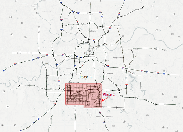
Source: Federal Highway Administration; OpenStreetMap®contributors.
Figure 1. Map. Integrated Model for Road Condition Prediction Phase 2 and Phase 3 deployment area in Kansas City area.
This map shows the major Interstates and State highways around Kansas City. Phase two is highlighted in red and is a rectangular area in the lower center portion of the map, and covers approximately five percent of the total map area. Phase three includes the entire map area. The highways included in the study are drawn in black and labeled with either the colored red, white and blue Interstate highway label or a black and white State highway label.
Purpose and Overview
The purpose of the evaluation is to explore whether IMRCP had an impact on KC Scout operations and to assess whether the information was useful to KC Scout operators and supervisors. The findings from this evaluation could inform others who may be considering similar deployments and provide FHWA with information to help determine next steps for IMRCP.
This evaluation report consists of five chapters:
- Chapter 1. Introduction (this chapter) provides a description of the project, the evaluation purpose, and an overview of the document.
- Chapter 2. Evaluation Approach describes the evaluation approach and objectives.
- Chapter 3. Results describes the analyses of the IMRCP data and operator interviews.
- Chapter 4. Findings discusses the implications of the analyses related to the IMRCP evaluation operational improvements and user satisfaction objectives.
- Chapter 5. Conclusion reiterates key results that support the findings.
previous | next