6.4 Track 3: Expand ITS
The projects identified in this section are intended to expand the coverage
of existing systems, and to add new ITS functions and services regionally.
They include ITS on freeways, several transit projects, emergency vehicle
pre-emption at traffic signals within the City of Cincinnati, snow and ice
detection and advanced snow plows for improved snow and ice operations, parking
management, and safety projects. The projects that have a defined geographic
scope are illustrated on Figures 6-2A and 6-2B. To expand ITS, the following
fifteen projects were identified:
15. ARTIMIS Field Device and Communications Expansion
(shown on Figures 6-2A and 6-2B)
16. Complete 1/10th Freeway Reference Markers Coverage
(shown on Figures 6-2A and 6-2B)
17. Highway-Rail Intersection Advanced Safety System
18. METRO/TANK Transit Itinerary Planning System
19. METRO Advanced Para-Transit Scheduling and Dispatch System
20. TANK Advanced Para-Transit Scheduling and Dispatch System
21. Ramp Metering on I-75 within the City of Cincinnati
22. Bus Traffic Signal Priority
23. Real-Time Transit Arrival Information System
24. Truck-Oriented Traveler Information System
25. Emergency Vehicle Pre-Emption on City of Cincinnati Traffic Signals
(shown on Figures 6-2A and 6-2B)
26. Bridge Snow and Ice Detection
27. Research Program/Downhill Speed Detection Field Test on I-71/I-75
(shown on Figures 6-2A and 6-2B)
28. Advanced Snow Plows
29. Parking Management System Around Stadiums
30. Red Light Enforcement
The tables following Figures 6-2A and 6-2B provide additional detail on the
projects in Track 3.
Figure 6-2A. Track 3: Expand ITS
(Ohio)
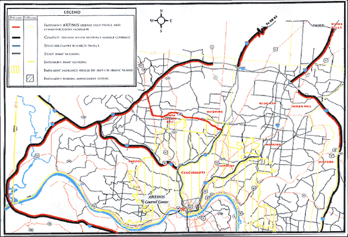
Figure 6-2B. Track 3: Expand ITS
(Kentucky)

TRACK 3: EXPAND
Project 15: ARTIMIS Field Device Expansion (Part 1 – Kentucky)
| PROJECT |
DESCRIPTION |
CAPITAL COST ESTIMATE |
| 0 – 6 YEARS |
7
– 10 YEARS |
0 – 6 YEARS |
7
– 10 YEARS |
| Kentucky ARTIMIS Freeway Field Device and Communications Expansion |
Extend ARTIMIS field devices and communications on freeway system.
- I-471 River to I-275
- I-275: River to River
- I-71/75: U.S. 42 Interchange south to I-71/75 split
|
Implement |
 |
$18,500,000 |
|
Please see Table 6-3 for a complete list
of ITS needs. This project’s primary function will significantly address
the following ITS needs:
1. Better management of congestion caused by incidents on freeways
and major arterials
2. Alleviate peak hour traffic congestion
3. Reduce the length of time that crashes block roadways
5. Reduce the length of time that crashes block roadways
7. Apply lessons learned from current ITS applications to maximize the benefits
of existing systems
8. Lack of means to create a current picture of the regional transportation
network
TRACK 3: EXPAND
Project 15: ARTIMIS Field Device Expansion (Part 2 – Ohio)
| PROJECT |
DESCRIPTION |
CAPITAL COST ESTIMATE |
| 0 – 6 YEARS |
7
– 10 YEARS |
0 – 6 YEARS |
7
– 10 YEARS |
| Ohio ARTIMIS Freeway Field Device and Communications Expansion |
Extend ARTIMIS field devices and communications on freeway system. Target
the installation to meet needs. Full instrumentation may not be required. |
|
|
$18,500,000 |
|
|
|
Implement |
|
|
|
|
|
Implement |
|
|
|
|
|
|
Implement |
|
|
|
- Ronald Reagan Highway: I-75 to I-275
|
Implement |
|
$40,500,000 |
$10,500,000 |
|
- I-74: I-75 Interchange to I-74/I-275 easternmost interchange
|
Implement |
|
|
|
|
- I-74: I-275 to New Haven Interchange
|
|
Implement |
|
|
|
|
Implement |
|
|
|
|
- I-71: I-275 to Kings Mill Rd. (SR 741)
|
Implement |
|
|
|
|
|
Implement |
|
|
|
|
- Ronald Reagan Highway: I-75 to I-71
|
Implement |
|
|
|
TRACK 3: EXPAND
Project 16: Complete 1/10th Freeway Reference Markers Coverage
| PROJECT |
DESCRIPTION |
CAPITAL COST ESTIMATE |
| 0 – 6 YEARS |
7 – 10 YEARS |
0 – 6 YEARS |
7 – 10 YEARS |
| Kentucky 1/10th mile Reference Markers |
Complete freeway system reference marker coverage. |
Implement |
|
$150,000 |
|
| Ohio 1/10th mile Reference Markers |
Complete freeway system reference marker coverage. |
Implement |
|
$480,000 |
|
Please see Table 6-3 for a complete list of ITS needs. This project’s
primary function will significantly address the following ITS needs:
2. Better management of congestion caused by incidents on freeways and
major arterials
3. Alleviate peak hour traffic congestion
5. Reduce the length of time that crashes block roadways
8. Lack of means to create a current picture of the regional transportation
network
TRACK 3: EXPAND
Project 17: Highway-Rail Intersection Advanced Safety Systems
| PROJECT |
DESCRIPTION |
CAPITAL COST ESTIMATE |
| 0 – 6 YEARS |
7 – 10 YEARS |
0 – 6 YEARS |
7 – 10 YEARS |
| Kentucky Highway-Rail Intersection Advanced Safety Systems |
Install Advanced Highway-Rail Safety Systems at key crossings. A study
must be conducted to identify the crossings and the preferred system. |
Implement one site |
Implement one site |
$500,000* |
$500,000* |
| Ohio Highway-Rail Intersection Advanced Safety Systems |
Install Advanced Highway-Rail Safety Systems at key crossings. A study
must be conducted to identify the crossings and the preferred system. |
Implement one site |
Implement one site |
$500,000* |
$500,000* |
| NOTE: Items marked with an asterisk (*) indicate that the
costs are highly uncertain. Further study is needed to better establish
cost estimates. |
Please see Table 6-3 for a complete list of ITS needs. This project’s
primary function will significantly address the following ITS needs:
2. Better management of congestion caused by incidents on freeways and
major arterials
3. Alleviate peak hour traffic congestion
5. Reduce the length of time that crashes block roadways
8. Lack of means to create a current picture of the regional transportation
network
TRACK 3: EXPAND
Project 18: METRO/TANK Transit Itinerary Planning System
| PROJECT |
DESCRIPTION |
CAPITAL COST ESTIMATE |
| 0 – 6 YEARS |
7 – 10 YEARS |
0 – 6 YEARS |
7 – 10 YEARS |
| Kentucky Develop METRO/TANK Transit Schedule and Itinerary Planning
System |
Install a system that enables phone-based, operator assisted, or on-line
transit itinerary planning in real time, and schedule browsing. Project
Assumes TANK would serve as project manager. |
Implement |
|
$1,500,000* |
$500,000* |
| Ohio Develop METRO/TANK Transit Schedule and Itinerary Planning System |
Install a system that enables phone-based, operator assisted, or on-line
transit itinerary planning in real time, and schedule browsing. Project
Assumes TANK would serve as project manager. |
Implement |
|
$1,000,000* |
$500,000* |
| NOTE: Items marked with an asterisk (*) indicate that the
costs are highly uncertain. Further study is needed to better establish
cost estimates. |
Please see Table 6-3 for a complete list of ITS needs. This project’s
primary function will significantly address the following ITS needs:
2. Better management of congestion caused by incidents on freeways
and major arterials
3. Alleviate peak hour traffic congestion
8. Lack of means to create a current picture of the regional transportation
network
TRACK 3: EXPAND
Project 19: METRO Advanced Para-Transit Scheduling and Dispatch System
| PROJECT |
DESCRIPTION |
CAPITAL COST ESTIMATE |
| 0 – 6 YEARS |
7 – 10 YEARS |
0 – 6 YEARS |
7 – 10 YEARS |
| Ohio METRO Advanced Para-Transit Scheduling And Dispatch System. |
Implement an advanced para-transit scheduling and dispatch system at
METRO, coordinated with TANK. |
Implement |
|
$1,500,000* |
|
| NOTE: Items marked with an asterisk (*) indicate that the
costs are highly uncertain. Further study is needed to better establish
cost estimates. |
Please see Table 6-3 for a complete list of ITS needs. This project’s
primary function will significantly address the following ITS needs:
3. Alleviate peak hour traffic congestion
8. Lack of means to create a current picture of the regional transportation
network
TRACK 3: EXPAND
Project 20: TANK Advanced Para-Transit Scheduling and Dispatch System
| PROJECT |
DESCRIPTION |
CAPITAL COST ESTIMATE |
| 0 – 6 YEARS |
7 – 10 YEARS |
0 – 6 YEARS |
7 – 10 YEARS |
| Kentucky TANK Advanced Para-Transit Scheduling And Dispatch System. |
Implement an advanced para-transit scheduling and dispatch system at
TANK, coordinated with METRO. |
|
Implement |
|
$750,000* |
| NOTE: Items marked with an asterisk (*) indicate that the
costs are highly uncertain. Further study is needed to better establish
cost estimates. |
Please see Table 6-3 for a complete list of ITS needs. This project’s
primary function will significantly address the following ITS needs:
3. Alleviate peak hour traffic congestion
8. Lack of means to create a current picture of the regional transportation
network
12. ARTIMIS information needs to be continuously improved to ensure it is
attractive to a large population
TRACK 3: EXPAND
Project 21: I-75 Ramp Metering within City of Cincinnati
| PROJECT |
DESCRIPTION |
CAPITAL COST ESTIMATE |
| 0 – 6 YEARS |
7 – 10 YEARS |
0 – 6 YEARS |
7 – 10 YEARS |
| Ohio I-75 Ramp Metering |
Study ramp metering on I-75 within the City of Cincinnati. Implement ramp metering per the study, in accordance with ODOT and USDOT standards and policy. |
Study |
Implement |
$800,000 |
$4,000,000*
(including some paving costs for queue ramps) |
| NOTE: Items marked with an asterisk (*) indicate that the
costs are highly uncertain. Further study is needed to better establish
cost estimates. |
Please see Table 6-3 for a complete list of ITS needs. This project’s
primary function will significantly address the following ITS needs:
1. Improve congestion around special event venues before and after
events
3. Alleviate peak hour traffic congestion
8. Lack of means to create a current picture of the regional transportation
network
12. ARTIMIS information needs to be continuously improved to ensure it is
attractive to a large population
TRACK 3: EXPAND
Project 22: Bus Traffic Signal Priority
| PROJECT |
DESCRIPTION |
CAPITAL COST ESTIMATE |
| 0 – 6 YEARS |
7 – 10 YEARS |
0 – 6 YEARS |
7 – 10 YEARS |
| Kentucky Bus Traffic Signal Priority |
Study key transit corridors for applicability of bus traffic signal
priority to improve transit travel time. Implement transit signal priority
on traffic signals on identified corridors. |
Study |
Implement 25 intersections |
$75,000 |
$250,000 |
| Ohio Bus Traffic Signal Priority |
Study key transit corridors for applicability of bus traffic signal
priority to improve transit travel time. Implement transit signal priority
on traffic signals on identified corridors. |
Study |
Implement 25 intersections |
$75,000 |
$250,000 |
Please see Table 6-3 for a complete list of ITS needs. This project’s
primary function will significantly address the following ITS needs:
1. Better management of congestion caused by incidents on freeways
and major arterials
3. Alleviate peak hour traffic congestion
8. Lack of means to create a current picture of the regional transportation
network
TRACK 3: EXPAND
Project 23: Real-Time Transit Arrival Information System
| PROJECT |
DESCRIPTION |
CAPITAL COST ESTIMATE |
| 0 – 6 YEARS |
7 – 10 YEARS |
0 – 6 YEARS |
7 – 10 YEARS |
| Ohio METRO Real-Time Transit Arrival Information |
Expand METRO AVL capabilities to enable public access to real-time transit
arrival information. Deploy signs at key bus stops/transfer points. Enable
Internet access to bus arrival times by route. |
Implement |
|
$2,500,000* |
|
| NOTE: Items marked with an asterisk (*) indicate that the
costs are highly uncertain. Further study is needed to better establish
cost estimates. |
Please see Table 6-3 for a complete list of ITS needs. This project’s
primary function will significantly address the following ITS needs:
3. Alleviate peak hour traffic congestion
8. Lack of means to create a current picture of the regional transportation
network
TRACK 3: EXPAND
Project 24: Truck-Oriented Traveler Information Systems
| PROJECT |
DESCRIPTION |
CAPITAL COST ESTIMATE |
| 0 – 6 YEARS |
7 – 10 YEARS |
0 – 6 YEARS |
7 – 10 YEARS |
| Kentucky Truck-Oriented Traveler Information |
Implement specialized trucker-oriented traveler information via ARTIMIS
and at weigh stations approaching the region. Information on weight restrictions,
transit routes, truck stops, construction and incidents specific to the
trucking community would be implemented via telephone numbers, DMS and/or
kiosks. |
Implement |
|
$750,000* |
|
| Ohio Truck-Oriented Traveler Information |
Implement specialized trucker-oriented traveler information via ARTIMIS
and at weigh stations approaching the region. Information on weight restrictions,
transit routes, truck stops, construction and incidents specific to the
trucking community would be implemented via telephone numbers, DMS and/or
kiosks. |
Implement |
|
$750,000* |
|
| NOTE: Items marked with an asterisk (*) indicate that the
costs are highly uncertain. Further study is needed to better establish
cost estimates. |
Please see Table 6-3 for a complete list of ITS needs. This project’s
primary function will significantly address the following ITS needs:
2. Better management of congestion caused by incidents on freeways
and major arterials
3. Alleviate peak hour traffic congestion
5. Reduce the length of time that crashes block roadways
8. Lack of means to create a current picture of the regional transportation
network
TRACK 3: EXPAND
Project 25: Emergency Vehicle Pre-Emption on City of Cincinnati Traffic Signals
| PROJECT |
DESCRIPTION |
CAPITAL COST ESTIMATE |
| 0 – 6 YEARS |
7 – 10 YEARS |
0 – 6 YEARS |
7 – 10 YEARS |
| Ohio City of Cincinnati EVPE |
Install Emergency Vehicle Pre-emption on traffic signals in the City
of Cincinnati. Does not include equipment for emergency vehicles. |
Implement at up to 100 intersections |
|
$1,100,000 |
|
Please see Table 6-3 for a complete list of ITS needs. This project’s
primary function will significantly address the following ITS needs:
2. Better management of congestion caused by incidents on freeways
and major arterials
3. Alleviate peak hour traffic congestion
4. Curtail behaviors that contribute to crashes
5. Reduce the length of time that crashes block roadways
6. Reduce delays to emergency vehicles on arterials
8. Lack of means to create a current picture of the regional transportation
network
TRACK 3: EXPAND
Project 26: Bridge Snow and Ice Detection
| PROJECT |
DESCRIPTION |
CAPITAL COST ESTIMATE |
| 0 – 6 YEARS |
7 – 10 YEARS |
0 – 6 YEARS |
7 – 10 YEARS |
| Kentucky Freeway Bridge Snow and Ice Detection |
Install snow and ice detection (Road Weather Information System) on
key interstate bridges |
Implement at up to ten sites |
|
$300,000 |
|
| Ohio Freeway Bridge Snow and Ice Detection |
Install snow and ice detection (Road Weather Information System) on
key interstate bridges |
Implement at up to five sites |
|
$150,000 |
|
Please see Table 6-3 for a complete list of ITS needs. This project’s
primary function will significantly address the following ITS needs:
3. Alleviate peak hour traffic congestion
8. Lack of means to create a current picture of the regional transportation
network
TRACK 3: EXPAND
Project 27: Research Program and Downhill Speed Detection Field Test on I-71/I-75
| PROJECT |
DESCRIPTION |
CAPITAL COST ESTIMATE |
| 0 – 6 YEARS |
7 – 10 YEARS |
0 – 6 YEARS |
7 – 10 YEARS |
| Kentucky Research Program |
Establish a research program, in conjunction with universities, to
test new implementation concepts. Suggested first project is northbound
I-71/ I-75 downhill crash mitigation system in Kentucky (in Covington). |
Implement |
Implement |
$450,000
($150,000 per year) |
$300,000
($150,000 per year) |
| Ohio Freeway Bridge Snow and Ice Detection |
Establish a research program, in conjunction with universities, to test
new implementation concepts. Suggested first project is northbound I-71/
I-75 downhill crash mitigation system in Kentucky (in Covington). |
Implement |
Implement |
$450,000
($150,000 per year) |
$300,000
($150,000 per year) |
Please see Table 6-3 for a complete list of ITS needs. This project’s
primary function will significantly address the following ITS needs:
3. Alleviate peak hour traffic congestion
4. Curtail behaviors that contribute to crashes
8. Lack of means to create a current picture of the regional transportation
network
TRACK 3: EXPAND
Project 28: Advanced Snow Plows
| PROJECT |
DESCRIPTION |
CAPITAL COST ESTIMATE |
| 0 – 6 YEARS |
7 – 10 YEARS |
0 – 6 YEARS |
7 – 10 YEARS |
Kentucky
Install snow and ice detection, management and advanced snow plow systems. |
Pilot project to assess use of road weather information
systems integrated with advanced technology snow plows. These systems
provide early warning of icing and snow, and meter the amount of chemical
and/or sand applied based on surface conditions, including amount of chemical
already applied. Savings in chemical and sand, and reduction of ice and
snow-related incidents are anticipated. A lead agency must be selected
for this project, or the project can be implemented through the Research
program, if implemented. |
Study |
|
$150,000 |
|
|
Implement |
|
$5,000,000* |
| NOTE: Items marked with an asterisk (*) indicate that the
costs are highly uncertain. Further study is needed to better establish
cost estimates. |
Please see Table 6-3 for a complete list of ITS needs. This project’s
primary function will significantly address the following ITS needs:
3. Alleviate peak hour traffic congestion
8. Lack of means to create a current picture of the regional transportation
network
TRACK 3: EXPAND
Project 29: Parking Management System Around Stadiums
| PROJECT |
DESCRIPTION |
CAPITAL COST ESTIMATE |
| 0 – 6 YEARS |
7 – 10 YEARS |
0 – 6 YEARS |
7 – 10 YEARS |
| Ohio Parking Management System Around Stadiums |
Install parking management system connecting lots and garages
near stadiums with on-street DMS and/or HAR and ARTIMIS. Three levels
of parking management could be evaluated. All three require information
dissemination via DMS and/or HAR and ARTIMIS. The first level involves
human visual assessments of parking availability, and e-mail or phoning
those assessments to a central location where parking information would
be disseminated. The second level involves installing automated counters
at parking entrances, which relay information to the centralized system
automatically for dissemination. The third level involves installing detection
in every affected parking space, with the capability of guiding drivers
to an exact parking space in addition to sending information to a centralized
system for dissemination. A public-private partnership should be explored
for deployment. |
Implement at up to 100 intersections |
|
$1,100,000 |
|
|
|
|
|
| NOTE: Items marked with an asterisk (*) indicate that the
costs are highly uncertain. Further study is needed to better establish
cost estimates. |
Please see Table 6-3 for a complete list of ITS needs. This project’s
primary function will significantly address the following ITS needs:
1. Improve congestion around special event venues before and after
events
3. Alleviate peak hour traffic congestion
8. Lack of means to create a current picture of the regional transportation
network
TRACK 3: EXPAND
Project 30: Red Light Running Enforcement
| PROJECT |
DESCRIPTION |
CAPITAL COST ESTIMATE |
| 0 – 6 YEARS |
7 – 10 YEARS |
0 – 6 YEARS |
7 – 10 YEARS |
| Red-Light Running System |
State of Ohio Pilot Project to test effectiveness, fairness and legal issues related to automated red-light enforcement using cameras. |
Study |
|
$0 (Funded separately via State of Ohio) |
|
Please see Table 6-3 for a complete list of ITS needs. This project’s primary function will significantly address the following ITS needs:
3. Alleviate peak hour traffic congestion
4. Curtail behaviors that contribute to crashes
8. Lack of means to create a current picture of the regional transportation
network
previous page
