Traffic Analysis Tools Volume IX: Work Zone Modeling and Simulation
A Guide for Analysts
Wisconsin DOT: Transportation Management Plan Development Process
Wisconsin Department of Transportation Work Zone Transportation Management Plans[12]
Overview
The Wisconsin DOT (WisDOT) has established guidelines on the development of Transportation Management Plans (TMP) as part of overall project delivery process during the design and construction stages. The formal process for developing a TMP is shown in Figure 1 below. While the extent of the TMP depends upon the nature of the project (location, size, duration, etc.), WisDOT recommends that a systematic assessment of work zone impacts be conducted for construction projects that impact travel lanes. (Minor maintenance projects that do not affect roadway capacity, classified as Type 1 TMPs in Wisconsin, generally do not require an analysis). Development of the TMP is designed to mitigate, to the greatest extent possible, safety and mobility impacts to workers and the public.
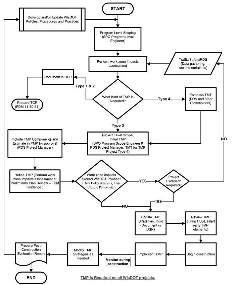
Figure 32 WisDOT Transportation Management Plan Development Process
In order to conduct the work zone impact assessment, WisDOT has formalized guidance used by regional offices in determining the extent to which work zone impacts need to be analyzed. This document is called the Lane Closure and Delay Guideline. With the guideline, WisDOT provides recommendations on the selection and use of traffic modeling tools for assessing the impact of various types of work zones.
A web-based database called the Lane Closure System (LCS) has been developed to handle the administrative process of approving lane closures. It is also used to keep track of lane closure status and will feed closure data to Wisconsin’s 511 traveler information system.
Lane Closure and Delay Guidelines
In 2007 WisDOT updated their Facilities Development Manual to include guidelines for planning typical lane closures and methodologies for considering regularly occurring high volume periods with special considerations for holidays and planned special events. The lane closure guidelines establish a formal process which planners, engineers and operations managers follow in order to evaluate proposed lane closures. The process includes the following six steps (visually represented in Figure 33):
- Determine route-specific maximum delay guideline and recommended lane closure times.
- Estimate capacity under proposed lane closure.
- Estimate hourly demand profile.
- Estimate queues and delays using appropriate tools.
- Identify appropriate mitigation strategies.
- Plan and prepare for special conditions.
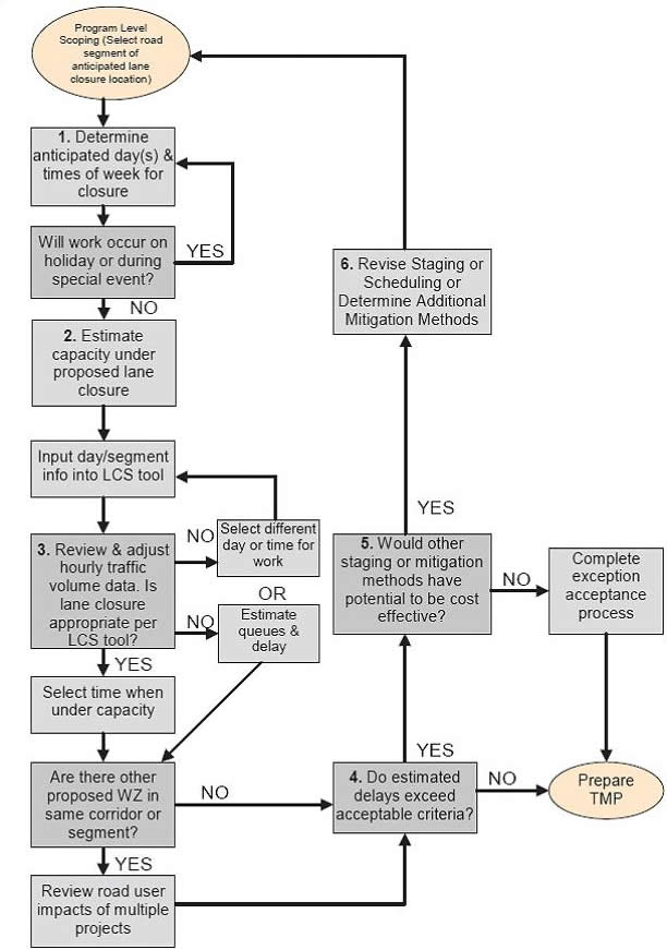
Figure 33 Lane Closure Analysis Process
The guidelines include suggested procedures and methodologies to estimate the capacity of a roadway segment, determine traffic demand, and quantify resulting queues and delays using traffic volume data. Important to the discussion at hand is the recommendation of using traffic modeling tools with which step 4, Estimate queues and delays using appropriate tools, can be accomplished.
In addition to developing a formal procedure to systematically quantify queues and delays, WisDOT also developed a formal policy on acceptable delay values for construction projects on the Interstate system and other major multi-lane highways. The policy recommends no more than 15 minutes of delay above the normal travel time between key city nodes and within each city node. The guidelines suggest that a rough threshold estimate is when a queue length in excess of one mile is sustained for more than thirty minutes then the work zone is likely not meet the 15 minute delay criteria.
The following sections will provide more discussion on WisDOT’s guidelines on the selection, use and implementation of various traffic modeling tools to be used for estimating queues and delays.
Queue and Delay Estimation Tool Recommendations
HCM Methodologies
- Work Zone Type: 1, 2, ~3
- Network Configuration: Isolated
- Work Zone Size: Small
- Analysis Area Dimension: Local or Site
WisDOT recommends the use of HCM-based traffic modeling tools for work zone Types 1 and 2, and perhaps certain Type 3 work zones. In order to support WisDOT engineers, WisDOT developed the Work Zone Capacity Analysis Tool (WZCAT). It is primarily intended to help predict delays and queues associated with short-term (daily) lane closures on rural freeways. The current version of WZCAT uses HCM methodology to calculate delay due to work zone operations based on two inputs. One input is “work zone capacity” which is simply the capacity estimated for the work zone and the second input is demand which is traffic volume usually estimated from a single detector location upstream of the work zone. This tool is limited by the use of only a single work zone location, and it does not take into account the impact of heavy vehicles on queue estimations (though a revised version is being developed). WZCAT calculates only the queues and delays associated with an over-capacity situation; currently the spreadsheet does not attempt to compute the delays associated with changes in travel speeds resulting from other characteristics of the work zone such as reductions in lane width and speed limits.
Sketch Planning Tools
- Work Zone Type: 2, 3, ~4
- Network Configuration: Isolated, Pipe, Network (limited)
- Work Zone Size: Small, Medium, or Large
- Analysis Area Dimension: Metropolitan, Local, or Site
WisDOT recommends the use of mode robust sketch planning tools (such as QuickZone or Quadro) for work zones of Types 2 and 3, perhaps certain Type 4. In Wisconsin, these tools are used primarily for analysis of projects on freeways and rural highways. With the sketch planning tools, users can compare the impacts of multiple construction staging and phasing alternatives, work times, lane closures, traffic diversions, and various mitigation strategies.
Sketch planning tools require more data than HCM based methods. Typical requirements include route length, free flow speed, project duration, road closure times, and traffic volumes for primary and alternate routes. QuickZone requires creation of a network of links and nodes, while Quadro uses a simplified network consisting of two parallel links (one link represents the route that is under construction and the other represents an alternate or detour route). In Wisconsin the additional data is relatively easy to obtain, and it is generally perceived that for projects of moderate complexity, the extra information provided by the software is worth the additional effort.
WisDOT has found that sketch planning tools are quite sensitive to assumptions about the capacity of the work zone. QuickZone requires capacity values to be supplied by the analyst. Quadro has built-in default capacity values for various types of work zones, which can be overridden if the analyst has suitable local data.
Wisconsin DOT advocates the use of sketch planning tools to help evaluate trade-offs between construction traffic management strategies, such as deciding whether the cost of implementing a more expensive strategy is justified by user delay cost savings. Sketch planning tools are used to prepare a road user delay cost analysis that assigns a monetary value to delays caused by queues, reductions in speed through the work zone, and increases in travel time and vehicle operating costs associated with diversion to alternate routes. Since detours often involve sending traffic onto roads built to lower standards, the Quadro software also estimates crash probabilities and converts them to a monetary value.
Intersection Analysis Tools
- Work Zone Type: 2, 3, 4
- Network Configuration: Network
- Work Zone Size: Small, Medium, or Large
- Analysis Area Dimension: Metropolitan, Local, or Site
In general, sketch planning tools do not directly account for “control delays” associated with signalized intersections, roundabouts, or other traffic control devices. These delays can be significant for urban arterial projects and other locations where construction activities are likely to disrupt normal traffic patterns and redistribute traffic in the network. In these cases WisDOT recommends checking and updating signal timing plans using the estimated volumes that will be present during construction. In Wisconsin this is usually done using a signal analysis and optimization tool such as Signal 2000, Synchro, or Transyt7F. These tools can also be used to evaluate the need for temporary signals. WisDOT uses Rodel to verify roundabout capacities.
Microscopic Simulation
- Work Zone Type: 4
- Network Configuration: Generally Network
- Work Zone Size: Generally Medium, Large, or Very Large
- Analysis Area Dimension: Metropolitan, Local, or Site
In Wisconsin, the Type 4 TMP designation generally applies to large, complex projects with regional impacts, such as freeway-to-freeway interchange reconstruction projects. For these projects a microscopic traffic simulation program is often appropriate to determine the extent of queuing, user delays, and traffic redistribution in the network. Using microscopic simulation, individual vehicles are modeled in fine detail for the duration of their entire trip, providing traffic flow, travel time and congestion information, as well as potentially enabling the modeling of the interface between drivers and ITS. These programs provide a highly detailed analysisbut require detailed traffic and roadway data. Creating a properly calibrated model can take an extensive amount of time. As a result, in Wisconsin microsimulation analysis to support the TMP is often integrated with constructability analysis and other traffic modeling done to verify and refine the overall design of the project.
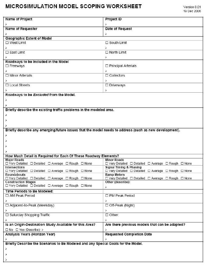
To assist regional offices in conducting microscopic simulation analysis, WisDOT developed the Microsimulation Model Scoping Worksheet which is used by Bureau of Highway Operations to determine whether or not microscoping simulation is a) appropriate and b) technically feasible. The scoping worksheet is attached.
[12] This case study references the document Guidelines for Developing Work Zone Transportation Management Plans (January 2008) prepared by the Wisconsin Department of Transportation.
Table of Contents | Previous | Next