
Work Zone Coordination in Washington State
The Washington State Department of Transportation (WSDOT) facilitates a collaborative, multi-agency construction traffic planning effort focused on communication and coordination amongst projects and agencies in the state. These coordination efforts include long-term, mid-term, and short-term information sharing, supported by tools developed by WSDOT.
As a result of work zone coordination efforts, WSDOT and the local and regional agencies involved recognize benefits:
- Reduced potential for conflicting lane/road closures.
- Regularly scheduled meeting time for key personnel to discuss closures.
- Enhanced public information resources, such as maps posted to the WSDOT Web site, that provide a big picture of the coordinated closures.
- Enhanced public information dissemination, reaching a greater number of stakeholders across multiple affected locations.
Mid- to Long-Term Coordination Efforts
Mid- to-long term construction coordination includes projects planned more than three months out and typically no more than two years into the future. Each construction season, WSDOT analyzes upcoming projects to identify construction traffic "hot spots". Hot spots are areas where several roadway construction projects occur in close proximity at the same time and require increased multiagency coordination. This analysis is done more than a year in advance of the construction (e.g., analysis of the 2015 construction season would occur in the fall of 2013, with coordination meetings in spring 2014). The hot spot coordination meetings bring together project staff and partners to help project teams minimize and mitigate traffic impacts well in advance of construction. The identified hot spots are updated each quarter and if significant changes to schedules or impacts occur the analysis is revisited.
Some regions may meet more often in between the annual construction meetings to further discuss and plan for upcoming projects. The Seattle area is a particularly hot spot of construction with a team of engaged staff meeting every two months to share information and identify risks and opportunities in the mid-term. Representatives from the affected cities, transit agencies, ports, and counties typically attend these meetings. The regular meetings are an easy way for the different offices to coordinate high impact lane closures and public information dissemination well in advance. Lane closure information is emailed to partners and made available at WSDOT's Web site.
Each quarter WSDOT also gathers traffic impact information for state, local, and private construction projects and events affecting roadways in eight western Washington counties. This information is entered into WSDOT's Construction Impact Analysis (CIA) tool (described below) and used to create maps and Gantt charts to support coordination efforts. The materials can be customized to look at specific geographic areas, time periods or severity of impact. The quarterly updates including identified hot spots are posted to the WSDOT Web site and provided to project teams, ensuring up-to-date information is available.
Short Term Coordination Efforts
Short-term efforts consider construction over the next three months with a focus on the next three weeks. In the Seattle area affected parties meet weekly to coordinate specific project details and provide an opportunity to address issues in work zones. Information is shared with affected businesses and major sports venues. The short term coordination is an easy way for maintenance staff to see which activities they can perform during the already planned lane closures to expedite work, reduce overall impacts to traffic, and save money.
WSDOT Construction Impact Analysis (CIA) Tool
Mid-to long-term coordination is supported by the CIA tool, a web-based application developed by WSDOT Information Technology staff that tracks estimated traffic impacts on the state and local levels for future construction, maintenance, and special events (sports games, marathons, concerts, etc.). This information is also shared with the maintenance staff to see if they can use the same lane closures to get maintenance activities accomplished, which can reduce some maintenance of traffic set-ups, increasing safety and reducing costs. WSDOT uses the CIA tool to produce customized maps and Gantt charts that help analyze impacts on the transportation system as a whole. The tool provides an effective way to manage and present large quantities of ever-changing data in ways that inform decision making.
WSDOT hopes to be able to expand the CIA tool for use in short-term coordination and public communications. Since WSDOT developed the CIA tool in-house, it could be made available to other interested agencies.
Examples of a map and a Gantt chart created with the CIA tool for the Seattle region are shown below.
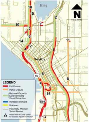
Map of the Seattle region, created by the Construction Impact Analysis tool.
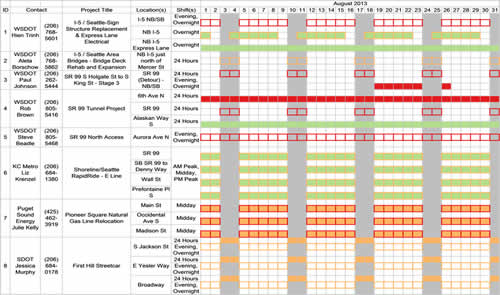
Gantt chart for the Seattle region, corresponding with the map shown above, created by the Construction Impact Analysis tool.