Empirical Studies on Traffic Flow in Inclement Weather
4.0 Data Collection
This section summarizes the weather and traffic field data collection used in the research study. A description of the data sources is followed by a discussion of the dataset construction and data analysis.
4.1 Field Data Description
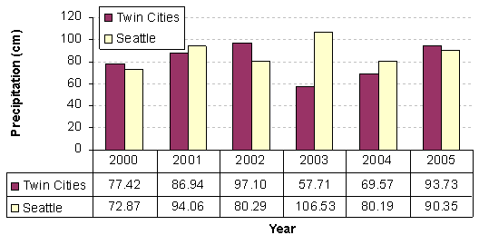
The data used in this study were obtained from three major metropolitan areas in the U.S.: the Twin Cities, Minnesota; Seattle, Washington; and Baltimore, Maryland. For each city two sets of data were obtained for the analysis: traffic data and weather data. Traffic data included traffic stream speed, flow, and density estimates obtained from inductive loop detectors (in the case of Seattle and the Twin Cities) or microwave radar detectors (in the case of Baltimore). Weather data were available from two sources; the Road Weather Information System (RWIS) stations operated by DOTs, and the Automated Surface Observing System (ASOS) stations located at airports. An initial analysis of RWIS data in the Twin Cities Area revealed that the precipitation and visibility readings were either missing or invalid. Consequently, only the ASOS data were utilized for the entire analysis in order to maintain a level of consistency across the various locations. For each study area two years worth of data were utilized for the analysis. The highest total precipitation year was selected for the analysis for Seattle and the Twin Cities, respectively along with the most recent year of data. In the case of Baltimore, the latest data were used for the analysis. Using this criterion the following years were selected for the study; 2002 and 2004 for the Twin Cities, 2003 and 2004 for Seattle, and 2002 and 2003 for Baltimore. The analysis included data for 2004 because this represented the latest available five-minute weather data at the time of the study for the Twin Cities and Seattle Areas. The analysis also included data for 2003 and 2002 because these years had the highest annual precipitation rates in the five-year timeframe for which weather data were available, as illustrated in Figure 4.1. In the case of Baltimore the analysis was confined to 2002 and 2003 because traffic and weather data were only available for these two years.
Figure 4.1 Annual Precipitation Rates for Twin Cities and Seattle
This section briefly describes the weather and traffic data used in the analysis.
Weather Data
The weather data used for all cities were obtained from the ASOS system. This system is sponsored by the Federal Aviation Administration (FAA), National Weather Service (NWS), and the Department of Defense (DOD). ASOS provides weather observations which include: temperature, dew point, wind, altimeter setting, visibility, sky condition, and precipitation. Five hundred sixty-nine (569) FAA-sponsored and 313 NWS-sponsored ASOS stations are installed at airports throughout the USA. The weather reports by ASOS that were used in this study were of METAR type (Aviation Routine Weather Reports) and contained precipitation type, precipitation intensities (inch/h), visibility readings (mile), at five-minute intervals. ASOS also provided other climatic parameters such as temperature, dew point, wind, altimeter setting, and sky condition, however these factors were not considered in this study. The ASOS stations that were used in this study were Minneapolis-St. Paul International Airport, Seattle-Tacoma International Airport, and the Baltimore-Washington International Airport. The following paragraphs briefly describe visibility and precipitation readings from the ASOS stations.
ASOS visibility measurements were performed at 30-second increments using a forward scatter sensor to compute one-minute average extinction coefficients (sum of the absorption and the scattering coefficients). For this purpose, a photocell that identified the time-of-day (day or night) was used to select the appropriate equation for use in the procedure. The ASOS system computed a one-minute average visibility level that was used to compute a 10-minute moving average (MA) visibility level. This value was then rounded down to the nearest reportable visibility level. ASOS visibility was reported in 0.4-km (0.25-mi) increments up to 3.2 km (2 mi) then at 1.6 km (1 mi) increments to a maximum of 16 km (10 mi). Visibilities greater than 16 km were reported as 16 km and values less than a 0.4 km were recorded as a 0.4 km visibility level.
Four intervals were used to represent different levels of visibility observations: less than 0.8 km (0.5 miles), 0.8 to 1.6 km (0.5 to 1 miles), 1.6 to 4.8 km (1 to 3 miles), and greater than 4.8 km (3 miles).
ASOS used precipitation identification sensors to determine the type of precipitation (rain, snow, or freezing rain). Precipitation intensity was recorded as liquid-equivalent precipitation accumulation measurements using a heated Tipping Bucket (HTB) gauge. The HTB has a resolution of 0.025 cm (0.01 in) and an accuracy of ±0.05 cm (±0.02 in) or 4 percent of the hourly total; whichever is greater.
Rain intensities were divided into three categories: less than 0.025 cm/h (0.01 inch/h), 0.025 to 0.64 cm/h (0.01 to 0.25 inch/h), and greater than 0.64 cm/h (0.25 inch/h). Similarly, snow intensity data were also grouped into three categories: less than 0.13 cm/h (0.05 inch/h), 0.13 to 0.25 cm/h (0.05 to 0.1) inch/h, and greater than 0.25 cm/h (0.1 inch/h). These categories are consistent with previous studies (Agarwal et al. 2005).
Table 4.1 shows the different combinations of visibility and precipitation intensities that were used in this study.
Table 4.1 Precipitation/Visibility Combinations Considered
Condition |
Less Than |
0.8 to 1.6 km Visibility |
1.6 to 4.8 km Visibility |
Greater Than 4.8 km Visibility |
|---|---|---|---|---|
D: No Precipitation |
Yes |
Yes |
Yes |
Base Case |
S1: Snow: ≤ 0.127 cm/h |
Yes |
Yes |
Yes |
Yes |
S2: Snow: 0.127-0.254 cm/h |
Yes |
Yes |
Yes |
Yes |
S3: Snow: >0.254 cm/h |
Yes |
Yes |
Yes |
Yes |
R1: Rain: ≤ 0.025 cm/h |
Yes |
Yes |
Yes |
Yes |
R2: Rain: 0.025-0.64 cm/h |
Yes |
Yes |
Yes |
Yes |
R3: Rain: > 0.64 cm/h |
Yes |
Yes |
Yes |
Yes |
Traffic Data
Traffic data were extracted from data reports of study areas’ freeway detector systems. Each study area used different data collection technologies and temporal aggregation resolutions, however, at all three locations traffic data were gathered on a lane-by-lane basis. A time interval of five minutes was selected for the analysis in order to be consistent with the ASOS weather data resolution. Four, five, and three detector stations were considered in the Twin Cities, Seattle, and Baltimore areas, respectively. The sites were selected based on the following criteria:
- The recorded data provided sufficient coverage for all traffic conditions, i.e., uncongested, around capacity, and congested conditions, to allow a full analysis over all traffic regimes.
- Not within the influence area of merge, diverge, or weaving sections in order to ensure that changes in traffic stream flow were not impacted by lane changing behavior. The influence area of a ramp was considered to be a distance of 400 m (0.25 mi) or less from the ramp.
- If possible, lanes were neither a shoulder nor median lane because behavior in shoulder lanes are impacted by traffic merge and diverge behavior while traffic stream behavior in median lanes could be associated with High Occupancy Vehicle (HOV) restrictions.
- Outside the influence of any incidents. This objective was achieved by screening data using incident information obtained from DOTs. The incident information included time of detection, time of clearance, and the location of the incident.
- As close as possible to ASOS stations.
Twin Cities, Minnesota
Traffic data were available from approximately 4,000 single loop detectors installed on freeway lanes within the Twin Cities area. Each detector recorded the volume and occupancy every 30 seconds. As part of the analysis, the data were aggregated at five-minute time intervals in order to be consistent with the ASOS weather data temporal resolution. The traffic stream variables were computed using equations [3], [4], and [5].
![]() [3]
[3]
![]() [4]
[4]
![]() [5]
[5]
where q is the traffic stream flow rate (veh/h/lane), k is traffic stream density (veh/km/lane), u is the space-mean speed (km/h), T is the polling interval (s), n is the number of vehicles observed during a polling interval, O is the detector occupancy during a polling interval (percent), and D is the calibrated detector field length which includes the length of the detection zone plus an average vehicle length (m).
A set of four detectors in the vicinity of the ASOS sites were selected based on the previously described site selection criteria. The closest detector was 5.4 km (3.4 mi) from an ASOS station while the farthest detector was 15 km (9.3 mi) from the weather station. Table 4.2 provides further information on the detectors in the Twin Cities area that were utilized in this study. All selected detectors were located on the middle lane of three-lane sections. Two of the detectors (D2463 and D2390) were in different directions of the same section of freeway.
Table 4.2 Detector Summary Information
Detector |
Location |
Lane |
Detector Type |
No. of Lanes |
Distance to |
ddown (km) |
dup (km) |
|---|---|---|---|---|---|---|---|
D3294 |
Twin Cities |
Middle |
Single loop |
3 |
5.4 |
2.0 |
1.5 |
D2390 |
Twin Cities |
Middle |
Single loop |
3 |
15 |
0.4 |
1.35 |
D2463 |
Twin Cities |
Middle |
Single loop |
3 |
15 |
1.35 |
0.4 |
D2387 |
Twin Cities |
Middle |
Single loop |
3 |
14.6 |
0.9 |
0.45 |
042DS_T2 |
Seattle |
Middle |
Dual loop |
3 + HOV |
4.7 |
1.4 |
1.3 |
042DN_T2 |
Seattle |
Middle |
Dual loop |
3 + HOV |
4.7 |
0.9 |
1.4 |
333DN_T2 |
Seattle |
Beside HOV |
Dual loop |
2 + HOV |
7 |
1.9 |
1.0 |
333DS_T2 |
Seattle |
Beside HOV |
Dual loop |
2 + HOV |
7 |
0.45 |
2.1 |
024DN_T2 |
Seattle |
3rd from shoulder |
Dual loop |
4 + HOV |
11.8 |
1.1 |
2.6 |
316008_L2 |
Baltimore |
2nd from median |
Microwave |
4 |
18.7 |
2.4 |
1.6 |
403018_L2 |
Baltimore |
2nd from median |
Microwave |
4 |
25 |
0.9 |
1.5 |
403023_L2 |
Baltimore |
2nd from median |
Microwave |
4 |
15 |
0.6 |
1.4 |

Seattle, Washington
The Washington State Department of Transportation (WSDOT) operates a Traffic Management Center (TMC) in the Seattle metropolitan area that collects and records traffic data on the Seattle freeway network. At the time of the study traffic data were gathered by a network of single and dual loop detectors. The recorded data were publicly available through the Traffic Data Acquisition and Distribution (TDAD) project’s web site, which was developed by the University of Washington.
From more than 700 available dual loop detectors, five sites were selected based on the selection criteria described earlier. For some of the detectors, data for multiple lanes were included in the analysis, as summarized in Table 4.2. The distance of the selected sensors from the ASOS stations ranged between 3.2 and 11.8 km (2.0 and 7.3 mi). The frequency of data recording was 20 seconds, and each dual loop detector measured traffic stream time-mean speed and flow at 20-second intervals. The data were then aggregated into five-minute intervals in order to be consistent with the ASOS data collection temporal resolution. The five-minute speed conversion was performed using a flow-weighted harmonic mean of 20-second speed observations in order to compute space-mean speeds (Rakha and Zhang, 2005). The traffic stream density was computed from flow and speed measurements using the fundamental traffic flow relationship (Equation [5]).
Baltimore, Maryland
Baltimore’s traffic data were provided by The University of Maryland’s Center for Advanced Transportation Technology Laboratory (CATT Lab). The CATT Lab has a high-speed connection with the Maryland State Highway Administration’s (SHA) and the Coordinated Highway Action Response Team (CHART). CHART utilizes a network of microwave radar detectors to collect traffic counts and speed measurements on the highway network around Baltimore. The provided traffic data files contained volume and speed measurements at a five-minute temporal resolution.
It was observed that the percentage of missing records in traffic data was relatively high for Baltimore (between 20 to 75 percent missing records versus 1 percent and 2 percent for the Seattle and Twin Cities, respectively). To maintain a good coverage for all the weather and traffic conditions it was decided to discard the recording stations which had more than 40 percent of their records missing. Considering this additional selection condition, only three detector sites were found to satisfy all the selection criteria. Table 4.2 summarizes the characteristics of the three selected detectors in the Baltimore study area. It should be noted that these stations were relatively far from the Baltimore-Washington International ASOS station (15 to 25 km / 9.3 to 15.5 mi).
4.2 Dataset Construction and Data Analysis
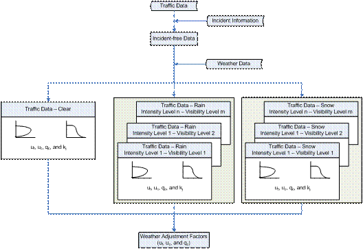
After preparing the weather and traffic data separately, the two data sets were merged to form a dataset that contained visibility, precipitation, traffic flow, density, and speed records for each five-minute time interval, as demonstrated in Figure 4.2. This dataset was then used to derive weather adjustment factors for the various parameters.
Figure 4.2 Data Construction Overview
The base case was considered to be the no precipitation condition with a visibility greater than or equal to 4.8 km (3.0 mi), given that this represented the highest visibility scenario within the dataset. The construction of each dataset involved combining data over multiple days until coverage of the uncongested and congested regimes was achieved.
In order to achieve sufficient observations to conduct a statistical analysis, the data corresponding to each cell of Table 4.2 were grouped in a manner to provide as many replications as possible. Each group contained as many days worth of data as necessary to provide a good coverage for all traffic regimes. Consequently, a seven-day period was considered for the initial grouping which was selected to ensure sufficient data coverage for the full-range of traffic conditions. In the event that a seven-day grouping did not provide sufficient data, additional days were included until sufficient data coverage was achieved. Due to the variable nature of traffic over a network, the number of datasets for each visibility/precipitation range at each detector site was different, as discussed later in Tables 5.2, 5.3, and 5.5.
The next step was to estimate the key traffic flow parameters for each multiday group. For this purpose the SPD_CAL software was utilized for the analysis. The output of each run of the software provided an estimate of the four key traffic flow parameters for each multiday group. Weather adjustment factors were computed for three of the key parameters (uf, uc, and qc) given that jam density (kj) was found to be insensitive to weather conditions, as would be expected. The weather adjustment factor was computed as the ratio of the key parameter under existing weather conditions relative to the base case key parameter.
| Previous Section | Next Section | Home | Top