Integrating Computer-Aided Dispatch Data with Traffic Management CentersChapter 3. Evolution of Computer-Aided Dispatch Data SharingEfforts to integrate computer-aided dispatch (CAD) data with traffic management center (TMC) systems date back to the early 2000’s. As TMCs and traveler information systems expanded to include data sources beyond the agency intelligent transportation systems (ITS) and networks, and as transportation operations agencies recognized the critical role that law enforcement and public safety data played in incident management response processes, there was increasing interest in facilitating more efficient ways to obtain this important CAD data. This chapter presents how CAD data sharing capabilities between public safety and transportation operations have evolved and includes case studies of successful data sharing relationships. Early Computer-Aided Dispatch Traffic Management Center Data Sharing StudiesA foundational study conducted by the National Cooperative Highway Research Program (NCHRP) in 2004 identified strong synergies between public safety and transportation operations for common goals of safer response to incidents on the road network and that information sharing was a mutual core value of both public safety and transportation operations. The study found that even manual efforts to share traffic incident management (TIM) data between responder agencies and transportation operations agencies fostered greater cooperation and collaboration.11 At the time of that study, information sharing included co-located law enforcement and transportation operations for in-person coordination, some sharing of common radio systems, and shared CAD data with view-only access to limited CAD details. State DOTs that were interviewed as part of the NCHRP study cited proprietary systems (for law enforcement and transportation operations), lack of CAD data sharing standards, and institutional barriers as key challenges impacting data sharing. This study led to two field operational tests in Washington State and Utah. Current State of the PracticeMore than half of State DOTs reported that they have access to some level of law enforcement incident data. This includes a range of methods to access this CAD data, including view-only access to CAD data feeds, manual notifications of incidents, or through direct CAD data feeds to TMC software. Figure 4 shows the current status of CAD data sharing throughout the United States. 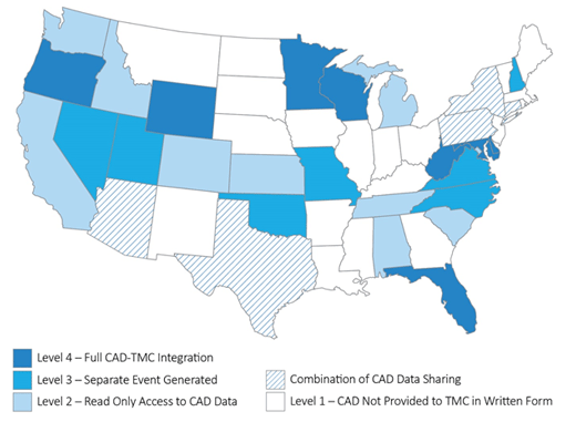
Figure 4. Map. Current status of Computer-Aided Dispatch (CAD) and Transportation Management Center (TMC) integration. Past challenges and barriers have often pointed to several potential issues that have impacted agencies’ abilities to share CAD data, including:13
Security of Sensitive Computer-Aided Dispatch DataToday’s CAD and TMC software can largely address prior technology compatibility and data integration challenges, and voluntary data standards promote greater interoperability of data between law enforcement and transportation systems. There remain challenges with information sensitivity and data security. For example, Criminal Justice Information Systems (CJIS) and the Health Insurance Portability and Accountability Act (HIPAA) have provisions for handling or limiting access to personally identifiable information (ODOT), some of which might be contained in public safety CAD incident details. There are usually standard menu data fields, but many CAD systems also include freeform text entries where dispatchers capture varying levels of incident information. These free-form fields could contain potentially sensitive information. Limiting access at TMCs to pertinent transportation-related data can help to alleviate concerns regarding CJIS and HIPAA requirements, as can proper training of TMC operators who will be accessing CAD data. For example, the Federal Bureau of Investigation’s CJIS Security Policy describes how data exchange agreements are used to outline specific data that is to be shared, how this data will be transmitted, and any limitations on use of data by the recipient (in this case, the TMC).14 Establishing these parameters helps to safeguard CJI data security requirements can limit liability of the transportation operations agency. Another strategy to mitigate CJIS concerns is for law enforcement to provide TMCs with a data feed that only includes traffic and vehicular incidents and limits the data fields shared to incident type, types of vehicles involved and location, but limits details such as severity, injuries, license plates, and other potentially sensitive data. Some States, such as California, require additional background checks for TMC operators that will have access to incident data generated by CAD systems. Many CAD system vendors provide training materials and resources that can support training program, including basic security awareness training, and specific training for IT and network management personnel. The following case studies highlight how Minnesota and Florida have focused on increasing and improving CAD data sharing between State Police agencies and transportation operations. These examples show how both States leveraged technology enhancements as well as collaborated to find solutions to address some of the common challenges that impact CAD data sharing. Additional brief case study examples are also included. Successful Practice: Minnesota Shared Computer-Aided Dispatch SystemThe Minnesota DOT (MnDOT) and the Minnesota State Patrol (MSP) have a long history of collaborating to improve incident detection, response, management, and performance analysis. MnDOT and MSP have incrementally increased the CAD-TMC integration over the last 20 years. In 2001, MnDOT had a view-only CAD terminal at its TMC where operators could view MSP incidents. In 2003, the Regional TMC (RTMC) was built in Roseville, which co-located MnDOT TMC operations, MSP dispatch, and MnDOT maintenance. Co-locating these agencies provided a strong foundation for ongoing system and operational collaboration. In 2008, MnDOT and MSP implemented a full TMC integration with the MSP CAD. MnDOT was expanding its traffic management system coverage area and responsibilities but was not increasing the number of operations staff; integrated CAD provided an added level of efficiency for TMC staff. Software privileges allowed MSP to filter which information TMC operators could view and access, which maintains the privacy of sensitive CJIS and HIPAA data. As part of the agreement with MSP for the TMC to be fully integrated, the MSP allowed the TMC staff and Freeway Incident Response Team (FIRST) staff to view and enter specific comments into MSP-created CAD events which the TMC could use at later points to obtain benchmark times. The MnDOT TMC and the FIRST staff can create their own events within the MSP CAD system, such as FIRST service patrol responses and service calls. A 2012 enhancement allowed for more automated data export to MnDOT’s ATMS, traveler information services and data analysis tools. MnDOT funded several technology enhancements that enabled increased CAD usage by MnDOT staff, including TMC and FIRST. This included computers and software on board the FIRST vehicles, the CAD mobile software license and other supporting infrastructure to allow FIRST vehicles to run and access the MSP CAD. FIRST and TMC uses the same hardware and software as MSP, but MSP troopers have access to more data within CAD which is filtered from FIRST and the TMC. Figure 5 shows an active FIRST response unit. 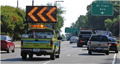
Figure 5. Photo. Minnesota Department of Transportation Freeway Incident Response Safety Team response team. The TMC also monitors the MSP radio dispatch and can immediately use closed-circuit television (CCTV) cameras to verify, confirm, and assess incidents. Valuable information about the incident scene and exact locations can be relayed to responders en route, helping them to formulate strategies even before they arrive to better position themselves at the incident scene. Real-time views through CCTV supports the ability to upgrade or downgrade response and communicate that information to responders. With this integration and agreement between the agencies, MnDOT became an allied agency on MSP’s CAD system. The live data feed and the incident comments field are actively shared between the agencies, providing a two-way street for including relevant response and incident details. Information provided in the real-time feed includes latitude/longitude, event type, start and close times, real-time location of response vehicles, and TMC operator-entered remarks. Integrated CAD in Minnesota has allowed for more robust performance tracking and access to important reference points. MnDOT Maintenance uses CAD data to retrieve case numbers for incidents that have caused damage to state property. Having the specific case number and details about the incident has helped to support restitution billing through insurance. Another key example is the capability for FIRST SSP to track which vehicles they have assisted and frequency of assists. This has helped to identify individuals that have repeatedly availed themselves of the state’s emergency roadside assist program. Successful Practice: Florida Integrated Computer SystemsFlorida has worked with a shared view of CAD since the early 1990s. Co-location of dispatch and TMC began in the mid 1990s, and the first iteration of shared CAD information was a media viewer, which provided filtered details but refreshed only every five minutes. The Florida Highway Patrol (FHP) deployed a new generation of CAD in 2001, and while the updates were still not real-time, the event list was heavily relied upon by the Florida DOT (FDOT) TMCs. In 2005, the CAD vendor developed and deployed a new CAD viewer that improved the incident data refresh rate to every minute. The next iteration of CAD in Florida provided interactive incident mapping to the public. Technology improvements allowed location information to be more precise, and the freeway service patrol (Road Rangers) also began contributing information to the CAD system. The FDOT created an Incident Detection System (IDS) to handle CAD content and automatically create alerts for TMC operators who would be informed of CAD incidents, based on their geographic location. The alerts allowed CAD incidents to create ATMS events with the push of a button, populating relevant data fields for event type, location, time stamps, etc. Florida faced some technological challenges integrating and distributing data from seven separate regional FHP servers and 12 Regional TMC servers. TheIDS helped the agencies solve the challenges presented by distributed systems and geography. An example of alerts FDOT TMC operators receive from the FHP CAD system is shown in figure 6. Florida’s success is evidenced in the fact that approximately 42 percent of the more than 91,000 annual traffic crashes in the State DOT ATMS originate from FHP CAD. 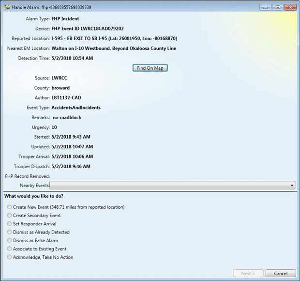
Figure 6. Screenshot. Example alert sent to Florida Department of Transportation Traffic Management Center (TMC) from Florida Highway Patrol Computer-Aided Dispatch (CAD). Additional Successful Practices
Ongoing Efforts to Expand Computer-Aided Dispatch-Traffic Management Center Data IntegrationThe Federal Highway Administration (FHWA) and other agencies continue to focus on expanding awareness of the benefits of CAD integration. Through industry forums, multi-agency meetings, national webinars and project activities, there continues to be a growing body of research and support for sustaining investment in CAD data integration. Every Day CountsAs part of the fourth round of the Every Day Counts program (EDC4), one of the strategic focus areas centered on TIM data and using TIM data for more robust performance measures. EDC4 emphasized the importance of data to current and future TIM programs, including integrated CAD, electronic crash reporting and tools to streamline data collection and analysis. Three key TIM measures that would showcase the value of the TIM data: Roadway Clearance Time, Incident Clearance Time, and Secondary Crashes were central to the EDC4 TIM data innovation. The EDC4 TIM data initiative emphasized how relatively low-cost technology investments, such as enhancing existing CAD systems, improving mobile data and strategies for harnessing existing data could boost agencies’ ability to track and report on key performance measures. TIM measures have the potential to pinpoint where specific investments—such as TIM strategies, partnerships, and resources—could have the most impact in improving safety and mobility.15 The EDC6 program launched in late 2020 and includes a Next-Generation TIM focus, emphasizing training, technology, and data to improve TIM on local roadways.16 The EDC6 Next-Generation TIM innovation builds on efforts by the FHWA, state and local agencies and the responder community to integrate proven, yet under-utilized approaches to advance TIM. CAD integration, Unmanned Aerial Systems (UAS), video sharing, and responder to vehicle alerts are examples of technology approaches that can help agencies improve efficiency of their TIM programs and activities. New and innovative TIM training and distribution approaches supports institutionalizing national best practices among responder groups, including agencies that work on local and rural roads. The Eastern Transportation CoalitionThe Eastern Transportation Coalition (formerly known as the I‑95 Corridor Coalition) has a long history of collaborative, multistate TIM initiatives. In October 2017, the Coalition hosted a webinar attended by more than 40 agencies, software developers, universities, and consultants to discuss lessons learned and challenges surrounding CAD-TMC data integration. Following the webinar, a two-day workshop was held in 2018 and brought together 20 transportation operating agencies to identify successful practices and strategic focus areas to advance CAD-TMC integration. All participating States reported some level of communication/coordination between public safety agencies and State DOTs on incident management, including via voice, phone call, and radio. Experiences were shared from those States with automatic CAD data feeds into TMC systems and those in various stages of planning for CAD integration. Key benefits identified included:
Challenges and barriers identified by workshop attendees included willingness and support from public safety agencies for sharing data, lack of formalized partnerships or guidance for data sharing, CJIS requirements for handling sensitive data, and funding. Talking Traffic Incident Management Webinar SeriesIn partnership with the National Operations Center of Excellence, FHWA moderates monthly TIM-focused webinars that highlight innovative practices, State and regional TIM program advancements, and TIM training updates. There is a key recurring focus on sharing information on TIM data and performance analysis. Topics have included emerging data sources for TIM (such as crowdsourced data), States’ approaches to crash analysis, CAD-TMC data integration, cross-cutting TIM performance management programs, and other related topics.17 11 NCHRP Report 520, Sharing Information between Public Safety and Transportation Agencies for Traffic Incident Management, 2004. [Return to footnote 11] 12 Federal Highway Administration, Expanded Use of Integrated Computer-Aided Dispatch, Task 3: Business Case, April 2019. Map updated in 2021. [Return to footnote 12] 13 Federal Highway Administration, Expanded Use of Integrated Computer-Aided Dispatch, Task 3: Business Case, April 2019. [Return to footnote 13] 14 Criminal Justice Information Services (CJIS) Security Policy, version 5.9, 6/01/2020, p. 15. [Return to footnote 14] 15 Federal Highway Administration, Every Day Counts: An Innovation Partnership with States, EDC–4 Final Report. April 2019. [Return to footnote 15] 16 Federal Highway Administration, Every Day Counts 6, Next Generation TIM. [Return to footnote 16] 17 National Operations Center of Excellence, Talking TIM Webinar Series. (Accessed October 2020.) [Return to footnote 17] |
|
United States Department of Transportation - Federal Highway Administration |
||