Integrating Computer-Aided Dispatch Data with Traffic Management CentersChapter 2. Sharing Data to Improve Traffic Incident ManagementIncident DataPublic safety agencies, and particularly law enforcement, collect a wide range of data, both real-time and historical. While a computer-aided dispatch (CAD) event is active, data is dynamic and updated continuously to capture time stamp and additional details as they become available. Time-based data from public safety agencies is viewed as the most accurate depiction of incident events and activities. Modern CAD systems can integrate location-based data, such as caller location (using Geographic Information Systems (GIS) capabilities and linking to cell phone tower locations2), and apply Artificial Intelligence capabilities, including audio analysis, speech-to-text, automatic call/incident categorization, and other functions. There are tools within today’s CAD systems that help to supplement operator interactions and data entry, such as automatically populating standard data fields. These tools can also be used to better understand key words and phrases used by callers, as well as generate detailed trend and analysis reports based on incident types, incident locations, and other parameters. The CAD systems are rarely standalone communications tools, and they are typically linked within a broader suite of Record Management Systems (RMS) that includes crash reporting, evidence management, external database queries, mobile data device systems, and other functions. These systems usually offer some degree of customization to meet specific agencies and data fields needed. Public safety CAD can provide such a wealth of timely and accurate incident data that stakeholders seek ways to better share and use that information, specifically with transportation data systems, like Advanced Traffic Management Software (ATMS) used in Traffic Management Centers (TMC). ATMS systems are analogous to public safety CAD, just with a transportation angle. Systems used by transportation agencies are also event-based, extensively using location and time data elements to coordinate activities, but primarily limited to roadways. Incident Data Standards and Data InteroperabilityIn addition to agency-written CAD programs, there are dozens of different vendors that provide and support CAD and RMS systems for public safety agencies. Voluntary data standards and specifications can help provide a common platform of functionality and support interoperability, such as center-to-center communications, including those operated by State Departments of Transportation (DOT). Standards help to promote consistent data formats and structures, and support greater automation of data queries and improve automated data sharing processes, thereby limiting the amount of customized or proprietary data integration and management that would otherwise be required. Using standards helps promote both cost and resource efficiencies. CAD standards efforts that are improving data access, storage and data management efficiencies for law enforcement agencies include:
The transportation community has also been active in developing standards to promote data sharing and interoperability. Standards that are relevant to Traffic Incident Management (TIM) include:5
By leveraging available standards, both CAD and ATMS system developers can create innovative technology solutions that can support interoperability and information exchange across platforms. Key Benefits of Sharing Computer-Aided Dispatch Incident DataSharing CAD data can be mutually beneficial for public safety and transportation operations, and has been shown to reduce time to respond to and clear incidents and reduce risk of secondary crashes. The primary benefit of reducing incident response and duration times is the improved safety for and reduced risk to responders, including law enforcement, fire, emergency medical, transportation operations and tow operators. Specific benefits cited by several case studies8 show demonstrated improvements to safety, reduction in incident clearance time, and improved resource efficiency, including:
Chapter 4 provides additional details on key benefits of CAD integration and data sharing. Relevant Data for Transportation OperationsData within public safety CAD systems is generally robust and covers a wide range of incidents and call types. Transportation operating agencies, and TMCs in particular, are not typically interested in those incidents that do not directly relate to traffic or road impacts, so the amount of data sought by transportation agencies is a fraction of what is contained within the CAD systems. Transportation operating agencies are primarily interested in the following types of data:
Public safety dispatchers gather this information from 9-1-1 callers, on-scene personnel, and allied agencies. Automated data types assigned in CAD include location, incident type, creation time, dispatch, arrival, and clearance times of the units to which the CAD owning agency is connected. Information such as lanes blocked, lanes cleared and secondary crashes require a manual entry and will not be automatically logged unless entered by a dispatcher or an officer in the field. Law enforcement CAD will not include data from other agencies about arrivals, on-scene response activities or clearance times; that information will be captured in that responding agency’s corresponding CAD system. Unless there is a CAD-to-CAD interface to share that data, it will not be integrated with law enforcement CAD data. Dispatchers update CAD systems as the incident is managed and until it is cleared. Information about any potential support resources from the State DOT, such as service patrol, hazardous materials (HAZMAT) or other response teams could be relayed and requested from on-scene personnel and could be transmitted via a CAD message or through direct request from field personnel or dispatch centers to TMC staff. Information from CAD can also be valuable post-incident, in that it provides an important record of the incident and its impacts. Minnesota DOT noted that it uses CAD data to retrieve case numbers for incidents that cause damage to State property. This information is helpful for any insurance information or restitution billing needs. The TIM timeline, shown in figure 1, identifies the chronology of a traffic incident from when an incident occurs until the time when traffic conditions return to normal. Along the timeline are milestones, including T0 (incident occurs) through T6 (traffic conditions return to normal). The goal of TIM is to shorten the duration between T0 and T6. Incident data sought by transportation agencies aligns with the TIM timeline. 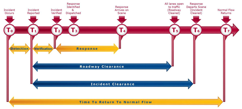
Figure 1. Diagram. Timeline of traffic incident elements. Methods for Sharing Incident DataThere are many ways that agencies can share CAD data. This section describes the levels of incident notifications and CAD data sharing as a function of how it is shared, from a simple phone call to advanced approaches that move data between systems without human intervention. Figure 2 shows the range of methods for sharing incident data between public safety agencies and TMCs, from basic to advanced. The corresponding sections that follow provide a description. 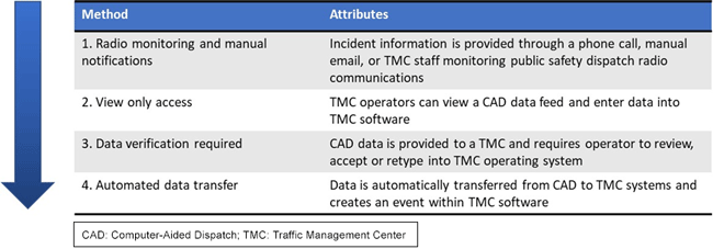
Figure 2. Diagram. Methods of computer-aided dispatch data sharing. Level 1TMC operators are notified of incidents through manual methods, such as a call from a public safety dispatch center or an email alert. Level 1 also includes TMC being made aware of an incident through monitoring public safety communications radios. This method can result in inconsistent notifications, and there could be a delay in obtaining information of the incident, which leads to delay in notifying travelers or dispatching State DOT support resources. At this level, incident updates also are provided (or monitored via radio) and updated manually. TMC operators translate the information that is being provided dispatchers or interpreted from radio communications and enter the information into TMC software to generate an incident event within CAD. Level 2TMC operators have access to a CAD data feed, which could be through a dedicated computer screen or terminal, or a windowed viewer. In some instances, there is a CAD terminal in the TMC but viewing is limited to law enforcement personnel who can then relay notifications to TMC operators. In other instances, the TMC operators can view a filtered data feed that does not include any sensitive incident information. This process relies on co-located communications between on-site officers and TMC operators, or on TMC operators to actively check for incidents and updates. TMC staff must enter information into TMC software to generate an incident event. Level 3CAD data is sent to the TMC and will appear as an alert that the operator needs to acknowledge. This eliminates the need for operators to check a separate window or system for incident alerts or incident updates, but still requires operator action, depending on how the TMC software is configured. TMC staff is typically required to copy and paste relevant CAD details to create an ATMS event. Systems might be configured to automatically interpret some of the fields, such as displaying incident location on a map of assets such as dynamic message signs (DMS). Level 4At this level, the existing traffic management software brings in CAD data with minimal operator action or intervention. Delay between the incident being reported to police and shared with the TMC is minimal. Again, the TMC software may display incident details automatically as alerts or on status maps to assist operators in responding. As the incidents are updated in CAD, details may be automatically shared and updated with TMC systems. In some cases, such as in Minnesota, the TMC can serve as an allied agency with (limited) access to CAD, and the ability to create and manage events within CAD. This option limits the potential for errors or missing data. Traffic Management Center Functions that Rely on Traffic Incident Management DataTMCs are hubs for real-time information about the transportation network. They house a wide range of systems that enable real-time monitoring of systems and roadways, allow operators to enter and track information on planned and unplanned closures, and these systems enable operators to control various intelligent transportation system (ITS) devices, such as closed-circuit television (CCTV) cameras and DMS. The typical role of a TMC is also to facilitate notifications, coordinate among agencies and distribute alerts through traveler information systems. During traffic incidents, TMCs serve a critical function in verifying incidents, assessing impacts to the road network, dispatching State DOT resources (such as incident response teams, hazardous materials crews or safety service patrols), and disseminating information to warn other travelers. A TMC is often responsible for issuing notifications to other agencies and services about the incident and its impacts. TMCs typically include a grouping of individual workstations where operators can monitor and manage multiple systems. A video wall allows several operators to monitor a network, and if there is an incident at a particular location, this can be displayed on the video wall for broader monitoring by State DOT staff in the TMC. Figure 3 shows a typical TMC workstation in an operations room. 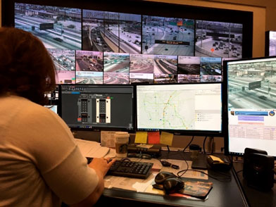
Figure 3. Photo. Traffic management center workstation at the Freeway and Arterial System of Transportation traffic management center, Nevada. Access to real-time incident data is critical to many TMC functions. Because the majority of incidents are initially detected through 9-1-1 calls, the initial incident notification will set a series of processes into motion at the TMC. These processes include TMCs assessing what types of State DOT resources could be needed to support incident response and clearance, assisting the primary responder agency with confirming incident locations, and which alerts and notifications to send to agencies and other motorists through traveler information tools like 5-1-1, social media and traditional media outlets. Other key incident details that enable faster and more effective incident response processes at TMCs include:
These details are important to a wide range of State DOT response processes, and access to continually updated CAD data can improve the quality and accuracy of information with which the TMC is working, limit the need for the TMC to coordinate with busy law enforcement dispatch centers, and enable better resource mobilization of State DOT resources needed to support the incident response. TMC operators that are manually updating information as it unfolds are at risk of not entering pertinent details, missing updates to information, and are already busy monitoring multiple systems during incidents. Integrated CAD data provides a win-win for both public safety and for transportation operations. 2 Scott Harris, “RMS/CAD: Exploring Technology Brings the Future to the Present,” Product Feature, The Police Chief (December 2017): 64–66. Accessed April 2020. [Return to footnote 2] 3 Standard Functional Specifications for Law Enforcement Computer-Aided Dispatch (CAD) Systems, Law Enforcement Information Technology Standards Council, 2006. [Return to footnote 3] 4 ANS 1.110.1-2015 Multi-Functional Multi-Discipline Computer-Aided Dispatch (CAD) Minimum Functional Requirements, Association of Public-Safety Communications Officials International, 2015. [Return to footnote 4] 5 United States Department of Transportation, Intelligent Transportation Systems Joint Program Office, ITS Standards Program, Incident Management Application Areas (accessed April 2020). [Return to footnote 5] 6 Institute of Electrical and Electronics Engineers, (accessed October 2020). [Return to footnote 6] 7 Institute of Transportation Engineers, (accessed October 2020). [Return to footnote 7] 8 Federal Highway Administration, Expanded Use of Integrated Computer-Aided Dispatch, Current Practices in Integrated CAD/TMC Systems, Contract No. DTFH61-16-D-00051, 2019. [Return to footnote 8] 9 “Transportation Management Center Data Capture for Performance and Mobility Measures Reference Manual,” March 2013. (Accessed October 2020.) [Return to footnote 9] 10 I-95 Corridor Coalition (now Eastern Transportation Coalition) CAD and TMS Integration Workshop Summary Report, April 2018. [Return to footnote 10] |
|
United States Department of Transportation - Federal Highway Administration |
||