Research, Development, and Application of Methods to Update Freight Analysis Framework Out-of-Scope Commodity Flow Data and Truck Payload Factors
Chapter 9. Fish
Methodological Approach
As shown in figure 61, the draft process for modeling out-of-scope fishery commodity flows is based on the portion of the supply chain that constitutes the out-of-scope movement. This solely consists of the movement from the port to a facility for cleaning, canning, freezing, or some other processing activity. Once seafood reaches the processing, it is an in-scope movement categorized under North American Industry Classification System (NAICS) code 311 for Food Manufacturing.62
The process would utilize the following data sources:
- Location of Ports and Annual Amount of Commercial Fishery Landings—Data on the location of ports and the amount of commercial fishery landings (tonnage and value) is available from the National Marine Fisheries Service (NMFS) of the National Oceanic and Atmospheric Administration (NOAA).63
- Location of Processing Facilities—Seafood processing facilities are identified by NAICS code 3117 (Seafood Product Preparation and Packaging). The locations of these facilities are identified using the County Business Patterns database from the U.S. Census Bureau. Based on the 2016 County Business Pattern (CBP) data, there are 219 counties with seafood processing facilities.
Key methodological steps include:
- Estimate County-Level Fish Landings/Productions—Port-level landing data from the NMFS was aggregated to the county level using data from the NMFS, which reports landings for the largest ports. State-level data on landings was obtained from the Fisheries of the United States report. Landings at ports for which disaggregate data was available was attributed to the port's county. The balance of landings (i.e., the difference between State totals and the total of the ports with data) was divided among counties with ports for which data were not provided. Consumption zones are also defined at this step in the process which indicate where productions and consumptions take place. These zones largely follow those used by the NMFS for purposes of analyzing and reporting data.
- Estimate County-Level Fish Attractions—Estimate the State and county totals of fish commodities attracted using the location and size of seafood product preparation and packaging establishments. The location and size of seafood product preparation and packaging establishments was estimated using data on the number of establishments by county and their total annual payroll for all employees.
- Distribute Flows Between Counties—Fish commodity flows were distributed to counties based on the location and size of processing plants using a gravity model (see figure 35). Impedance was a function of network distance between counties as captured by the Oak Ridge National Laboratory County Distance database (see figure 36). Unlike the current Freight Analysis Framework Version 4 (FAF4) procedure, fish commodity flows were allowed to cross State boundaries.
- Aggregate to the FAF4 Zone Level—After distribution, individually aggregate the county-level productions and attractions to the FAF4 zone level.
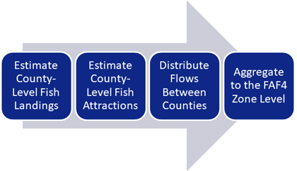 Figure 61. Flow chart. Framework for out-of-scope fish shipments.
(Source: Federal Highway Administration.)
Figure 61. Flow chart. Framework for out-of-scope fish shipments.
(Source: Federal Highway Administration.)
Table 25. States by zone for fish.
| Zone |
States |
| Northeast |
- Connecticut.
- Delaware.
- District of Columbia.
- Maine.
- Maryland.
- Massachusetts.
- New Hampshire.
- New Jersey.
- New York.
- Pennsylvania.
- Rhode Island.
- Vermont.
- West Virginia.
|
| Coastal Southeast |
- Florida (East Coast).
- Georgia.
- North Carolina.
- South Carolina.
- Virginia.
|
| Gulf Coast |
- Alabama.
- Florida (West Coast).
- Louisiana.
- Mississippi.
- Texas.
|
| Great Lakes |
- Illinois.
- Indiana.
- Michigan.
- Missouri.
- Minnesota.
- Ohio.
- Wisconsin.
|
| California |
|
| Pacific Northwest |
|
(Source: Federal Highway Administration.)
Results
Figure 62 depicts the assumed production-consumption zones for fish shipments. These zones were based on the clustering of counties that produce fishery landings. Ten production-consumption zones are defined for the contiguous U.S.: Northeast, Coastal Southeast, Southeast, Southwest, Gulf Coast, Great Plains, Great Lakes, Mountain, California, and Pacific Northwest. In addition to these, Alaska and Hawaii were defined as individual zones. In keeping with the observation that fishery shipments are primarily local, the methodology assumes that out-of-scope (OOS) movements of landed fish are distributed within these zones.
Also depicted in figure 62 are the results of estimated fish landings at the county level. The NMFS Port Landings database and the Fisheries of the United States report provide data on annual estimates of port- and state-level landings by total tonnage. However, the NMFS does not report landings for ports, which requires that county-level totals be estimated.
In total, nearly 4.9 million tons of fish are estimated to have been produced in 2017 as shown in table 26. Of that total, the vast majority of landings are attributed to Alaska at over 62 percent. The Gulf Coast is a distant second at nearly 16 percent and is followed by the Northeast at less than 9 percent. The remaining zones are estimated to have produced approximately 14 percent of fish. Figure 63 depicts the methodology's results for the estimation of fish attractions at the county level.
Table 26. Fish production estimates by region.
| Region |
Tons Produced |
Percent of Total |
| Alaska |
3,019,092.50 |
62.14% |
| Gulf Coast |
767,390.00 |
15.79% |
| Northeast |
411,123.00 |
8.46% |
| Pacific Northwest |
279,227.50 |
5.75% |
| Coastal Southeast |
259,814.50 |
5.35% |
| California |
97,418.00 |
2.00% |
| Hawaii |
17,311.50 |
0.36% |
| Great Lakes |
7,428.00 |
0.15% |
| Mountain |
– |
0.00% |
| Southeast |
– |
0.00% |
| Great Plains |
– |
0.00% |
| Southwest |
– |
0.00% |
| Grand Total |
4,858,805 |
100.00% |
(Source: NMFS.)
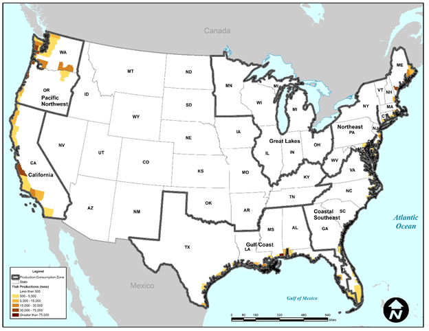 Figure 62. Map. Tons of fish landed (produced) at the county level.
(Source: NMFS.)
Figure 62. Map. Tons of fish landed (produced) at the county level.
(Source: NMFS.)
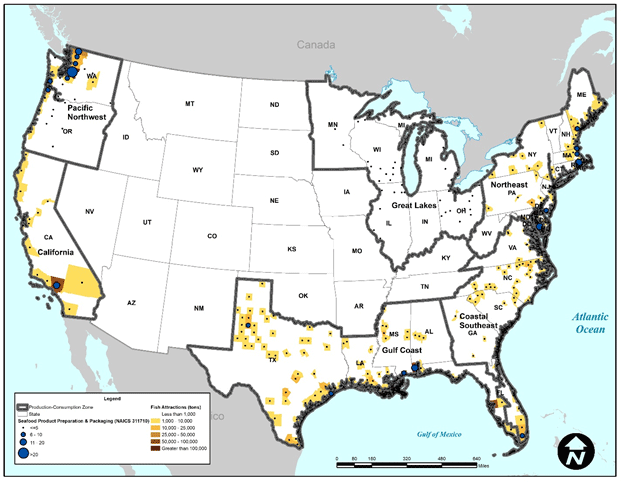 Figure 63. Map. Tons of fish attracted at the county level.
(Source: NMFS; U.S. Census Bureau County Business Patterns, 2016.)
Figure 63. Map. Tons of fish attracted at the county level.
(Source: NMFS; U.S. Census Bureau County Business Patterns, 2016.)
As an example, table 27 shows the results of the analysis of fishery shipments for the Boston-Worcester-Providence, MA-RI-NH-CT Commodity Flow Survey (CFS) Area (MA Part) FAF4 zone. In total, over 78,000 tons of fish are estimated to have an origin or destination within this zone not including internal movements. The results indicate that for the Boston-Worcester-Providence, MA-RI-NH-CT CFS Area (MA Part) zone nearly over 60 percent (over 124,000 tons) of fish flows are internal. Nearly 3 percent (nearly 5,600 tons) of flows are outbound while the remainder (about 37 percent or over 73,000 tons) is inbound.
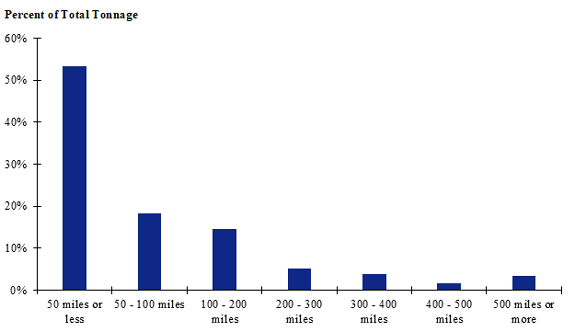
Figure 64 shows the distribution of tonnage by distance for all shipments in the Northeast production-consumption zone. The results indicate that over half of total tonnage travels 50 miles or less and over three-quarters (86 percent) travels 200 miles or less. About 97 percent of total tonnage for the Northeast zone is estimated to travel distances of 500 miles or less.
Table 27. Results for the Boston-Worcester-Providence, Massachusetts-Rhode Island-New Hampshire-Connecticut commodity flow survey Area (Massachusetts Part) freight analysis framework version 4 zone.
| FAF4 Zone |
Outbound from Boston-Worcester-Providence, MA-RI-NH-CT CFS Area (MA Part)—Tons |
Outbound from Boston-Worcester-Providence, MA-RI-NH-CT CFS Area (MA Part)—Percent of Total |
Inbound to Boston-Worcester-Providence, MA-RI-NH-CT CFS Area (MA Part)—Tons |
Inbound to Boston-Worcester-Providence, MA-RI-NH-CT CFS Area (MA Part)—Percent of Total |
| New York-Newark, NY-NJ-CT-PA CFS Area (CT Part) |
– |
0% |
117 |
<1% |
| Hartford-West Hartford-East Hartford, CT CFS Area |
– |
0% |
– |
0% |
| Remainder of Connecticut |
– |
0% |
2,292 |
3% |
| Philadelphia-Reading-Camden, PA-NJ-DE-MD CFS Area (DE Part) |
16 |
<1% |
17 |
<1% |
| Remainder of Delaware |
10 |
<1% |
6 |
<1% |
| Washington-Arlington-Alexandria, DC-VA-MD-WV CFS Area (DC Part) |
– |
0% |
– |
0% |
| Remainder of Maine |
524 |
9% |
35,281 |
48% |
| Remainder of Maryland |
513 |
9% |
133 |
<1% |
| Baltimore-Columbia-Towson, MD CFS Area |
16 |
<1% |
139 |
<1% |
| Washington-Arlington-Alexandria, DC-VA-MD-WV CFS Area (MD Part) |
20 |
<1% |
105 |
<1% |
| Remainder of Massachusetts |
– |
0% |
– |
0% |
| Boston-Worcester-Providence, MA-RI-NH-CT CFS Area (NH Part) |
1,444 |
26% |
3,029 |
4% |
| Remainder of New Hampshire |
– |
0% |
– |
0% |
| Philadelphia-Reading-Camden, PA-NJ-DE-MD CFS Area (NJ Part) |
104 |
2% |
1,466 |
2% |
| New York-Newark, NY-NJ-CT-PA CFS Area (NJ Part) |
298 |
5% |
780 |
1% |
| Albany-Schenectady, NY CFS Area |
– |
0% |
– |
0% |
| Remainder of New York |
561 |
10% |
– |
0% |
| New York-Newark, NY-NJ-CT-PA CFS Area (NY Part) |
859 |
15% |
479 |
1% |
| Buffalo-Cheektowaga, NY CFS Area |
– |
0% |
– |
0% |
| Rochester-Batavia-Seneca Falls, NY CFS Area |
105 |
2% |
– |
0% |
| Remainder of Pennsylvania |
365 |
7% |
<1 |
0% |
| Pittsburgh-New Castle-Weirton, PA-OH-WV CFS Area (PA Part) |
66 |
1% |
– |
0% |
| Philadelphia-Reading-Camden, PA-NJ-DE-MD CFS Area (PA Part) |
95 |
2% |
<1 |
0% |
| New York-Newark, NY-NJ-CT-PA CFS Area (PA Part) |
– |
0% |
– |
0% |
| Boston-Worcester-Providence, MA-RI-NH-CT CFS Area (RI Part) |
602 |
11% |
28,943 |
40% |
| Remainder of Vermont |
– |
0% |
– |
0% |
| Remainder of West Virginia |
– |
0% |
– |
0% |
| Total |
5,599 |
100% |
72,787 |
100% |
(Source: Federal Highway Administration.)
 This graph is based on data from only the Boston Freight Analysis Framework Version 4 (FAF4) zone. Shipments of 50 miles or less make up the largest share while shipments between 400 and 500 miles make up the smallest share.
Figure 64. Bar chart. Distribution of shipment distances for fish in the Boston-Worcester-Providence, Massachusetts-Rhode Island-New Hampshire-Connecticut commodity flow survey area (Massachusetts Part) freight analysis framework version 4 zone.
(Source: Federal Highway Administration.)
This graph is based on data from only the Boston Freight Analysis Framework Version 4 (FAF4) zone. Shipments of 50 miles or less make up the largest share while shipments between 400 and 500 miles make up the smallest share.
Figure 64. Bar chart. Distribution of shipment distances for fish in the Boston-Worcester-Providence, Massachusetts-Rhode Island-New Hampshire-Connecticut commodity flow survey area (Massachusetts Part) freight analysis framework version 4 zone.
(Source: Federal Highway Administration.)
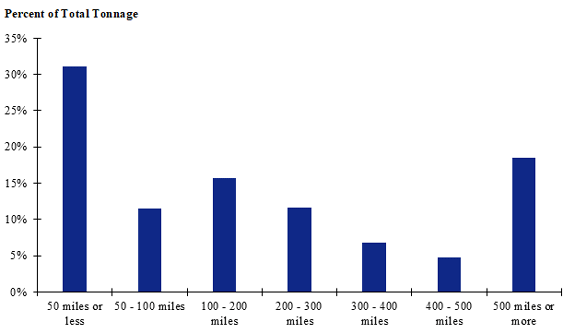 Figure 65. Bar chart. Distribution of shipment distances for fish in the contiguous U.S.
(Source: Federal Highway Administration.)
Figure 65. Bar chart. Distribution of shipment distances for fish in the contiguous U.S.
(Source: Federal Highway Administration.)