Research, Development, and Application of Methods to Update Freight Analysis Framework Out-of-Scope Commodity Flow Data and Truck Payload FactorsChapter 3. Review of Alternative Commodity Flow Survey Out-of-Scope MethodsChapter 3 reviews efforts made by academic institutions, State departments of transportation (DOT), metropolitan planning organizations (MPO), and other Federal agencies to model the movements of out-of-scope commodities. Since the development of the Freight Analysis Framework (FAF), there have been numerous efforts across agencies and academic institutions to capture these flows. In many cases, these efforts were motivated by the economic importance of a particular commodity to local industries or the impact of its transport on local transportation operations. Similar to chapter 2, chapter 3 is organized by out-of-scope (OOS) commodity. For each OOS commodity, relevant case studies related to modeling OOS commodity movements and flows are summarized. These summaries provide background information for the OOS commodity initiative (such as the motivation for the study, its geographic scale, etc.), discuss its data sources, and describe the methodological approach. In order to identify case studies, the project team performed searches in scholarly databases such as Google Scholar, the Transportation Research Board's Transportation Research International Documentation database, and the Bureau of Transportation Statistic's National Transportation Library. Search terms included the names of the out-of-scope commodities (e.g., 'Logging' and 'Municipal Solid Waste'). The search also used the terms 'commodity flows', 'commodity flow database', 'out-of-scope', and variations of these terms. While the search focused on research efforts whose primary goal was the development of a commodity flow database for the out-of-scope commodities, it also included those efforts that attempted to capture the movements of out-of-scope commodities for other purposes. Though these studies did not explicitly attempt to model commodity flows, the insights gained from the modeling of vehicle movements is potentially useful to the Freight Analysis Framework (FAF) 4. This is especially true considering the Freight Analysis Framework Version 4 (FAF4)'s reliance on the discontinued Vehicle Inventory and Use Survey (VIUS) for similar information. Farm-Based ShipmentsDeveloping a Potato Commodity Flow DatabaseBackgroundNational Cooperative Freight Research Program (NCFRP) Report 26: Guidebook for Developing Subnational Commodity Flow Data provided guidance for developing subnational commodity flow databases to meet transportation planning needs at the regional level.52 Among other items, the Guidebook describes methods to develop primary commodity flow data using local data collection along with how to augment local data collection efforts with information from published data sets and commodity flow disaggregation techniques. In developing a sub-national commodity flow database, the Guidebook argues that it is important to understand the supply chain associated with a commodity, including facilities involved in the processing of a commodity and the modes used in transporting a commodity across the supply chain. Though the Guidebook proposes a supply chain-based approach as a method to developing a subnational commodity flow database, it is applicable to OOS commodity flows at the national level as well. One example in the Guidebook, described in detail in this section of the report, is the development of a commodity flow database for potatoes in Washington State. In this example, the Guidebook's insistence on a supply chain-approach to modeling commodity flows is evident. Data SourcesWith guidance from the Washington State Potato Commission, the NCFRP Report 26 team assembled data from several sources including:
MethodologyUsing data from the Washington State Department of Agriculture and the Washington State Potato Commission, the methodology first estimates the amount of potatoes produced in Washington State. The magnitude of potato production is done at the regional level (i.e., multiple counties). While the Washington State Department of Agriculture estimates production totals for fresh potatoes, the Washington State Potato Commission estimates production totals for both fresh and processed potatoes. The total amount of potatoes produced by region is then adjusted to account for harvested crops that were loss or otherwise discarded. Based on data from the Washington State Potato Commission, the loss rate was set at 6 percent. Next, the methodology uses data from the Washington State Potato Commission on the locations of potato processing facilities to estimate the destinations of farm-based potato shipments. It also uses data from the Washington State Potato Commission on the ratios of fresh potatoes to processed potatoes (i.e., frozen, potato chips, and dehydrated) to link the production of farm-based potatoes to in-State destinations. For example, the ratio of fresh potatoes to dehydrated potatoes is 6:1. This implies that every ton of dehydrated potatoes requires as input 6 tons of fresh potatoes. The NCFRP 26 methodology then makes assumptions on the modes used by potato commodities. Based on stakeholder interviews, it was estimated that 25 percent of frozen and 11 percent of all other potato commodities are shipped out of Washington State via rail. The remainder are assumed to be either shipped out to domestic destinations via truck, consumed in Washington State, or exported primarily to Mexico and Canada via truck. Main TakeawaysThe methodology utilizes several of the same data sources and techniques employed in the estimation of farm-based shipments. In particular, both methods rely on data produced by the Agricultural Census. The methods diverge in the use of local data from industry trade groups. In order to shed more light on the movement of potatoes from farms to processing facilities, the NCFRP methodology uses additional data from the Washington State Potato Commission as well as their professional judgment. Given the large number of agricultural products that are included in farm-based shipments (see appendix A), reproducing this type of analysis at the national level on a product-by-product basis is challenging. However, the current FAF4 methodology contains some elements of the NCFRP process in that the productions of farm-based commodities are linked to FAF zones that the Commodity Flow Survey (CFS) recorded a shipment of a product derived from that commodity. Therefore, the NCFRP methodology, or similar, may be appropriate to apply to select farm-based commodities in order to improve their accuracy. Developing a Cattle Commodity Flow DatabaseBackgroundIn December 2017, the Center for Transportation Research (CTR) at the University of Texas at Austin (UT Austin), in cooperation with the Texas Department of Transportation and Federal Highway Administration (FHWA), published a study entitled "Commodity-based Approach for Evaluating the Value of Freight Moving on the Texas' Roadway Network." The major objective of the study was to develop a commodity-based approach for evaluating the value of a select group of commodities moved on the Texas freight network. The research team obtained unique data sources for the select commodities through online investigations and communication with industry representatives. From that data, the project team estimated the quantity of commodities moved from their origins to their destinations, as well as the routes, transportation modes, and vehicle types used. The selected commodities included: cattle, grain sorghum and corn, chickens, and timber, among others. This section of the report describes the data and methodology used by the study to develop cattle commodity flows. Data SourcesThe following data sources were used by the CTR to develop cattle commodity flow estimates:
MethodologyThe methodology developed by the CTR for estimating the commodity flows consists of three distinct movements:
Based on information from cattle industry representatives, the CTR research team determined that ranchers typically send cattle to auction houses within 30 to 40 miles of the ranch. However, there is uncertainty in the proportion of cattle that go down each potential route of the supply chain—auction hose, order-buyer, or feedyard. Though unclear from their description of the methodology, the CTR seems to assume that all cattle are assumed to travel to an auction house before being shipped to a feedyard. To estimate the movement of cattle from the feedyard to the slaughterhouse, the number of cattle at each feedyard (assumed to be the capacity reported on the TCEQ CAFO permits) is summed for each county. If a feedyard was dedicated to a particular slaughterhouse, the number of cattle from that feedyard were removed from the county total and set aside for the Origin-Destination (O-D) flow to the county that contains its dedicated slaughterhouse. For the remainder, it is assumed that the feedyard cattle are shipped to the nearest slaughterhouse. Lastly, the CTR methodology estimates out-of-State movements. The TAHC maintains data from permits issued for cattle shipped into and out of Texas. Though not all cattle that enter or leave the State get permits, the data provides a good approximation of the flow to each State. For international flows, the TAHC monitors the import of cattle from Mexico (by number of head and not by type of cattle). Main TakeawaysThe main takeaway of this case study is that the CTR methodology for modeling flows of cattle (a farm-based commodity) primarily relies on location data of processing facilities as opposed to the FAF4 which relies on shipment distance distribution data from the VIUS. The published VIUS shipment distance distribution data are not disaggregated by industry type (e.g., Agriculture, Mining, Construction, etc.), but rather by State, vehicle size, and truck type. As a result, the published shipment distance distributions indicate average distance ranges for all freight-intensive industries and not farm-based commodities specifically. The advantage of the CTR methodology is that it is based on observed physical components of the commodity's, in this case cattle, supply chain. Furthermore, the methodology is tailored to a specific farm-based commodity as opposed to a general process for all farm-based shipments. Like the case study for potatoes from Washington State, scaling this methodology to the national level is a challenge because it would require a conceptual model of the supply chain for every farm-based shipment and location data on the relevant processing facilities up until the point the commodity becomes in-scope for the CFS. However, there are third-party sources of location data that could be utilized. Furthermore, once cattle reach a processing facility, it becomes an in-scope commodity captured by the Commodity Flow Survey. Developing a Grain Sorghum and Corn Commodity Flow DatabaseBackgroundThe Center for Transportation Research (CTR) at the University of Texas at Austin report, "Commodity-based Approach for Evaluating the Value of Freight Moving on the Texas' Roadway Network," also developed commodity flows for grain sorghum and corn. Corn and grain sorghum are an integral part of the cattle supply chain. The CTR study models grain sorghum and corn commodity flows from farms to grain elevators and them from grain elevators to cattle feedyards. This section of the report describes the data and methodology used in that estimation process. Data SourcesThe following data sources were used by the CTR to develop grain sorghum and corn commodity flow estimates:
MethodologyThere are three distinct components of the CTR methodology to model corn and grain sorghum commodity flows:
County Productions to Grain ElevatorsThe total productions of sorghum and corn by county were taken directly from the USDA NASS County production estimates and aggregated together after allocation to grain elevators. The methodology then determines the total number of elevators accepting this grain from the TWC data. In order to account for the elevators identified by the BNSF data as accepting grain from railroad shipments, the elevators identified by both datasets were removed from the TWC list. The methodology assumes that all grain produced in Texas was not shipped to any of the elevators identified by the BNSF dataset, but instead was shipped to the nearest non-BNSF elevator. As a result, the methodology implies that a large proportion of grain will only travel within the county where it was produced. Once the number of elevators in each county was determined using the abridged TWC data, an estimate of the size of each elevator was made using the number of employees at that elevator. The methodology assumes that every 10 employees at an elevator implies a capacity of 1 million bushels. Upon determining the productions and attractions (elevator capacity) for each county, the methodology uses an algorithm to allocate county-level grain productions to its closest elevator. The algorithm allocated county-level attractions to their closest elevators until reaching capacity. Once capacity at the nearest elevator was reached, the algorithm then allocated the remaining production to the next closest elevator. Grain Flow from Elevators to Hog FeedyardsOnce the amount of grain flowing to each county's elevators was determined, the amount of grain continuing on to hog feedyards was estimated. The methodology noted that a previous survey of grain elevator operators determined that elevators in certain regions of Texas, as defined in the survey, sent only a small proportion of their grain to Texas feedyards.53 The CTR methodology determined to which survey-based region each county in Texas belonged. For each county, the amount of sorghum and corn was separately multiplied by their proportions proceeding from elevators to feedyards by truck. From this point forward, the methodology aggregates the amount of sorghum and corn for further analysis. Next, the methodology estimated the capacity of BNSF elevators in order to determine the amount of grain flowing from those elevators to hog farms. An ad hoc methodology was used to estimated capacity based on factors, including track capacity, number of employees, the railroad serving that elevator, any elevators of similar size and any elevators of the same company. These elevators were assigned to counties by overlaying a Geographic Information System (GIS) shapefile of Texas counties onto the shapefile of BNSF-identified grain elevators. Then the total capacities for all elevators within a county were aggregated. The CTR methodology then considers the amount of grain flowing from each of the BNSF-identified elevators to hog farms. In order to estimate the amount of grain diverted from these elevators for this purpose, the total sale of hogs in Texas was identified using USDA data. The total amount of grain consumed (in bushels) was calculated based on proportions of grain consumption per hog identified in the Texas Grain Transportation Study. In order to determine the elevators from which this grain was diverted, the CTR methodology identifies the locations of hog farms was determined using data from the Texas Grain Transportation Study and USDA NASS maps. The CTR methodology determined that hog farms are primarily within three regions as defined in the Texas Grain Transportation Study. The proportions of hog farms in those regions were applied to the grain flow totals to determine the total amount of grain diverted from each elevator by region and based on elevator capacity. Grain Elevators to Cattle FeedyardsThe CTR methodology then identified cattle feedyards in Texas using TCEQ permit data for CAFOs. The data also included the size of each feedyard (in head of cattle). Based on the total amount of grain identified in the previous step as flowing to cattle feedyards, an estimate of the amount of grain flowing to each feedyard was determined. The CTR methodology assigned counties to feedyards by overlaying a GIS shapefile of Texas counties onto the shapefile of TCEQ-identified feedyards. The total consumption of grain was aggregated to a county level for further analysis. Then, the methodology ran a gravity model to allocate the productions for each county (i.e., the amount of grain at county elevators transported by truck to cattle feedyards) to attractions for each county (the amount of grain consumed at each county's cattle feedyards). Road distance between each county was used as a friction factor in the model. Main TakeawaysLike the case study on the CTR methodology for modeling cattle commodity flows, the main takeaway of this case study is that the methodology relies on location data of processing facilities as opposed to data on shipment distance distributions. This is an advantage since the published VIUS shipment distance distribution data are not disaggregated by industry type, which indicates that the average distance ranges are for all freight-intensive industries as opposed to farm-based commodities specifically. In addition, the CTR methodology focuses on grain sorghum and corn and the physical components of its supply chain which is another advantage. However, only the farm to grain elevator component is relevant for the FAF4 since shipments departing grain elevators are an in-scope commodity movement.54 Developing a Broiler Commodity Flow DatabaseBackgroundThe Center for Transportation Research (CTR) at the University of Texas at Austin report, "Commodity-based Approach for Evaluating the Value of Freight Moving on the Texas' Roadway Network," also developed commodity flows for broilers—chickens that are bred and raised specifically for meat. Broilers are an economically important agricultural commodity for Texas. This section of the report describes the data and methodology used in that estimation process. Data SourcesThe following data sources were used by the CTR to develop broiler commodity flow estimates:
MethodologyThe commodity flow estimation process is defined by the seven steps in the broiler supply chain identified by the CTR researchers:
Working with the production data by State (from the USDA) and export and import data by State (from USA Trade), the CTR methodology estimates the per capita number of broilers available for each American per year. This value, 97.2 pounds per capita, is not representative of how much broiler meat an average American actually eats each year, but rather the weight of the carcass. The CTR methodology then goes on to calculate the demand for broilers in each State using the per capita number of broilers available (i.e., 97.2 pounds per capita), State population, and State exports. State-level supply is calculated as the sum of broiler production (from the USDA data) and imports. The difference between total supply and total demand yields the net supply of broilers for each State, where a positive value indicates a surplus and a negative value indicates a deficit. Using the supply and demand for broilers for each State, the CTR methodology then develops a State-to-State O-D Matrix using a gravity model, where the impedance is based on the distances between each State's most populous cities. Next, the CTR methodology develops an O-D Matrix of chicken products within Texas. In order to do this, the production and consumption of each zone is required. Production zones are the following:
Consumption zones are the following:
Using this approach, the CTR researchers developed a 254x254 O-D matrix representing broiler commodity flows in Texas. After estimation, the O-D matrix was further adjusted to account for sparsely populated counties without access to a moderate-sized grocery store (i.e., at least 50 employees) and for larger and/or border counties that import broilers (i.e., Dallas, Harris, and Webb). Main TakeawaysThe primary takeaway from this case study is the methodology utility of processing facility location data on modeling farm-based shipments. This is an advantage given the potential of farm-to-farm movements in the early stages of the broiler supply chain that may not be captured as an in-scope commodity move by the CFS. Once broilers reach a processing plant, they become an in-scope commodity movement. LoggingDeveloping a Timber Commodity Flow DatabaseBackgroundThe Center for Transportation Research (CTR) at the University of Texas at Austin report, "Commodity-based Approach for Evaluating the Value of Freight Moving on the Texas' Roadway Network," also developed commodity flows for timber. Timber is essential to the Texas economy as an input to paper production plants and as a construction material. The CTR study models commodity flows of logs from harvest sites to mills where they are further processed. This section of the report describes the data and methodology used in the timber commodity flow estimation process. Data SourcesThe following data sources were used by the CTR to develop log commodity flow estimates:
MethodologyThe CTR methodology began by extracting from the FIDO tool the annual average harvest removals for trees greater than 5 inches in diameter for all counties in Texas, six southwest Arkansas counties, nine western Louisiana counties, and three southeast Oklahoma counties. Once this data was obtained, the methodology estimates the amount of saw timber and pole timber was calculated. Similar county-level data for saw timber was extracted from FIDO for all counties in question. Since this data was in board feet, the CTR researchers converted it to cubic feet using the International ¼-Inch Rule which adjusts for losses that occur during the conversion of logs to lumber. The percentage of saw timber and pole timber transported to each type of mill was determined using timber product output reports from the USDA Forest Service. The methodology assumes that the proportion of timber traveling to each type of mill was constant for each county in Texas. The CTR methodology then estimates that amount of timber shipped into and out of Texas using data from the Texas A&M Harvest Trends report. The report revealed that the flow of timber was limited to the three States surrounding East Texas—Arkansas, Louisiana, and Oklahoma. For each of these States, the counties in close proximity to Texas with significant timber harvests were considered. Production data was obtained from FIDO for the out-of-State counties and again converted to saw timber and pole timber estimates using the International ¼-Inch Rule methodology. The amount of timber shipped into Texas from each State was estimated using published data from the USDA Forest Service Southern Research Station. Reports were obtained for Arkansas, Louisiana, and Oklahoma that indicated the amount of timber shipped to each type of mill mentioned above. Using data from the reports published by the Texas A&M Forest Service and USDA Forest Service Southern Research Station, the CTR methodology estimates the amount of timber shipped from Texas to out-of-State mills. The researchers only considered the out-of-State mills published in the Texas A&M Harvest Trends 2014 document since those mills are relatively large and they assumed that timber would not be shipped to relatively small mills. For the in-State mills, the CTR methodology used revenue data from the TWC Socrates database as a proxy for the capacity of each mill. Mills with larger revenues were assumed to process more timber than mills with smaller revenues. At this point, the total timber productions for each in-State county, broken down by mill type—sawmill; pulp or paper mill; and, veneer, plywood, or oriented-strand-board mill—had been determined. In addition, the amount of timber shipped into Texas from Arkansas, Louisiana and Oklahoma had been determined. The total timber attractions also were completed, using the mill revenue for each in-State mill and calculated exports. In order to allocate the harvested timber to mills, the CTR methodology estimated three separate gravity models, one for each mill type. Road distance between each county, calculated using an algorithm in Python that used the optimal Google Maps route, was used for the friction factor in the gravity model. Importantly, because Texas State law prohibits the transport of timber more than 125 miles from the point of origin to the point of primary processing (the destination), the gravity model was further adjusted to assign an extremely high impedance factor to O-D combinations more than 125 miles apart. This would prevent the majority of these prohibited trips from taking place. This was done for all three O-D matrix types: 1) sawmills; 2) veneer, plywood, and oriented-strand-board mills; and 3) pulp/paper mills. Main TakeawaysOne of the main takeaways from this case study is that the FAF4 assumption on the typical shipment distance range of logging commodity flows is still relevant based on more recent observations of the timber industry. The CTR study indicated that logs are largely transported a short distance from where they are harvested. However, it also revealed that shipments to processing facilities are not limited to those facilities within State boundaries. Again, the use of processing facility location data because it provides more accurate information on the forest-to-facility move that occurs before logs become an in-scope commodity movement. This could be important for timber-producing regions that straddle State lines. Analyzing Log and Chip Truck Performance in the Upper Peninsula of Michigan with Global Positioning System Tracking DevicesBackgroundWhile this study does not develop a commodity flow database for logging shipments, it does offer some insights that could be useful to improving current FAF4 methodologies for OOS logging shipments.55 This study collected data on the movements of log and chip trucks in the Upper Peninsula region of Michigan using global positioning systems (GPS) data. Its primary purpose was to identify opportunities to increase the efficiency of these movements in order to lower the overall transportation costs to shippers. Though most forest products companies collect data on origins and destinations of truck trips, less data is collected on the actual routing decisions of the drivers. This study combines GPS data with trip diaries. Data SourcesThe primary data sources for this study are GPS data on log truck movements and trip diaries completed by truck drivers. MethodologyUsingGPS data and trip diaries, this study tracked the movement of logging trucks from active timber-harvesting sites to processing facilities located throughout the Upper Peninsula region of Michigan. An important observation of the study was that though the timber-harvesting sites were centered in the State of Michigan, there was overlap into the northeast portion of Wisconsin. This overlap includes the processing facilities to which the harvested timber was delivered. This has implications for the assumption in the FAF4 that movements of harvested timber occur within a FAF4 zone, which by design do not overlap State boundaries. Main TakeawaysThough this study does not offer an alternative methodology for OOS logging shipments, it does provide additional insight into origins (i.e., areas of production) and destinations (i.e., areas of processing). While the study implies that the FAF4 assumption that logging shipments are primarily local is well-founded, it also implies that in many cases local movements are not limited to FAF4 zones that end at State borders. In the case of timber producing regions such as Upper Peninsula of Michigan/North Wisconsin and South Georgia/North Florida, logging shipments may cross State lines into neighboring FAF4 zones to access processing facilities and/or rail spurs. A targeted improvement would be to identify timber producing regions that straddle State lines and determine if processing facilities are located in multiple States. In this scenario, logging shipments produced in that region could be divided across the constituent States. Though it is possible the magnitude of tonnage and value of cross-border shipments is relatively small at the national level, it could be important for State and regional partner-agencies that utilize the FAF4 for statewide and regional freight planning. Municipal Solid WasteNew York Metropolitan Transportation Council Regional Freight Plan Update 2015–2040 Interim PlanBackgroundDue to limitations in the availability of data on municipal solid waste (MSW) flows from public sources (such as the Freight Analysis Framework) as well as private sources (such as IHS Markit's TRANSEARCH database) as part of their 2013 Regional Freight Plan Update, the New York Metropolitan Transportation Council (NYMTC) developed their own origin-destination database of MSW flows.56 In order to account for these flows, NYMTC collected data on facility-level volumes of received materials from the New York State Department of Environmental Conservation's (NYSDEC) 2010 report, Beyond Waste: A Sustainable Materials Management Strategy for New York State.57 Data SourcesThe primary source of data for the NYMTC process are facility-level volumes of received materials from the New York State Department of Environmental Conservation's (NYSDEC) 2010 report, Beyond Waste: A Sustainable Materials Management Strategy for New York State. This report also contains information on the locations and functions of waste handling facilities in the NYMTC region as well as the locations from which they receive and ship MSW. MethodologyThe first step in NYMTC's estimation process was to calculate the sum total of facility-level waste volumes in each NYSDEC planning unit. Planning units are a collection of municipalities and/or counties from which MSW is collected and processed at various facilities. At the time of the report, there were 333 waste handling and processing facilities in the NYMTC region: 125 transfer stations, 198 construction and demolition processing facilities, 5 combustor or resource recovery facilities, and 5 landfills. Because transfer stations are the point at which MSW are consolidated for disposal at facilities in other locations, the NYMTC estimation process treats these points as origins of MSW flows. The MSW volumes received by these facilities were aggregated to the planning unit level. Next, the NYMTC estimation processed apportioned these outbound volumes to various destination States and counties. The apportionment was based on the destination distribution shares reported in the NYSDEC Planning Unit Profiles. In the event that out-of-State county detail was not provided in the Planning Unit Profiles, the county containing the centroid of the destination State was used as a proxy. For example, for a Planning Unit Profile that indicates that a specified amount of MSW is destined for Pennsylvania with no information on the specific destination county, that flow would be assigned to Centre County, Pennsylvania. Planning unit flows were then aggregated at their origins from the planning unit level to the county level. Thus, the entire MSW flow is represented at the county level. The result is a county-to-county origin-destination database of MSW flows for the NYMTC region that can be appended to a broader commodity flow database that represents the full breadth of commodity movements, such as the FAF or TRANSEARCH. Main TakeawaysThe methodology utilizes several of the same data sources and techniques employed in the FAF4 estimation of MSW and construction and demolition (C&D) debris flows. Like the FAF4 process, it relies on data provided by a State environmental agency, in this case the New York State Department of Environmental Conservation. Given its similarities to current FAF4 OOS processes, it does not offer an alternative. Crude PetroleumDiesel FuelBackgroundAs discussed in the case study of Potato commodity flows, NCFRP Report 26: Guidebook for Developing Subnational Commodity Flow Data provided guidance for developing subnational commodity flow databases to meet transportation planning needs at the regional level.58 It describes methods to develop primary commodity flow data using local data collection along with how to augment local data collection efforts with information from published data sets and commodity flow disaggregation techniques. The supply chain-based approach to developing a subnational commodity flow database proposed in the Guidebook is applicable to OOS commodity flows at the national level as well. One example in the Guidebook, described in detail in this section of the report, is the development of a commodity flow database for diesel fuel in Washington State. Though diesel fuel is an in-scope CFS commodity, the development of an origin-destination database for this commodity at the State level provides insight into strategies to improve current OOS methods. Data Sources
MethodologyThe terminals define the origins of diesel fuel shipments. These are the locations from which fuel is distributed to trucks. Next, the locations of cardlock facilities were compared to the locations of under- and above-ground storage tanks. This was done in order to determine which cardlock facilities are valid destinations of diesel fuel shipments since a storage tank is required to make a delivery. Cardlock facilities colocated with a storage tank serve as diesel fuel destinations in the methodological approach. The researchers observed that data on the actual movements of diesel fuel shipments is difficult to obtain as these movements vary quickly over time and space. In addition, national-level commodity flow databases (such as the FAF) were determined to be too aggregate to be useful for estimating diesel flows within the State. To address this challenge, the researchers contacted the Washington Oil Marketers Association who provided information on the Washington State diesel distribution network. Despite the information on the diesel distribution network obtained from the Washington Oil Marketers Association, the researchers still did not have information on commodity flows which was needed to estimate diesel flow volume between terminals and cardlock facilities. The researchers used two sources to fill in this missing data. First, they identified the closest terminal by travel time to each cardlock facility. They then assumed that the closest terminal was the one that was used as the origin of diesel fuel destined for each cardlock facility. Information also was missing on the number and routing of truck trips between terminals and cardlock facilities. To fill in this missing information, the research team used vehicle count data from nearby stations to estimate diesel flows. They determined that the number of origin-destination pairs using each link in the roadway network would be a sufficient proxy for volumes. In addition, the researchers also determined that the annual average daily traffic (AADT) could be used to estimate the amount of diesel consumed at each cardlock. Thus, the AADT at the nearest count station to the cardlock facility was used to distribute known volume of diesel produced by terminals. Each cardlock received a portion of the total diesel dispensed equal to its AADT relative to total AADT. This implies that cardlocks on roadways with more traffic distribute more fuel. Main TakeawaysThe NCFRP Report 26 methodology for estimating diesel fuel flows in Washington State follows many of the same principles as those observed in the FAF4 OOS process. For instance, both approaches utilize data on the locations of facilities where petroleum products are gathered and distributed to estimate State-level flows. Overall, this case study provides further confirmation of the current processes for modeling crude petroleum flows but does not offer an alternative method that may be applied. Natural GasRisk Assessment of Surface Transport of Liquid Natural GasBackgroundIn 2018, the Pipeline and Hazardous Materials Safety Administration (PHMSA) Office of Hazardous Materials Safety conducted their Risk Assessment Study of Surface Transport of Liquid Natural Gas (LNG) with an emphasis on rail. The report outlines LNG supply and demand in the context of overall energy market, including new trends for using LNG for propulsion in the motor carrier, maritime, and rail industries. Importantly, it also explored how natural gas and LNG are transported throughout the United States, and the relationship between peak shaving facilities, merchant plants, and export facilities. The results of this investigation formed the foundation for a commodity flow framework for LNG, which may be useful for informing the FAF4 estimates on nonpipeline natural gas flows. Data SourcesThe PHMSA LNG Commodity Flow Framework relies on data produced by the U.S. Energy Information Agency on LNG processing and storage facilities, inter- and intrastate flows of natural gas, international and domestic demand for LNG, and information on the transportation networks (e.g., pipelines, rail, etc.) over which LNG is transported. MethodologyThe PHMSA LNG Commodity Flow Framework contains four major elements: 1) LNG Networks; 2) LNG Facilities; 3) LNG Transportation; and 4) LNG Economics. The LNG Networks component considers the primary networks over which LNG is transported, including natural gas pipelines, railroads, and highways. Though maritime LNG operations for import/export and fueling is referenced, the focus of the framework is on surface transport modes, with an emphasis on rail. Often referred to as the "midstream" portion of the energy supply chain, pipelines, railroads, and highways move natural gas, natural gas liquids, other fuels in bulk quantities from "upstream" production and processing facilities to distant "downstream" locations, where the shipments are refined, stored, and/or delivered to end customers by barge, truck, or pipeline.
(Source: Pipeline and Hazardous Materials Safety Administration, "Table 3.1 Elements of Commodity Flow Framework by Category," Risk Assessment Study of Surface Transport of Liquid Natural Gas (LNG), 2018.)
LNG Facilities encompass those locations that liquefy, transport, store, or gasify LNG. There currently are 153 LNG facilities operating in the U.S. performing a variety of services as shown in figure 30. LNG peak shavers are identified in green, and satellite peak shavers (no liquefaction) in purple. The import/export facilities are identified by red squares and emerging LNG facilities as blue stars. These "emerging" LNG facilities are mostly merchant plants that have been constructed but do not yet appear in the PHMSA and Energy Information Administration (EIA) databases. They include facilities built in Florida, Louisiana, Pennsylvania, Texas, and Vermont. 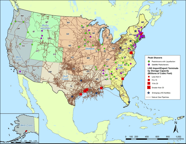 Figure 30. Map. U.S. liquefied natural gas facilities with natural gas pipeline network.
(Source: U.S. Energy Information Agency; Pipeline and Hazardous Materials Safety Administration, "Figure 3.6 U.S. LNG Facilities with Natural Gas Pipeline Network," Risk Assessment Study of Surface Transport of Liquid Natural Gas (LNG), 2018.) The third component of the PHMSA framework, LNG Transportation, describes how LNG is physically conveyed over the LNG Network. The vast majority of natural gas is moved by pipeline and when natural gas is moved by truck and vessel, it is assumed that it is moved in liquefied form. In their 2018 report, PHMSA reported that a preliminary analysis of the U.S. EIA. Survey 176 data, which is published as part of the U.S. EIA Annual Report, shows that roughly 65.1 million cubic feet (MMCF) of natural gas were moved across the U.S. in 2016—99.574 percent by pipeline, 0.421 percent by vessel, and 0.004 percent by truck. Figure 31 shows movements of natural gas that are captured by the EIA Survey 176. Net Interstate movements, imports, and exports of natural gas are represented by the mode of transportation: pipeline, truck, and vessel. Imports and exports are shown in red, while domestic movements are shown in blue. These movements are the net result of movements that may occur in either directions, showing the dominating direction of flow. Though pipelines are the most efficient for moving natural gas over short distances, truck movements of natural gas in its liquefied form do occur with truck transport being the main alternative to pipeline delivery. Figure 32 shows gross Interstate movements of LNG by truck. A single truck carries 10,943 gallons of LNG, which is equivalent to 0.9 million cubic feet of natural gas. Therefore, the movement of one million cubic feet of natural gas between Texas and Delaware can be estimated to represent one truck. 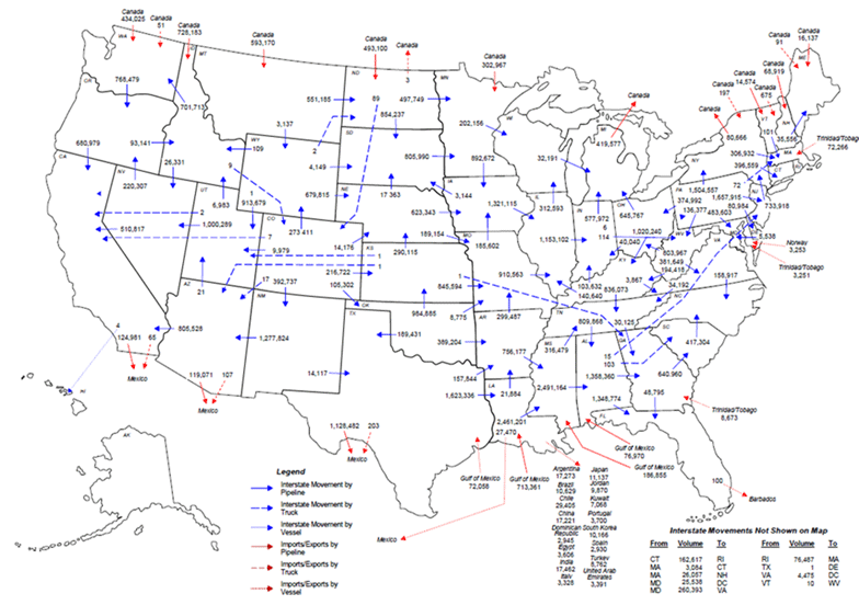 Figure 31. Map. Net interstate natural gas movements.
(Source: U.S. Energy Information Agency, "2016 Annual Report"; Pipeline and Hazardous Materials Safety Administration, "Figure 3.13 Net Interstate Natural Gas Movements 2016 Annual Report," Risk Assessment Study of Surface Transport of Liquid Natural Gas (LNG), 2018.) 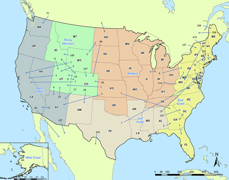 Figure 32. Map. Gross interstate natural gas movements by truck in 2016.
(Source: U.S. Energy Information Agency, "2016 Annual Report"; Pipeline and Hazardous Materials Safety Administration, "Figure 3.14 Gross Interstate Natural Gas Movements by Truck in 2016," Risk Assessment Study of Surface Transport of Liquid Natural Gas (LNG), 2018.) Figure 33 and figure 34 give additional perspective on truck movements by showing gross LNG movements and the truck movements solely between production and consumption natural gas regions, respectively. In particular, figure 34 illustrates that the majority of the movements are within the natural gas regions, but some of the LNG movements do move more than 1,000 miles. Observing current movements of LNG by truck reveals how the market handled the inability of the pipeline network to serve certain consumer demands. This provides insight on the origins that have liquefied LNG supply and the destinations that demand natural gas from off the pipeline grid. 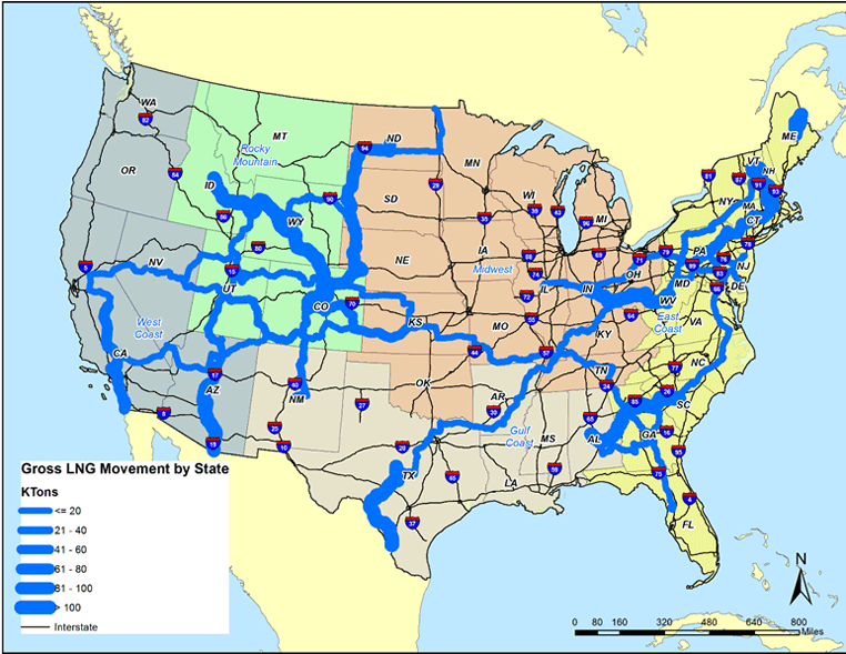 Figure 33. Map. Gross liquefied natural gas movements by State (truck, 2016).
(Source: U.S. Energy Information Agency, "2016 Annual Report"; Pipeline and Hazardous Materials Safety Administration, "Figure 3.16 Gross Interstate Natural Gas Movements by State—Truck, 2016," Risk Assessment Study of Surface Transport of Liquid Natural Gas (LNG), 2018.)  Figure 34. Map. Liquefied natural gas truck movements between regions in 2016.
(Source: U.S. Energy Information Agency, "2016 Annual Report"; Pipeline and Hazardous Materials Safety Administration, "Figure 3.17 LNG Truck Movements between Regions in 2016," Risk Assessment Study of Surface Transport of Liquid Natural Gas (LNG), 2018.) The final component of the PHMSA LNG framework is LNG Economics. The price of natural gas and the cost of transportation play a large role in where it is sourced. LNG competes with other fuel sources (such as pipeline gas, propane, and diesel) and is sourced when it is cost-competitive with those alternatives. In the case of pipeline gas, LNG is typically cost-competitive when a region does not contain an extensive pipeline network or the network is oriented in the opposite direction of travel than what is needed (i.e., the network was designed to supply gas to other areas as opposed to receiving gas). If another fuel source were more economical to procure, the users could switch products. As long as a supply source is close enough that the cost to transport it and supply it is cheaper than other energy products, the LNG will move. In conjunction with the other components of the PHMSA LNG framework, the LNG Economic component is used to develop alternative scenarios by which LNG will be demanded by certain regions, supplied by others, and transported over the LNG network. Main TakeawaysAs its name implies, the PHMSA LNG Commodity Flow Framework focuses on the movement of a specific type of natural gas—LNG. While the vast majority of natural gas is moved by pipeline, a small percentage is moved by truck and vessel in liquefied form. PHMSA estimated that the breakdown of natural gas movement by mode is 99.574 percent by pipeline, 0.421 percent by vessel, and 0.004 percent by truck. The differences in how natural gas may be transported domestically based on its form (i.e., liquid, compressed, or gas) do not appear to be explicitly considered in the FAF4 OOS methodology. The framework developed by PHMSA offers some insights for better incorporating those into the FAF4. However, as the PHMSA estimates indicate, this is a small portion of overall flows. Summary of Alternative Commodity Flow Survey Out-of-Scope MethodsThe literature search for alternative methodologies for estimating CFS out-of-scope commodity movements revealed that there are relatively few efforts on which to draw comparisons. The most applicable efforts were those conducted as part of the National Cooperative Freight Research Program and the University of Texas at Austin (UT Austin) Center for Transportation Research (CTR). These efforts estimated movements of farm-based shipments, municipal solid waste, and timber, among others. Both the NCFRP Report 26 and the UT Austin CTR methodologies can be viewed as supply chain-based processes for modeling commodity flows. Both methods relied on knowledge of commodity supply chains gathered from industry trade groups or academic literature. While the NCFRP Report 26 employed an origin-destination survey, the UT Austin CTR methodology primarily relied on third-party data sources. Both methodologies demonstrated how data collected at the local level and knowledge of commodity supply chains can be used to augment national data sources for the purpose of developing sub-national commodity flows. The challenge with applying these methodologies at the national scale are the number of distinct farm-based commodities. There are 117 farm-based commodities included in the FAF4. Applying the NCFRP and UT Austin CTR methodologies of augmenting national data with local and supply chain data would require that the process be extended to all 117 of these commodities. Thus, recreating this type of analysis at the national level for all farm-based commodities would require an extensive new data collection given the vast number of crops that are included in farm-based shipments. While this may be a worthwhile effort over the long-term, a more feasible short-term alternative would be to apply a similar supply chain-based methodology to a smaller number of farm-based commodities that are large in magnitude relative to the scale of OOS flows, or that are deemed economically important from a national perspective. The literature review revealed additional insight into the distribution patterns of freshly harvested logs. The results of the research conducted by the UT Austin CTR and the National Center for Freight and Infrastructure Research and Education (CFIRE) implied that though logging shipments from timber-producing sites are primarily local, in many cases they are not limited to FAF4 zones that end at State borders. In the case of timber producing regions such as Upper Peninsula of Michigan/North Wisconsin, southeastern Texas and western Louisiana and Arkansas, and South Georgia/North Florida, logging shipments may cross State lines into neighboring FAF4 zones to access processing facilities and/or rail spurs. Though the magnitude of these movements relative to other OOS commodity flows is relatively small as indicated by table 10 in chapter 2, they are important for State and regional partner-agencies that utilize the FAF4 for statewide and regional freight planning. (Source: Federal Highway Administration.)52 Transportation Research Board, NCFRP Report 26: Guidebook for Developing Subnational Commodity Flow Data, National Cooperative Freight Research Program, 2013. [Return to footnote 52] 53 Fuller, S., The Texas Grain Transportation Study, 2011. [Return to footnote 53] 54 Bureau of Transportation Statistics (BTS), "2017 Commodity Flow Survey Overview and Methodology," Accessed February 5, 2019. [Return to footnote 54] 55 Lautala, P., Pouryousef, H., Stewart, R., Ogard, L., Vartiainen, 2012. "Analyzing Log and Chip Truck Performance in the Upper Peninsula of Michigan withGPS Tracking Devices," National Center for Freight and Infrastructure Research and Education, University of Wisconsin—Superior. [Return to footnote 55] 56 New York Metropolitan Transportation Council, NYMTC Regional Freight Plan Update 2015-2040 Interim Plan. [Return to footnote 56] 57 New York State Department of Environmental Conservation, Beyond Waste: A Sustainable Materials Management Strategy for New York State. [Return to footnote 57] 58Transportation Research Board, NCFRP Report 26: Guidebook for Developing Subnational Commodity Flow Data, National Cooperative Freight Research Program, 2013. [Return to footnote 58] You may need the Adobe® Reader® to view the PDFs on this page. |
|
United States Department of Transportation - Federal Highway Administration |
||