Research, Development, and Application of Methods to Update Freight Analysis Framework Out-of-Scope Commodity Flow Data and Truck Payload FactorsChapter 2. Existing Freight Analysis Framework Version 4 Commodity Flow Survey Out-of-Scope MethodsThis chapter contains a review of the existing Freight Analysis Framework Version 4 (FAF4) methodologies for incorporating Commodity Flow Survey (CFS) out-of-scope (OOS) commodities. The Oak Ridge National Laboratory report The Freight Analysis Framework Version 4 (FAF4) Building the FAF4 Regional Database: Data Sources and Estimation Methodologies along with additional information provided by Federal Highway Administration (FHWA), is the foundation for the assessment. Each CFS OOS commodity receives its own, distinct analysis within the review. Farm-Based ShipmentsThis OOS category covers farm-based agricultural shipments from the field to grain elevator, distribution or processing center, or slaughterhouse. Under FAF4, truck is the assumed mode for transporting all farm-based agricultural shipments. DataFAF4 uses five (5) primary data sources to estimate flows of farm-based shipments:
The Census of Agriculture is a census conducted every five years by the USDA. It coincides with the Economic Census, which occurs in years ending in "2" and "7."3 The Census of Agriculture provides statistical information at the national, State, and county levels. All agricultural production establishments (e.g., farms, ranches, nurseries, greenhouses, etc.) are included in the census. The latest available data is from the 2012 Agriculture Census. The Agricultural Statistics is an annual publication prepared by the National Agricultural Statistics Service (NASS) of the USDA.4 It provides information on agricultural production, supplies, consumption, facilities, costs, and returns. The latest available data is published in Agricultural Statistics 2013 and contains preliminary estimates for 2012 and projections for 2013. The NASS also issues a series of Statistical Bulletins that contain final estimates for agricultural data series based on the review of the 2012 Census of Agriculture and other information.5 Farm-based commodity flows are also estimated using information from the Vehicle Inventory and Use Survey (VIUS) conducted as part of the Economic Census.6 The VIUS collects information on the physical and operational characteristics of the private and commercial truck population in the U.S. However, this survey program was discontinued prior to the 2007 Economic Census making the 2002 VIUS the latest available data in this series. Lastly, farm-based commodity flows are also estimated using information from published statistics from the Commodity Flow Survey (CFS) which produces data on the movement of goods by their Standard Classification of Transported Goods (SCTG) commodity code.7 Tonnage and value by origin information from the 2012 CFS for shipments of live animals and fish (SCTG 01); cereal grains including seeds (SCTG 02); agricultural products except for animal feed, cereal grains, and forage products (SCTG 03); animal feed, eggs, honey, and other products of animal origin (SCTG 04); meat, poultry, fish, seafood, and their preparations (SCTG 05); other prepared foodstuffs, fats and oils (SCTG 07); and tobacco products (SCTG 09). MethodologyAs shown in figure 1, generally the methodology for estimating farm-based commodity flows involves: (1) estimating agricultural production at the statewide level, (2) estimating agricultural production at the Freight Analysis Framework (FAF) zone level, and (3) estimate the origin-destination flows of farm-based shipments.8 This section of the technical memorandum describes in detail the estimation process for farm-based shipments. 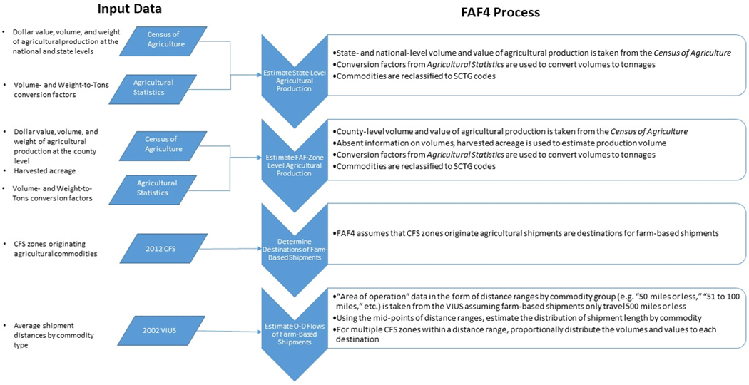 Figure 1. Flowchart. Methodology for farm-based shipments.
(Source: Oak Ridge National Laboratory, The Freight Analysis Framework Version 4 (FAF4) Building the FAF4 Regional Database: Data Sources and Estimation Methodologies, September 2016.) Estimate Agricultural Production at the Statewide LevelEstimating agricultural production at the statewide level begins with obtaining the dollar value of agricultural production at the national and State levels from the Census of Agriculture.9 Specifically, as shown in figure 2 FAF4 uses "Table 2. Market Value of Agricultural Products Sold Including Direct Sales: 2012 and 2007" of the Agriculture Census to estimate State and national-level agricultural production. The FAF4 then estimates the tonnages associated with the production of agricultural commodities. Though the Agriculture Census estimates the volumes and/or weights of agricultural production at the national and State levels, different units of measurements are used across commodities as shown in figure 3. For example, wheat is measured in bushels, cotton is measured in bales, rice is measured in hundredweight, and so on. In order to convert the production by volume or weight into tonnages, FAF4 utilizes conversion factors found in Agricultural Statistics 2013 (see figure 4).10 The FAF4 then reclassifies the USDA commodity groupings from the Agricultural Census into SCTG codes in order to be consistent with all other FAF4 commodity flows (see appendix A). 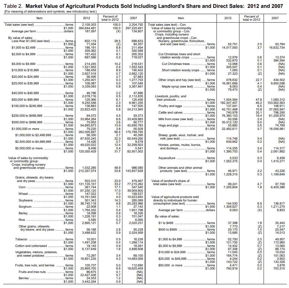 Figure 2. Sample chart. Market value of agricultural products sold including direct sales: 2012 and 2007. Figure 2. Sample chart. Market value of agricultural products sold including direct sales: 2012 and 2007.(Source: U.S. Department of Agriculture, Agriculture Census, 2012. Table 2. Market Value of Agricultural Products Sold Including Direct Sales: 2012 and 2007.) 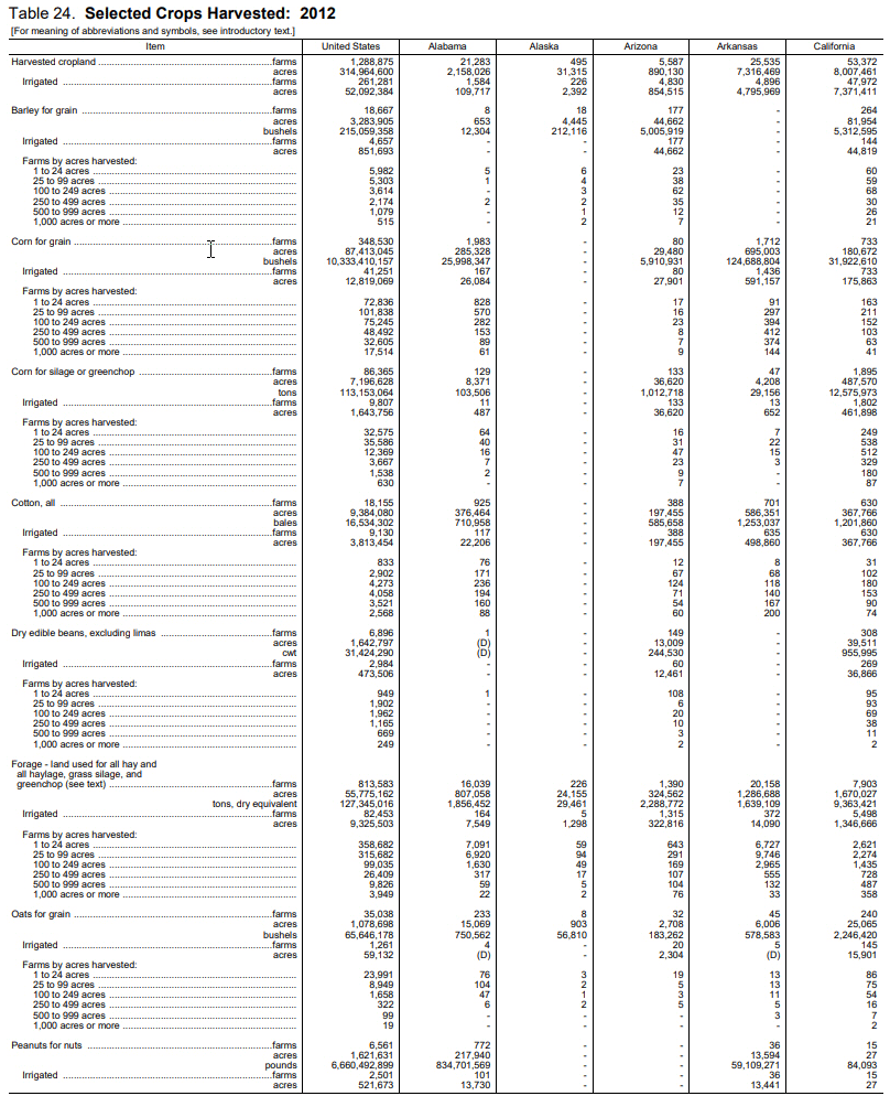 Figure 3. Sample chart. Selected crops harvested: 2012.
(Source: U.S. Department of Agriculture, "Table 24. Selected Crops Harvested: 2012," Chapter 2: State Level Data, Census of Agriculture, Volume 1.) 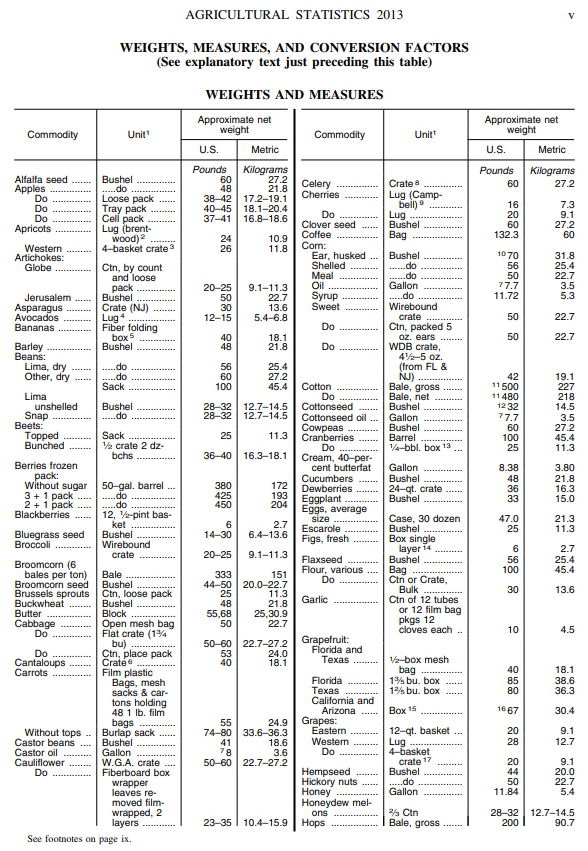 Figure 4. Sample chart. Conversion factors.
(Source: U.S. Department of Agriculture, Agricultural Statistics, 2013.) Disaggregate Agricultural Production from the State-level to the Freight Analysis Framework Zone-LevelAgricultural production at the FAF zone level is estimated using a procedure similar to the one implemented at the State level. The 2013 Agricultural Census has similar information on agricultural production by value and weight and/or volume at the county level (see figure 5 for an example using data from the State of Georgia). County-level estimates are aggregated to FAF zone levels for those States that are divided into multiple FAF zones. For commodities for which production weight or volume data is not provided, FAF4 uses the amount of harvested acreage to estimate total tonnage. The FAF4 does this by distributing the State-level totals to counties in proportion to their share of State-level harvested acreage. 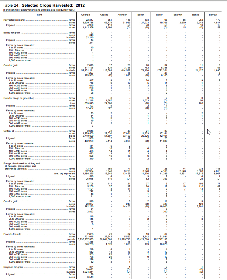 Figure 5. Sample chart. Selected crops harvested: 2012—State of Georgia example.
(Source: U.S. Department of Agriculture, "Table 24. Selected Crops Harvested: 2012," Chapter 2: County Data, Georgia: State and County Data, Census of Agriculture, Vol. 1, Geographic Area Series, Part 10, AC-12-A-10.) Estimate Origin-Destination Flows of Farm-Based ShipmentsThe FAF4 uses VIUS 2002 data to estimate the distribution of average shipment distances using information on the typical "area of operation" for trucks carrying agricultural products. The VIUS reports areas of operation as: off-the-road; 50 miles or less; 51 to 100 miles; 101 to 200 miles; 201 to 500 miles; 501 miles or more; not reported; and not applicable (i.e., vehicle not in use). The FAF4 assumes that farm-based shipment activity is largely local, thus the "501 miles or more" category is not included in the estimation process. In addition, the FAF4 only considers CFS areas that shipped out products associated with the farm-based commodity as eligible destinations for the commodity flow. For example, CFS areas with shipments of "tobacco products" that originated from their locations were considered as potential destinations for "tobacco harvested" from a farm. Using the mid-points of the remaining range categories and the distribution of operating ranges for agricultural products, the FAF4 develops a distribution of shipment lengths for each of the corresponding SCTG commodity-carrying truck groups by State. When multiple FAF4 regions are within the same distance range from a given "production" area (i.e., FAF4 origin of the farm-based shipment), the estimated shipment total is divided proportionally among all involved destination FAF4 regions. This method is applied to both values and tonnages of farm-based shipments. ResultsThe FAF4 estimates that farm-based agricultural shipments accounted for nearly 1 billion tons of commodity flows at the national level as shown in table 1. This amounts to nearly $385.4 billion in value. Furthermore, farm-based agricultural shipments account for more than 5.6 percent of all commodity movements by weight at the national level.11 Thus, any improvement to the methodology for estimating farm-based agricultural shipments or the data that support its estimation will result in a substantial impact to the estimate for total agricultural shipments.
(Source: Oak Ridge National Laboratory, "Table 5-1. National Total for Farm-Based Agricultural Shipments in 2012," The Freight Analysis Framework Version 4 (FAF4)—Building the FAF4 Regional Database: Data Sources and Estimation Methodologies, September 2016.)
FisheriesOut-of-scope fishery shipments are those that occurred prior to the first point of processing or before arriving to the distribution center. Once shipments reach those points, they become in-scope and are covered under the commodity flow survey. Fishery shipments fall under commodity code SCTG 01. DataThe primary data source for OOS fishery shipments is the Fisheries of the United States report published annually by the National Marine Fisheries Service (NMFS) of the National Oceanic and Atmospheric Administration (NOAA) and also from data series published by the NMFS on which the report is based (such as landings at major U.S. ports).12, 13, 14 It contains statistics on the value and tonnage of fishery landings with landings from U.S. territorial seas, the U.S. Exclusive Economic Zone, and on the high seas. The information in the report comes from NMFS field offices with cooperation from coastal States. Statistics on U.S. commercial landings are available for major U.S. ports (see figure 6), regions (i.e., New England, Middle Atlantic, Chesapeake, South Atlantic, Gulf, Pacific Coast, Great Lakes, and Hawaii), and States. 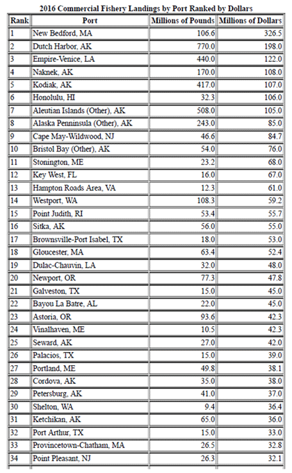 Figure 6. Sample chart. Example of commercial fishery landings at major U.S. ports.
(Source: National Marine Fisheries Service, National Oceanic and Atmospheric Administration.) MethodologyAs shown in figure 7, the FAF4 estimation process uses the State-level statistics on tonnage and value from the Fisheries of the United States report to estimate production at the State level.15 NMFS data on fishery landings at the top 104 ports by value are then used to disaggregate production data to FAF4 zones. Lastly, origin-destination flows of fishery is estimated, assuming that all shipments occur within the FAF4 zone in which the port is located. The remainder of this section describes in detail the specific steps involved in the estimation of fishery shipments. 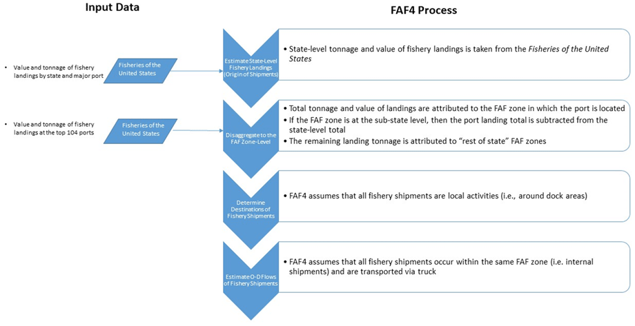 Figure 7. Flowchart. Methodology for fishery shipments.
(Source: Oak Ridge National Laboratory, The Freight Analysis Framework Version 4 (FAF4) Building the FAF4 Regional Database: Data Sources and Estimation Methodologies, September 2016.) Estimate State-Level Fishery LandingsThe FAF4 uses the State-level statistics on tonnage and value from the Fisheries of the United States report to estimate production at the State level. According to these data, commercial fishery landings totaled approximately 4.8 million tons and were valued at over $5.1 billion in 2012. Disaggregate Fishery Landings from the State- to the Freight Analysis Framework Zone-LevelNational Marine Fisheries Service data on fishery landings at the top 104 ports by value are used to disaggregate production data to FAF4 zones. The total tonnage and value of landings are attributed to the FAF4 zone in which the port is located. If the FAF4 zone is at the sub-State level, then the port landing total is subtracted from the State-level total and that residual amount is allocated to the "rest of State" zones. Estimate Origin-Destination Flows of Fishery ShipmentsUnder FAF4, fishery shipments are assumed to be local activities (i.e., around dock areas). Thus, shipments are assumed to be within the same FAF4 zone. Furthermore, all fishery movements are assumed to occur by truck. ResultsConsistent with the Fisheries of the United States report, the FAF4 estimates approximately 4.8 million tons of fishery shipments valued at over $5.1 billion in 2012. Though the Oak Ridge National Laboratory (ORNL) report does not specify to which commodity code fishery shipments are assigned, most likely it is SCTG 01 (Live animals/fish). In 2012, SCTG 01 commodity flows accounted for over 100 million tons valued at over $1.66 billion. This implies that fishery shipments comprise under 5 percent of SCTG 01 flows by weight and about 3 percent by value. For all commodity flows, fishery shipments represent less than 0.03 percent by weight and value. Thus, an improvement in the methods or data supporting the estimation of this OOS commodity is not likely to result in a substantial impact for the broader commodity group or at the national level. However, as articulated in the Oak Ridge National Laboratory report The Freight Analysis Framework Version 4 (FAF4) Building the FAF4 Regional Database: Data Sources and Estimation Methodologies, though fishery shipments are small at the national level they are substantial in weight in value for States with major commercial fishing industries such as Alaska. LoggingIn the FAF4, logging industry shipments fall within commodity code SCTG 25. This covers shipments from field (forests) to processing facilities (timber cutting and/or transporting). DataFAF4 uses three (3) primary data sources for estimating Logging OOS commodity flows:
The FIDO is an online tool maintained by the USDA Forest Service under the Forest Inventory and Analysis (FIA) National Program.17 It is managed by the USDA Forest Service's Research and Development office. The FIA is actually comprised of multiple tools for inventorying and monitoring forests and grasslands and estimating changes in forest land over space and time. The FAF4 collects from the FIDO the quantity of harvest removals (in board feet) by location and species type to determine the weight of the logs heading to process facilities. TPO Reports are also produced by the USDA Forest Service.18 For the States of California and Nevada, specifically, the TPO Reports are used to obtain the quantity of soft and hard wood from the published "2012 State Level Core Tables." 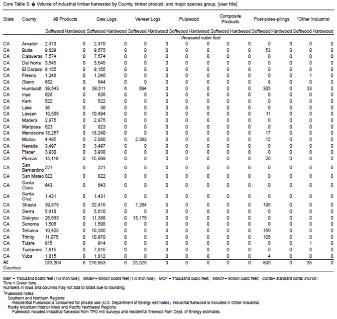 Figure 8. Sample chart. Core Table 5: Volume of industrial timber harvested by county, timber product, and major species group—California.
(Source: USDA Forest Service.) The FAF4 uses information on prices of soft and hard woods provided in various State or Region Price Reports to determine the value and tonnage of Logging OOS commodities. Example reports include the Timber Mart, Bureau of Business and Economic Research at the University of Montana, and the Texas Forest Service's Stumpage Prices Trends.
(Source: Pennsylvania State University, College of Agricultural Sciences, Penn State Extension, Timber Market Report: 2018 2nd Quarter.)
MethodologyAs shown in figure 9, the FAF4 estimation process first develops State and county totals of board feet produced using statistics published in the FIDO and TPO reports.19 The FAF4 then estimates the value of Logging OOS commodities using information from the State and region price reports. After that, county-level estimates of tonnage and value produced are aggregated to the FAF4 zone level. Finally, origin-destination flows are estimated assuming that logging shipments are internal to the FAF4 zone in which the timber-producing site is located. The remainder of this section describes in detail the specific steps involved in the estimation of logging commodity flows. 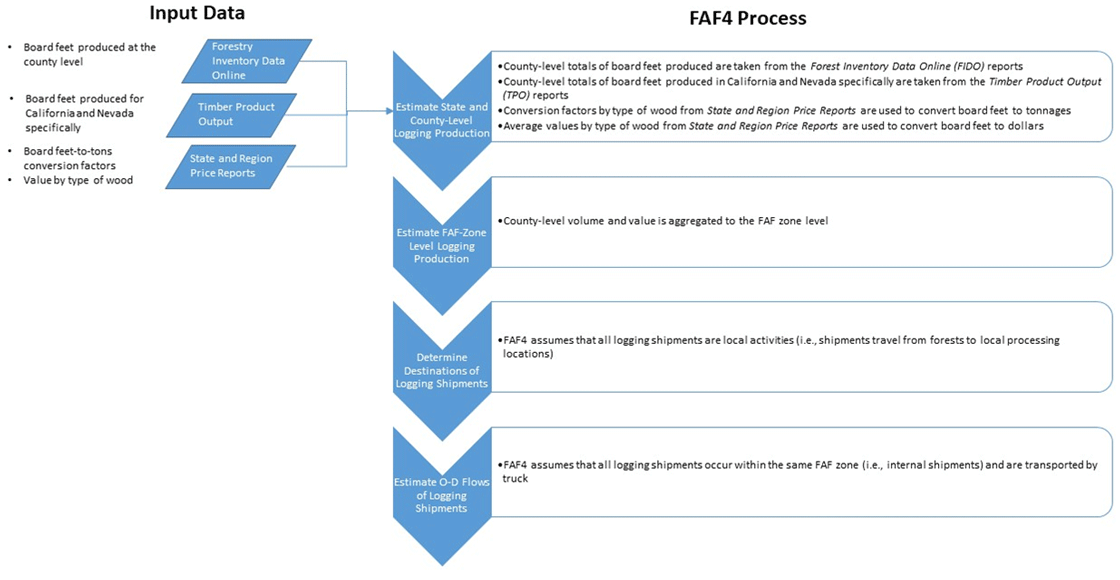 Figure 9. Flowchart. Methodology for logging shipments.
(Source: Oak Ridge National Laboratory, The Freight Analysis Framework Version 4 (FAF4) Building the FAF4 Regional Database: Data Sources and Estimation Methodologies, September 2016.) Estimate County-Level Logging ProductionThe FAF4 first estimates State and county totals of board feet produced using statistics published in the FIDO and TPO reports. The FIDO contains the amount of board feet produced at the county level. These county level totals of board feet are converted to tonnage based on the location and type of wood—softwood or hardwood—using information from the State and Region Price Reports. Information from these reports are used to account for the fact that the weight of softwoods and hardwoods can vary across the U.S. The FAF4 then estimates the value of Logging OOS commodities using information from the State and region price reports. Like weight, the reports are used to account for variations in price across the U.S. Aggregate County-Level Logging Production to the Freight Analysis Framework Zone-LevelCounty-level estimates of tonnage and value produced are then aggregated to the FAF4 zone level. Estimate Origin-Destination Flows of Logging ShipmentsUnder FAF4, the movement of OOS logging shipments is assumed to occur only at the local level (i.e., shipments travel from forests to local processing locations). Thus, OOS logging shipments are estimated to consist solely of intra-zone movements. Furthermore, the FAF4 assumes that all OOS logging shipments occur by truck.20 This assumption is supported with the observation from the Waybill Carload Sample data that only about 2 million tons of rail shipments fall under this commodity category, which is less than 1 percent of the estimated total shipment tonnage. ResultsThe FAF4 estimates 239 million tons of OOS logging shipment activity worth over $6.4 billion in 2012.21 In 2012, SCTG 25 commodity flows accounted for over 297 million tons valued at over $13 billion. This implies that OOS logging shipments comprise over 80 percent of SCTG 25 flows by weight and nearly 50 percent by value. For all commodity flows, OOS logging shipments represent just over 1 percent by weight and less than 1 percent by value. Municipal Solid Waste and Construction and Demolition DebrisMunicipal Solid WasteMunicipal solid waste (MSW) products are collected from homes, schools, hospitals, and businesses and includes:
MSW products are disposed in landfills and are also processed in incinerators and resource recovery facilities. DataData for estimating MSW flows primarily comes from three sources:
Several States produce annual reports on their solid waste management facilities and activities. Typically, these reports are produced by their environmental and/or health departments and include information on the volume of waste and recycling generation, import and export of waste across State borders, and allocation of waste to landfills at the county and State levels. A total of 34 State reports were used in the FAF4. 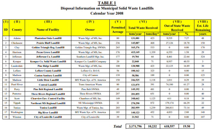 Figure 10. Sample chart. Disposal information on municipal solid waste landfills in Mississippi. Figure 10. Sample chart. Disposal information on municipal solid waste landfills in Mississippi.(Source: Oak Ridge National Laboratory, The Freight Analysis Framework Version 4 (FAF4) Building the FAF4 Regional Database: Data Sources and Estimation Methodologies, September 2016.) Because not every State provides annual reports on solid waste activities, the FAF4 also uses data from the State of Garbage in America Survey. This survey was conducted by the Earth Engineering Center of Columbia University and the BioCycle Journal on a bi-annual basis from 2002 to 2010. The survey was not conducted in 2012 and the 2013 effort was led solely by Columbia University. The survey is administered to the waste management agencies in all 50 States on the topics of the generation and disposition of MSW. There are two primary objectives to the survey: (1) compile and analyze waste management data provided by State waste management agencies; and (2) resolve the large data discrepancy between landfilling data provided by State waste management agencies and the U.S. EPA reports on MSW Facts and Figures.  Figure 11. Example survey. BioCycle state of garbage survey.
(Source: Oak Ridge National Laboratory, The Freight Analysis Framework Version 4 (FAF4) Building the FAF4 Regional Database: Data Sources and Estimation Methodologies, September 2016.) The FAF4 also uses data from the Advancing Sustainable Materials Management: Fact Sheet (formerly known as Municipal Solid Waste in the United States: Facts and Figures) produced annually by the U.S.EPA. The Fact Sheet contains annual estimates on MSW generated and disposed at the national level. The 2014 and 2015 versions were expanded to include construction and demolition debris.  Figure 12. Sample chart. Example of municipal solid waste data from the Advancing Sustainable Materials Management: Fact Sheet.
(Source: U.S.EPA.) MethodologyAs shown in figure 13, the FAF4 first uses the State Annual Reports to produce MSW tonnages at the county and State levels.23 For States that do not publish annual reports, the FAF4 uses data from the BioCycle survey. The FAF4 aggregates the MSW tonnages to the FAF4 zone level for States with county-level estimates of MSW production. For States that do not have county-level data, the FAF4 disaggregates MSW production to the FAF4 zone level using population shares. Lastly, the FAF4 develops the origin-destination MSW flows using information from the State Annual Reports and assumptions on local movements of MSW shipments. Greater details on the MSW estimation process are included in the remainder of this section. 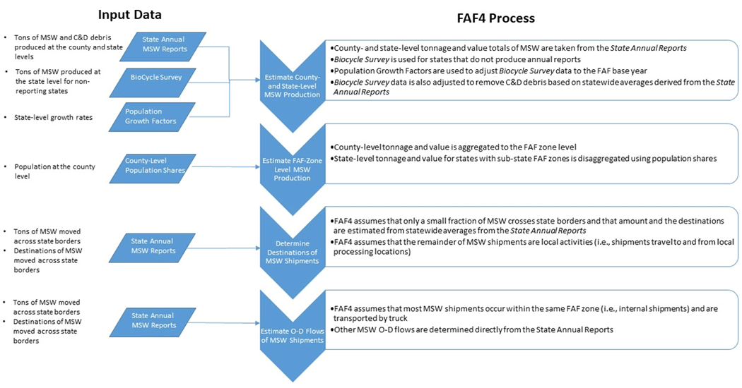 Figure 13. Flow chart. Methodology for municipal solid waste shipments.
(Source: Oak Ridge National Laboratory, The Freight Analysis Framework Version 4 (FAF4) Building the FAF4 Regional Database: Data Sources and Estimation Methodologies, September 2016.) Estimate County- and State-Level Municipal Solid Waste ProductionThe FAF4 uses the State Annual Reports to produce MSW tonnages at the county and State levels. For States that do not publish annual reports, the FAF4 uses data from the BioCycle survey. Using 2011 data, population growth factors were applied to estimate 2012 MSW production levels. Because BioCycle data includes construction and demolition (C&D) debris with its MSW estimates, the FAF4 estimates the amount of C&D debris and removes this from the State-level estimates in order to avoid double-counting. Based on State-provided C&D debris data, the FAF4 estimates that on average C&D debris account for about 23 percent of BioCycle-reported State-level numbers. Using this factor, the FAF4 adjusts the BioCycle-based estimates to remove the C&D portion of MSW volumes. In total, the FAF4 estimated that 309 million tons of MSW was produced and subsequently landfilled and recycled. Furthermore, the FAF4 methodology assumes that as a commodity, MSW has no value. Estimate Freight Analysis Framework Zone-Level Municipal Solid Waste ProductionFor States with county-level estimates of MSW production, those values are aggregated to the FAF4 zone level. For States that do not have county-level data, the FAF4 disaggregates MSW production to the FAF4 zone level using population shares. Estimate Origin-Destination Flows of Municipal Solid Waste ShipmentsMSW is sometimes moved between landfills across State borders. The FAF4 uses the State Annual Reports to determine the Origin-Destination (O-D) and associated tonnage of MSW being moved. Overall, the FAF4 estimates that the amount of MSW moved across State borders is relatively small—about 7 percent. The remainder of MSW movements are assumed to occur within States as internal movements. ResultsThe FAF4 estimated that about 309 million tons of MSW was moved in 2012. About 23 million tons were estimated to move by truck across State borders. Construction and Demolition DebrisDebris from construction and demolition activities is one of the largest components of the U.S. solid waste stream. C&D shipments originate from the construction of residential and nonresidential buildings, utility systems, roadways and bridges, among others. These types of shipments generally consist of bulky heavy material, such as concrete, wood, metals, glass, and salvaged building components. Though the majority of C&D debris is recycled, the statistical tracking of tonnage has been limited. DataThe FAF4 uses similar data sources for C&D debris flows as used for MSW flows:
State-produced annual reports on solid waste management facilities and activities also sometimes contain information on C&D debris. However, among the reporting States few actually produce this information. Because not every State provides annual reports on solid waste activities and because even fewer provide information in these reports on C&D activities, the FAF4 also uses data from the State of Garbage in America Survey to supplement these reports. In 2014, the Department of Environmental Engineering at the University of Florida produced a white paper for the Construction and Demolition Recycling Association titled The Benefits of Construction and Demolition Materials Recycling in the United States. Using industry data from the literature and industry surveys, the white paper estimated the amount of C&D debris generated in the United States. For 2012, the analysis year used by FAF4, the white paper estimated that approximately 480 million tons of C&D debris was generated. It also estimated that over 70 percent of C&D debris was recovered and recycled in 2012. The breakdown of the components in the C&D debris stream is as follows:
MethodologyAs shown in figure 14, the FAF4 first uses the State Annual Reports to produce C&D tonnages at the county and State levels.25 For States that do not publish annual reports, the FAF4 uses data from the BioCycle survey. The FAF4 then aggregates the C&D tonnages to the FAF4 zone level for States with county-level estimates. For States that do not have county-level data, the FAF4 disaggregates C&D production to the FAF4 zone level using population shares. Lastly, the FAF4 develops the origin-destination C&D flows using information from the State Annual Reports and assumptions on local movements of C&D shipments. Greater details on the C&D estimation process are included in the remainder of this section. 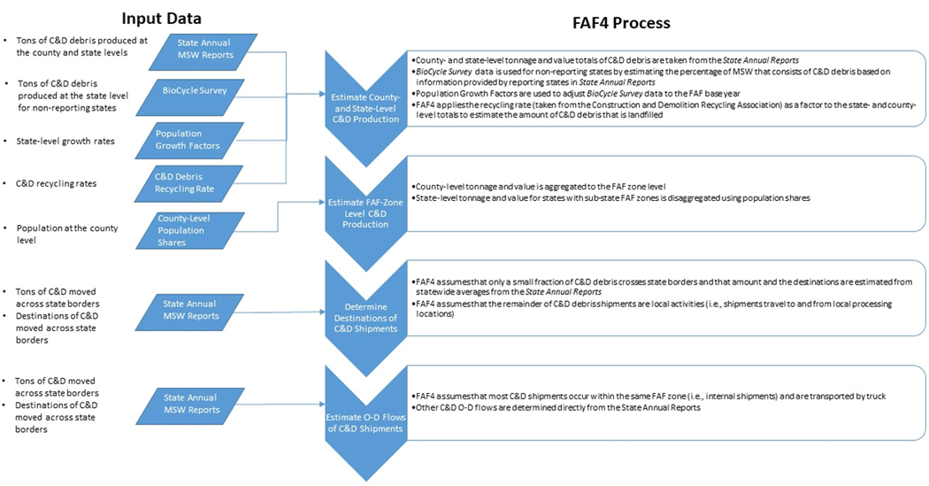 Figure 14. Flow chart. Methodology for construction and demolition shipments.
(Source: Oak Ridge National Laboratory, The Freight Analysis Framework Version 4 (FAF4) Building the FAF4 Regional Database: Data Sources and Estimation Methodologies, September 2016.) Estimate County- and State-Level Construction and Demolition ProductionAs discussed in the section on Municipal Solid Waste, from the State annual reports the FAF4 estimates that approximately 23 percent of reported MSW flows consist of C&D debris. The FAF4 then applies that factor to the BioCycle-reported State and county totals for those States that do not provide annual reports. The CDRA white paper estimates that 70 percent of all C&D debris is recycled. The FAF4 applies this factor to individual State totals of C&D debris to estimate how much is landfilled and the amount that is recycled. It is noted that both the CDRA and BioCycle estimate State-level totals which are inconsistent with each other (e.g., the CDRA reported 480 million total tons while BioCycle reported 448 million tons in 2012). The FAF4 assumes that BioCycle estimate is more accurate. Estimate Freight Analysis Framework Zone-Level Construction and Demolition ProductionFor States with county-level data on C&D debris flows, the FAF4 aggregates this information to the FAF4 zone level. Where county-level data is not available, the State-level tonnage is disaggregated to the FAF4 zone level using population shares calculated from the Census. The FAF4 uses population-based shares as opposed to economic-based shares (e.g., sales or employment data) because population-based shares are believed to better reflect the locations of demolition sites where C&D debris is actually generated. Estimate Origin-Destination Flows of Construction and Demolition ShipmentsFurthermore, the FAF4 assumes that the majority of C&D debris flows occur within FAF4 zones. State annual reports are used to estimate the amount of C&D debris flows that move across State borders as well as their origins and destinations. ResultsConsistent with the BioCycle reported total, the FAF4 estimates 448 million tons of C&D shipment activity in 2012. RetailRetail shipments are those shipments that originate or terminate at a retail establishment. DataThere are three main sources of data for retail OOS commodity movements:
The Annual Retail Trade Survey, published by the U.S. Bureau of Census in the table "U.S. Retail Trade Sales—Total and E-commerce: 2013-1998," is one of the primary data sources for estimating retail sector commodity flows. The FAF4 used the "2012 revised" sales estimates by 3-digit North American Industry Classification System (NAICS) code as national control totals for industries associated with the retail sector. The 2012 total retail trade sales were estimated at $4.306 trillion including $229 billion from e-commerce. Economic Census Receipts are another primary source of data for retail OOS commodity flows. The Census publishes State-level data on sales receipts based on information collected in the 2012 Economic Census.27 The Census defines receipts as the operating revenue for goods produced or distributed, or for services provided excluding taxes collected. The Economic Census is conducted every five years in years ending with "2" or "7." The 2012 Economic Census estimated a total of $4.238 trillion in receipts was generated from the retail sector (NAICS 44-45). Receipt data at the 3-digit NAICS level is released only for 26 States and for most of the retail sectors in Washington D.C. For all other States, receipt data is published at the 2-digit NAICS (44-45) level. The final main source of information for retail OOS commodity flows is the Census' County Business Patterns (CBP) data series.28 The CBP data includes information on number of establishments, total employment number, first quarter payroll, and total annual payroll for each county within the U.S. figure 15 shows examples of records extracted from the Complete County File of CBP 2012. As shown in figure 15, CBP data is provided at various NAICS levels. Employment payroll data from the CBP data series is used to distribute State-level estimates of retail shipments to the FAF regions. 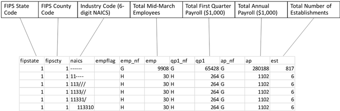 Figure 15. Sample chart. Example of county business patterns data.
(Source: U.S. Census Bureau, Federal Highway Administration.) MethodologyThough most goods purchased at retail establishments are carried home by their customers, the FAF4 assumes that some items will be delivered.29 As shown in figure 16, the FAF4 estimates the amount of retail sales that result in deliveries based on assumed shares according to the 3-digit NAICS industry code to which the retail establishment corresponds. Next, the FAF4 distributes the total State-level shipment values involved in each NAICS sector considered for retail OOS flows. After that, commodity-specific value-to-weight ratios are applied to derive estimates for shipment weights at the State level. The State-level estimates of values and weights are distributed to each FAF4 zone within the given State. Lastly, the origin-destination flows of retail shipments are estimated assuming that all retail flows are local (i.e., within a FAF4 zone). The remainder of this section provides more information on the steps involved in the estimation of retail commodity flows and the data they utilize. 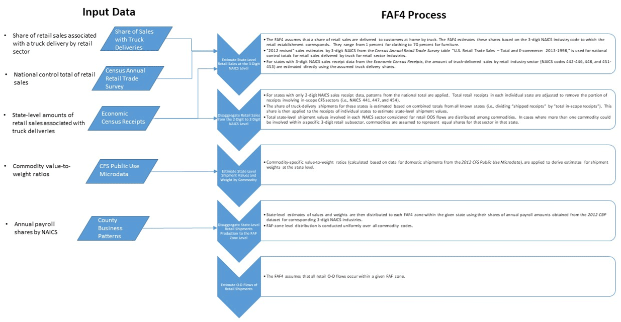 Figure 16. Flow chart. Methodology for retail shipments.
(Source: Oak Ridge National Laboratory, The Freight Analysis Framework Version 4 (FAF4) Building the FAF4 Regional Database: Data Sources and Estimation Methodologies, September 2016.) Estimate State-Level Retail Sales with Truck DeliveriesWhile it is assumed that most goods purchased at retail establishments are carried home by their customers, some items will be delivered via store-owned vans (or pick-up trucks) or delivered by mail or package carriers. Certain large items like appliances or furniture will be delivered by truck to the customer's home. Since data is lacking on actual shares of sales associated with truck deliveries, the FAF4 estimates these shares based on the 3-digit NAICS industry code to which the retail establishment corresponds. They range from 1 percent for clothing to 70 percent for furniture. As mentioned in the discussion of data used to estimate this commodity flow, the Census reports receipts data at the 3-digit NAICS code level for 26 States and Washington, D.C. and at the 2-digit level for all others. For the States with 3-digit NAICS sales receipt data, the total retail receipts associated with industry sectors involving truck deliveries (NAICS codes 442-446, 448, and 451-453) are estimated directly using the assumed shares. For all other States, patterns from the national total are applied. Specifically, total retail receipts in each individual State are reduced by 43 percent to remove the portion of receipts involving in-scope CFS sectors (i.e., NAICS 441, 447, and 454). The share of truck-delivery shipments for these States was assumed at 8.4 percent, as calculated based on combined totals from all known States (i.e., dividing "shipped receipts" by "total in-scope receipts"). This share was then applied to the receipts of individual States to estimate State-level shipment values. Disaggregate Total Retail Sales Shipped by States from the 2-Digit to the 3-Digit North American Industry Classification System LevelNext, the FAF4 distributes the total State-level shipment values involved in each NAICS sector considered for retail OOS flows. In cases where more than one commodity could be involved within a specific 3-digit retail subsector, commodities are assumed to represent equal shares for that sector in that State. Estimate State-Level Shipment Values and Weight by CommodityOnce the shipment values are separated by commodity code, commodity-specific value-to-weight ratios (as calculated based on data for domestic shipments from the 2012 CFS Public Use Microdata (PUM), are applied to derive estimates for shipment weights at the State level. Disaggregate State-Level Retail Shipment Production to the Freight Analysis Framework Zone LevelThe State-level estimates of values and weights are distributed to each FAF4 zone within the given State using their shares of annual payroll amounts obtained from the 2012 CBP dataset. The calculation of shares considered only payroll information associated with the corresponding 3-digit NAICS codes for retail. This FAF-zone level distribution is conducted uniformly over all commodity codes. Estimate Retail Shipment Origin-Destination FlowsSince most purchases at retail stores occur in regions where the customer resides, retail OOS commodity flows are assumed to be internal to the corresponding FAF4 zone. Furthermore, shipments in this OOS area are assumed to occur exclusively by truck. ResultsThe FAF4 estimated that a total of $206 billion, weighing 224 million tons, of CFS OOS retail goods were transported by truck in 2012. ServicesLike the retail sector, the FAF4 assumes that firms in service industry sectors generate freight shipments in the form of truck deliveries to customers. DataThere are three main sources of data for services OOS commodity movements:
The Service Annual Survey published by the U.S. Bureau of Census provides national estimates of annual revenues and expenses of establishments classified in select service industries. The estimates published by the Census are developed using a probability sample of firms in the United States that have paid employees. The 2012 Service Annual Survey data are summarized by industry classification based on the 2007 NAICS. From the 2012 Service Annual Survey, the FAF4 uses the "Estimated E-Commerce Revenue for Employer Firms: 1998 through 2012" table and supplements that information with other tables from the same report to generate estimates for the OOS Services sector. Information from the "Estimated E-Commerce Revenue for Employer Firms: 1998 through 2012" table is used to develop control totals at the national level for industries associated with the services sector by 3- to 5-digit NAICS codes as shown in table 3.
(Source: Oak Ridge National Laboratory, The Freight Analysis Framework Version 4 (FAF4) Building the FAF4 Regional Database: Data Sources and Estimation Methodologies, September 9, 2016 (Revised April 11, 2017).)
Economic Census Receipts are another primary source of data for OOS Services commodity flows. The Census publishes State-level data on sales receipts based on information collected in the 2012 Economic Census.31 The 2012 Economic Census estimated a total of $11.7 trillion in receipts was generated from the services sector (NAICS 51-81). Receipt data at the 3-digit NAICS level is released only for a limited number of States. The final main source of information for OOS Services commodity flows is the Census' County Business Patterns (CBP) data series.32 Employment payroll data from the CBP data series is used to distribute State-level estimates to the CFS areas. MethodologySimilar to the process for retail shipments, the FAF4 first estimates the amount of service sales that result in a shipment by truck as shown in figure 17.33 Next, the FAF4 distributes the total State-level shipment values involved in each NAICS sector considered for OOS Service flows among the relevant NAICS industries. The FAF4 then estimates the State-level shipment values and weights by commodity group. After that, the State-level estimates of values and weights are distributed to each FAF4 zone within the given State. Lastly, the FAF4 determines the O-D flows of the corresponding commodities. 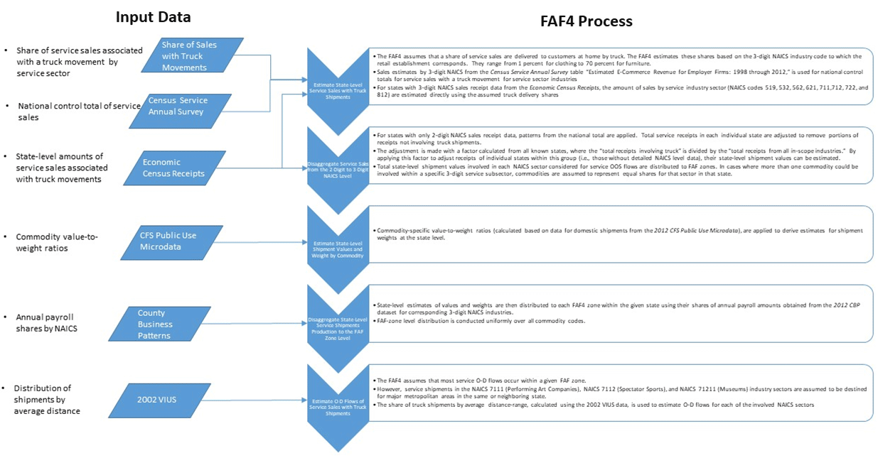 Figure 17. Flow chart. Methodology for service shipments.
(Source: Oak Ridge National Laboratory, The Freight Analysis Framework Version 4 (FAF4) Building the FAF4 Regional Database: Data Sources and Estimation Methodologies, September 2016.) Estimate State-Level Service Sales with Truck ShipmentsAs mentioned in the discussion of data for service commodity flows, the Census reports receipts data at the 3-digit NAICS code level for a limited number of States and at the 2-digit level for all others. For the States with 3-digit NAICS receipt data, the total receipts associated with relevant service industry sectors (identified in table 3) are estimated directly using assumed shares of truck shipments as was done for the retail sector. Data from the table "Estimated E-Commerce Revenue for Employer Firms: 1998 through 2012" in the Census Service Annual Survey is used in this step. Disaggregate Service Sales from the 2-Digit to the 3-Digit North American Industry Classification System LevelFor all other States, patterns from the national total are applied. In addition, total service receipts in each individual State are adjusted to remove the portion of receipts involving NAICS not involving truck deliveries. This adjustment was made with a factor calculated from all known States, where the "total receipts involving truck" is divided by the "total receipts from all in-scope industries." By applying this factor to adjust receipts of individual States within this group (i.e., those without detailed NAICS level data), their State-level shipment values can be estimated. Next, the FAF4 distributes the total State-level shipment values involved in each NAICS sector considered for OOS Service flows. In cases where more than one commodity could be involved within a specific 3-digit service subsector, commodities are assumed to represent equal shares for that sector in that State. Estimate State-Level Shipment Values and Weight by CommodityOnce the shipment values are separated by commodity code, commodity-specific value-to-weight ratios as calculated based on data for domestic shipments from the 2012 CFS PUM, are applied to derive estimates for shipment weights at the State level. Disaggregate State-Level Service Shipments Production to the Freight Analysis Framework Zone LevelAfter that, the State-level estimates of values and weights are distributed to each FAF4 zone within the given State using their shares of annual payroll amounts obtained from the 2012 CBP dataset. The calculation of shares considered only payroll information associated with the corresponding 3-digit NAICS codes for services. This FAF-zone level distribution is conducted uniformly over all commodity codes. Estimate Origin-Destination Flows of Service Sales with Truck ShipmentsLastly, the FAF4 determines the O-D flows of the corresponding commodities. For most industries in this OOS sector, the FAF4 assumes that the services are consumed within the same zones that they are produced. Thus, many of the flows are assumed to be internal, within-zone movements. However, industry sectors under NAICS 7111, 7112, and 71211 (Performing Art Companies, Spectator Sports, and Museums, respectively) are services requiring movements of goods to regions beyond their originating zones. The FAF4 assumes that these sectors would only be traveling to major metropolitan areas in the same or neighboring State. "Rest of State" FAF zones were not considered as destination choices. The share of truck shipments by average distance-range, calculated using the 2002 VIUS data, is used to estimate O-D flows for each of the involved NAICS sectors. ResultsThe FAF4 estimated a total of $119 billion weighing 71 million tons of services-associated shipments transported by truck in 2012. Household and Business MovesTrucking services provided by the household and business (HH&B) moving industry is covered under NAICS 484210, Used Household and Office Goods Moving. Though NAICS 4842 is covered under the 2012 CFS, as a shipper-based survey, shipments of household and business goods are not captured in the CFS. This is because the businesses in this industry sector do not typically produce freight or warehousing services. DataThere are four primary sources of data for OOS HH&B commodity flows:
The American Community Survey (ACS) program combines consecutive yearly datasets to increase the sample size and provide reliable estimates for smaller geographic areas (e.g., county and Census tract). The 5-year ACS datasets provide estimates for county-to-county migration flow. For FAF4, the 2008–2012 release of ACS county-level migration data was used. The data provided in the ACS county-to-county flow files include county of current residence, county of residence 1 year ago, and the number of movers between the two years. County-level total population and total number of housing units in 2012 are also obtained from the ACS. The population total and number of housing units by county are used in FAF4 to estimate average household size for each FAF region. Table 4 provides an example of the calculation. (Source: Federal Highway Administration.)Consumer durable goods are generally defined as tangible products that can be stored or inventoried that have an average life of three or more years. The Bureau of Economic Analysis (BEA) publishes the Current-Cost Net Stock of consumer durable goods as shown in table 5 (refer to appendix E for the query used to generate table 5). The FAF4 uses the information in this report to identify the commodities associated with moves and the value of goods being moved.
Note: 1 Consists of furniture, clocks, lamps, lighting fixtures, and other household decorative items, carpets and other floor coverings, and window coverings. [Return to note 1] 2 Consists of major household appliances and small electric household appliances, except built-in appliances, which are classified as part of residential structures. [Return to note 2] 3 Consists of dishes, flatware, and nonelectric cookware and tableware. [Return to note 3] 4 Consists of motorcycles, bicycles and accessories, and pleasure boats, aircraft, and other recreational vehicles. [Return to note 4] While the ACS captures population migration flows in terms of changes in counties of residence, it does not capture business moves. To estimate business moves, the FAF4 uses data published by the American Moving and Storage Association (AMSA). In 2014, AMSA reported that shipments from "corporate and other Federal Government" moves accounted for about 38 percent of total household goods shipments that occurred in that year. Furthermore, AMSA reported that about 40 percent of the interstate household goods moves were carried out by the consumer themselves and not by professional movers or by use of a rental truck. The FAF4 used that percentage to adjust the ACS-based estimates to remove household moves that did not involve a truck. The Current-Cost Net Stock of consumer durable goods obtained from the BEA provides an estimate of the value of goods being moved, not their weight. Thus, to estimate commodity weights for the HH&B goods, value-to-weight ratios calculated from the 2012 CFS PUM data for domestic shipments are applied. Since most HH&B goods moved are typically "used" items, as compared to "new" CFS goods, a depreciation rate of 30 percent was applied to discount the CFS-based value-to-weight factors for estimating the associated weights of HH&B goods. (Source: U.S. Census Bureau, 2012 Commodity Flow Survey; Federal Highway Administration.)MethodologyAs shown in figure 18, the FAF4 methodology for estimating HH&B moves begins by estimating the total number of moves and value of moves between FAF4 zones.35 It does so by making assumptions in assigning commodity codes to the associated durable goods and in determining the share of specific commodities being moved by truck (versus items that are transported by the consumer by nonfreight modes). Furthermore, the FAF4 assumes that intra-county moves are self-moves that did not involve moving trucks. The assignment of the commodity code is done by examining the types of consumer durable goods specified in the BEA Current-Cost Net Stock table. The process identified five SCTG codes that were involved in this OOS area: SCTG 35 (electronic equipment), SCTG 36 (motorcycles and bicycles), SCTG 39 (furniture), SCTG 40 (sporting goods), and SCTG 43 (miscellaneous). Additional details on the estimation methodology for HH&B moves are provided in the remainder of this section. 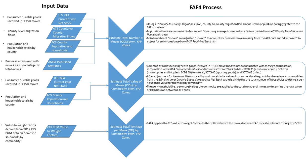 Figure 18. Flow chart. Methodology for household and business moves. Figure 18. Flow chart. Methodology for household and business moves.(Source: Oak Ridge National Laboratory, The Freight Analysis Framework Version 4 (FAF4) Building the FAF4 Regional Database: Data Sources and Estimation Methodologies, September 2016.) Estimate Total Number of Moves (Origin-Destinations) between Freight Analysis Framework ZonesWith these assumptions in-place, the HH&B flows estimation process begins by obtaining county-to-county migration flows from the ACS. These flows are then aggregated to the FAF-zone level. Population flows are converted to household moves by applying the average household size factors generated using Census population and housing unit data for each region as demonstrated in table 4. Households are assumed to move as one unit (as opposed to individual household members making individual moves). 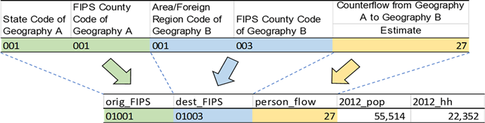 Figure 19. Sample chart. Example record of American Community Survey county migration flows.
(Source: U.S. Census Bureau, American Community Survey, County-to-County Migration Flows.) The resulting FAF-zone totals are then adjusted to account for business and self-moves based on the AMSA published statistics. The total FAF-zone moves are adjusted "upward" to include business moves, those associated with "corporate and other Federal Government" entities. It is adjusted downward to exclude unassisted consumer moves. Estimate Total Value of Moves (Origin-Destinations) by Commodity between Freight Analysis Framework ZonesThe total value per move is then estimated using data from the 2012 BEA Current-Cost Net Stock table. The national total in that table is divided by the total number of households to derive a per-household value for each of the commodity codes at the national level after adjusting to eliminate items that are unlikely to be transported in a moving truck. These national per-household values are then multiplied by the total number of mover-households from each region to obtain values of SCTGs associated with the HH&B OOS flows. Estimate Total Tonnage per Move (Origin-Destinations) by Commodity between Freight Analysis Framework ZonesWith the total value per move in hand, the FAF4 then estimates weight. This is done by applying the CFS value-to-weight factors to the dollar values of the moves to estimate shipment weights by SCTG. ResultsThe FAF4 estimates that 29 million tons, valued at over $128 million, of HH&B goods were generated in 2012. More than half (about 56 percent) of the total value of these shipments are for common household items of SCTG 39 (furniture) and 35 (electronic). All HH&B are assumed to move by truck. Crude PetroleumThe CFS does not include shipments from NAICS subsector 211 (Oil and Gas Extraction). This includes shipments from the field or marine terminals, international pipelines to refineries or long-term storage facilities which is covered under SCTG 16 Crude Petroleum Oil. The FAF4 considers both foreign and domestic crude petroleum shipments under this OOS component. DataThere are three primary data sources that the FAF4 relies on for OOS Crude Petroleum flows:
Data from the Energy Information AdministrationThe EIA publishes several tables and databases that provide the fundamental data necessary for the estimation methodology for OOS Crude Petroleum flows. These include:
The first data discussed is the Movement of Crude by Rail table which contains monthly and annual rail crude oil movements as well as providing crude movement regions.37 This table provides detailed movements among PADDs as well as trade between PADDs and Canada. The FAF4 uses the data in this table as control totals for domestic, U.S. exports to Canada, and U.S. imports from Canada on crude by rail. 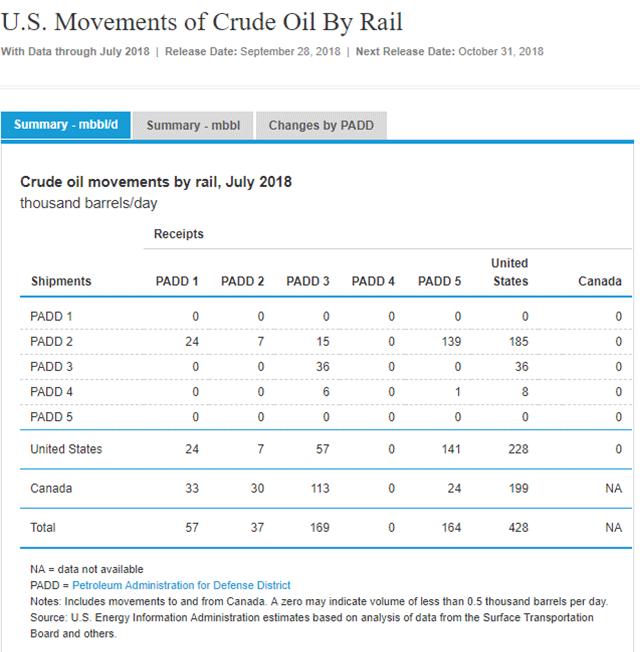 Figure 20. Sample chart. Movements of crude oil by rail.
(Source: U.S. Energy Information Administration.) The EIA's Company-Level Imports database contains monthly statistics on imports of crude and petroleum products at the company level.38 Specific information provided in this database includes importing company name and country, product name, port of entry location, and import quantity, among others. The Crude Petroleum Production table contains information on the annual production of crude petroleum by State and PADD.  Figure 21. Sample chart. Company level imports.
(Source: U.S. Energy Information Administration, accessed October 18, 2018.) Due to Federal law, U.S. companies are limited in their ability to export crude oil.39 The Exports by Destination table published by the EIA detail the amount and destination of exported crude oil.40 In 2012, the only exported crude petroleum from the U.S. was a total of approximately 24.7 million barrels to Canada and about 5 thousand barrels to Mexico. Similarly, the Exports by PADD table provides the annual volume of crude petroleum (in thousand barrels) exported from each PADD.41 This provides control totals for exported crude by PADD. The Movements by Tanker, Pipeline, Barge, and Rail between PADD Districts table contains the annual volumes of crude petroleum movements between PADDs.42 The EIA publishes annual data on refinery net inputs for crude petroleum by PADD and refining regions, which are at the sub-PADD level. These data represent the total crude petroleum (domestic plus foreign) input to crude petroleum distillation units and other refinery processing units. Carload Waybill SampleThe Carload Waybill Sample, published by the Surface Transportation Board, is a stratified sample of carload waybills for all U.S. rail traffic submitted by those rail carriers terminating 4,500 or more revenue carloads annually.43 The FAF4 uses the Carload Waybill Sample in its estimation of crude oil imports and exports by rail. County Business PatternsPayroll data from the County Business Patterns database in used by the FAF4 to estimate crude petroleum production shares at the county level. The CBP payroll shares for the "Crude Petroleum and Natural Gas Extraction" industry (NAICS 211111) are used to disaggregate total State-level production volume to the county level. Table 7 shows an example of CBP payroll data with the payroll shares calculated for NAICS 211111 businesses by county. (Source: U.S. Census Bureau, 2016 County Business Patterns.)MethodologyAs shown in figure 22, the FAF4 methodology for estimating crude petroleum commodity flows begins by using the U.S. EIA data on crude petroleum movements between PADDs to establish control totals for domestic movements at the PADD level.44 Those totals are then disaggregated to the FAF-zone level. Next, the FAF4 estimates the amount of crude petroleum imported by rail and other modes. It likewise estimates the amount of crude petroleum exported by rail and by truck. The remainder of this section provides greater details on the specific steps involved in the crude petroleum estimation methodology.  Figure 22. Flow chart. Methodology for crude petroleum shipments.
(Source: Oak Ridge National Laboratory, The Freight Analysis Framework Version 4 (FAF4) Building the FAF4 Regional Database: Data Sources and Estimation Methodologies, September 2016.) Estimate Domestic Crude Petroleum FlowsThe FAF4 first uses the EIA data on movements between PADDs to establish control totals for domestic movements of oil at the PADD level. Those totals are disaggregated to the FAF-zone level using the following process which is conducted separately in O-D matrices for each mode:
Estimate Rail Imported Crude Petroleum FlowsThe FAF4 process for determining the flow of imported crude oil by rail begins by deriving imported crude oil shipment patterns from the 2012 Waybill data. The Waybill data was used to determine foreign origin, domestic origin, and domestic destination for each imported shipment. The domestic origin of an import shipment was estimated based on the first "through state" from the Waybill. Assuming the Waybill data captured the import pattern by rail, the waybill-estimated by weights are used to distribute EIA-based control totals. The shares are calculated based on Waybill estimates for each foreign origin-PADD pair and then applied to EIA numbers to get estimated shipment weights for the FAF. Estimate Crude Petroleum Imported Flows by All Other ModesThe FAF4 process for determining the flow of imported crude oil by all other modes begins by subtracting imports by rail from EIA-company level imports data. Then, the FAF4 assigns the remaining imports by foreign- and domestic-mode. The foreign mode was determined by reviewing the foreign country and port location for countries other than Canada (the import mode was assumed to be water) and for Canada (where the import mode can be water or pipeline depending on the port location's access to the water network and pipeline network). The domestic mode was assigned on the condition that the mode must be able to serve both the port (domestic origin) and facility location (domestic destination). After the mode assignment, the company-level imports totals are aggregated into FAF regions. Finally, the value of crude oil is calculated using EIA data on imported crude oil prices for each region. Estimate Rail Exported Crude Petroleum FlowsThe process for estimating exports by rail is similar to the process used for imports. The weight shares are calculated based on Waybill estimates for each origin PADD-foreign country pair and applied to EIA numbers to get estimated weights for the FAF. The value of crude oil is calculated based on EIA data on reported crude price. Estimate Truck Exported Crude Petroleum FlowsThe remaining crude exports are assumed to be transported via truck. Based on EIA data obtained from the Exports by Destination table, only Canada and Mexico received crude petroleum from the U.S. in 2012. The domestic origin of exported crude is assumed to be in the FAF region that produces crude oil. The amount of originating flow was estimated using the product of the production share of its PADD and the total flow originating from the given PADD, as obtained from the Exports by PADD table. Both domestic mode and foreign mode are assigned as truck for these shipments. The value of crude oil is then calculated based on the EIA-reported price to complete the resulting matrix. ResultsThe FAF4 estimated a total of $553 billion weighing 869 million tons of crude petroleum shipments were transported by rail and truck in 2012. Natural GasLike crude petroleum, natural gas movements associated with extraction (NAICS 211: Oil and Gas Extraction) are not included in the CFS sampling frame and is thus considered an OOS commodity. DataThe principal data sources used to generate natural gas tonnage and value estimates include publications from the EIA and the Federal Energy Regulatory Commission (FERC). Specifically, the FAF4 utilizes:
The 2012 Natural Gas Annual produced each year by the EIA provides the baseline State-level data on interstate movements of natural gas for the FAF4. Specifically, table 12 of this report entitled "Interstate movements and movements across U.S. borders of natural gas by State" is utilized. For domestic shipments, only the interstate shares are considered. Other data are also used to disaggregate the data from the table into FAF regions:
Data on intrastate natural gas movements also comes from "table 13. Additions to and withdrawals from gas storage by State" in the 2012 Natural Gas Annual. Information on dry production and withdrawals from underground storage by individual States is used to create control totals for intrastate natural gas movements. The same auxiliary data used to support the disaggregation on interstate natural gas movement data is used for intrastate movements. 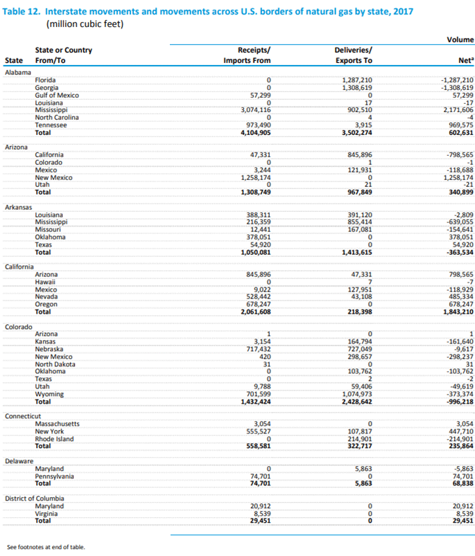 Figure 23. Sample chart. Interstate movements and movements across U.S. borders of natural gas.
(Source: U.S. Energy Information Administration, "Table 12. Interstate Movements and Movements Across U.S. Borders of Natural Gas, 2013–2017," Natural Gas Annual: 2017, September 28, 2018.) 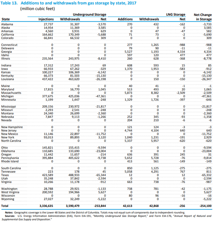 Figure 24. Sample chart. Additions to and withdrawals from gas storage by State.
(Source: U.S. Energy Information Administration, "Table 13. Additions to and withdrawals from gas storage by State, 2017," Natural Gas Annual: 2017, September 28, 2018.) The 2012 Natural Gas Annual is also the primary data source for estimating imported natural gas flows. Specifically, table 9 entitled "Summary of U.S. natural gas imports by point of entry, 2008–2012" of the report is used. The table provides volume (in millions of cubic feet) and average prices of natural gas transported by pipeline and liquefied natural gas (LNG). The report does not specify the mode of transport for imported LNG. However, the FAF4 assumes that LNG imported from countries other than Canada and Mexico arrives by ship. In addition to imports by point of entry, the EIA also reports on natural gas imports by State. The FAF4 assumes that an imported natural gas shipment is delivered to U.S. destinations within the same State where its point of entry is located. This assumption is based on the observation that natural gas is mostly transported by pipeline domestically. Furthermore, the FAF4 assumes that the destinations of imported natural gas are processing plants. The FAF4 utilizes a database of natural gas processing plant locations to determine the destinations of natural gas shipments. 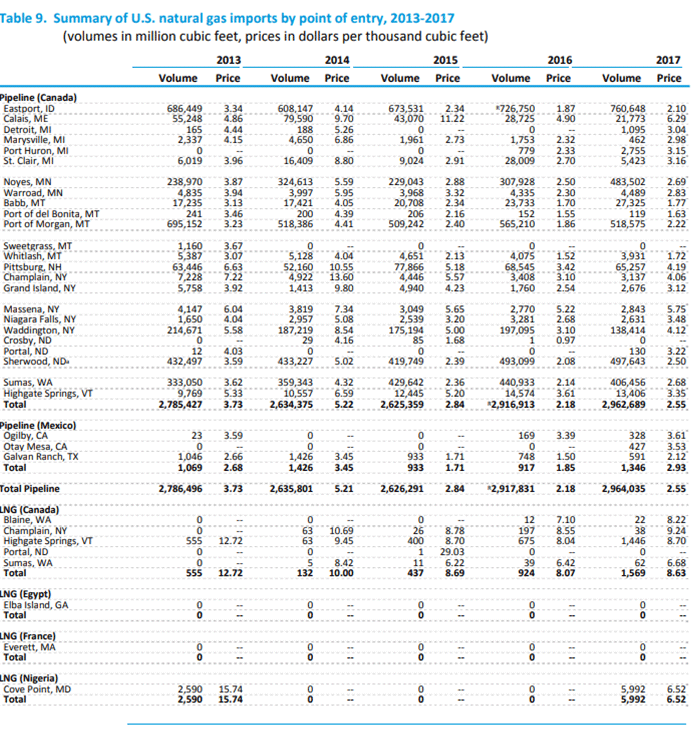 Figure 25. Sample chart. Natural gas imports by point of entry.
(Source: U.S. Energy Information Administration, "Table 9. Summary of U.S. natural gas imports by point of entry, 2013-2017," Natural Gas Annual: 2017, September 28, 2018.) The FAF4 relies on the same data sources for export natural gas movements as import natural gas movements. The same entry points for imports serve as exit points for exports. However, unlike imports, LNG transported to Canada and Mexico can be transported by land modes while for all other countries ship is the assumed mode. Similar to the assumptions on imports of natural gas, the FAF4 assumes that exported natural gas originates in the same State as its point of exit. Thus, receipt points where the gathering system connects to the transmission pipeline are treated as the domestic origins for export flows. The database on receipt point locations discussed earlier for imports are used to identify origin FAF4 zones for exported flows. 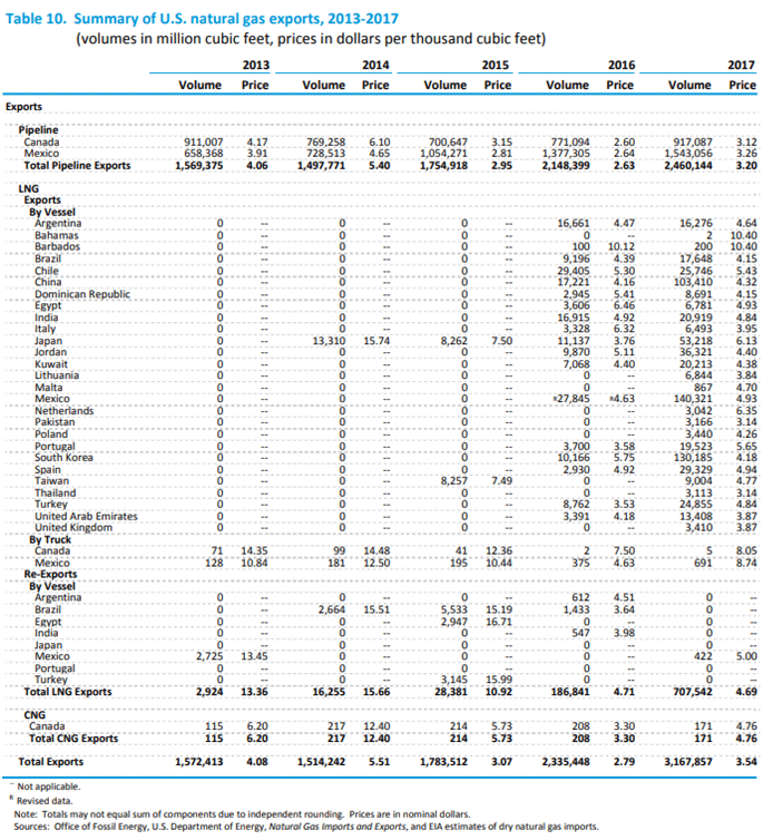 Figure 26. Sample chart. Summary of natural gas exports. Figure 26. Sample chart. Summary of natural gas exports.(Source: U.S. Energy Information Administration, "Table 10. Summary of U.S. natural gas exports, 2013–2017," Natural Gas Annual: 2017, September 28, 2018.) MethodologyFigure 27 outlines the FAF4 methodology for estimating natural gas commodity flows.46 Domestic natural gas movements are disaggregated from the State- to the FAF4-zone level through the development of a gravity model and the application of the IPF process. The gravity model is developed to estimate the initial natural gas O-D matrix. Once the initial matrix is produced, the IPF procedure is applied to generate the final natural gas flow matrix for the FAF4. The remainder of this section provides greater detail on the specific steps implemented in the methodology.  Figure 27. Flow chart. Summary of natural gas exports.
(Source: Oak Ridge National Laboratory, The Freight Analysis Framework Version 4 (FAF4) Building the FAF4 Regional Database: Data Sources and Estimation Methodologies, September 2016.) Estimate Interstate Natural Gas FlowsInterstate movements of natural gas are estimated by first extracting the State-to-State movements (which serve as control totals) from table 12 of the 2012 Natural Gas Annual. The production of natural gas at the FAF4-zone level is estimated by aggregating the scheduled capacity of receipt points into FAF4 zones. The attraction (i.e., consumption) of natural gas at the FAF4-zone level is first estimated by end-use consumption sector at the county level and then aggregated to the FAF4-zone level using one of the following methods which are specific to consumption type:
The total consumption by FAF4 zone is obtained by adding the end-use consumption sector estimates for counties within each FAF4 region. A rank matrix of distance is used in this process. The initial assignment uses a gravity model by utilizing the production and attraction estimates applied to the spatial interaction procedure. Then, with the State-level control totals from the EIA data, the assignment and iterative proportional fitting are repeated for all State-to-State records until the predetermined level of convergence is met. Estimate Intrastate Natural Gas FlowsThe FAF4 follows a similar process for estimating intrastate natural gas flows as it does for interstate movements. The primary difference is the preparation of the State-level data. Because this information is not directly available from the EIA, the FAF4 derives it using data from tables S1—S52 in the 2012 Natural Gas Annual. Data on "dry production" and "withdrawals from underground storage" from the Natural Gas Annual is used to derive intrastate-level flows that serve as control totals for the gravity model. The FAF4 then uses the location and "scheduled capacity" data on natural gas receipt/delivery points to disaggregate intrastate-level production data to the FAF-zone level. Using total "volumes delivered to consumers" from the Natural Gas website, the FAF4 distributes intrastate natural gas flows within States by the end-use sectors of residential, commercial, industrial, vehicle, and electric power. It then uses payroll share data for the NAICS 211111 industry sector (Crude Petroleum and Natural Gas Extraction) from the County Business Patterns database as well as information on population data, vehicle population data, and electric generating units from ancillary databases to disaggregate intrastate-level consumption among FAF zones. Estimate Imported Natural Gas FlowsTo estimate imported natural gas flows, the FAF4 first obtains data on the amount and value of imported natural gas at the State level from the "Summary of U.S. natural gas imports by point of entry, 2008–2012" table from the Natural Gas Annual as well as "U.S. Natural Gas Imports by State" from the EIA. Using Geographic Information System (GIS), the FAF4 assigns natural gas points of entry to FAF4 zones. The FAF4 then obtains data on the locations of "natural gas processing plants" and again uses GIS to assign these facilities to FAF4 zones. The FAF4 assumes that imported natural gas shipments are delivered by pipeline to the States in which they are consumed. For each import record, a domestic FAF4 zone is assigned by identifying the FAF4 zone with a processing plant that is closest to the entry point of imported natural gas. In this manner, FAF4 disaggregates State-level natural gas imports to FAF4 zones within the State. Natural gas imports from Canada are assumed to use truck as the foreign mode. For other countries, the foreign mode as provided in the EIA data is retained. Pipeline is the assumed domestic mode for all shipments. Lastly, natural gas volumes are converted to tons and values of shipments are estimated. Estimate Exported Natural Gas FlowThe FAF4 procedure for estimating exported natural gas flows follows a similar logic as the process for imported natural gas flows. The FAF4 first obtains data on the amount and value of exported natural gas at the State level from the "Summary of U.S. natural gas exports by point of exit, 2008–2012" table from the Natural Gas Annual as well as "U.S. Natural Gas Exports by State" from the EIA. Using GIS, the FAF4 assigns "natural gas processing plants" to FAF4 zones based on their location data. The FAF4 again uses GIS and location data to assigns natural gas points of exit to FAF4 zones. For each export record, a domestic FAF4 zone is assigned by identifying the FAF4 zone with a processing plant that is closest to the exit point of exported natural gas. In this manner, FAF4 disaggregates State-level natural gas exports to FAF4 zones within the State. Natural gas exports to Canada are assumed to use truck as the foreign mode. For other countries, the foreign mode as provided in the Energy Information Agency data is retained. Pipeline is the assumed domestic mode for all shipments. Lastly, natural gas volumes are converted to tons and values of shipments are estimated. ResultsThe FAF4 estimated a total of $827 billion weighing 2.42 billion tons of natural gas shipments were transported in 2012. Foreign TradeThough there are highly developed datasets on which to base FAF4 estimates of import and export flows, there is a lack of geographic detail for inland movements. This creates significant gaps in the regional commodity flow picture. The FAF4 defines imports as shipments originating in one of eight foreign zones and terminating inside the U.S. in one of the 132 domestic FAF4 zones. Upon entering the U.S., these imports pass through a port of entry. Imports from Canada and Mexico are generally assumed to enter at U.S. border crossings with no change in mode, unless an unreasonable domestic mode was encountered. Imports from other countries are assumed to enter via U.S. ports or airports. Similarly, the FAF4 defines exports as shipments that originate from one of the FAF4 zones, pass through a U.S. port of exit, and end in a foreign country. As in the imports, domestic modes of exported shipments terminating in Canada or Mexico are assumed the same as their foreign modes, except for unreasonable modes. There is a significant gap in knowledge of freight movements of imports after they enter the country and of freight movements of exports before they exit the country. There is no readily available dataset on which the FAF4 can rely that covers these movements in terms of geographic details or mode of transportation. For trade with Canada and Mexico, there is some State-level origination and destination data available with which to estimate the domestic leg of their movements. However, for seaborne and airborne shipments from other nations this is not the case. While the CFS does not capture imports, it may include movements of imported goods that change ownership once they arrive in the U.S. The FAF4 assumes that most of the imports that remain within a port region are moved internally with that region by truck. DataThe FAF4 relies on five primary data sources. Four of those five datasets are provided by the U.S. Census Bureau with the remaining dataset provided by IHS Markit, Inc.
Census Foreign Trade Public Data is produced by the Foreign Trade Division of the U.S. Census Bureau. The dataset provides information on all air and vessels engaged in U.S. foreign trade only as other modes are not included. It includes cargo data by type of service, U.S. and foreign ports involved, country of origin or destination, commodity, value and tonnage, for both bulk and containerized cargo. For waterborne trade, the Census Foreign Trade Public Data covers both seaborne and Great Lakes international commodity movements. In the publicly available version of the Census Foreign Trade Public Data, no specific location information on U.S. origins or destinations on shipments is provided. In addition, commodity information is provided according to the Harmonized System codes (HS) classification as opposed to SCTG which the FAF4 uses to report commodity flows. In order to overcome the limitations of the public version of the Census Foreign Trade Public Data, the Census made available to the Bureau of Transportation Statistics (BTS) special tabulations of the foreign trade data that provided more details on the domestic segments of foreign-trade shipments. Generally, the special tabulations provide the State-level origin/destination, commodity, and port of entry/exit at the FAF4-zone level. The data also provided commodity information using SCTG codes as opposed to Harmonized System (HS) codes as is done in the publicly available version. In addition to the data on "direct" trade (i.e., shipments moved between the U.S. and a foreign country with no interim stops), the Census also provided data on "indirect" trade (i.e., shipments moved between the U.S. and a foreign country via Canada or Mexico). For example, a shipment that begins in Europe, moves across a portion of Canada, and terminated in Boston would be considered in this portion of the data. The FAF4 considers these shipments as origin-destination commodity mode (ODCM) flows between the U.S. and Canada or Mexico regardless of the endpoint in another foreign country. However, since the foreign trade data only records the mode of travel between Canada/Mexico and the other foreign country, the FAF4 assigns all of these shipments to the "multiple mode" for their foreign segments as opposed to water or air. Figure 28 shows an example of the data elements contained within the Census-provided U.S.A. Trade Online special table, along with example records illustrating the information it contains. These data elements are:
 Figure 28. Sample chart. Example tabulation of foreign trade data.
(Source: Federal Highway Administration.) The Transborder Surface Freight Data provides more detail on trade involving Canada and Mexico than is available from the Census Foreign Trade Public Data. It provides more information on the mode used in the border crossing—truck, rail, vessel, air, pipeline, mail, and other as opposed to only air and vessel as is provided in the Census Foreign Trade Public Data. Furthermore, the Transborder data specifies the domestic origin/destination of a shipment at the State level. However, like the Foreign Trade data, commodity information is provided according to the HS classification as opposed to SCTG. Also, the Transborder data provides only two of three key pieces of information for determining a complete commodity flow: (1) domestic origin or destination at the State level, (2) port of entry or exit, and (3) commodity shipped. Traditionally, the FAF has relied on modeling approaches to "fill in the gap" and develop a complete State-port-commodity matrix as the first step in estimating ODCM flows. Like other OOS commodities, payroll information from the 2012 CBP database is used to disaggregate State-level estimates to their corresponding FAF4 regions. The CBP data was previously discussed in the section on retail commodity flows. The PIERS dataset, available from IHS Markit, Inc., contains detailed information from the Bills of Lading records of the cargoes on- and off-loaded at U.S. ports from ships facilitating foreign trade. The PIERS database records information on the port (by custom district), tons, dollar value, commodity (6-digit HS codes), container count (if it is a container ship), foreign country of origin or destination, and the shipper. The PIERS data allows for an accurate and straightforward determination of the value and tonnage for a given port region, foreign country, and commodity. However, the Port of New York and New Jersey is contained in a single custom district whereas FAF4 zones do not extend across State lines. For simplicity, the FAF4 assumes all activities involving this custom district occur within the New Jersey FAF4 zone in which a portion of the port is contained (FAF4 zone 341). MethodologyAs shown in figure 29, the FAF4 estimates foreign trade flows by first disaggregating commodity groups from 1-digit groupings (as they are provided by the Census) to 2-digit SCTG groups. The FAF4 then imputes flows for foreign trade shipments with unknown States. For trade involving unknown States of origin or destination, the FAF4 allocates these volumes proportionally based on trade records that share the same shipment characteristics. Next, the FAF4 estimates flows with unspecified port zones. These are Census-designated special codes for ports that do not correspond to FAF4 figure 29 zones for shipments that meet certain conditions. Next, using value-to-weight ratios derived from data on imports using information on the country of origin, transportation mode, and commodity type, the FAF4 estimates missing shipment weights and values. After that, the FAF4 assigns a domestic mode and disaggregates State-level flows to the zone level. Lastly, the FAF4 makes assumptions on the domestic legs of foreign waterborne shipments as the PIERS and Census data do not explicitly define these movements.48 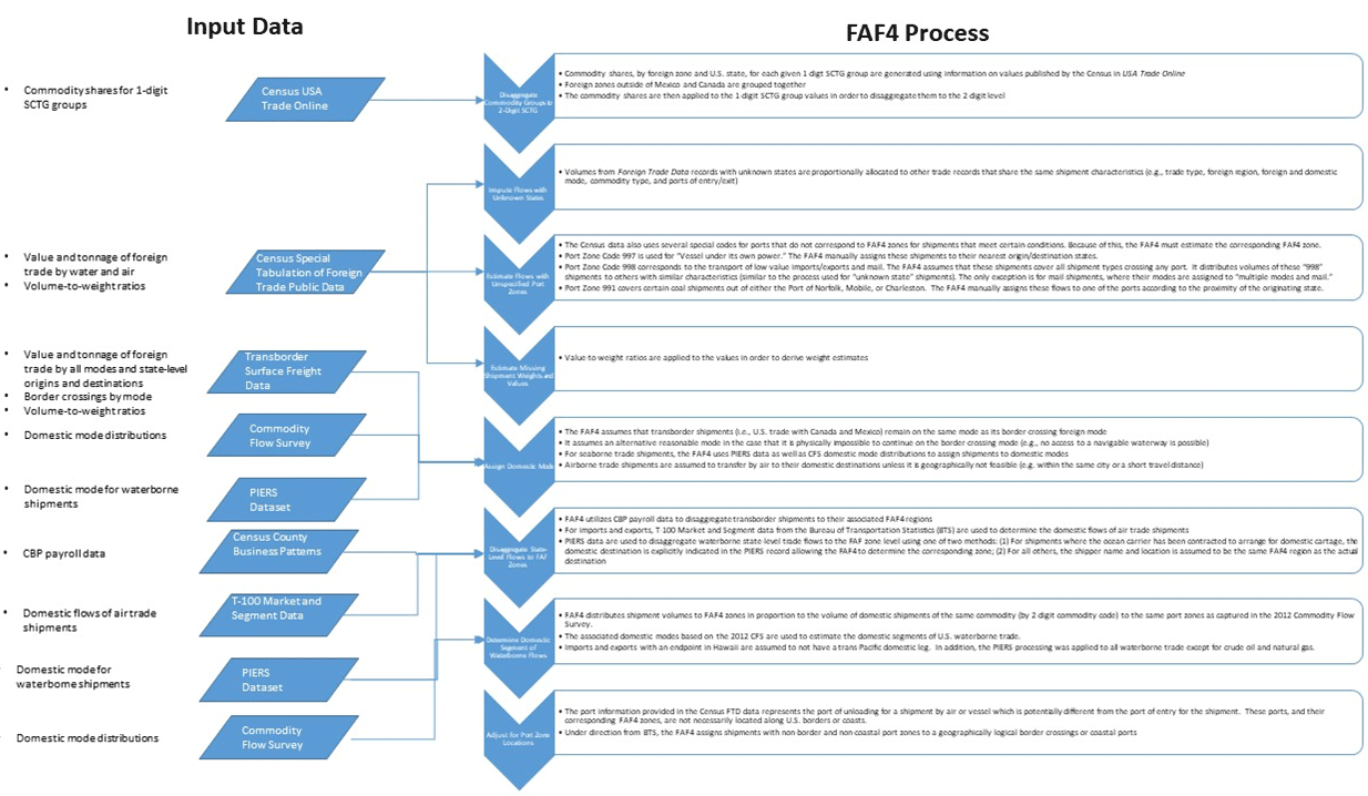 Figure 29. Flow chart. Methodology for foreign trade shipments.
(Source: Oak Ridge National Laboratory, The Freight Analysis Framework Version 4 (FAF4) Building the FAF4 Regional Database: Data Sources and Estimation Methodologies, September 2016.) Disaggregate Commodity Groups to 2-Digit Standard Classification of Transported GoodsIn order to maintain privacy, the Census aggregates commodities into less detailed 1-digit commodity groups instead of the 2-digit SCTG groups as done in the FAF4. Therefore, the first step in the process for estimating freight flows from the Foreign Trade data is to disaggregate these 1-digit SCTG groups into their associated 2-digit codes. First, commodity shares for each given SCTG group are generated using information on the value of trade for those commodities published on the Census' USA Trade Online website.49 Those 1-digit commodity value shares (i.e., percentages) are then multiplied by their associated tonnages to develop an estimate of tonnage by 2-digit commodity code. To account for regional variations in commodities being shipped, commodity shares are summarized by both foreign zone and the U.S. State involved. However, foreign zones outside of Canada and Mexico are grouped together assuming that commodity shares are the same within these zones. In this manner, both import and export trade tonnages were estimated. Impute Flows with Unknown StatesIn addition to the Census data aggregating trade shipments to the 1-digit SCTG code level, it also reports trade data with an "unknown State" as the origin or destination. For trade involving unknown States of origin or destination, the FAF4 allocates these volumes proportionally based on trade records that share the same shipment characteristics (i.e., import or export, foreign region, transportation mode to enter or exit the U.S., commodity type, and port of entry or exit). Estimate Flows with Unspecified Port ZonesThe Census data also uses several special codes for ports that do not correspond to FAF4 zones for shipments that meet certain conditions. Because of this, the FAF4 must estimate the corresponding FAF4 zone. The special port codes for which the FAF4 must estimate corresponding zones includes:
Estimate Missing Shipment Weights and ValuesThe Census data do not include information on weight for many export shipments. In addition, some records do not contain data on values, which must also be estimated. For these records, the FAF4 applies value-to-weight ratios derived from data on imports using information on the country of origin, transportation mode, and commodity type. Assign Domestic ModeIn assigning a domestic mode for foreign trade shipments, the FAF4 assumes that transborder shipments (i.e., U.S. trade with Canada and Mexico) remain on the same mode as its border-crossing foreign mode. In the case that it is physically impossible to continue the border-crossing mode (e.g., no access to a navigable waterway is possible), the FAF4 assigns another reasonable mode (e.g., truck, rail, or multiple mode). For seaborne trade shipments, the FAF4 uses PIERS data as well as CFS domestic mode distributions to assign shipments to domestic modes. Airborne trade shipments are assumed to transfer by air to their domestic destinations unless it is geographically not feasible (e.g., within the same city or a short travel distance). Disaggregate State-Level Flows to Freight Analysis Framework ZonesThe FAF4 then disaggregates State-level flows to FAF4 regions. As in the processing of other OOS commodities, the FAF4 utilizes CBP payroll data to disaggregate transborder shipments to their associated FAF4 regions. For imports and exports, T-100 Market and Segment data from the BTS are used to determine the domestic flows of air trade shipments.50 For waterborne trade, the PIERS data are utilized. Determine Domestic Segment of Waterborne FlowsThough the PIERS data is used to disaggregate waterborne shipments to the FAF4 level, it does not explicitly provide this information. Instead, it must be inferred from one of two components of the data:
When the domestic destination of a shipment is unknown, the FAF4 distributes the volume of this shipment to FAF4 zones in proportion to the volume of domestic shipments of the same commodity (by 2-digit commodity code) to the same port zones as captured in the 2012 Commodity Flow Survey. Similarly, the associated domestic modes based on the 2012 CFS are used to estimate the domestic segments of U.S. waterborne trade. Furthermore, imports and exports with an endpoint in Hawaii are assumed to not have a trans-Pacific domestic leg. In addition, the PIERS processing was applied to all waterborne trade except for crude oil and natural gas. Adjust for Port Zone LocationsLastly, the port information provided in the Census Foreign Trade Division data represents the port of unloading for a shipment by air or vessel which is potentially different from the port of entry for the shipment. These ports, and their corresponding FAF4 zones, are not necessarily located along U.S. borders or coasts. Under direction from the BTS, the FAF4 assigns shipments with nonborder and noncoastal port zones to a geographically logical border crossings or coastal ports. ResultsThe FAF4 estimated a total of $1.4 billion weighing 3,410 billion tons of foreign trade shipments were transported in 2012. SummaryAs shown in table 8, the FAF4 relies on several different types of data gathered from various sources. However, the majority of data come from other Federal agencies, namely the U.S. Census Bureau, National Agricultural Statistics Service, National Oceanic Atmospheric Administration, U.S. Forest Service, BTS, U.S. Bureau of Economic Analysis, and the U.S. Energy Information Agency. Just as the majority of data for the FAF4 comes from a relatively small number of Federal agencies, it also uses data from relatively few sources within those agencies. The primary data sources are the Commodity Flow Survey, Economic Census, Census of Agriculture, Vehicle Inventory and Use Survey, County Business Patterns, and the American Community Survey. These data sources are broadly used across OOS commodity methodologies. The FAF4 data acquired from the various public-sector and industry sources are also updated according to different schedules. For example, the Economic Census (including the Commodity Flow Survey) and the Census of Agriculture are updated every 5 years in years ending in "2" and "7." Data from the County Business Patterns, American Community Survey, Retail Trade Survey, Service Annual Survey, and the various tables published by the U.S. Energy Information Agency, among others, are updated annually. Other data sources on which the FAF4 relies have less consistent updates. Most notably, the VIUS is discontinued. The State of Garbage in America Survey in recent years transitioned from the BioCycle Journal to Columbia University, so it is unclear if this data source will continue to exist or the frequency with which it will be updated. Though reports on municipal solid waste and C&D debris production and movements are typically produced annually by States, this is not always the case. Furthermore, not all States produce these reports requiring the FAF4 to supplement with data from the State of Garbage in America Survey. (Source: Federal Highway Administration.)In general, the FAF4 uses the results of the Commodity Flow Survey (CFS) to develop an origin-destination-commodity-mode (ODCM) matrix of freight shipments. Because the CFS suppresses some shipment information either due to shipper privacy concerns or statistical reliability, the FAF4 estimates a log-linear effects model using iterative proportional fitting procedure to develop a complete ODCM matrix. The FAF4 deploys a similar methodology for estimating O-D flows for OOS commodities with data sources that do not provide complete information on where those commodities are ultimately consumed, namely crude petroleum and natural gas shipments. For crude petroleum and natural gas shipments, the FAF4 estimates gravity models via iterative proportional fitting in order to distribute productions of crude petroleum and natural gas to destination FAF4 zones. From the assessment of the data sources and methodologies supporting the estimation of the OOS commodity flows, a number of limitations/opportunities for improvement are identified. These are summarized in table 9. The identified limitations/potential opportunities for improvement are in the areas of improved data and methodological changes. Table 10 contains estimates of the total weight and value of out-of-scope commodity flows. While some of these estimates were provided directly by FAF4 documentation,51 others were estimated from the FAF4 Data Tabulation Tool. The purpose of the analysis is to determine which commodities comprise the largest shares of the 30 percent of total FAF4 commodity flows that constitute out-of-scope shipments. The results of the analysis indicate that Foreign Trade, Crude Petroleum, Natural Gas, and Farm-Based Shipments are the largest out-of-scope commodity groups by total tonnage and value. These commodities are estimated to comprise over 81 percent of OOS commodity flows by tonnage and nearly 94 percent by value. Therefore, improvements to the data and methodologies supporting these commodities would potentially result in relatively large improvements to the FAF4 overall. (Source: Federal Highway Administration.)
Note: 1 The FAF4 documentation indicates that municipal solid waste and construction and demolition debris have no value associated with those flows. [Return to note 1] 2 From the FAF4 Data Tabulation Tool, total flows of Crude Petroleum (SCTG 16) accounted for nearly 869 million tons valued at over $553 billion. [Return to note 2] 3 From the FAF4 Data Tabulation Tool, total flows of Coal-n.e.c. (SCTG 19), which includes natural gas, accounted for nearly 2.42 billion tons valued at over $827 billion. However, this estimate includes petroleum products other than natural gas (e.g., propane, butane, petroleum asphalt, etc.). [Return to note 3] 4 From the FAF4 Data Tabulation, the total tonnage and value of all imports and exports was calculated. Foreign trade tonnage and value for Crude Petroleum (SCTG 16) and Coal-n.e.c. (SCTG 19) were omitted from this estimate since the FAF4 OOS methodology estimates those values separately for those commodities. [Return to note 4] 2 Oak Ridge National Laboratory, The Freight Analysis Framework Version 4 (FAF4) Building the FAF4 Regional Database: Data Sources and Estimation Methodologies, pages 19–20, September 2016. [Return to footnote 2] 3 U.S. Department of Agriculture. [Return to footnote 3] 4 U.S. Department of Agriculture, Agricultural Statistics, 2013. [Return to footnote 4] 5 U.S. Department of Agriculture, Final Estimates Statistical Bulletins. [Return to footnote 5] 6 U.S. Census Bureau, Vehicle Inventory and Use Survey. [Return to footnote 6] 7 U.S. Census Bureau, Commodity Flow Survey. [Return to footnote 7] 8 Oak Ridge National Laboratory, The Freight Analysis Framework Version 4 (FAF4) Building the FAF4 Regional Database: Data Sources and Estimation Methodologies, pages 20–23, September 2016. [Return to footnote 8] 9 U.S. Department of Agriculture, Agriculture Census, 2012. Table 2. Market Value of Agricultural Products Sold Including Direct Sales: 2012 and 2007. [Return to footnote 9] 10 U.S. Department of Agriculture, Agricultural Statistics, 2013. [Return to footnote 10] 11 At the national level, in 2012 an estimated 16,996,146.11 KTons of commodities valued at $17,729,210.22 (million $) were moved in the U.S. Freight Analysis Framework Data Tabulation Tool. [Return to footnote 11] 12 Oak Ridge National Laboratory, The Freight Analysis Framework Version 4 (FAF4) Building the FAF4 Regional Database: Data Sources and Estimation Methodologies, page 25, September 2016. [Return to footnote 12] 13 Fisheries of the United States 2015. [Return to footnote 13] 14 National Oceanic and Atmospheric Administration, Landings Data. [Return to footnote 14] 15 Oak Ridge National Laboratory, The Freight Analysis Framework Version 4 (FAF4) Building the FAF4 Regional Database: Data Sources and Estimation Methodologies, pages 25–26, September 2016. [Return to footnote 15] 16 Oak Ridge National Laboratory, The Freight Analysis Framework Version 4 (FAF4) Building the FAF4 Regional Database: Data Sources and Estimation Methodologies, pages 26–27, September 2016. [Return to footnote 16] 17 Forest Inventory and Analysis National Program, Data and Tools. [Return to footnote 17] 18 Forest Inventory and Analysis National Program, Program Features: Timber Products Output Studies. [Return to footnote 18] 19 Oak Ridge National Laboratory, The Freight Analysis Framework Version 4 (FAF4) Building the FAF4 Regional Database: Data Sources and Estimation Methodologies, page 27, September 2016. [Return to footnote 19] 20 Oak Ridge National Laboratory, The Freight Analysis Framework Version 4 (FAF4) Building the FAF4 Regional Database: Data Sources and Estimation Methodologies, page 27, September 2016. [Return to footnote 20] 21 Oak Ridge National Laboratory, The Freight Analysis Framework Version 4 (FAF4) Building the FAF4 Regional Database: Data Sources and Estimation Methodologies, page 27, September 2016. [Return to footnote 21] 22 Oak Ridge National Laboratory, The Freight Analysis Framework Version 4 (FAF4) Building the FAF4 Regional Database: Data Sources and Estimation Methodologies, pages 29–30, September 2016. [Return to footnote 22] 23 Oak Ridge National Laboratory, The Freight Analysis Framework Version 4 (FAF4) Building the FAF4 Regional Database: Data Sources and Estimation Methodologies, pages 30–31, September 2016. [Return to footnote 23] 24 Oak Ridge National Laboratory, The Freight Analysis Framework Version 4 (FAF4) Building the FAF4 Regional Database: Data Sources and Estimation Methodologies, page 32, September 2016. [Return to footnote 24] 25 Oak Ridge National Laboratory, The Freight Analysis Framework Version 4 (FAF4) Building the FAF4 Regional Database: Data Sources and Estimation Methodologies, pages 32–33, September 2016. [Return to footnote 25] 26 Oak Ridge National Laboratory, The Freight Analysis Framework Version 4 (FAF4) Building the FAF4 Regional Database: Data Sources and Estimation Methodologies, pages 35–36, September 2016. [Return to footnote 26] 27 United States Census Bureau, Economic Census. [Return to footnote 27] 28 United States Census Bureau, County Business Patterns. [Return to footnote 28] 29 Oak Ridge National Laboratory, The Freight Analysis Framework Version 4 (FAF4) Building the FAF4 Regional Database: Data Sources and Estimation Methodologies, pages 36–37, September 2016. [Return to footnote 29] 30 Oak Ridge National Laboratory, The Freight Analysis Framework Version 4 (FAF4) Building the FAF4 Regional Database: Data Sources and Estimation Methodologies, pages 37–38, September 2016. [Return to footnote 30] 31 United States Census Bureau, Economic Census. [Return to footnote 31] 32 United States Census Bureau, County Business Patterns. [Return to footnote 32] 33 Oak Ridge National Laboratory, The Freight Analysis Framework Version 4 (FAF4) Building the FAF4 Regional Database: Data Sources and Estimation Methodologies, pages 38–40, September 2016. [Return to footnote 33] 34 Oak Ridge National Laboratory, The Freight Analysis Framework Version 4 (FAF4) Building the FAF4 Regional Database: Data Sources and Estimation Methodologies, pages 40–42, September 2016. [Return to footnote 34] 35 Oak Ridge National Laboratory, The Freight Analysis Framework Version 4 (FAF4) Building the FAF4 Regional Database: Data Sources and Estimation Methodologies, pages 42–43, September 2016. [Return to footnote 35] 36 Oak Ridge National Laboratory, The Freight Analysis Framework Version 4 (FAF4) Building the FAF4 Regional Database: Data Sources and Estimation Methodologies, pages 46–48, September 2016. [Return to footnote 36] 37 U.S. Energy Information Administration, Petroleum & Other Liquids: U.S. Movements of Crude Oil By Rail, accessed October 18, 2018. [Return to footnote 37] 38 U.S. Energy Information Administration, Petroleum & Other Liquids: Company Level Imports. [Return to footnote 38] 39 Energy Policy and Conservation Act of 1975 and the Government Publishing Office PL94-163. [Return to footnote 39] 40 U.S. Energy Information Administration, Petroleum & Other Liquids: Exports by Destination. [Return to footnote 40] 41 U.S. Energy Information Administration, Petroleum & Other Liquids: Exports. [Return to footnote 41] 42 U.S. Energy Information Administration, Petroleum & Other Liquids: Movements by Pipeline, Tanker, Barge and Rail between PAD Districts. [Return to footnote 42] 43 2012 Surface Transportation Board Carload Waybill Sample Reference Guide. [Return to footnote 43] 44 Oak Ridge National Laboratory, The Freight Analysis Framework Version 4 (FAF4) Building the FAF4 Regional Database: Data Sources and Estimation Methodologies, pages 49–50, September 2016. [Return to footnote 44] 45 Oak Ridge National Laboratory, The Freight Analysis Framework Version 4 (FAF4) Building the FAF4 Regional Database: Data Sources and Estimation Methodologies, pages 51–53, September 2016. [Return to footnote 45] 46 Oak Ridge National Laboratory, The Freight Analysis Framework Version 4 (FAF4) Building the FAF4 Regional Database: Data Sources and Estimation Methodologies, pages 53–56, September 2016. [Return to footnote 46] 47 Oak Ridge National Laboratory, The Freight Analysis Framework Version 4 (FAF4) Building the FAF4 Regional Database: Data Sources and Estimation Methodologies, pages 58–60, September 2016. [Return to footnote 47] 48 Oak Ridge National Laboratory, The Freight Analysis Framework Version 4 (FAF4) Building the FAF4 Regional Database: Data Sources and Estimation Methodologies, pages 60–64, September 2016. [Return to footnote 48] 49 United States Census Bureau, USA Trade Online. [Return to footnote 49] 50 Federal Aviation Administration, Passenger Boarding (Enplanement) and All-Cargo Data for U.S. Airports. [Return to footnote 50] 51 Oak Ridge National Laboratory, The Freight Analysis Framework Version 4 (FAF4) Building the FAF4 Regional Database: Data Sources and Estimation Methodologies, September 2016. [Return to footnote 51] You may need the Adobe® Reader® to view the PDFs on this page. | |||||||||||||||||||||||||||||||||||||||||||||||||||||||||||||||||||||||||||||||||||||||||||||||||||||||||||||||||||||||||||||||||||||||||||||||||||||||||||||||||||||||||||||||||||||||||||||||||||||||||||||||||||||||||||||||||||||||||||||||||||||||||||||||||||||||||||||||||
|
United States Department of Transportation - Federal Highway Administration |
||