Decision Support Framework and Parameters for Dynamic Part-Time Shoulder Use:
Considerations for Opening Freeway Shoulders for Travel as a Traffic Management Strategy
Appendix B. Dynamic Part-Time Shoulder Use Applications Fact Sheets
I-70 Freeway, Idaho Springs, Colorado
Name of the Facility
I-70
Operating Agency
Colorado Department of Transportation (DOT)
Background
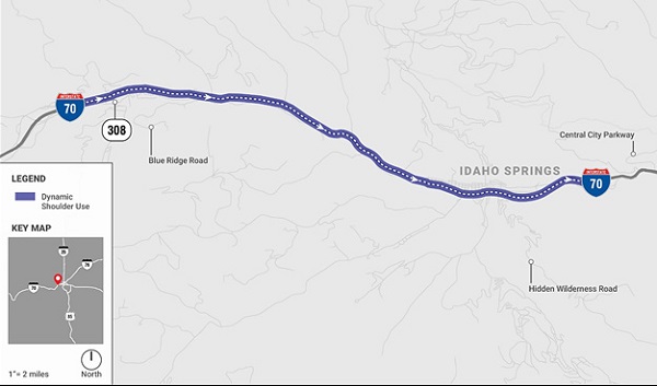
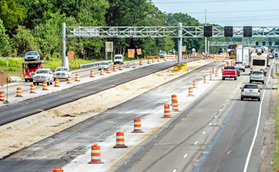
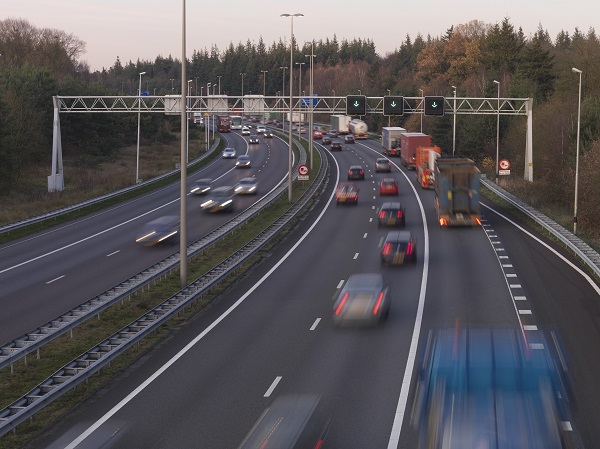
CDOT created the I-70 Mountain Express Lane from a wide shoulder that, only during peak recreational travel periods, operates as a third travel lane in the eastbound direction. This dynamic part-time shoulder lane is dynamically priced and located on the left side of I-70 from US 40/Empire (Exit 232) to Idaho Springs (Exit 241).
Length/Number of Lanes
This roadway section is 13 miles long and operates as dynamic part-time shoulder use (D-PTSU) when extra capacity is needed. This roadway section maintains two (2) lanes plus the D-PTSU on the left.
The lane width for the dynamic shoulder lane is 11 feet. A white solid line separates the travel lanes from the dynamic shoulder and a yellow solid stripe separates the shoulder lane from the median. This shoulder helps relieve the traffic congestion during the holidays and ski season from the Eisenhower/Johnson Memorial Tunnels to the top of Floyd Hill.
Figure 34 shows the map of the D-PTSU in Colorado on I-70.
Date of Implementation/Status
December 2015
Core Time Periods of Operation
Holidays/Weekends: 9 a.m. – 6 p.m. or 9 a.m. – 8 p.m.
Crieria for Opening the Shoulder
The criteria for opening the shoulder was initially traffic volume and the type of the day. During the Christmas week, ski season (i.e., every weekend from Thanksgiving to April 15th), and during some summer weekends, the dynamic shoulder was opened at 9 a.m. in the morning. CDOT has recently begun to open the shoulder at 9 a.m. on all Saturdays and Sundays for consistency.
The days to open the shoulder are largely based on historical data and trends from the previous years. CDOT initially used algorithms that charge the toll price based on traffic density. However, CDOT decided to use fixed price later. The toll rate is $5 on Saturday, $6 on Sunday and occasionally gets increased to $7 as the shoulder lane reaches capacity.
CDOT coordinates with maintenance pickup truck drivers and the operator at the traffic operations center (TOC) (which uses closed-circuit television cameras) to make sure that the shoulder section is free of obstacles, and any debris before opening the shoulder for traffic. After performing these checks, which take about 20 minutes, the dynamic shoulder lane is opened for traffic.
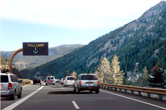
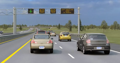
Figure 35 shows the shoulder being open for traffic.
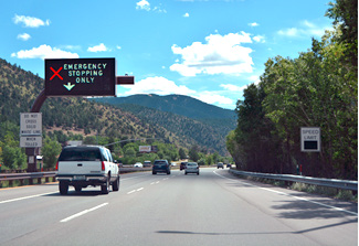
Figure 36 shows the shoulder being closed for traffic.
Source: Kittelson & Associates
Figure 34. Map. Dynamic part-time shoulder use in Colorado.
Source: CDOT, 2018
Figure 35. Photo. Example of dynamic part-time shoulder use open.
Source: CDOT
Figure 36. Photo. Example of dynamic part-time shoulder use closed.
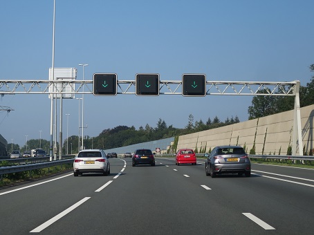
Other ATM Treatments Present
- Variable message signs.
- Lane use signals.
- Variable speed limit signs.
- Variable travel time information sign.
- Ramp meters.
- Supporting intelligent transportation system (ITS) devices.
- Closed circuit television cameras.
- Microware vehicle radar detectors.
- Travel time indicators.
- Weigh in motion system.
Impact Assessment/Results
CDOT noted that with the introduction of the dynamic shoulder use on I-70, there was a 14 percent increase in the throughput, 38 percent improvement in the travel times in general purpose lanes, and 18 percent increase in the speeds across all lanes of eastbound I-70 during high traffic volumes on the weekends. (CDOT, 2017).
Contact Information
Stephen Harelson
West Program Engineer, Region I
Colorado Department of Transportation
Stephen.harelson@state.co.us
720-497-6913
Joe Mahoney
Tolling and Contracts Coordinator
Colorado Department of Transportation
Joe.mahoney@state.co.us
303-757-9152
References
Colorado Department of Transportation (CDOT) (2017). I-70 Mountain Express Lane Project wins Two Awards, CDOT Website. https://www.codot.gov/news/2017-news/january/i-70-mountain-express-lane-project-wins-twoawards
Colorado Department of Transportation (CDOT) (2018). Eastbound I-70 Peak Period Shoulder Lane, CDOT Website. https://www.codot.gov/projects/I70mtnppsl
Interstate Guide (2016). A Dynamic Message Sign for the I-70 Mountain Express Lane on Interstate 70 Eastbound at Dumont. Photo taken: August 2016. https://www.interstate-guide.com/i-070.html
US-23 FREEWAY, ANN ARBOR, MICHIGAN
Name of the Facility
US 23
Operating Agency
Michigan Department of Transportation (MDOT)
Background
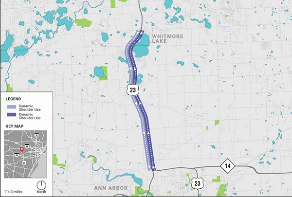
The US 23 roadway section in Washtenaw and Livingston counties between M-14 (Exit 41) to M-36 (Exit 54) is the "FlexRoute." FlexRoute refers to dynamic part-time shoulder use (D-PTSU) on the left side of the roadway in both directions. It is open to traffic in the southbound direction in the a.m. period, and northbound direction in the p.m. period.
Length/Number of Lanes
This roadway section is 8.5 miles long in each direction and operates as a D-PTSU lane when extra capacity is needed. This roadway section maintains existing two (2) lanes, plus the dynamic shoulder on the left.
The lane widths for the dynamic shoulder lane and general travel lanes vary from 11 feet to 12 feet. A single solid yellow stripe is used on both sides of the shoulder lane. The corridor has 70 mi/h speed limit, but the speeds reduce to 60 mi/h when the dynamic shoulder is open to traffic.
Figure 37 shows the map of the FlexRoute dynamic shoulder lane in Michigan on US 23.
Date of Implementation/Status
November 13, 2017
Core Time Periods of Operation
Weekdays: 6 a.m. – 9:30 a.m. (Southbound direction), 3 p.m. – 7 p.m. (Northbound direction). Time periods vary during winter season and during special events.
Criteria for Opening the Shoulder
Parsons/Delcan software is used to make recommendations related to dynamic shoulder open/close operation. The criteria for opening the shoulder is based on traffic volume and vehicles speeds. Roadway section with a traffic volume of greater than or equal to 1400 vehicles per hour per lane (veh/h/ln), and vehicle speeds less than or equal to 60 mi/h are used as threshold values for opening the shoulder.
Historical volume information and algorithms are used for making the decision of opening the shoulder. Since this facility has only been open for several months, operators are still adjusting their procedures and often keeping hours of operation similar to the core (i.e., peak) periods. Once the shoulder is opened, it should stay open for a minimum of 20 minutes before it can be closed for traffic.
MDOT coordinates with the freeway service patrol and operators to make sure that the shoulder section is free of obstacles and any debris before opening it for traffic. It is sometimes difficult for operators to check the roadway surface conditions with cameras because of lack of visibility.
Figure 38 and figure 39 show the shoulder lane in construction and being open for traffic respectively.
Source: Kittelson & Associates
Figure 37. Map. Dynamic part-time shoulder use in Michigan.
Other ATM Treatments Present
- Lane control signs.
- Large/small dynamic message signs.
- Microwave vehicle detection.
- Low-light cameras.
These signs are located every 0.5–1 mile over every lane.
Impact Assessment/Results
MDOT is collecting operational and safety performance measures every month (i.e., travel times, traffic speeds, planning time index, and crashes). However, because the system has only been in operation for a few months, MDOT does not have enough data to carry out any analysis at this time.
Contact Information
Stephanie Palmer
University Region Traffic Safety & Operations Engineer
Michigan Department of Transportation
PalmerS3@michigan.gov
517-750-0422
References
Johnson, P. (2018). Active Traffic Management in Michigan. HNTB, Michigan.
I-35W FREEWAY, MINNEAPOLIS, MINNESOTA
Name of the Facility
I-35W
Operating Agency
Minnesota Department of Transportation (MnDOT)
Background
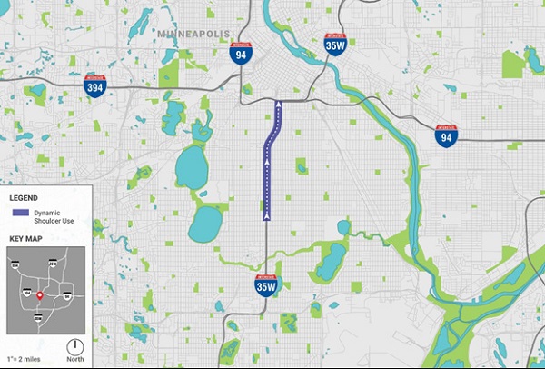
Due to the geometric constraints of I-35W northbound between 42nd Street and downtown Minneapolis, the left shoulder was converted to be a dynamic shoulder lane. PTSU was removed in 2018 as part of a major widening project.
Length/Number of Lanes
This roadway section was 3 miles long and operated as a dynamic shoulder lane when extra capacity was needed. This roadway section had four (4) general purpose lanes plus the dynamic shoulder use (D-PTSU) on the left.
The D-PTSU effectively extended the use of an upstream, high-occupancy toll (HOT) lane to downtown Minneapolis without adding a full-time lane by making use of the existing space. The lane widths for the D-PTSU and general purpose lanes varied from 11 feet to 12 feet, with a buffer of 2 feet between dynamic shoulder lane and general purpose lanes. This separation was by a single solid yellow stripe. An additional yellow stripe was placed along the median barrier to the left of the shoulder lane to improve visibility.
Figure 40 shows the map of the D-PTSU in Minneapolis on I-35W.
Date of Implementation/Status
2009 through June 2018.
Core Time Periods of Operation
Weekdays: 6 a.m. – 10 a.m., 3 p.m. – 7 a.m.
Saturday: 11 a.m. – 7 p.m.
Sunday: 10 a.m. – 6 p.m.
Criteria for Opening the Shoulder
The criteria for opening the shoulder were traffic volume and speed of vehicles on the roadway. MnDOT generally operated the dynamic shoulder lane during the same time periods. Reasons for this included: driver expectancy, and connection to a HOT lane which had fixed times of operation.
The dynamic shoulder lane was generally opened every weekday at 6 a.m., when the HOT lane becomes operational (i.e., toll collection begins). MnDOT coordinated with freeway service patrol to make sure that the shoulder section was free of obstacles and any debris before opening it for traffic.
The dynamic shoulder lane was opened on weekends based on the level of traffic congestion going towards the downtown area. The frequency of this increased over time and it was eventually open most weekends.
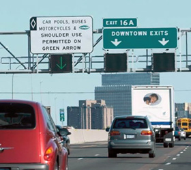
Figure 41 shows the shoulder being open for traffic.
Criteria for Closing the Shoulder
The criteria for closing the shoulder were mainly traffic volume, and vehicle speeds, but traffic safety component was usually considered as well. When a situation arose that seemed to compromise traffic safety, the shoulder lane was closed for travel.
The D-PTSU was closed around 7 p.m. usually, but this operation was more variable in nature. The operator discretion was strongly considered while making the decision to close the shoulder for traffic.
Specifically, during major events in downtown, the operator based on his/her own discretion closed the shoulder based on the closing time of the event.
Other ATM Treatments Present
- Intelligent lane control signs.
- Advisory variable speed limits (when shoulder is open for travel).
- Static sign is placed at the beginning of the dynamic lane. Lane status: Electronic display signs over traffic lanes.
- D-PTSU closed — respective merge signs; D-PTSU closed/open-In pavement lighting.
- MnPASS electronic toll collection devices.
These signs were located every 0.5 miles over every lane.
Source: Kittelson & Associates
Figure 40. Map. Dynamic part-time shoulder use in Minneapolis, Minnesota.
Source: FHWA
Figure 41. Photo. Dynamic shoulder lane open.
Impact Assessment/Results
MnDOT observed that following the implementation of D-PTSU, the rear-end crash frequency increased in certain roadway sections in the D-PTSU region. The University of Minnesota conducted a safety study to assess if the increase in crashes is random, due to congestion, or due to the presence of the D-PTSU system.
It was determined that the observed change in crash frequency was attributed to the change in traffic volume and traffic patterns. This analysis also indicated no direct effect on the likelihood of rear-end crashes due to the operation of dynamic shoulder lane (Davis, 2017).
Contact Information
Brian Kary
Freeway Operations Engineer
Minnesota Department of Transportation
brian.kary@state.mn.us
651-234-7022
References
Davis, G. (2017). Safety Impacts of the I-35W Improvements Done Under Minnesota's Urban Partnership Agreement (UPA) Project. St. Paul, Minnesota, Minnesota Department of Transportation.
Jenior, P., Dowling, R., Nevers, B., Neudorff, L. (2016). Use of Freeway Shoulders for Travel — Guide for Planning, Evaluating, and Designing Part-Time Shoulder Use as a Traffic Management Strategy. United States Department of Transportation, Federal Highway Administration, Washington D.C.
Kary, B. (2017). Successes and Lessons Learned So Far. Urban Partnership Agreement, Innovative Choices for Congestion Relief. Minnesota Department of Transportation.
I-66 FREEWAY, FAIRFAX COUNTY, VIRGINIA
Name of the Facility
I-66
Operating Agency
Virginia Department of Transportation (VDOT).
Background
I-66 was originally time of day based (i.e., static part-time shoulder) and was opened first in 1992. The roadway section was converted to dynamic part-time shoulder use (D-PTSU) in 2015. The roadway section extended from US-50 (Exit 57) to I-495 (Exit 64). PTSU was removed in 2018 as part of a major widening project adding multiple lanes in each direction.
Length/Number of Lanes
This roadway section was 6.5 miles in length and operated with a right-side dynamic shoulder lane when extra capacity was needed. This roadway section maintained three (3) general purpose lanes plus a left high occupancy vehicle lane (HOV-2).
The lane width for the dynamic shoulder lane was 12 feet. The eastbound direction had an average annual daily traffic (AADT) of 88,000 vehicles/day, and westbound direction had an AADT of 86,500 vehicles/day.
Figure 43 shows the map of the D-PTSU in Virginia on I-66.
Date of Implementation/Status
September 15, 2015 through July 20, 2018.
Core Time Periods of Operation
Weekdays 5:30 a.m. – 11 a.m. eastbound and 2 p.m. – 8 p.m. westbound. Off-peak use and weekend use were common.
Criteria for Opening the Shoulder
The criteria for opening the shoulder was traffic volume and vehicles speeds on the roadway. Roadway sections with a traffic volume of greater than or equal to 1,400 vehicles per hour per lane (veh/h/ln), and vehicle speeds less than or equal to 55 mi/h were used as threshold values for opening the shoulder. Historical volume information and algorithms were used for making this decision.
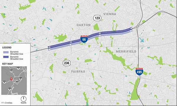
Source: Kittelson & Associates
Figure 43. Map. Dynamic part-time shoulder use in Virginia.
Once the threshold was reached and shoulder was opened, it stayed open for a minimum of 5 minutes before it could be closed.
VDOT coordinated with freeway service patrol, and operators in the TOC to make sure that the shoulder section was free of obstacles, and any debris before opening the shoulder for traffic. The operators looked at observed queues, and cameras to check the roadway conditions.
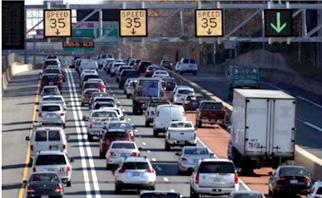
Figure 44 shows the shoulder open to traffic.
Criteria for Closing the Shoulder
The criteria for closing the shoulder were mainly traffic volume, and vehicle speeds, but traffic safety component was usually considered as well. The shoulder lane was closed for traffic if the traffic volume fell below 1,400 veh/h/ln, and speeds were greater than 55 mi/h. When a situation arose that seemed to compromise traffic safety, and during heavy snow days, or during holidays when HOV facilities were not open, the shoulder lane was closed for travel.
During special events and/or holidays, the operator based on his/her own discretion closed the shoulder for traffic.
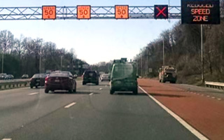
Figure 45 shows the shoulder being closed to traffic.
Other ATM Treatments Present
- Advisory variable speed limits (when shoulder is open for travel).
- Queue warning systems.
- Lane use control signs.
Impact Assessment/Results
Virginia Department of Transportation (VDOT) stated that the crash frequency on the dynamic shoulder use segment was reduced by 8 percent after its implementation. The rear-end crashes reduced by 13 percent and the injury crashes reduced by 6 percent. However, there is no significant change in the crash frequency along the entire corridor of I-66.
The crash modification factors (CMFs) for the D-PTSU segment all crashes are 0.75, 0.71, and 0.69 for total, multiple-vehicle, and rear-end crashes respectively. Similarly, the CMFs for the DSU segment fatal and injury crashes are 0.69, 0.59, and 0.61 for total fatal and injury, multiple-vehicle, and rear-end crashes respectively (Suliman, 2017).
Contact Information
Kamal Suliman
Regional Operations Director
Virginia Department of Transportation
Kamal.Suliman@vdot.virginia.gov
703-259-2231
References
Fontaine, M. (2016). Virginia DOT Experiences with Active Traffic Management on I-66. Virginia Transportation Research Council, Virginia.
Suliman, K. (2017). Part-time Shoulder Use VA-267, I-495, I-66. Retrieved from Virginia Department of Transportation, Part-time Shoulder TRB Webinar: http://onlinepubs.trb.org/onlinepubs/webinars/171012.pdf
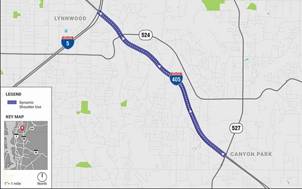
I-405 Freeway, Lynnwood, Washington
Name of the Facility
I-405
Operating Agency
Washington Department of Transportation (WSDOT).
Background
An existing right shoulder on I-405 was converted to dynamic shoulder lane that extends from SR 527 interchange in Bothell to the I-5 interchange in Lynnwood. This is the first implementation of dynamic part-time shoulder use (D-PTSU) in the State of Washington.
Length/Number of Lanes
This roadway section is 1.8 miles long and operates as a dynamic shoulder lane when extra capacity is needed. This roadway section maintains three (3) lanes (two regular and one express toll lane) plus the D-PTSU on the right.
The lane width for the dynamic shoulder lane is 13 feet. There is heavy traffic during the afternoon peak hour in the general purpose lanes that creates congestion south of SR 527 during the peak periods. A white solid line separates the travel lanes from the dynamic shoulder.
Figure 46 shows the map of the D-PTSU in Washington on I-405.
Source: Kittelson & Associates
Figure 46. Map. Dynamic part-time shoulder use in Washington.
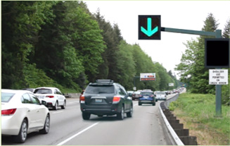
Source: WSDOT
Figure 47. Photo. Dynamic shoulder lane open.
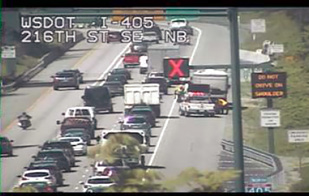
Source: WSDOT
Figure 48. Photo. Dynamic shoulder lane closed.
Date of Implementation/Status
April 24, 2017
Core Time Periods of Operation
Weekdays (Monday – Wednesday): 2 p.m.–7 p.m.
Weekdays (Thursday – Friday): 11 a.m.–7 p.m.
Criteria for Opening the Shoulder
The criteria for opening the shoulder is traffic volume. Roadway section with a traffic volume greater than or equal to 1,400–1,500 vehicles per hour per lane is used as threshold value for opening the shoulder. Historical volume information is used for making that decision.
Once the threshold is reached and shoulder is opened, it will stay open until 7 p.m., even if the traffic volume reduces a little before 7 p.m. During special events/occasions, the dynamic shoulder lane is open after 7 p.m. (i.e., when needed).
WSDOT coordinates with two maintenance officers (i.e., electronic maintenance and regular maintenance) to make sure that the shoulder section is free of obstacles, and any debris before opening the shoulder for traffic. Checks for clearance on the shoulder section are done by cameras and incident response team. After performing these checks, the dynamic shoulder lane is opened for traffic. However, WSDOT is planning for the process to become less manual and more automated.
Figure 47 shows the shoulder being open for traffic.
Criteria for Closing the Shoulder
WSDOT does not open and close the shoulder for shorter durations. Once a shoulder is opened, operators at the traffic operating center (TOC) wait until 7 p.m. or after 7 p.m. (if needed) to close the shoulder.
The shoulder is not opened with regularity during weekends or and holidays. However, the shoulder is opened during the weekend for special circumstances like crashes.
Figure 48 shows the shoulder being closed temporarily for traffic due to an obstacle on the shoulder.
Other ATM Treatments Present
- Electronic lane control signs.
- Side mounted message signs.
- Supplemental messages and queue warning systems.
Impact Assessment/Results
WSDOT is still optimizing the thresholds for opening and closing of dynamic shoulder section. WSDOT is collecting data and will perform opertational and safety studies when they have enough data to carry out the analysis.
In the first five months of dynamic shoulder operation, there were 11 incidents reported on the roadway section, of which four were crashes, 6 were disabled vehicles, and one was an unclassified incident. However, this data is not sufficient to identify trends in road safety performance.
Contact Information
Morgan Balogh
Traffic Engineer
Washington Department of Transportation
BaloghM@wsdot.wa.gov
206-440-4485
References
Hanson, B., and Westby, K. (2017). I-405 Peak-Use Shoulder Lane: Project Overview. NOCoE Webinar. Washington State Department of Transportation.
A 3, A 5 Freeways, Hessen, Germany
Name of the Facility
A 3, A 5
Operating Agency
Hessen.
Background
Due to the increase in the traffic congestion on motorways especially during peak hours, some federal states in Germany implemented dynamic part-time shoulder use (D-PTSU). This measure effectively increases the capacity of frequently congested freeway sections during peak hours.
Other federal states in Germany have also implemented D-PTSU, and the information is provided in the "D-PTSU in other Federal States" section below.
Length/Number of Lanes
The currently existing D-PTSU segments in Hessen State of Germany are a total of 57 miles long. These D-PTSU sections operate as a travel lane when extra capacity is needed.
The typical width of dynamic shoulder lanes is 11.5 ft, which is the minimum standard width of lanes that are used by heavy goods vehicle according to the German motorway design guidelines. The speed limit must not exceed 62 mi/h while the D-PTSU is in operation. The dynamic shoulder lanes are separated from the general-purpose lanes by a white solid line.
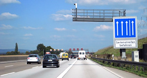
Source: Geistefeldt, 2012
Figure 49. Photo. Dynamic shoulder lane open.
Date of Implementation/Status
1996–2017
Core Time Periods of Operation
Based on the traffic patterns of each facility, typically during morning and/or afternoon peak hours.
Criteria for Opening the Shoulder
The main criterion for opening the shoulder is traffic volume on the roadway. The decision to open a shoulder is made by the operator at the traffic operation center (TOC), supported by the control system. The control system proposes to open the shoulder based on the defined parameters for traffic volume, sufficiently prior to the expected breakdown. The operator at the TOC relies on the movable cameras covering the entire section of the D-PTSU segment to make sure that the shoulder is free of obstacles and any debris before opening it for traffic.
Figure 49 shows a dynamic shoulder use segment being open for traffic.
Criteria for Closing the Shoulder
Similar to the criterion for opening the shoulder, the criterion for closing the shoulder is traffic volume. Once the traffic density is reduced, based on the operator's discretion, the shoulder will be closed for traffic. In case of accidents or broken-down vehicles, the shoulder is immediately closed by the operator.
Dynamic part-time shoulder use segments are not opened during heavy snow and extreme weather or road conditions when D-PTSU cannot be safely used. However, these situations are extremely rare in Germany.
Other ATM Treatments Present
- Lane control systems.
- Variable speed limits.
- Variable message signs.
- Movable cameras.
- Back of queue, incident, and weather warnings.
Impact Assessment/Results
A study conducted by the Traffic Centre Hessen reported that there is a 20–25 percent increase in the capacity of a three-lane carriageway, when the roadway segments before and after the implementation of dynamic shoulder use are compared in terms of operations (Geistefeldt, 2012). This permits traffic volumes of over 7,000 vehicles per hour without traffic breakdown.
In Hessen, internal analyses revealed that the dynamic shoulder use on Hessen motorways does not affect road safety. Through the research team questionnaire, Bavaria and North Rhine-Westphalia stated that there were no reported negative effects of hard shoulder use on road safety.
A safety study on motorway A3 in Hessen, and on A7 in Schleswig-Holstein concluded that the total crash rate on the main roadway section increased slightly, whereas the total crash rate of congestion-related crashes on the upstream segment tended to be lower after the implementation of D-PTSU (Jones, Knopp, Fitzpatrick, & et.al., 2011).
D-PTSU in Other Federal States
There are D-PTSU implementations on A 4, A 7, A 8, A 9, A 45, A 57, A 63, A 73, A 99 facilities in other federal states of Germany. These states include: Baden-Wuerttemberg, Bavaria, Lower Saxony, North-Rhine Westphalia, and Rhineland-Palatinate.
Contact Information
Dr. Justin Geistefeldt
Professor
Institute for Traffic Engineering and Management
Ruhr-University Bochum, Germany
justin.geistefeldt@rub.de
+49 234 32-25936
References
Geistefeldt, J. (2012). Operational Experience with Temporary Hard Shoulder Running in Germany. Transportation Research Record, Journal of the Transportation Research Board, No. 2278, Washington D.C., pp. 67–73.
Jones, J. C., Knopp, M. C., Fitzpatrick, K., & et. al. (2011). Freeway Geometric Design for Active Traffic Management in Europe. Washington D.C.: U.S. Department of Transortation, Federal Highway Administration.
Freeways, the Netherlands
Name of the Facility
A1, A2, A4, A7, A8, A9, A10, A12, A13, A15, A20, A27, A28, A50
Operating Agency
Rijkswaterstaat, Centre for Transport and Navigation.
Background
Due to the increase in the traffic congestion on roadways, the Centre for Transport and Navigation in The Netherlands implemented dynamic part-time shoulder use (D-PTSU) to resolve the traffic flow bottlenecks in the short term. There are two types of D-PTSU — right and left. Both act as dynamic shoulder lanes that are used as travel lanes during the peak periods of congestion.
Length/Number of Lanes
The existing dynamic shoulder lanes on the right comprise of 20 D-PTSU sections totaling a length of 100.66 miles of roadway segments. The existing dynamic shoulder lanes on the left comprise of 19 D-PTSU sections totaling a length of about 99.35 miles in total. These roadway sections operate as a dynamic shoulder lane on the right or left, when extra capacity is needed.
The dynamic part-time shoulder lanes on the right are separated from the general-purpose lanes by a white solid line. Similarly, the dynamic shoulder lanes on the left are separated from general-purpose lanes by a white dotted line that is different from the ones that separate the two general-purpose travel lanes.
Date of Implementation/Status
1999–2015 (D-PTSU segments are still being constructed and/or planned in 2017–18).
Core Time Periods of Operation
Based on the algorithm and varies from facility to facility.
Criteria for Opening the Shoulder
The criteria for opening the shoulder is traffic volume on the roadway. Vehicle speeds are not considered while making the decision to open a shoulder. If the traffic volume of a roadway exceeds 1,400–1,500 vehicles per hour per lane, then software triggers a warning for opening the shoulder. There is an option in the software that allows the agency to set a warning 15–20 minutes before the need to open the shoulder is predicted.
Rijkswaterstaat coordinates with the operator at the traffic operations center (TOC), who relies on video cameras covering the entire section of the roadway (i.e., the D-PTSU section) to make sure that the shoulder is free of obstacles and any debris before opening it for traffic.
Figure 50 and figure 51 show the shoulder on the right and left being open for traffic respectively.
Criteria for Closing the Shoulder
Similar to the criteria for opening the shoulder, the criteria for closing the shoulder is traffic volume. Once the traffic density is reduced, the software gives a warning to close the shoulder and the shoulder will be closed for traffic.
There are three types of facility operations: a) D-PTSU only used in the morning or evening peak hours, b) D-PTSU used both in the morning and evening peak hours, and c) D-PTSU that open in the morning, remain open all day, and close at night. The shoulder is closed in all these scenarios after the warning from the software, during incidents, or at the operator discretion.
Other ATM Treatments Present
- Variable message signs.
- Cameras.
- Automatic incident detection.
Source: © Tineke Dÿkstra Fotografie
Figure 50. Photo. Dynamic shoulder lane open on the right.
Source: © Justin Geistefeldt
Figure 51. Photo. Dynamic shoulder lane open on the left.
Impact Assessment/Results
A safety study was done in 2007, and the area of analysis included 1.24 miles upstream, and 0.62 miles downstream of the segment in addition to the D-PTSU section. After analyzing 14 dynamic shoulder lanes individually, the researchers concluded that the level of road safety on road sections with dynamic shoulder lanes increased (after the D-PTSU segment was open). In other words, the crash frequency reduced, and this may be attributed to the improved traffic flow on the roadway (Rijkswaterstaat, 2007).
This study stated that the implementation of D-PTSU resulted in a reduction in the number of congestion-related (i.e., rear-end) crashes during the peak periods. In addition, the number of fatalities decreased for 12 out of the 14 D-PTSU segments. One fatal crash was directly attributed to the presence of the dynamic shoulder lane.
Of the 14 D-PTSU sections, 8 were D-PTSU on the right, and 6 were D-PTSU on the left. For the dynamic shoulder lanes on the right, the rear-end crash frequency decreased when compared to the before period for 6 sections. However, for the dynamic shoulder lanes on the left, the crash frequency remained approximately the same when compared to the before period.
This finding is consistent with the recent safety study done in 2015, where the driving speed on the right shoulder is on average lower than on regular lanes, and on the left shoulder significantly higher than regular lanes, thereby increasing the crash frequency/risk in the left shoulder. However, the smaller or no merge/diverge conflicts on the left shoulder compared to the right shoulder decreases the risk of crash occurrence on the left shoulder (Drolenga, 2015).
Contact Information
Rudi Kraaijeveld
Senior Advisor
Rijkswaterstaat — Section Road Traffic & Utilisation
rudi.kraaijeveld@rws.nl
+31 6 15 879 686
References
Drolenga, J. (2015). Differentiatie Verkeersveiligheid Spitsstroken. Grontmij.
Rijkswaterstaat. (2007). Evaluation of the Effect of Rush-Hour Lanes on Road Safety. Center for Transport and Navigation.
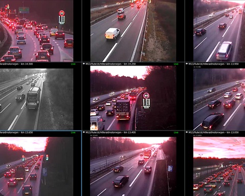
M13 Freeway, Copenhagen, Denmark
Name of the Facility
M13
Operating Agency
Vejdirektoratet, Danish Road Directorate
Background
Due to the increase in the traffic congestion on motorways, Danish Ministry of Transport implemented the first trial of dynamic part-time shoulder use (D-PTSU) in Denmark. This shoulder lane is part of a roadway section on Hillerod motorway between junction 8 and junction 6.
Length/Number of Lanes
This roadway section is 1.24 miles long and operates as a dynamic shoulder lane on the right, when extra capacity is needed, especially in the morning rush hour. This roadway section has two lanes in each direction of the road with an average annual daily traffic of approximately 66,000 veh/day.
Initially, a dotted line was used to separate the general purpose lane from the shoulder. Recently, this was replaced by a solid line.
Date of Implementation/Status
December 2013
Core Time Periods of Operation
Weekdays: 6:15 a.m. – 10 a.m. (+/- 10-15 minutes)
Weekends/holidays: not at all, or only for a couple of hours (if needed).
Criteria for Opening the Shoulder
The criteria for opening the shoulder is traffic volume and speed of vehicles on the roadway.
The decrease in speed from 68 mi/h to 59 mi/h is generally a good indicator for the shoulder to be opened. Danish Road Directorate generally operates the D-PTSU during the same time periods. Traffic congestion starts around 6:15 a.m. every morning during weekdays.
Hence the D-PTSU will be opened 5–10 minutes before that.
Danish Road Directorate coordinates with the operator at the traffic operations center (TOC), who rely on video cameras covering the entire section of the roadway to make sure that the shoulder section is free of obstacles and any debris before opening it for traffic.
The dynamic shoulder lane is not opened on weekends/holidays because of no or minimum traffic congestion. If there is a need, the HSR lane is opened only for a couple of hours.
Figure 52 shows the shoulder being open for traffic.
Criteria for Closing the Shoulder
Once the traffic congestion is cleared, the criteria for closing the shoulder are mainly traffic volume, vehicle speeds, but traffic safety component is usually considered as well.
Generally, the dynamic shoulder lane is closed after 10 a.m. when the traffic congestion ends on the roadway section. This operation is more variable in nature. The operator discretion is strongly considered while making the decision to close the shoulder for traffic.
Figure 2 shows the shoulder being monitored in the TOC by the operator.
Note: Algorithms are used as a decision support/ guideline. Danish Road Directorate have a list of policies and guidelines where they describe how to handle different situations.
Source: Danish Road Directorate (Vejdirektoratet)
Figure 52. Photo. Dynamic shoulder lane open.
Source: Danish Road Directorate (Vejdirektoratet)
Figure 53. Photo. Dynamic shoulder lane being monitored.
Other ATM Treatments Present
- Variable message signs.
- Pan-tilt-zoom (PTZ) cameras, fixed cameras with infrared lighting.
- Automatic incident detection.
Impact Assessment/Results
Before the D-PTSU was implemented, there were often 2.48 to 4.35-mile-long queues and the vehicle speeds were below 31 mi/h for about one and half hour every day.
The average travel time has reduced by 1–3 minutes on a 9.32-mile-long section from Allerod to Motorring 3, and 5 minutes towards junction 6 (7.45-mile section). The traffic volume on the motorway after the DSU was opened has increased by 18 percent, and much of the traffic has shifted from local roads onto the motorway (Danish Road Directorate, 2016).
However, the study findings also noted that the effects of traffic safety have not been analyzed yet, and so far there is no indication either on positive or negative effects.
Contact Information
Claus Lund Andersen
Project Manager Traffic Management Department
Vejdirektoratet, Danish Road Directorate
clla@vd.dk
+45 7244 3333
References
Danish Road Directorate. (2016). Evaluation Summary of Pilot Trial with Hard Shoulder Running on the Hillerod Motorway. Vejdirektoratet, Danish Road Directorate.
Freeways, South Korea
Name of the Facility
- Gyeongbu Expressway (Route 1).
- Seoul Belt/Ring Expressway (Route 100).
- Yeongdong Expressway (Route 50).
- Seohaean Expressway (Route 15, 50, 110).
- Namhae Expressway (Route 10, 102).
- Jungbu Naeryuk Expressway (Route 45).
- Jungang Expressway (Route 55).
A total of 7 highways and 26 sections.
Operating Agency
South Korea Expressway Corporation
Background
Due to the increase in traffic congestion on roadways especially during peak hours, South Korea implemented dynamic part-time shoulder use (D-PTSU).
Length/Number of Lanes
The D-PTSU segments are a total of 118 miles long in South Korea. The number of lanes varies across the facilities.
Date of Implementation/Status
2007
Core Time Periods of Operation
Based on the traffic patterns of each facility.
Criteria for Opening the Shoulder
The criteria for opening the shoulder is the vehicle speed on the roadway. In 2007, the shoulder was opened when the average traffic speed reached less than 43 mi/h and stayed at or below that speed for 15 minutes. However, in 2013, the criteria for average travel speed was changed to 37 mi/h.
The operator at the traffic operation center (TOC) relies on the cameras covering the entire section of the D-PTSU segment to make sure that the shoulder is free of obstacles and any debris before opening it for traffic.
Criteria for Closing the Shoulder
Similar to the criteria for opening the shoulder, the criteria for closing the shoulder is vehicle speeds. Once the traffic density is reduced, and the average travel speeds increase, the shoulder will be closed for traffic at the operator's discretion.
In other circumstances, such as a potential safety issue, the shoulder lane is immediately closed by the operator.
Other ATM Treatments Present
- Lane control systems.
- Variable message signs.
- Closed-circuit television (CCTV) cameras.
- Vehicle detective system.
- Emergency turnouts.
Impact Assessment/Results
No information available.