Freight and Land Use Travel Demand Evaluation: Final Report
Section 3
Topic B: Last-Mile Considerations
Consideration of the last-mile is a basic concern in the integration of land use and freight planning, particularly given:
Increased urbanization and mixing of land uses in most metropolitan areas.
A delivery paradigm shifting to more dispersed activity, including those professional goods and services delivered directly to residential addresses in lieu of brick-and-mortar retail sites and the innovative (but sometimes disruptive) technologies and markets that are growing to support that evolution.
Pressures to meet market expectations while managing potentially adverse community effects of greater freight traffic.
Topic B covers: 1) the significant gap in last-mile understanding; and 2) a last-mile analysis methodology ready to be adopted as a widespread practice.
Synthesis on Data Use and Application in Last-Mile Delivery Techniques
The growth of e-commerce and omni-channel fulfillment (which describes the process from the time a customer orders a product to the time the merchandise is delivered to that end-user through a combination of channels) has led to increased focus on the traffic impact of last mile deliveries. Last-mile deliveries present both challenges and opportunities for the private and public sectors, especially in terms of travel time and recurring/non-recurring costs. A public-private feedback loop appears to be developing wherein:
The public sector establishes policies affecting last-mile delivery at a site or at the neighborhood level. For example, policies might cover access and circulation design and operations, loading zone requirements, and curb space management.
The private sector adapts to the policies set by the public sector and tests the boundaries of optimum performance. Considerations that come into play include customer satisfaction and the costs to the company of violating the policies.
The public sector adjusts its policies in reaction to both commercial (e.g., business and tourism climates) and residential concerns (e.g., livability concerns raised by residents).
Such a feedback loop appears to be sustainable in terms of societal and technological perspectives. From the societal perspective, the high dollar value of last-mile efficiency is confirmed by statistics. From the technology perspective, pilot testing of automated delivery devices, from drop boxes to unmanned drones, is being developed on an iterative basis as communities explore regulatory changes to support an appropriate pace of innovation.
In a 2017 TRB paper (17-04295), Enabling the Freight Traffic Controller for Collaborative Multidrop Urban Logistics: Practical and Theoretical Challenges, Cherrett et al. suggest a collaborative "freight traffic control" paradigm that helps private companies share data and strategies that are either managed, or at least encouraged, by the public sector. The paper presents a case study of a proposed clustering and routing strategy for deliveries in central London. This case study demonstrates this strategy's potential for reduced costs and negative externalities, but also demonstrates the challenges associated with the decisionmaking process. While more data on urban deliveries and routing has vastly improved travel time and curb space management potential, many human factors considerations can affect the last-mile delivery process. These range from the degree to which clients make their schedules more malleable to account for variable "just-in-time" pickup to the degree with which local officials will enforce curb space management (or other innovative parking approaches).
The last-mile delivery topic is broad and under constant evolution, with sufficient nuances in definitional, societal, technological, and economic arenas to warrant an independent synthesis on last-mile delivery techniques. This synthesis could be developed through NCHRP to contribute to the QRFM update or developed independently by FHWA (and perhaps at a more cursory level) as part of QRFM. NCHRP 08-117, Impact of Transformational Technologies on Land Use and Transportation, will cover the impact of transformational technologies starting in 2018, including the retail last-mile element in its tentative work scope, and could also be a resource for this effort.
Transferable Last-Mile Analysis from Broward County
The SHRP2 C20 implementation assistance project in Broward County, Florida, focused on petroleum commodity flows. The Florida DOT District 4 assessed petroleum flow data to understand the supply and demand chain for petroleum commodities distributed from Port Everglades (PEV) to the 12 counties of southern Florida. A methodology was developed for estimating fuel consumption based on local factors such as land use, socioeconomic, roadway, and traffic inputs. The analysis also provided a viable solution to resolve the issue of "last-mile" petroleum information that is lacking in the current TRANSEARCH database.
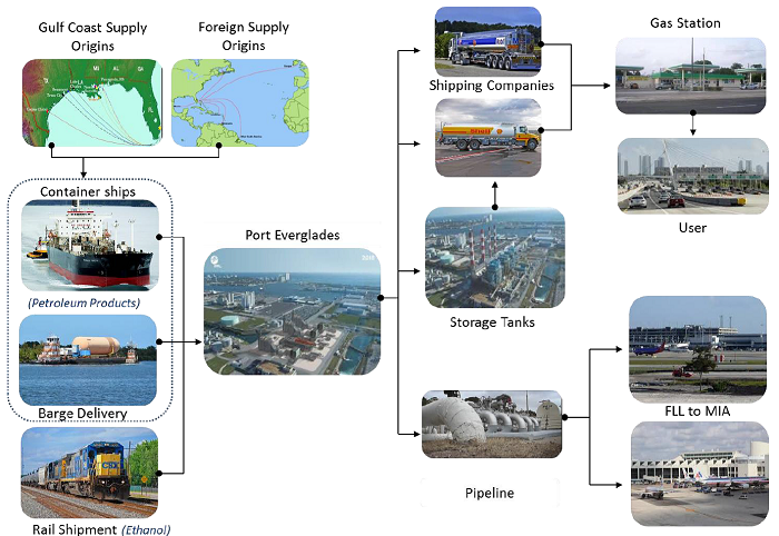
Figure 6: Summary of Southeast Florida Petroleum Commodity Flows
Source: SHRP2
The analysis first applied truck-GPS data from the American Transportation Research Institute (ATRI) to derive petroleum tankers' truck travel path (or route) information. Using a three-step approach, this data was used to describe the routes tanker trucks take from PEV to their final delivery points, including intermediate stops, as they distribute fuel to retail service stations:
- Identify petroleum tanker trucks originating at PEV.
- Derive the trip chains of trucks originating at PEV.
- Derive truck travel paths for the trucks traveling between PEV and gas stations.
To help close the gaps between TRANSEARCH database limitations and the tanker trucks that were not part of the ATRI instrumentation pilot, a methodology was developed to estimate the trip assignments and analyze the relationship between Broward County petroleum commodity consumption and available local data, including land use, socioeconomic, roadway, and traffic data (Figure 6). This approach, calibrated in part to the ATRI-instrumentation data, created a model to first predict fuel sales at retail locations based on gas station location, population and employment density, and household income (the four significant variables out of 23 variables tested). This information was used to predict fuel sales, which could then be used to estimate fuel deliveries and truck VMT. This approach, relying on sales volume rather than either retail facility size or employment, can be incorporated in QRFM update as part of a hybrid modeling process.