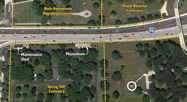
Use of Narrow Lanes and Narrow Shoulders on Freeways: A Primer on Experiences, Current Practice, and Implementation ConsiderationsChapter 3. Case Studies of Narrow Lanes and Narrow ShouldersSignificant widening of a freeway in an urban area is often impracticable due to the adjacent development and land use and physical constraints, often coupled with funding constraints. An additional lane may nevertheless be provided within the existing roadway footprint by reducing the widths of the existing lanes and/or shoulder, or using the shoulder as a part time travel lane. The use of narrow lanes to provide additional capacity and improve operations within the existing roadway footprint is not new. Brief case studies of this approach are provided below. Narrow Lanes as Part of Freeway Modernization along I-94 in Milwaukee, WisconsinThis Case Study illustrates how a Performance-Based Practical Design (PBPD) approach can be used to analyze and make trade-offs during the design of major freeway reconstruction in a constrained urban area — specifically, the reconstruction of I-94, the East-West freeway, in Milwaukee, WI, and the ultimate recommendation to incorporate narrow lanes and shoulders along a segment of the project. The I-94 East-West corridor study area is located in central Milwaukee County between the downtown Milwaukee Marquette Interchange and the Zoo Interchange. This portion of the I-94 East-West Freeway corridor is comprised of six lanes, three in each direction. It plays a key role in moving commuters, tourists, freight and other movements to major sites around and beyond the Southeast region of the state. As the corridor is nearing the end of its useful life, WisDOT initiated analyses to determine how the corridor should be rebuilt to ensure that it serves the economy of Southeastern Wisconsin for decades to come. The option of merely rebuilding the six-lane freeway was eliminated early in the process based on a DOT analysis showing the need for eight lanes to reduce congestion and accommodate future traffic growth. One segment, less than a mile in length, passes between a number of cemeteries as shown in Figure 8. As part of the screening process, two preferred alternatives were identified and scoped to avoid direct impacts to the adjacent cemeteries.
Analyses were conducted for the various scenarios for the design year 2040 conditions using the proposed geometric alternatives and projected traffic data. The results of the analyses relative to the system needs and objectives are summarized below.
WisDOT has identified the at-grade alternative, with narrow lanes, as the preferred alternative4 As noted in the WisDOT press release:
"The alternative selected provides the community with the best balance when all critical factors are evaluated together. We are recommending an approach which addresses the problems of crumbling infrastructure, congestion, and integration with the local street network. The at-grade alternative is the least expensive to construct and have lower potential for community and cultural resources impacts."
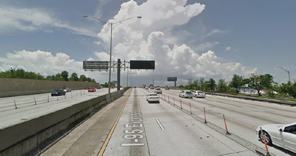
The 11-foot travel lanes and narrow shoulders through the cemetery area (with the At-Grade alternative) do not meet WisDOT and AASHTO criteria for the approximately 2,000-foot distance between the cemeteries and require design exceptions. The At-Grade Alternative also requires a design exception for inadequate sight distance in the cemetery area (that is, the slight curve on I-94 through the cemeteries, combined with the 2 foot shoulders, would cause the concrete median barrier to reduce sight distance). These design exceptions do not reach a level that makes proceeding with the project in light of the stated purpose and need unreasonable, nor do they result in unacceptable safety or operational problems. Moreover, potential safety concerns with the designs could be mitigated to some extent by the inclusion of Transportation System Management and Operations (TSMO) strategies such as ATM. In summary, this example illustrates how the use of narrow lanes and shoulders — identified and analyzed using a PBPD approach — can result in a feasible and cost-effective solution for upgrading an older urban freeway. Narrow Lanes to Accommodate Additional Managed Lane along I-95 in Miami-Dade, FloridaI-95 from I-395 in Downtown Miami to I-595 in Broward County was comprised of four general purpose lanes and a single High Occupancy Vehicle (HOV) lane, with the separation of the HOV and general purpose lanes via striping only. The HOV lanes had an occupancy requirement of 2+ during peak hours (7-9 AM and 4-6 PM). The HOV and general purpose lanes on I-95 were operating at LOS F during peak periods. Additionally, the violation rates on the HOV lane were very high, exceeding 30 percent in many segments. Florida DOT implemented a conversion of the facility — shown in Figure 9 — as follows:
A carpool registration component of I-95 Express was developed due to the right of way constraints that prohibited a dedicated declaration lane (for occupancy verification). The ability to leverage Florida Turnpike Enterprises electronic violation enforcement system also provided the Department with the opportunity to reduce the scope of Florida Highway Patrol (FHP) enforcement in the lanes. Current users of the HOT lane are three+ registered carpools and buses for free; with SunPass users allowed to use the lanes and pay a toll rate which is variable in relationship to the lane usage. The converted I-95 Express lanes have improved overall traffic conditions along the project corridor since its inception as shown in Table 6. In summary, this example illustrates how the use of narrow lanes and shoulders within an existing roadway footprint can help increase the capacity of managed lanes and improve the operation of both the managed lanes and general purpose lanes.
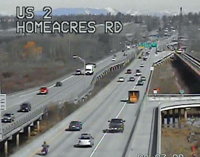
Narrow Lanes to Accommodate Part Time Shoulder Use on US 2 in Washington StateThis site is located on the US-2 eastbound Trestle between the I-5 and SR-204 interchanges (MP 0.66 to MP 2.22). This segment was re-striped from a configuration consisting of 4' left shoulder, two 12' general purpose lanes and a 10' right shoulder; to a 2' left shoulder, two 11' general purpose lanes, and a 14 foot auxiliary lane/shoulder on the right, as shown in previous Figure 1. A photograph of the current configuration is shown in Figure 10. The primary purposes for WSDOT to develop this static shoulder use were to reduce collisions in the I-5 / US-2 interchange and to keep traffic on the ramp from I-95 NB to US-2 from backing up onto the mainline of I-5 NB. The shoulder was first opened to traffic on April 6, 2009. The shoulder use operates in the PM peak period from 3:00 PM to 7:00 PM Monday through Friday. The shoulder is not open to traffic during all other time periods. The average speeds on the I-5 NB connector to US-2 EB have improved from 10 MPH to 37 MPH during the PM period of heaviest traffic.
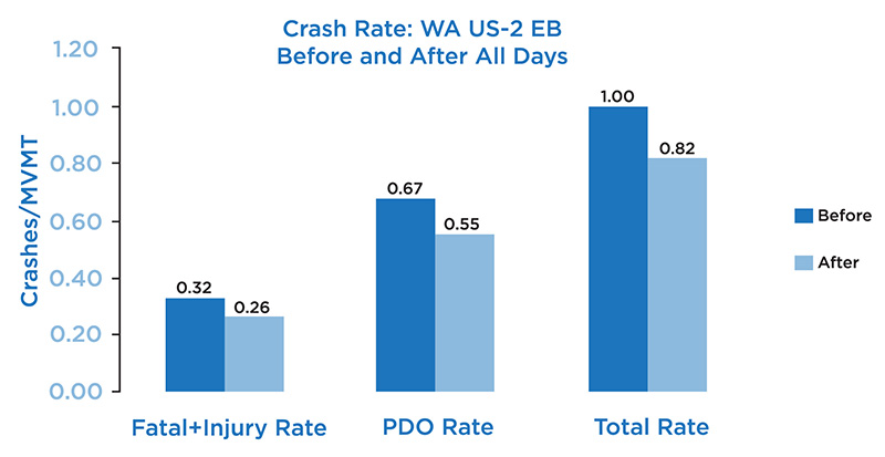
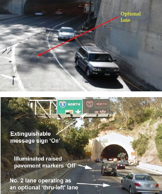
The capacity in the narrower general purpose lanes along US 2 is approximately 2,000 vphpl and the corresponding speed is approximately 50 mph. The capacity on the shoulder is approximately 1,400 vphpl and the corresponding speed is approximately 40 mph. When considered in terms of crash rates, since the shoulder was opened to traffic in the eastbound direction of US-2, the rate of crashes in terms of crashes per million vehicle miles traveled (crashes/MVMT) has decreased overall as shown in Figure 11. A significant finding from the analysis of the new lane configuration is that incident clearance times on US-2 during the PM peak (when shoulder use is allowed) are significantly longer than the PM peak clearance times before shoulder use was allowed — from approximately 20 minutes to 28 minutes for all incident types combined. This is an important consideration whenever shoulders are narrowed or when a full width shoulder is used by traffic. As previously noted, (TSMO) strategies such as enhanced incident management and dynamic lane assignment may help mitigate such concerns. In summary, this example illustrates how by narrowing travel lanes and one shoulder can help convert the other shoulder into a part-time travel lane, thereby improving operation of the facility, including reducing back-ups at an interchange. The reduction in congestion can also improve safety. Junction Control in Los Angeles, CaliforniaJunction control is an Active Traffic Management (ATM) strategy that dynamically allocates lane access on mainline and ramp lanes in interchange areas where high traffic volumes are present, and the relative demand on the mainline and ramps change throughout the day. For off-ramp locations, this may consist of assigning lanes dynamically either for through movements, shared through-exit movements, or exit-only. For on-ramp locations, this may involve a dynamic lane reduction on the mainline upstream of a high-volume entrance ramp and/or providing an additional lane for the on ramp. Volumes on the mainline lanes and ramps are continuously monitored, and lane access is dynamically changed based on the real-time and anticipated conditions. Implementing junction control may involve narrowing lanes, and/or part time use of the ramp and/or mainline shoulder thereby resulting in a narrow or no shoulder during junction control operation. A junction control system was installed in Los Angeles at the northbound State Route 110 connector to northbound I-5. The system required re-striping of the SR-110 mainline and the off ramp to provide a second ramp lane and an optional turn from the second mainline lane. The mainline and ramp lanes were not narrowed; but during junction control operation, there is minimal shoulder on the ramp. The project also included the installation of blank out signs allowing the lane adjacent to the exit-only lane to also be used as an exit lane (in addition to remaining a through lane) during peak periods. The new ramp configuration and signage are shown in Figure 12. Following implementation of this junction control system, the average ramp delay reduced from greater than 20 minutes to under five minutes, and the number of crashes decreased 30 percent from the previous year prior to installation as queued vehicles now are stopped towards the end of the slower moving ramp versus being stopped on the mainline of SR-110. In summary, this example illustrates how converting an off-ramp shoulder into a part time travel lane, and using Intelligent Transportation Systems (ITS) technologies to designate the appropriate freeway lane for both through and exit movements, can increase the capacity of an interchange during peak periods, thereby reducing ramp delay and improving safety. 4As of the writing of this Primer, the preferred alternative is still going through the final environmental impact statement process. | ||||||||||||||||||||
|
United States Department of Transportation - Federal Highway Administration |
||