Public Perception of Safety Messages and Public Service Announcements on Dynamic Message Signs in Rural Areas
Chapter 3. Traveler Intercept Survey Data Collection
This section presents background information about the data collection process and sites where survey work was conducted. Traveler intercept surveys were conducted at rest areas and truck stops to collect public feedback regarding safety messages and public service announcements (PSAs) posted by five agencies on dynamic message signs (DMS) in four study corridors.
Summary information is presented first, with additional details about survey work provided in separate sections below for each of the four study corridors listed below:
- Kansas: I-70 between Topeka and Salina (100 miles with 20 DMS).
- Minnesota and Wisconsin: I-94 between Madison, WI and Saint Paul, MN (250 miles with 14 DMS).
- Missouri: I-44 between St. Louis and the Oklahoma state line (280 miles with 31 DMS).
- Nevada: I-80 between Fernley and Wells (310 miles with 13 DMS).
Survey Preparations and Execution
This section describes the survey preparations employed in this project, including the coordination and feedback with each State department of transportation (DOT) point of contact to help the survey team identify survey locations. Lessons learned from the field, including anecdotal observations by the survey team and factors that may have influenced the survey are also presented.
Feedback received from State DOT representatives from each of the four study corridors, the Transportation Management Center Pooled-Fund Study (TMC PFS), and the Federal Highway Administration (FHWA) was used as the foundation for planning and preparations for conducting traveler intercept surveys. Information was gathered about how and when the State DOTs in the study corridors post safety messages, and a Survey Design and Execution Plan was developed to document how the surveys would be conducted. With some minor exceptions as noted below, the practices presented in the Survey Design and Execution Plan were followed in the field.
Battelle worked to coordinate travel to the four corridors to conduct surveys at times when a safety campaign was being conducted along the study corridors. Coordination with each State DOT point of contact was conducted prior to the site visit. These discussions helped the survey team determine the specific messages that would be posted on the DMS, when they would be posted, appropriate sites for conducting surveys, and also allowed the point of contact to review the corridor-specific questions that would be asked on the surveys. The survey questionnaires for each site are presented in Appendix A.
In the field, a two-person survey team was used to conduct surveys at all times, except for three days on the first survey collection trip in Nevada when a third survey team member was present. The survey team made concerted efforts to conduct surveys at times that would gather the most responses, using multiple locations for each corridor in the first round of surveys, and returning to locations that had the highest survey respondents for subsequent rounds of surveys. Several lessons learned from conducting surveys should be noted. First, while the survey team and iPad app-based instruments used in the field allowed for potentially high numbers of travelers to be surveyed, the generally rural nature and low traffic volumes of these corridors limited the number of survey participants. In anticipation of this, as well as other potential issues that could have arisen in the field, more survey days were added for each corridor beyond what had been initially planned, and additional site visits to collect surveys were necessary. Specifically, two days of surveying had been proposed for each corridor, but over 30 full days of surveying were necessary to collect the number that had been initially estimated for all corridors.
In addition, the initial intent of conducting surveys was to capture equal numbers of frequent travelers, infrequent travelers, and truckers. However, in the field it was quickly realized that, given low traffic volumes, it was necessary to intercept every traveler regardless of traveler type. Further, locations with higher percentages of frequent travelers or truckers, e.g., truck stops, resulted in fewer intercepts, and thus a much lower number of participants overall. Surveying more often at rest areas may have resulted in a higher number of infrequent travelers, but almost certainly resulted in similar or greater numbers of truckers and frequent travelers than would have been achieved at an off-interstate location (that would also include a mix of travelers not even on the interstate corridor). This approach also provided a higher number of survey participants overall.
A variety of safety campaign messages were posted on the four corridors while the surveys were being conducted in May, July, September, October, and November. Given the number of days required to conduct surveys in each corridor, and the limited periods of time that some States post safety messages on DMS, it was not always possible for the messages to be consistent for multiple visits within the corridor.
This study sought to understand the perceptions of three different types of travelers:
- Infrequent travelers (i.e., travelers that utilize the highway less than once per month).
- Frequent travelers (i.e., travelers that utilize the highway at least once per month).
- Commercial vehicle operators.
Overall, a total of 1936 travelers were surveyed across the 4 corridors, including 784 infrequent travelers (40 percent of responses), 623 frequent travelers (32 percent of responses), and 529 commercial vehicle operators (27 percent of responses).
The survey team logged estimated demographic information (male vs. female and three estimated age categories) as well as reasons that people declined to take the survey (eligible and refused, did not see the message sign, etc.). In addition, the survey team logged comments from survey participants regarding their opinion of messages they liked or recommended, and their general opinions of DMS, as presented in Appendix B.
Site Descriptions
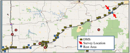
Kansas
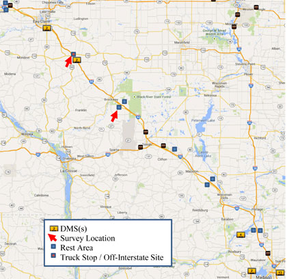
Surveys were conducted on the I-70 corridor in Kansas from July 6-9 and September 8-11 in 2015. Figure 3 is a map of the DMS locations along the I-70 study corridor in Kansas between Salina and Topeka, and the survey intercept locations, three at rest areas and one at an off-interstate location, a Petro Travel Center. Specifically, surveys were conducted at the westbound rest area near milepost 308 on July 6 in the afternoon and all day on July 7. On July 8, surveys were conducted at the eastbound rest area on the west end of the corridor in the morning and at the Petro Travel Center in Salina that afternoon. Surveys were conducted at the eastbound rest area near Paxico on the east end of the corridor on July 9 and all dates in September.
Minnesota/Wisconsin
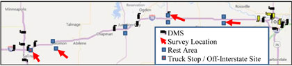
Surveys were conducted on the I-94 corridor in Minnesota and Wisconsin from May 26-28, September 15-17, and October 26-29 in 2015. Note that the I-94 study corridor is split between Minnesota and Wisconsin. The locations of the three Minnesota DOT-operated DMS in the I-94 study corridor are shown in Figure 4, along with the survey intercept location at the westbound Minnesota Welcome Center rest area. This location was used for most survey days in the corridor, given the higher survey participation rates, and evidence that travelers had also observed the DMS on the I-94 corridor through Wisconsin.
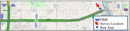
Figure 5 shows the ten current DMS locations on the I-94 study corridor in Wisconsin, and two survey intercept locations that were used on a single survey day, including a gas station at an off-interstate location in Osseo, Wisconsin and the eastbound Black River Falls rest area.
Note that for this survey corridor during the May 26-28 survey dates, an additional two questions about the use of portable changeable message signs (PCMSs) to display safety messages were added to the survey at the request of Wisconsin DOT. In conjunction with this request, the Wisconsin DOT placed additional PCMS in the field that displayed an abbreviated version of the safety message being displayed on the permanent DMS.
Missouri
Surveys were conducted on the I-44 corridor in Missouri from July 13-15, October 14-15, and November 2-5 in 2015. DMS on the I-44 study corridor are shown in Figure 6, and the survey intercept locations at the eastbound and westbound St. Clair rest areas. This corridor was particularly rural with few, if any, off-interstate locations that had significant traffic volumes. The survey team therefore conducted surveys only in the rest area locations, which had relatively high volumes because there are few rest area locations along the corridor.
Nevada
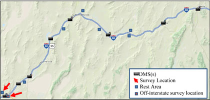
Surveys were conducted on the I-80 corridor near Fernley, Nevada from May 4-7 and October 5-7 in 2015. Figure 7 below shows the DMS locations in the I-80 study corridor, and the two survey intercept locations near Fernley, Nevada. The westbound Wadsworth Rest Area near Fernley was located immediately downstream of a DMS that was positioned in the median, and surveys were conducted here for most days. Surveys were also conducted one day at the Fernley Pilot Travel Center to increase survey participation from truckers. Alternative locations were considered elsewhere on the western portion of the corridor, but ultimately dismissed. Specifically, both a second off-interstate gas station location near Lovelock and the Trinity Rest Area at US 95 had minimal traffic. Rest areas near Winnemucca were considered as potential survey locations, however for unknown reasons the DMS were not displaying the safety messages as scheduled.