Planning for Transportation Systems Management and Operations Within Corridors: A Desk ReferenceChapter 3. Approach to Planning for Transportation Systems Management and Operations within CorridorsThis chapter provides information on several fundamental activities that will typically need to occur when planning for transportation systems management and operations (TSMO) on a corridor regardless of the type of corridor and the planning context. Chapter 4 describes the activities that are needed to make the plans for TSMO a reality through key activities, such as programming, design, and systems engineering. All of these activities form the basis for an approach to planning and preparing for the implementation of TSMO strategies in corridors. This approach is outlined in Figure 8. This figure will be used throughout the next two chapters to highlight the major activities. The approach is based on the planning for operations approach developed for advancing TSMO at the metropolitan planning level. Adaptations were made to account for the broad range of contexts in which TSMO may be planned for within corridors (e.g., planning for road weather management on a multistate corridor conducted outside of a formal regional or statewide planning process).
This section covers:
Getting Started - Scoping the Effort and Building a TeamDeveloping an effective corridor plan or system management plan requires scoping the effort and building a team of partners and stakeholders to work together on its development (Figure 9). Key questions to consider in scoping the effort include:
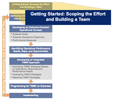 Figure 9. Diagram. The "Getting Started — Scoping the Effort and Building a Team" activity of the approach for planning for transportation systems management and operations within corridors.
The team involved in a corridor planning study provides a forum for idea sharing, decisionmaking, and a commitment to improving operations. Chapter 1 includes a preliminary list of transportation-related stakeholders that should be considered. Effectively engaging the team involves developing a shared understanding of the roles, responsibilities, and needs of key constituencies (e.g., partnering agencies, authorities, network owners and operators, stakeholders, and the users of the corridor). The team will then work together to define needs in the corridor, agree upon goals and objectives, develop preliminary consensus on pragmatic concepts for strategies or combinations of strategies that realistically address specified goals and objectives, and develop viable operating scenarios under which the concepts and strategies can be analyzed. Partner Agencies Working Together on the I-495 Corridor Concept of Operations in New York/New Jersey A wide array of partnering agencies in the New York/Northern New Jersey metropolitan region initiated a Concept of Operations study for the I-495 corridor, spanning from Northern New Jersey through the Lincoln Tunnel, Midtown Manhattan, the Queens- Midtown Tunnel, and I-495 through Queens. This complex corridor encompasses highways, principal and secondary arterial networks, bridges, tunnels, local street grids, and multiple transit services, and has engaged an extensive set of operating agencies and partners. In addition to primary partners, the agencies recognize the important role of emergency responders, private bus companies, event promoters, and the freight industry, among other stakeholders. Although there is no one-size-fits-all approach to team building, these approaches have worked for some regions:37
Benefits of CollaborationEnhancing collaboration and coordination among agencies involved in systems management and operations within corridors is a key component of integrated corridor management (ICM) and is vital to developing solutions for optimizing corridor performance; this is particularly true in complex urban corridors with many different operators and choices of modes and routes. Collaboration produces tangible benefits both to participating agencies and jurisdictions, as well as to system users and other stakeholders who depend on effective corridor operations in moving people and goods. These benefits fall into three general groups: (1) access to and use of existing resources, (2) improvements in current operations, and (3) better outcomes for system users and other stakeholders.39 Expanded Access to Resources and More Efficient Use of Existing ResourcesThe visible and immediate benefits of collaboration among agencies and jurisdictions in a corridor may be realized through strategies, such as:
Each of these approaches, or several in combination, can improve the use of available resources. Improved Agency OperationsBeyond more efficient access to and use of resources, collaboration enables cooperating entities to perform their missions more effectively. These improvements can result in:
Each of these, and other strategies, can enhance working relationships during routine operations and offer the added benefit of providing the foundation for preparing for and responding to emergency situations, crashes, intentional attacks on transportation assets or other infrastructure, planned special events (e.g., sporting events, conventions, and festivals), or major natural events (e.g., hurricanes, snowstorms, tornados, earthquakes, mudslides, wildfires, etc.). Better Outcomes or Results for Travelers, Suppliers or Shippers, and Other StakeholdersUltimately, system users and communities benefit through effects, such as:
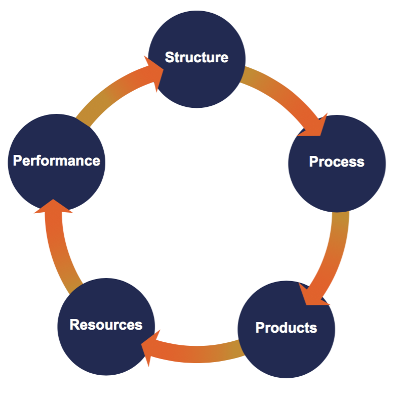
A Framework for Collaboration and Coordination in a CorridorFive key, or foundational, elements characterize the collaboration and coordination necessary for effective TSMO within corridors. As shown in Figure 10, these five elements are connected, interactive, iterative, and build upon foundational elements that can be applied at multiple scales. The starting point for collaboration and coordination is the structure, or the means through which individuals, agencies, and jurisdictions come together to identify needs, establish priorities, make commitments, allocate resources, and evaluate performance. In a corridor, a structure might be formalized in an ongoing corridor coalition or working group, or it may be addressed as part of broader regional or State efforts that include a focus on key corridors. The process is the course of action taken through which options are created and decisions are made; the process could involve formal activities like a structured set of meetings as part of a corridor planning process or informal activities. The products are the agreements, arrangements, and commitments to move forward with agreed upon strategies. The product may include a corridor plan, a concept of operations, operating plans and procedures, or other documents. Resources reflect the commitments made in terms of funding, people, equipment, facilities, support, and other assets needed to implement the strategies identified for the corridor. Finally, performance measurement provides the feedback to determine how well the agreed upon strategies have been implemented and executed, and the effect these strategies have had on outcomes of interest in the corridor relative to the agreed-upon goals and objectives. Connections to Broader Planning and Operations EffortsTransportation planning in a corridor should build off of broader planning efforts for TSMO, as well as existing operations programs and strategies at a regional and State level. Regardless of the size of the corridor, planning for corridor operations should recognize and build upon existing programs that can benefit the corridor, including:
In particular, transportation management centers (TMCs) use real-time information to support quicker incident management and communicate this information to the public through 511 systems, the Internet, and media to help travelers avoid delays. Employing active traffic management (ATM) and active transportation and demand management (ATDM) strategies in a corridor builds upon the foundation of monitoring, assessment, and response that takes place within TMCs. This may involve applying a wide range of strategies, such as opening shoulder lanes to transit vehicles or general-use traffic during congested periods, adjusting speed limits based on traffic levels, and dynamic ramp metering to control the flow of traffic at merging points. TDM program services and incentives also could be targeted to specific corridors, particularly those with major construction activity. For instance, in the Washington, DC, metro area, the Virginia DOT and Maryland State Highway Administration partnered in developing the Bridge Bucks pilot program, which provided a 50-dollars-a-month incentive to commuters who switched out of their cars and into buses, trains, or vanpools during reconstruction of the Woodrow Wilson Bridge. The regional Commuter Connections program, operated by the Metropolitan Washington Council of Governments, was a resource that helped provide ridematching and a guaranteed ride home to participants.40 In developing corridor goals, operations objectives, and performance measures, and identifying and selecting appropriate strategies for application, the approach for planning for TSMO on a corridor should build upon existing planning efforts that relate to system operations, including:
Effectively planning for TSMO within corridors will build upon existing plans and programs and ensure that corridor plans are compatible with, and take advantage of, these broader efforts. It is important to recognize that a corridor is part of a larger transportation network, and the policies and strategies being identified at the regional and state levels should help to inform the more geographically focused effort. At the same time, the plans, strategies, and operational relationships that will be effective within a corridor will reflect the specific travel needs, constraints, and opportunities of the corridor. Gathering Information on current and Future Context and ConditionsGathering information about the corridor — the current conditions and the future context — is a key early step in the development of any corridor plan or strategy (Figure 11). Data, both qualitative and quantitative, play a vital role in a performance-based approach to planning for TSMO in a corridor. 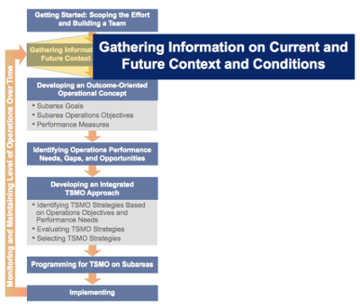 Figure 11. Diagram. The activity, "Gathering Information on Current and Future Contexts and Conditions," of the approach for planning for transportation systems management and operations within corridors. Baseline information helps define the existing conditions in the corridor, including identification of challenges and problem areas. Data on expected changes in population, land use, and travel conditions also will help to inform understanding of potential future corridor challenges that should be addressed during a corridor planning process. Data gathered during this phase also are a starting point for identifying opportunities for potential operations strategies that may be applied within the corridor and are used in analysis tools and evaluation to assess the effectiveness of these strategies. Given the critical role of data in a performance-based approach, gathering quality data and accurate information is imperative. Often, a technical advisory committee or some other type of stakeholder partner group will play a key role in defining corridor objectives and in providing guidance on data and information gathering. Members with operations data expertise will play an important role in bringing forth operations data to inform the corridor planning process, as well as to explain data limitations. Common sources of information include previous plans and studies; data sets on current and past system performance, including archived operations data; and forecasts of future conditions. Previous Studies, Reports, and PlansA review of existing studies, reports, and plans provides information about the broader planning context and may include recent multimodal transportation plans, pedestrian and bicycle plans, land use and development plans, and infrastructure condition reports. These documents offer insight into the long-term, big-picture vision for the corridor and surrounding study area. They also can provide data on anticipated future conditions in a corridor, such as population, jobs, housing units, and vehicle or passenger trips. A range of information may be available on the current transportation system components and features within the corridor study. For instance, topographical maps provide information about the corridor surface and geographical features. Documentation of the overall transportation network also is useful, including information about the existing multimodal transportation network, such as highways, transit services, and side and perpendicular streets (intersection types and traffic control measures used). Moreover, beyond the infrastructure, baseline information also should document existing operational assets, partnerships, relationships, and programs that affect system operations. Examples include ITS components, ramp metering, traveler information systems, incident management programs, and transit signal priority (TSP), among others. Documenting the current application of these system components or strategies will be important as a baseline for understanding the existing context in the corridor. Understanding Users of the CorridorUnderstanding travel markets and users of the corridor is important in defining both needs and possible strategies that will be effective. Some corridors carry significant freight truck activity, while others do not. Some also handle significant interstate through traffic, while others carry largely localized trips. While some freeway management and incident management strategies (e.g., variable speed limits and queue warning) will benefit all travelers and help system operators to have better information to adjust system operations, it is important to consider the needs of different types of travelers. Understanding the unique characteristics of travelers in the corridor and their key concerns also will be useful in assessing potential strategies that may be targeted to specific types of travelers. Recognizing how they access information and make travel decisions, some will aid in tailoring TSMO strategies. Possible traveler groups may include daily commuters traveling regularly to and from work or school, leisure travelers going to local destinations (e.g., running errands, entertainment, etc.), long-distance commuters or tourist travelers passing through, and freight or commerce vehicles transporting goods. Table 2 provides a sample of potential corridor users, their concerns, and TSMO strategies that planners and operators may consider to address those concerns. Table 2. Developing a thorough understanding of the corridor users will help determine possible transportation systems management and operations strategies.
Information on Current System PerformanceIn addition to information about the physical assets, corridor conditions, and traveler characteristics, data on current corridor performance are needed. Data on traffic volumes, peak hour volume, and travel patterns convey important information on corridor performance, and data may include average daily travel, peak-hour volume, and mode-split. Level of service (LOS), which is a function of traffic volumes, traffic composition, roadway geometry, and the traffic control at the intersection, is widely used in traffic studies and reports. However, LOS does not capture the source or extent of congestion, especially non-recurring congestion (due to traffic incidents, work zone, bad weather, special events, etc.). Better data on actual travel speeds and delay in a corridor can be critical to understanding existing conditions. To incorporate operations strategies into the corridor plan, a more detailed account of the causes and impacts of congestion along the corridor is needed. Archived operations data, from ITS programs, also can be used to assess important operational conditions, including system reliability; on-time transit performance; and the role of factors, such as weather conditions, on traffic congestion. Archived travel time data form the basis for understanding a wide variety of performance metrics, such as congestion, reliability, and freight mobility. Chapter 5, Toolbox for Effective Transportation Systems Management and Operations Planning, contains additional information on archived operations data. Safety data are very useful for identifying challenges and problem areas along the corridor that may be addressed by operations strategies. Types of safety data include incident data (e.g., fatalities, injuries, and property damage); crash data by type (e.g., rear-end, left-turn, etc.), weather conditions, and light condition (e.g., daylight, dusk, etc.); and the spatial distribution of crashes. Information about Future Conditions and ContextsInformation about anticipated conditions and contexts is important as well. This includes forecasted data about socio-economic factors (e.g., population, density, employment, etc.), as well as information from transportation modeling in regard to future anticipated travel demand. It also is important to document improvements slated for implementation in the near future. Information on future projects may come from consulting the metropolitan transportation improvement program (TIP), the statewide TIPs, or local plans. Stakeholder and Public EngagementQuestions to Gather Stakeholder Input Below are sample questions to facilitate a dialogue with stakeholders and the public to capture input about incorporating operations into corridor planning:
Source: Linking Planning and Operations Application, PlanWorks, Federal Highway Administration. Available at: https://fhwaapps.fhwa.dot.gov/planworks/. In addition to previous studies and information on current and future conditions, input from stakeholders and the public is critical; specifically, their opinions about the corridor and preferences for the future of the corridor. The public and stakeholders should play a key role in defining goals and objectives for the corridor, as well as the performance measures that will be used to assess system performance. In urban corridors, there often are tradeoffs to be made in terms of performance of the system in relation to passenger vehicles, public transit, bicycling, and walking, and the public and stakeholders should play a key role in defining the specific objectives for the corridor. The public, for instance, may be willing to accept lower average motor vehicle speeds to improve the safety and accessibility of pedestrian and bicycle activity. While optimizing system performance along urban and suburban highway corridors might involve diverting heavily congested freeway traffic to parallel arterials, there may be community concerns about the impacts on accessibility in neighborhoods, which need to be considered. Consequently, it is important to engage the public and stakeholders in clearly defining corridor goals and operations objectives and in articulating priorities and values. Methods for gathering information from stakeholders and the public include conducting qualitative research (e.g., interviews, focus groups, and workshops) or quantitative research (e.g., polls, surveys), as well as hosting citizens' panels and town hall meetings. A comprehensive approach should be used for stakeholder public engagement to capture input from all affected parties along the corridor, including those traditionally underserved by the existing transportation system (e.g., low-income communities, persons with disabilities, minorities). Engaging with stakeholders and the public early in the process is important and also presents an opportunity to raise awareness about operations and the role that operational strategies can play along the corridor. Educating stakeholders and the public about operational strategies will make them better-informed participants throughout the remainder of the corridor planning process. Once the information-gathering process is complete, there is solid understanding of the needs, deficiencies, and opportunities to address in the next step: developing an operational concept. Developing an Outcome-Oriented Operational ConceptAn effectively managed corridor involves not only the provision of highway and transit infrastructure for movement of people and freight, but also efficient ways of operating these systems to support mobility, reliability, and safety. Consequently, while corridor planning may involve consideration of, or focus on, certain types of infrastructure improvements (e.g., streetscaping, bicycle and pedestrian infrastructure), the planning process should focus on desired outcomes for travelers and communities, including outcomes related to how the corridor is managed and operated.  Figure 12. Diagram. The activity, "Developing an Outcome-Oriented Operational Concept," of the approach for planning for transportation systems management and operations within corridors. An outcome-oriented operational concept provides the framework for developing and evaluating options for the corridor that reflect local and regional values, which may include mobility, air quality, sustainability, livability, safety, security, economic activity, and accessibility, among other considerations (Figure 12). The relative priority of these considerations may vary depending on the context, needs of system users and other stakeholders, and stakeholder groups that are affected by transportation in the corridor. Examples of outcomes commonly used in corridor studies include safety and mobility, often defined in terms of levels of traffic congestion or hours of delay. Other outcomes may include economic vitality, community livability, environmental quality, and other community goals. Planning for TSMO involves considering a broad range of issues and outcomes associated with how transportation systems are managed and operated. For instance, a corridor plan with a greater focus on TSMO may include specific discussion of reliability as an outcome. In addition to general travel time, travelers and freight shippers often are very concerned about the variability in travel time from day-to-day or hour-to-hour. If it typically takes 20 minutes to travel a corridor off-peak and 30 minutes during peak congestion, travelers can plan for the extra travel time. However, if travel times are highly unpredictable, sometimes 30 minutes during rush hour but other times 60 minutes or more, this creates significant problems for making tightly scheduled appointments or delivery times. Studies show that travelers and freight shippers strongly value reliability in travel time; therefore, this is an important issue. High variability in travel times often is caused by traffic incidents, poor weather conditions, special events, and construction work zones, which can be considered in the context of corridors. Substantial experience in TSMO planning at the regional level shows that rather than just defining goals and strategies, a key foundation for advancing TSMO in planning is to define an outcome-oriented operational concept that brings together goals, measurable operations objectives, and performance measures that are focused on outcomes important to the transportation system users. In a regional context, use of operations objectives and performance measures supports consideration and selection of TSMO strategies for the long-range transportation plan and TIP.48 Similarly, corridor-based operations objectives and performance measures help to focus attention on system performance outcomes within a corridor and are a key element to support consideration of TSMO strategies. Developing an outcome-oriented operational concept is, by nature, an iterative process that involves developing an understanding of regional values that affect or influence priorities in the corridor and translating those priorities into observable and measurable outcomes that guide development of outcome-oriented objectives. The outcome-oriented operational concept describes, at a high level, how the corridor would operate to realize the desired outcome(s). The operational concept does not specify strategies to be implemented in the corridor. It will likely draw upon a collection of individual and complementary strategies in response to the operations objectives for the corridor and an assessment of the costs and benefits of each. In some corridors, ATDM concepts—active traffic management, active demand management, and active parking management—may prove to be attractive strategies; in others, other strategies that rely less on real-time data may prove effective (e.g., improvements in TIM, seamless integration of public transportation alternatives, and better integration of nonmotorized alternatives).49 These and other concepts can be incorporated into an overall operational concept for this corridor. The operational concept can be formalized within the framework of goals, objectives, and performance measures. The goals and objectives translate the values and priorities into statements that describe what is to be achieved with respect to transportation in the corridor that supports higher-level regional goals. The corridor goals should link to these high-level regional goals, and then lead to objectives expressed in measurable terms that can be used to help develop and evaluate strategies for achieving the objectives. Note that, in developing an outcome-oriented operational concept, specific solutions (strategies and tactics) are not considered, except to the extent that they may inform planners and operators about what is possible within available or anticipated technology solutions, legal and institutional arrangements, and fiscal constraints. Otherwise, the goals and objectives that characterize the operational concept should be open to new ideas about how to achieve the objective until after a range of feasible strategies and tactics is identified and evaluated using performance measures that relate directly to the objectives for the corridor. Operations GoalsOperations goals are the high-level statements of what transportation in the corridor would look like if it reflects the needs, values, and priorities of the key stakeholders and transportation providers that use, depend upon, or operate transportation facilities and services. For example, the goals for the Interstate-880 Corridor in the Oakland, California area, as developed by the ICM Oakland Pioneer Site Team, are:
Led by Dallas Area Rapid Transit (DART), the multi-agency ICM team for US-75 in Dallas, Texas developed a vision statement for the corridor and then four primary goals for the integrated management of the corridor. The team defined the vision as: "Operate the US-74 Corridor in a true multimodal, integrated, efficient, and safe fashion where the focus is on the transportation customer." This led the team to identify the following goals for the corridor:
Specific Outcome-based Operations ObjectivesThe high-level goals are the starting point for developing operations objectives, the basis for corridor TSMO planning. Operations objectives define desired outcomes for the corridor in relation to how the transportation system will perform. Operations objectives go beyond broad statements of goals, which often are loosely defined and difficult to assess. Operations objectives are specific, measurable statements developed in collaboration with a broad range of partners who have interests or who are affected by corridor transportation systems performance. They may be multijurisdictional in nature if the corridor of interest extends beyond or affects more than a single jurisdiction. Operations objectives generally lead directly to measures of performance that can be used to assess whether or not the objective has subsequently been achieved. Operations objectives should be specific, measurable, agreed-upon, realistic, and time-bound (SMART):
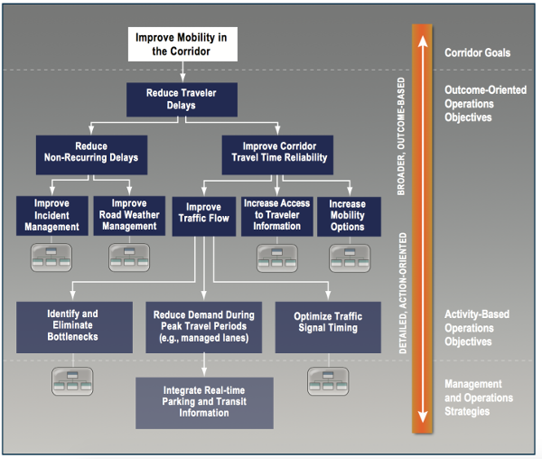
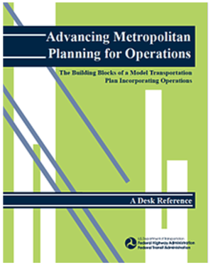 Figure 13. Image. Cover of Federal Highway Administration's Advancing Metropolitan Planning for Operations Desk Reference. Specifically, an operations objective identifies targets regarding a particular aspect of corridor performance, such as traffic congestion, travel time reliability, emergency response time, or incident response. By developing SMART operations objectives, system performance can be examined and monitored over time. Examples of operations objectives that may be applicable or could be adapted to corridor management and operations are provided in Federal Highway Administration's (FHWA) Advancing Metropolitan Planning for Operations: An Objectives-Driven, Performance-Based Approach — A Desk Reference (Figure 13).52 By including operations objectives that address system performance issues, such as recurring and non-recurring congestion, emergency response times, connectivity among modes, safety, and access to traveler information — rather than focusing primarily on system capacity — the planning effort for a corridor will elevate operations to play a more important role in investment planning, addressing both short- and long range needs. While outcome-oriented objectives are preferred because they are most closely related to the LOS provided to systems users, in some cases, outcomes are difficult to measure or observe directly. Corridor outcome-oriented objectives focused on outcomes to the user include corridor travel times, travel time reliability, and access to traveler information. The public cares about these measures, and in many regions, data may be available to develop specific outcome-based operations objectives. In cases where developing outcome-based objectives is difficult, agencies may develop corridor operations objectives that are activity-based and support desired system performance outcomes. For example, it may not be possible for a region to develop a specific objective related to incident-based delay experienced by travelers in the corridor if data are unavailable for this type of delay. However, it may be possible to develop an objective that relates to incident response time in the corridor, which may be more easily established and measured. Washington State Department of Transportation (WSDOT) US 195 Corridor Study — Spokane to the Idaho Border via Pullman — Clear Objectives and Data Analysis Lead to Innovative Lower-Cost Solutions The WSDOT led the Target Zero US 195 Corridor Crash Analysis planning study in the eastern part of the state to identify the most common circumstances or trends that contribute to serious or fatal injury crashes on this rural two-lane highway. The WSDOT used robust community engagement and a data-driven process to identify the key causes of fatal and injury crashes on the corridor. Initial stakeholder engagement found that the community strongly preferred expansion to a four-lane divided roadway. However, a four-lane facility, a very costly improvement, would not provide a practical solution and would not address the primary crash causes like distracted and drowsy driving, speeding, driving under the influence, and aggressive (inappropriate passing) driving. The WSDOT used a technical advisory committee composed of the regional transportation planning organization, cities, counties, universities, and law enforcement. The community was involved through a survey and various "listening posts," which were informal "meet and greets" at local gathering places like grocery stores, coffee shops, and post offices. Building on the crash data, the corridor study recommendations included a range of lower-cost operational and safety improvements, including enhanced intentional communication with travelers (e.g., variable message signs, brochures, public/private kiosks); improved striping; targeted maintenance to address real-time travel conditions; and enhanced emergency response, signage reflectivity, passing lanes, and geometric design to reduce the potential of severe and fatal crashes. For more information, see http://www.wsdot.wa.gov/Projects/US195/. Other examples of activity-based objectives include the percentage of traffic signals re-timed in the corridor, the number of variable message signs deployed, and the share of bus stops with real-time transit information. Although these objectives are not as ideal as outcome-based objectives because they tend to focus on specific strategies or approaches, they may serve as interim objectives until more outcome-based objectives can be established and measured. Working together to develop the objectives themselves may help to elevate management and operations discussions among planners and operators and lead to initiatives to collect additional data. One technique for organizing outcome-oriented and activity-based objectives is to develop an objectives tree that structures objectives in a hierarchical manner, with each top-level objective supported by lower-level subobjectives. The lower-level objectives, taken together, identify what must be achieved to realize the high-level objectives; the high-level objectives give the purpose for achieving the lower-level objectives. In many cases, the lower-level objectives will be activity-based objectives that relate to functions that must be performed to achieve high-level outcome-oriented objectives. Figure 14 illustrates how lower-level activity-based objectives support higher-level outcome-oriented bjectives, all acting in support of goals for the corridor or region.
Performance MeasuresOne of the key attributes of SMART objectives is that they are measurable. Performance measures are associated with operations objectives and provide a measurable basis for:
The idea that "what gets measured gets managed," recognizes that performance measurement focuses the attention of decisionmakers, planners, stakeholders, and the public on important characteristics of the transportation system. Developing performance measures involves considering:
It is important to recognize that there are often tradeoffs among different goals and objectives (e.g., traffic throughput, increasing transit ridership, and enhancing pedestrian and bicycle access); therefore, defining an appropriate and balanced set of performance measures for a corridor is important. Performance measures are indicators of how well the corridor transportation system is performing and are inextricably tied to operations objectives. A range of performance measures may come from developing operations objectives. The performance measures selected should provide adequate information to planners, operators, and decisionmakers on progress toward achieving their operations objectives. However, this is an iterative process as operations objectives may be refined once performance measures are developed and baseline data have been collected. Performance measures should be developed based on the individual needs and resources of each agency that provides services within the corridor. For example, transit agencies typically use a number of measures that are of interest to their customers, such as on-time performance, average passenger load, and total ridership. An MPO uses measures of mobility, such as facility LOS, travel time, and travel delay. These performance measures help planners focus on the day-today experience for their users. This provides important balance in settings where planners have focused exclusively on long-term development of the corridor. With greater focus on the day-today characteristics of the corridor, planners appreciate the issues faced by system operators. The result is that mid- and long-term planning now reflect greater consideration of operations and the associated investment needs within the corridor. Some examples of performance areas and performance measures likely to be associated with corridor operations objectives are shown in Table 3. These performance measures are primarily drawn from the FHWA's Advancing Metropolitan Planning for Operations: The Building Blocks of a Model Transportation Plan Incorporating Operations - A Desk Reference.53 Table 3. Illustrative performance measures to guide corridor transportation systems management and operations planning.
LOS = level of service. In summary, the performance measures (1) tie directly to the operations o bjectives, (2) provide the criteria for evaluating strategies and tactics for improving corridor performance, and (3) direct the gathering of data necessary to identify and prioritize needs and gaps. Identifying Operations Performance Needs, Gaps, and OpportunitiesGathering and analyzing data for performance measures is critical to identifying gaps between desired outcomes (objectives) and current conditions and in initially identifying potential opportunities for improvements (Figure 15). 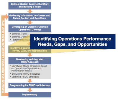 Figure 15. Diagram. The activity, "Identifying Operations Performance Needs, Gaps, and Opportunities," of the approach for planning for transportation systems management and operations within corridors. Often, a key step following the definition of performance measures is to define scenarios, or to conduct a scenario planning exercise as a basis for understanding current performance gaps and potential opportunities. Operational scenarios should be defined by stakeholders in the corridor and may include (but are not limited to):
By defining scenarios, the participants in the corridor often can identify existing gaps, performance needs, and potential opportunities for improvements. Moreover, discussions to identify gaps aid planners and operators in clarifying and documenting problems within the corridor and highlight opportunities for improving corridor performance. In many cases, performance data are available that clearly demonstrate where problems exist and need attention, investment, and priority in the planning process, and may be tied to specific types of situations or scenarios where performance improvements would be most important. Planners and operators must be cautious in depending on performance measures alone to identify gaps and opportunities, especially activity-based performance measures, because the performance measures may be specific to existing systems and may focus attention on improving existing operations strategies rather than considering alternatives that take advantage of new operational concepts, new technology, new institutional arrangements, and new or emerging user expectations. For example, if the performance measures suggest the need to reduce delay in the corridor by increasing average speeds, planners and operators may be tempted to focus on strategies such as adaptive signal controls and may overlook opportunities for transportation demand management approaches that increase use of shared vehicles (e.g., transit, carpools, and parking) or shift demand to other times and routes, making more effective use of available capacity. This does not mean that adaptive signal controls are inappropriate; only that performance measures, if not taken in context, can result in focusing on "efficiency" of current approaches rather than in how well outcome-oriented objectives are achieved. In the end, performance measures point toward deficiencies in achieving goals and objectives for the corridor and also can be helpful in identifying opportunities for improving corridor performance. Developing an Integrated Transportation Systems Management and Operations ApproachOnce the corridor TSMO planning team has agreed upon operations objectives for how the corridor should operate and identified the performance gaps, it can begin to identify a system of TSMO strategies that will be implemented on the corridor to reach the operations objectives. This system of TSMO strategies forms an integrated TSMO approach to improving performance on the corridor (Figure 16). It is important to consider TSMO strategies working together in the context of the corridor as opposed to selecting and implementing strategies in isolation. Planning for an integrated set of strategies allows planners and operators to leverage synergies between strategies. For example, the needs of first responders for managing traffic incidents should be considered when setting up work zones and, likewise, TIM plans may consider pre-positioning vehicles to support quick clearance in areas of reduced capacity due to work zones. Key Considerations in Developing an Integrated Transportation Systems Management and Operations Approach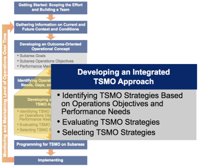 Figure 16. Diagram. The activity, "Developing an Integrated Transportation Systems Management and Operations Approach," of the approach for planning for transportation systems management and operations within corridors. Ensuring a System Solution Rather than "Stand Alone" ActivitiesThe traditional approach to transportation operations has traditionally involved individual agencies (State DOTs, local transportation agencies, toll authorities, transit service providers, etc.) managing their own assets and services (e.g., freeways, arterials, toll roads and bridges, and transit services). Yet, increasingly, a more effective and efficient approach is being used that involves a more holistic approach to managing operations on a corridor by viewing the corridor as a system, instead of a group of standalone assets. Under this approach, operators work together to make investments and real-time operations decisions to effectively shift travel demand across modes and routes to manage congestion, improve safety, and enhance system reliability. For instance, when a highway is severely congested due to a traffic incident, travelers may be directed to alternative routes, including parallel arterials, and traffic signal patterns may be adjusted to enable those arterials to better handle additional traffic. Moving Toward Active and Dynamic Transportation Systems ManagementThe use of operations strategies supports proactive and dynamic management of the transportation system, in which system performance is continuously assessed, and the system is managed through real-time implementation of adjustments (via traveler information, adjustments to signal timing, ramp metering, or other freeway operations) to achieve performance objectives (e.g., travel time reliability, corridor throughput, incident management). This approach requires collaboration, engaging partners to help influence travel choice and behavior along the corridor. Travel choice and behavior are influenced through active demand management (i.e., redistributing travel to less-congested routes or times of day and reducing overall trips by promoting mode choice); active traffic management (i.e., dynamically managing recurring and non-recurring congestion by improving travel throughput); and in urban areas, active parking management (i.e., optimizing the performance and utilization of available parking). Technology and innovation are critical to active and dynamic transportation systems management, supporting this data-driven approach implemented through information technology systems. Focusing on the Traveler, Rather than Just VehiclesA customer-focused perspective is the underpinning of an integrated approach to corridor management; rather than looking at enhancing vehicle throughput, a traveler-focused approach begins by examining traveler mobility needs and explores the most effective ways to meet those needs. This approach sets the context for developing a more efficient system for the end user. The TSMO approach is based on a fundamental understanding of how travelers decide which mode to use, what time to travel, which route to take, and at what time. Selecting operations strategies also requires segmentation of the travel market that differentiates between the various types of travelers (including commuters, non-commuter travelers, and freight movement), and understanding their travel behaviors, needs, and challenges to inform which operations strategies to implement. Considering Community Values and NeighborhoodsTransportation within corridors plays a key role in mobility, but is more than just moving people and goods. Transportation within corridors is a lifeline for communities, often linking neighborhoods, businesses, and jobs. The context of corridors should reflect the character and values of the surrounding community. Integrating operational strategies into corridor planning is not a uniform approach; the set of strategies selected for an individual corridor should be customized and tailored to respond to the unique issues, challenges, and opportunities present. Therefore, successful TSMO integration into the planning process requires engaging the partners (i.e., the various agencies that operate along the corridor), as well as community stakeholders and the general public. Recognizing Resource ConstraintsAlthough TSMO strategies are typically low cost, especially in comparison to expansion projects, a successful approach to implementing operational strategies is including them as part of an integrated approach within a broader project or plan. In many cases, lower-cost solutions can be implemented, or TSMO strategies can be implemented over time, in phases, to advance operations improvements in stages over time. When prioritizing TSMO strategies for deployment, benefitcost analysis, stakeholder and public input, and exploring the logical phasing of strategies are all useful analysis methods. Developing an Incremental Approach to Transportation Systems Management and OperationsTransportation agencies engage in TSMO activities at varying degrees of complexity. For some agencies, a basic traffic signal system meets the management needs of its transportation network, while other agencies rely on a set of advanced and integrated TSMO strategies to meet the mobility needs of the community. In either case, planning for TSMO allows agencies to advance operational strategies in a measured, organized fashion, whether in a single corridor or across a city or region. A key distinction in implementing TSMO strategies is that installation is just the starting point. Agencies must be prepared to expend the necessary resources to operate and maintain a collection of TSMO investments. The most effective TSMO activities are differentiated not by budgets or technical skills alone, but by the existence of critical processes and institutional arrangements tailored to the unique features of TSMO applications. Applying an incremental approach to TSMO strategies in a corridor is a clearer path to successful implementation by allowing time to both gain experience with the strategy and institute operational processes. The sections below describe the main activities necessary for developing an integrated TSMO approach to TSMO on a corridor. One of the current areas of research is in analytical tools that support consideration of multiple TSMO strategies and is expected to provide more support in the future to developing an integrated TSMO approach. Currently, there are limited options for quantitatively examining the impacts of one TSMO strategy on another. Identifying Transportation Systems Management and Operations Strategies Based on Operations Objectives and Performance NeedsThere are a variety of ways to identify TSMO strategies that could be implemented to address causes of the shortfalls in performance or gaps. This section provides examples of methods or tools for identifying TSMO strategies based on operations objectives and performance needs in a corridor. While the FHWA has developed some basic mappings between goals or objectives and TSMO-related strategies, this also has occurred at the State and regional levels as well, as practitioners look to match strategies to needs within a specific context.
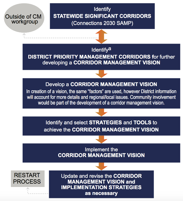
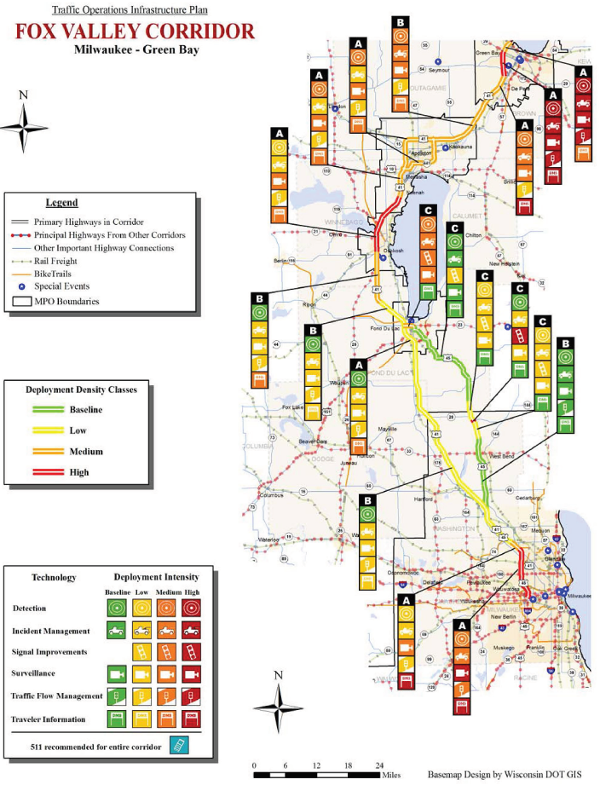
The Wisconsin DOT developed a Traffic Operations Infrastructure Plan in 2008 that offers a methodology that begins with identifying significant corridors based on their strategic objectives, and then determines priority management corridors for which they develop a corridor management vision.54 This process, illustrated in Figure 17, leads to selecting TSMO strategies that achieve the corridor management vision. The approach results in a deployment density for TSMO strategies, such as is illustrated for the Milwaukee-Green Bay corridor in Figure 18. Note that the higher densities of TSMO deployment are concentrated in the most urbanized areas where traffic densities also are the greatest. WisDOT used this plan to strategically deploy ITS across the state. As WisDOT's TSMO program has evolved, the TOIP has been replaced it with a TMSO-Traffic Infrastructure Process, which is an deployment process that considers needs and solutions on an annual basis and uses a needs analysis and cost benefit tool.55 The FHWA's 2015 Active Traffic Management Feasibility and Screening Guide provides additional guidance in the form of a series of logic flowcharts that assist in determining the appropriateness of specific ATM strategies given well-defined mobility issues to be addresses by the TSMO strategies.56 This document also describes methods for identifying and determining the capital investments required and expected operation and maintenance costs associated with various ATM strategies. Benefits are more difficult to predict, but the ATM Feasibility Guide suggests estimating benefits based on the experience of other locations where similar strategies were implemented in response to similar needs and objectives. In addition, the ATM Feasibility Guide suggests using the FHWA's Tool for Operations Benefit Cost Analysis (TOPS-BC) tool, a spreadsheet-based tool designed to assist practitioners in conducting benefit-cost analysis of operations strategies by providing four key capabilities, including:57
In 2010, the FHWA took a qualitative approach to matching operations objectives to potential TSMO strategies through the development of the Fact Sheets in Advancing Metropolitan Planning for Operations: The Building Blocks of a Model Transportation Plan Incorporating Operations - A Desk Reference.58 Samples of these Fact Sheets tailored to corridors are at the end of this chapter. The Fact Sheets contain operations objectives that are SMART and can be tailored to an area, time period, mode or facility type, or user type. The Fact Sheets also identify TSMO strategies that could help realize the operations objectives. This is meant as a tool to assist planners and operators in generating ideas for TSMO strategies to support specific objectives. The Fact Sheets were not tailored for the specific operations context that each locality may encounter. The current version of Turbo Architecture software, which is used to document regional ITS architectures, includes a "Planning" module that allows users to select operations objectives from the Fact Sheets or add custom objectives and link each of those to applicable service packages (essentially TSMO strategies) and performance measures.59 The Turbo Architecture "Planning" module can be used to help identify TSMO strategies for corridors. Regional ITS or TSMO plans commonly include a toolbox of TSMO strategies to support the identification of TSMO strategies for use. For example, the regional TSMO plan for the Portland, Oregon, region includes a TSMO Toolbox of Strategies organized by operational areas (e.g., arterials, freeways, and freight). Each strategy includes a description, example applications, potential benefits, estimated costs, and influencing factors (e.g., political, institutional, and technical).60 The Southwestern Pennsylvania Commission supports TSMO strategy identification in its congestion management process by rating corridors within the region against 25 strategies within their congestion management toolbox.61 The strategies seek to improve demand management, modal options, transportation operations, and capacity. Each strategy is evaluated based on its suitability, reflecting ease of implementation, and applicability to a corridor. Each strategy also is given a benefit rating based on how significant its impact may be on reducing congestion. The ratings are used to categorize strategies into high, medium, and low priorities. Several tools for screening TSMO strategies related to ATM are currently under development. The FHWA Active Traffic Management Feasibility and Screening Guide uses regional goals and associated issues and considerations to rate each potential TSMO strategy as offering a major improvement, some improvement, or neutral or not applicable.62 Caltrans, District 7 developed an ATM assessment framework that can be applied to any freeway corridor in the state. The framework describes potential ATM strategies with associated costs and benefits, which will address deficiencies (e.g., safety/crashes, non-recurring congestion, recurring congestion) observed in a particular corridor. This tool will support District 7's implementation of an innovative corridor management approach to managing and optimizing performance on the freeway system.63Sample Table for Identifying Transportation Systems Management and Operations Strategies for CorridorsTable 4 provides an example of TSMO strategies to consider based on operations objectives and performance gaps. This table focuses on objectives and strategies for an urban arterial that experiences recurring congestion. The desired outcome for improving corridor operations is the reduction of recurring congestion along the corridor. The middle column, "Performance Gap," documents the corridor's shortfalls in achieving any of the corridor's operations objectives. The last column, "TSMO Strategies to Consider," identifies potential TSMO strategies to address the deficiency or gap. To help ensure that an identified TSMO strategy will address the performance gap, the strategy should go through some type of screening and evaluation. The next section describes several options for doing this. Table 4. Example transportation systems management and operations strategy identification for a desired outcome of reducing recurring congestion on arterials.
Evaluating Transportation Systems Management and Operations StrategiesWhile many operations strategies (e.g., variable speed limits, queue warning systems, and dynamic ramp metering) have benefits, because they differ from conventional capacity investments in terms of cost, service life, and requirements, it is not always clear how to assess strategies. After identifying potential TSMO strategies for a corridor, there are several methods that are available to evaluate the strategies to determine which ones are most suitable to the corridor context and work together to provide the most benefit. This often takes place in two phases: screening the strategies for feasibility, and then conducting a more detailed evaluation prior to selecting strategies to move forward with funding and implementation. The evaluation factors may include technical and institutional feasibility, return on investment, or others relevant to the corridor stakeholders. Numerous methods and tools are currently available to evaluate TSMO strategies as part of corridor planning. They vary in purpose served, complexity, input and output data, and the strategies that they analyze. Four main categories of analysis tools could apply to the evaluation of TSMO strategies: (1) travel demand models; (2) sketch-planning tools; (3) analytical/deterministic tools; and (4) simulation models, as well as many hybrid approaches. Sketch-planning tools allow for the basic screening of strategies, while deterministic tools and simulation typically go beyond the results of travel demand models to enable more detailed analysis of TSMO strategies. When selecting a tool, it is important to not only match the tool's capabilities to the corridor team's objectives, but also to consider other factors (e.g., budget, schedule, and resource requirements). The team should avoid trying to apply a tool that is more complex and time-consuming than needed. Conversely, the team should not use a tool that lacks the sensitivity or detail to address its need. Travel demand models are useful in screening and evaluating corridor-wide strategies, such as congestion pricing and ridesharing programs, because they support an assessing mode choice and travel pattern or volume impacts. Travel demand models supply data to simulation models, sketch-planning tools, and post-processors that can analyze TSMO strategies. They are useful for generating traffic origin-destination patterns or volumes for input into simulation models. They are limited in their ability to analyze TSMO strategies, however, as they miss the impacts of incidents, work zones, and special events. Sketch-planning tools are intended to provide quick analysis using generally available information and data. They provide a quick order-of-magnitude estimate with minimal input data in support of preliminary screening assessments. Sketch-planning tools are appropriate early on when prioritizing large numbers of strategies or investments for more detailed evaluation. They are typically spreadsheets or simple databases that are based on built-in assumptions of impacts and benefits for various strategies. The FHWA developed the TOPS-BC, a benefit-cost analysis sketch-planning tool that is available to help corridor teams screen multiple TSMO strategies. It provides order-of-magnitude benefit cost estimates using default parameters that can be customized using local data. The TOPS-BC is available for download from the FHWA Planning for Operations Website.64 The FHWA is continuing to develop products to assist practitioners in applying benefit-cost analysis for TSMO strategies. Analytical or deterministic tools typically implement the procedures of the Highway Capacity Manual.65 These tools quickly predict capacity, density, speed, delay, and queuing on a variety of transportation facilities and are validated with field data, laboratory test beds, or small-scale experiments. The primary example of a tool within this category is the Highway Capacity Software, which implements the procedures defined in the Highway Capacity Manual for analyzing capacity and determining LOS for signalized and unsignalized intersections, urban streets, freeways, weaving areas, ramp junctions, multilane highways, two-lane highways, and transit. These tools have somewhat-limited application for evaluating TSMO strategies for a corridor. They are mainly for individual intersections or small-scale facilities and are widely accepted for examining different types of traffic control strategies (e.g., uncontrolled, stop controlled, and signalized). Simulation tools cover a range of software that is available to model transportation system operations and can be applied specifically to corridors. Simulation models are typically classified according to the level of detail at which they represent the traffic stream. Macroscopic simulation models simulate traffic flow, taking into consideration aggregate traffic stream characteristics (i.e., speed, flow, and density) and their relationships. Microscopic simulation models simulate the characteristics and interactions of individual vehicles. Mesoscopic simulation models simulate individual vehicles, but describe their activities and interactions based on aggregate (macroscopic) relationships. Agencies use simulation tools to analyze operations of both traffic and transit to conduct needs assessments, alternatives analysis, and environmental impact studies. A key advantage of these tools is their ability to simulate conditions, such as incidents, and analyze conditions under multiple scenarios. Some specific strategies that can be simulated include ramp metering, express lanes, and variable speeds limits. Most simulation models also produce graphical or animated displays of the results. These can be invaluable in presenting key findings and results to a broad range of audiences beyond transportation professionals. The primary challenges associated with simulation tools are related to the resources required to develop and apply such models. These include the level of expertise needed, data and computing requirements, and the amount of time required to adequately and accurately calibrate models to real-world conditions. Activity-based models are increasingly being used as a region's travel demand model and may be useful in evaluating TSMO strategies within corridors. They typically function at the level of individual traveler and represent how the person travels across the entire day. They provide detailed performance metrics but take much longer to run and have greater development and maintenance costs. They can evaluate pricing strategies, transportation demand management programs, and many other TSMO strategies. Dynamic traffic assignment (DTA) also is emerging as a practical tool for numerous planning and operations applications. DTA is a type of modeling tool that combines network assignment models, used primarily in conjunction with travel demand forecasting procedures for planning applications, with traffic simulation models, used primarily for traffic operational studies. DTA involves the capability to assign or re-assign vehicle trip paths based on prevailing conditions. For example, a vehicle may be re-assigned to a different path in the middle of its trip due to the congestion on its original path. DTA enables evaluating operational strategies that are likely to induce a temporal or spatial pattern shift of traffic. It enables estimating travel behavior from various demand and supply changes and interactions. It is suitable for analyses involving incidents, construction zones, ATDM strategies, ICM strategies, ITS, managed lanes, congestion pricing, and other TSMO strategies. However, the application of DTA does generally require a significant investment of resources and expertise in both demand and simulation modeling. Selecting Strategies to Best Achieve ObjectivesBuilding on the assessment of potential strategies using analysis tools, the corridor plan will involve selecting a set of promising strategies to achieve the operations objectives for the corridor. Given the wide array of potential strategies to consider, including those that focus on highway/ traffic operations, transit operations, demand management, and capacity, selecting strategies for a corridor often will involve both quantitative analysis, as well as qualitative assessments of what would work best to fit within the specific context of the corridor. It is important to recognize that effective corridor management will typically involve implementation of a number of complementary strategies, rather than a single strategy, or even a set of strategies applied to different modes. One of the key values of exploring corridor operations is recognizing the interconnections between different roadway facilities, transit, and other modal options. Consequently, a number of individual strategies may be grouped together and considered as a package of improvements. For instance, improving arterial operations may involve a combination of traffic signal coordination, TSP, and parking management strategies. Typically, planners and operators will work together to identify and evaluate potential strategies, and then define a package or several possible packages of improvements. The alternative corridor strategies can then be evaluated in relation to their performance in relation to defined operations objectives, within the context of community values, and with recognition of available resources for implementation. Some strategies also may not require investments in infrastructure or technology deployment in the field, but could be fostered through improved data sharing and communications practices. Prioritizing strategies or packages of strategies for selection often involves making tradeoffs in deciding what approach would be most effective to meet corridor objectives. For instance, use of a highway shoulder as a lane for buses could help improve transit reliability, but it needs to be considered in the context of road safety and the potential benefit for travelers in relation to the costs of upgrading the shoulder and lane markings, in comparison to other potential strategies. Similarly, on an urban arterial, traffic signal improvements, including retiming or TSP, need to consider an array of issues and potential impacts, including effects on road traffic, transit, and bicycles and pedestrians in terms of travel time and safety. To the extent possible, using common evaluation methods for comparative assessments of strategy alternatives is valuable. For instance, if travel time reliability (i.e., consistent or predictable travel times and on-time transit performance) is a key objective for the corridor, then integrating reliability performance measures into the selection of strategies can help ensure that strategies are prioritized that best support the TSMO objectives for the corridor. TSMO strategies that improve reliability include a wide range of strategies: information systems, incident management, managed lanes, TSP, and transit and freight vehicle tracking. As a result, using reliability performance measures does not define a singular strategy but is helpful in comparing the estimating impacts of different strategies. In addition to using the outputs of tools described above, approaches that can be used to compare strategies or packages of strategies include:
Commonly, the process of analyzing and selecting potential strategies or combinations of strategies will yield some approaches that are most promising. Putting it All TogetherAs described above, operations objectives are essential elements of TSMO planning. The following section provides a set of easy-to-use reference sheets for operations objectives that are relevant to corridors. Each reference sheet provides an overview of the operations objective area, a menu of operations objective statements and associated performance measures, a description of data needs and potential providers, and possible TSMO strategies to achieve the operations objective. They are intended as a resource for corridor TSMO planning teams who are searching for ideas for operations objectives and related TSMO strategies. The quick reference sheets draw from the FHWA's Advancing Metropolitan Planning for Operations: The Building Blocks of a Model Transportation Plan Incorporating Operations — A Desk Reference, and were adapted for application to corridor planning.67 System Efficiency: Corridor Travel TimeThe objectives focus on reducing the amount of time it takes to travel through a corridor. Travel time is a measure of the average time spent in travel, which is a function of both travel speed and distance. The objectives can be made multimodal to account for transit, truck, and bicycle travel in the corridor, where appropriate. Stakeholders
Goals
Corridor Operations Objectives
Performance Measures
Anticipated Data Needs
Data Resources and Partners State DOTs, counties, cities, traffic management centers, and private sector sources can provide travel time data including speeds and volumes. Transit agencies can provide transit travel time, speed data, and passenger counts. TSMO Strategies to Consider Strategies designed to reduce recurring peak period congestion, such as traffic signal coordination, and transportation demand strategies that encourage shifts in travel mode, time, or route. If the objective includes transit or bicycles, strategies can include transit signal priority or bicycle traffic signals. System Reliability: Non-Recurring Delay in CorridorsThis set of objectives is focused on minimizing non-recurring delay in corridors. This type of travel-time delay is caused by transient events as opposed to delay caused by geometric limitations or a lack of capacity. These objectives focus on non-recurring delay due to scheduled and unscheduled disruptions to travel. Stakeholders
Goals
Corridor Operations Objectives
Performance Measures
Anticipated Data Needs
Data Resources and Partners Travel time data during non-recurring events may be difficult to collect, particularly during unscheduled events, such as incidents and severe weather. Transportation management centers and/or public safety organizations are likely needed to assist in identifying the locations and times of traffic incidents. Road and track maintenance staff will be needed to identify upcoming work. Data on travel times during unscheduled events may need to be extracted after collection from ongoing travel time data based on the time and location of events. The National Weather Service also may need to be involved in identifying times and locations of severe weather that may have impacted travel. TSMO Strategies to Consider Strategies to reduce non-recurring delay include those that focus on reducing the delay caused by incidents, work zones, special events, weather, and other non-recurring events that affect traffic flow. System Options: Bicycle and Pedestrian Accessibility and EfficiencyThe objectives focus on improving the accessibility and efficiency of bicycle and pedestrian modes to offer travelers feasible and attractive travel options within a corridor. Stakeholders
Goals
Corridor Operations Objectives
Performance Measures
Anticipated Data Needs
Data Resources and Partners State and local DOTs, MPOs, counties, cities, highway districts, and universities are sources for pedestrian and bicycle travel data. Private-sector crowd sourcing data also can be utilized to inventory conditions and comfort level. Pedestrian and bicycle advocacy groups can be a source of data. TSMO Strategies to Consider Pedestrian countdown signals, bicycle lanes, wayfinding signage, and crossing signals where bicycles cross major roadways. Arterial Management: Traffic Signal ManagementThe objectives focus on improving the management of traffic signal operations in an arterial corridor through advanced technology, increased reviews, and planning. Stakeholders
Goals
Corridor Operations Objectives
Performance Measures
Anticipated Data Needs
Data Resources and Partners Partner agencies that operate arterials and agencies that maintain traffic crash records.TSMO Strategies to Consider Regular evaluation of corridor traffic signal timing, enhanced traffic signal systems, special corridor timing plans for events, incidents, and work zones, and regular review of corridor crash data.Freeway Management: Ramp ManagementThe objectives focus on the application of traffic control devices, such as ramp meters, signing, and gates, to regulate the number of vehicles entering or leaving the freeway to achieve operations objectives. Stakeholders
Goals
Corridor Operations Objectives
Performance Measures
Anticipated Data Needs
Data Resources and Partners Providers of travel data, including traffic volumes and incidents, such as State DOTs, cities, counties, and transportation management centers. TSMO Strategies to Consider Ramp management strategies typically encompass ramp metering, ramp closure, special use treatments (e.g., High-Occupancy Vehicle (HOV), special events), and ramp terminal treatments. Transit Operations and Management: Transit Signal PriorityThe objectives focus on implementing TSP systems to improve transit performance and reliability within a corridor. Stakeholders
Goals
Corridor Operations Objectives
Performance Measures
Anticipated Data Needs
Data Resources and Partners Transit agencies and traffic signal operating agencies in the region can provide information about implementation and performance of TSP. Automated vehicle location data can provide transit vehicle travel time. TSMO Strategies to Consider TSMO strategies to increase TSP implementation could involve identification and prioritization of transit routes and signalized intersections that are candidates for implementing TSP systems or queue jumping. Another strategy may include collaboration with the traffic management agency to leverage TSP implementation with traffic signal system upgrades. Traffic Incident ManagementThe objectives focus on improving system efficiency, system reliability, traveler information, and agency efforts for managing traffic incidents within a corridor. Stakeholders
Goals
Corridor Operations Objectives
Performance Measures
Anticipated Data Needs
Data Resources and Partners Data would need to be tracked by the incident responders, 9-1-1 dispatchers, or operators at a transportation management center or emergency operations center with access to video of the scene. The partners needed for these measures would be all incident responders willing to support the objectives. TSMO Strategies to Consider Many of the incident management strategies are complementary and work together to achieve the objectives. For example, providing accurate and timely traveler information can help reduce travel time delay by encouraging travelers to avoid the incident area and also can help improve customer satisfaction. Increasing agency participation along the corridor, holding after action review meetings, and holding joint training can help improve incident detection and verification and help shorten incident clearance time. Other strategies to consider include enhancing inter-agency voice and data communications systems, using or expanding the use of roving corridor patrols, expanding surveillance camera coverage, and training on dissemination of corridor traveler information. Road Weather ManagementThe objectives for managing road weather on a corridor focus on improving system efficiency, system reliability, traveler information, and traffic signal management within a corridor. Stakeholders
Goals
Corridor Operations Objectives
Performance Measures
Anticipated Data Needs
Data Resources and Partners Field data may come from fixed road or airport weather sensors (road weather information systems), observations from meteorologists, National Weather Service data, or mobile observations from connected vehicles. TSMO Strategies to Consider Many TSMO strategies for road weather management are complementary and work towards achieving multiple objectives. TSMO strategies that support agency operations, and in turn help with system reliability and efficiency, include weather sensors/stations at key corridor locations; pre-positioned debris removal vehicles; preventative techniques, such as spreading de-icing material prior to a storm; collaboration with weather forecasting services; and development of alternate route plans in preparation for events through collaboration between jurisdictions and modes. System efficiency also can be improved by developing and implementing special signal timing plans for typical travel demand during weather events. Traveler information strategies that help travelers make informed decisions include current corridor weather and facility information, weather forecasts, status information on operational activities (e.g., map of snow plow activities), and the use of dynamic message signs on the corridor or approaches to the corridor. Work Zone ManagementThe objectives focus on improving system efficiency, system reliability, traveler information, and agency coordination efforts for managing work zones within a corridor. Stakeholders
Goals
Corridor Operations Objectives
Performance Measures
Anticipated Data Needs
Data Resources and Partners Data would need to be collected by agencies responsible for maintenance and operation of the transportation facilities. Partners needed may include DOTs, public safety agencies, contractors, and utility companies. TSMO Strategies to Consider Many of the TSMO strategies for work zone management work together in a complementary fashion to achieve the objectives. For example, providing ahead-of-time and real-time multimodal traveler information can help reduce travel time delay and extent of congestion by providing travelers with tools to help them avoid or minimize their exposure to the work zone. This strategy, along with shortening lane closure times particularly during high travel demand periods, also helps improve customer satisfaction. Multi-agency coordination, such as scheduling different work zones for different construction seasons, can help minimize the overall corridor travel impacts. Other strategies to consider include using temporary traffic control devices and practices that minimize the opportunity for crashes, which in turn shortens the incident-related delay in work zones, and using dynamic message signs or portable variable message signs to disseminate traveler information along the corridor or on approaches to the corridor. Active Transportation and Demand ManagementThis objective set focuses on actively influencing traveler choices to better manage travel supply and demand. Active management includes proactive, predictive, and reactive elements. Stakeholders
Goals
Corridor Operations Objectives
Performance Measures
Anticipated Data Needs
Data Resources and Partners
TSMO Strategies to Consider
Integrated Corridor ManagementThis objective set focuses on balancing travel demand across corridor networks and providing multi-agency management of events within a corridor. Stakeholders
Goals
Corridor Operations Objectives
Performance Measures
Anticipated Data Needs
Data Resources and Partners Data may need to be gathered from transportation management centers, State DOTs, cities, counties, toll authorities, transit agencies, public safety agencies, the National Weather Service, and other ICM partners. TSMO Strategies to Consider A wide variety of TSMO strategies may be considered to support ICM objectives. Refer to the other reference sheets on TIM, ATDM, road weather management, work zone management, freeway ramp management, traffic signal management, and TSP for a detailed list of potential TSMO strategies in those areas. Providing ahead-of-time, real-time, and predictive multimodal traveler information tailored to the corridor is key to supporting balanced network demand in addition to route/mode diversion to parallel facilities, short-term ATDM strategies, and longer-term transportation demand management strategies (e.g., rideshare, employer programs, and commuter incentives). Additional TSMO strategies to consider for improving multiagency coordination include information clearinghouses, common event reporting systems, event pre-planning efforts, system coordination between ramp meters and traffic signals, and responsibility sharing for traffic operations functions (e.g., shared control of traffic signal timing plans). 35 For more information, see: Federal Highway Administration and Federal Transit Administration, Advancing Metropolitan Planning for Operations: An Objectives-Driven, Performance-Based Approach — A Guidebook, FHWA-HOP-10-026 (Washington, DC: 2010). Available at: https://ops.fhwa.dot.gov/publications/fhwahop10026/. Return to note 35. 36 For more information, see: Delaware Valley Regional Planning Commission, Corridor Planning Guide: Towards a More Meaningful Integration of Transportation and Land Use, September 2007. Available at: http://www.dvrpc.org/asp/pubs/publicationabstract.asp?pub_id=07028. Return to note 36. 37 For more information, see: Federal Highway Administration, The Regional Concept for Transportation Operations: A Practitioner's Guide. Available at: https://ops.fhwa.dot.gov/publications/fhwahop11032/. Return to note 37. 38 For suggested stakeholders based on operational objectives, see: Federal Highway Administration and Federal Transit Administration, Advancing Metropolitan Planning for Operations: An Objectives-Driven, Performance-Based Approach — A Guidebook, FHWAHOP-10-026 (Washington, DC: 2010). Available at: https://ops.fhwa.dot.gov/publications/fhwahop10026/. Return to note 38. 39 For more information, see: Federal Highway Administration, The Collaborative Advantage: Realizing the Tangible Benefits of Regional Transportation Operations Collaboration, FHWA-HOP-08-001 (Washington, DC: August 2007). Available at: https://ops.fhwa.dot.gov/publications/benefits_guide/index.htm. Return to note 39. 40 Metropolitan Washington Council of Governments, Committee Document, "A Transit/Ridesharing Initiative to Ease Commuting During Woodrow Wilson Bridge Project Construction," January 2004. Available at: http://www.mwcog.org/uploads/committee-documents/zFpaVg20040127141601.pdf. Return to note 40. 41 Minnesota Department of Transportation, Highway Systems Operations Plan 2012-2015, September 2012. Available at: http://www.dot.state.mn.us/maintenance/hsop/. Return to note 41. 42 Wisconsin Department of Transportation, WisDOT Traffic Operations Infrastructure Plan, May 2008. Available at: http://worldcat.org/oclc/926983390/viewonline and http://www.topslab.wisc.edu/workgroups/toip.php. Return to note 42. 43 Baltimore Metropolitan Council, Baltimore Regional Management and Operations Strategic Deployment Plan, March 2007. Available at: http://www.baltometro.org/phocadownload/Publications/Transportation/Plans/MandO_StrategicDeploymentPlan_2007.pdf. Return to note 43. 44 Metro, Regional Transportation System Management and Operations Plan, June 30, 2010. Available at: http://www.oregonmetro.gov/regional-transportation-system-management-and-operations-plan. Return to note 44. 45 Southeastern Wisconsin Regional Planning Commission, Regional Transportation Operations Plan: 2012-2016, May 2012. Available at: http://www.sewrpc.org/SEWRPC/Transportation/Regional-Transportation-Operations-Plan-2012-2016.htm. Return to note 45. 46 North Jersey Transportation Planning Authority, The Connected Corridor Final Report, December 2014. Available at: http://www.njtpa.org/planning/regional-studies/intelligent-transportation/theconnectedcorridor.aspx. Return to note 46. 47 Atlanta Regional Commission, Atlanta Regional Transportation Demand Management Plan, 2013. Available at: http://www.atlantaregional.com/transportation/commute-options/regional-tdm-plan. Return to note 47. 48 For more information, see Federal Highway Administration and Federal Transit Administration, Advancing Metropolitan Planning for Operations: An Objectives-Driven, Performance-Based Approach — A Guidebook, FHWA-HOP-10-026 (Washington, DC: 2010). Available at: https://ops.fhwa.dot.gov/publications/fhwahop10026/. Return to note 48. 49 See: Federal Highway Administration, Active Transportation and Demand Management — FHWA Operations, Web site. Available at: https://ops.fhwa.dot.gov/atdm/index.htm. Return to note 49. 50 U.S. Department of Transportation, Concept of Operations for the I-880 Corridor in Oakland, California, FHWA-JPO-08-003 (Washington, DC: March 2008). Available at: http://ntl.bts.gov/lib/30000/30700/30766/14389.pdf. Return to note 50. 51 U.S. Department of Transportation, Concept of Operations for the US-75 Integrated Corridor in Dallas, Texas, FHWA-JPO-08-004 (Washington, DC: April 2008). Available at: http://ntl.bts.gov/lib/30000/30400/30409/14390.htm. Return to note 51. 52 Federal Highway Administration and Federal Transit Administration, Advancing Metropolitan Planning for Operations: The Building Blocks of a Model Transportation Plan Incorporating Operations - A Desk Reference, FHWA-HOP-10-027 (Washington, DC: 2010). Available at: https://ops.fhwa.dot.gov/publications/fhwahop10027/. Return to note 52. 53 See: Federal Highway Administration and Federal Transit Administration, Advancing Metropolitan Planning for Operations: The Building Blocks of a Model Transportation Plan Incorporating Operations - A Desk Reference, FHWA-HOP-10-027 (Washington, DC: 2010). Available at: https://ops.fhwa.dot.gov/publications/fhwahop10026/chap_4.htm#fn15. Return to note 53. 54 Wisconsin Department of Transportation, WisDOT Traffic Operations Infrastructure Plan, May 2008. Available at: http://worldcat.org/oclc/926983390/viewonline and http://www.topslab.wisc.edu/workgroups/toip.php. Return to note 54. 55 Wisconsin Department of Transportation, Transportation Systems Management and Operations - Traffic Infrastructure Process, Web site. Available at: http://wisconsindot.gov/Pages/about-wisdot/who-we-are/dtsd/bto/stoc/tsmo-tip.aspx. Return to note 55. 56 Federal Highway Administration, Active Traffic Management Feasibility and Screening Guide, FHWA-HOP-14-019 (Washington, DC: May 2015). Available at: https://ops.fhwa.dot.gov/publications/fhwahop14019/index.htm. Return to note 56. 57 Federal Highway Administration, Tool for Operations Benefit Cost Analysis (TOPS-BC) Version 1.2, Spreadsheet tool. Available at: https://ops.fhwa.dot.gov/plan4ops/topsbctool/index.htm. Return to note 57. 58 Federal Highway Administration and Federal Transit Administration, Advancing Metropolitan Planning for Operations: The Building Blocks of a Model Transportation Plan Incorporating Operations - A Desk Reference, FHWA-HOP-10-027 (Washington, DC: 2010). Available at: https://ops.fhwa.dot.gov/publications/fhwahop10027/. Return to note 58. 59 U.S. Department of Transportation, Office of the Assistant Secretary for Research and Technology, Intelligent Transportation Systems Joint Program Office, National ITS Architecture 7.1, Use In Transportation Planning, Web site. Available at: http://www.iteris.com/itsarch/html/archuse/planning.htm. Return to note 59. 60 Metro, Regional Transportation System Management and Operations Plan, Technical Appendix A, June 30, 2010. Available at: http://www.oregonmetro.gov/regional-transportation-system-management-and-operations-plan. Return to note 60. 61 For more information, see: Southwestern Pennsylvania Commission, Congestion Management Process, Web site. Available at: http://www.spcregion.org/trans_cong.shtml. Return to note 61. 62 Federal Highway Administration, Active Traffic Management Feasibility and Screening Guide, FHWA-HOP-14-019 (Washington, DC: May 2015). Available at: https://ops.fhwa.dot.gov/publications/fhwahop14019/index.htm. Return to note 62. 63 For more information, contact Caltrans, District 7, Division of Operations, at (213) 897-3656. Return to note 63. 64 Tool for Operations Benefit Cost Analysis can be downloaded from: https://ops.fhwa.dot.gov/plan4ops/topsbctool/index.htm. Return to note 64. 65 Transportation Research Board, Highway Capacity Manual 2010 (Washington, DC: 2010). Available from: http://www.trb.org/Main/Blurbs/164718.aspx. Return to note 65. 66 Transportation Research Board, Strategic Highway Research Program, Guide to Incorporating Reliability Measures into the Transportation Planning and Programming Processes (Washington, DC: 2014). Available at: http://onlinepubs.trb.org/onlinepubs/shrp2/SHRP2_S2-L05-RR-2.pdf. Return to note 66. 67 Federal Highway Administration and Federal Transit Administration, Advancing Metropolitan Planning for Operations: The Building Blocks of a Model Transportation Plan Incorporating Operations - A Desk Reference, FHWA-HOP-10-027 (Washington, DC: 2010). Available at: https://ops.fhwa.dot.gov/publications/fhwahop10027/. Return to note 67. | |||||||||||||||||||||||||||||||||||||||||||||||||||||||||||||||||||||||||||
|
United States Department of Transportation - Federal Highway Administration |
||