Planning for Transportation Systems Management and Operations Within Corridors: A Desk ReferenceChapter 2. Planning for Transportation Systems Management and Operations within CorridorsWhy is Planning for Transportation Systems Management and Operations within Corridors Needed?The benefits of transportation systems management and operations (TSMO) within corridors are achieved through coordinated, strategic implementation and ongoing support through day-today operations and maintenance, and this requires planning. All TSMO strategies require some investment of resources, which could be in the form of funding, data, equipment, technology, or staff time. To obtain these resources and then make the best use of them, planning is needed. If TSMO is to be implemented effectively within corridors, there are a number of planning activities that need occur prior to implementation:
Traditionally, transportation planning and TSMO have been largely independent activities. Planners typically focus on long-range transportation plans and projects programming. Operators are primarily concerned with addressing immediate system needs, such as incident response, traffic control, and work zone management. Planning for TSMO connects these two vital components of transportation, bringing operations needs and solutions to the corridor planning processes and likewise bringing longer-term, strategic planning to operations managers. The following examples demonstrate the need for planning for TSMO within corridors. The examples are a small set of commonly missed opportunities for improving the operational performance of corridors through TSMO planning. Incorporating TSMO as a Consideration into Corridor Planning Processes Led by Planning GroupsWhen planning groups conduct corridor-level plans, the TSMO perspective is often absent. This may occur because planners lack familiarity and experience with operations strategies. TSMO activities generally occur outside of the plan, design, and build functions for capital infrastructure investment. Often, TSMO is afforded a place alongside system maintenance activities in agency organizational charts, relegating TSMO activities to what happens after the planning, design, and build out is complete. In this way, agencies miss the opportunity to integrate TSMO with the tools that can help address community needs and achieve community goals. By incorporating TSMO planning practices and strategies into the stages of goal setting, existing conditions assessment, alternatives development and analysis, and project selection, the results include a balanced plan that has both operational and infrastructure investments that make it more financially feasible and achievable in the near term. Linking Corridor Optimization Efforts Led by Operations Groups with the Overarching Policy Framework and Plans of Their AgencyCoordination activities and integration with long-range planning efforts are often overlooked when advancing transportation operations projects. For example, a regional traffic operations group initiates a process to provide real-time traveler information along a major corridor, including freeway and arterial travel times. Their vision is to install several variable message signs along the corridor facilities and support it with travel time data from a third-party data provider. By coordinating with the overarching planning process, the traffic operations group can align the operational benefits with the broader goals identified in long-range transportation plans to draw champions at the local and regional levels, who may, in turn, open doors to funding and other resources, including integration with other projects. Using the Systems Engineering Process to Plan for ITS or TSMOThe use of the systems engineering process to support the implementation of intelligent transportation system (ITS) or TSMO deployments along a corridor is sometimes overlooked. As an illustrative example, agency planners forecast 50 percent traffic volume growth on a key corridor within 10 years. In response, the traffic operations group decides to install adaptive signal control technology. The agency procures equipment and software without completing a systems engineering process. Implementation falters with the discovery that the selected solution fails to meet key needs. Benjamin Franklin wrote, "If you fail to plan, you are planning to fail!" This holds particularly true for complex technology solutions like ITS. When agencies use good planning practices, like systems engineering, to clarify needs, goals, and requirements, they minimize the risk of failure. Failed projects, especially when highlighted by the media, make it harder to secure funding and to achieve buy-in from the public and key decisionmakers for future projects. Planning Contexts for Transportation Systems Management and Operations within CorridorsPlanning for TSMO occurs at the multistate, statewide, regional, subarea, local, corridor, and project levels. It may be a stand-alone effort at any of those levels, or it may be integrated into a more comprehensive planning process, such as the development of a State long-range transportation plan or metropolitan transportation plan. Operations may be incorporated in a regional or statewide safety plan, freight mobility plan, transit plan, or sustainability plan. TSMO planning efforts can range from informal to formal and cover a spectrum of temporal scales, from next week to the next 30 to 50 years. In addition, the functional scope of TSMO planning on a corridor may be a single TSMO strategy or program (e.g., regional signal coordination, transportation management centers (TMCs), and traffic incident management (TIM)) or a comprehensive set of TSMO strategies, and every combination in between. Likewise, planning for TSMO at the corridor level is performed at a variety of scales and scopes and in several institutional contexts. For example, some State departments of transportation (DOTs) (e.g., Pennsylvania DOT) and metropolitan planning organizations (MPOs) (e.g., Puget Sound Regional Council) use corridors as the geographic basis for their TSMO planning or congestion management process. In other cases, agencies focus on operations improvements for a single corridor. 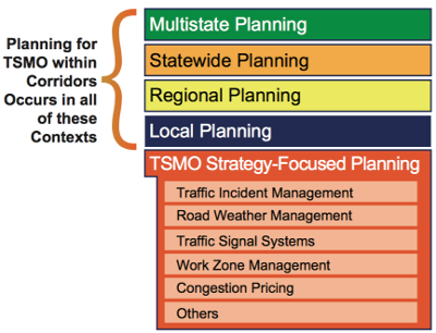 Figure 5. Diagram. Transportation systems management and operations planning within corridors occurs in a range of planning contexts and includes planning for a specific TSMO strategy. This section explores the range of planning contexts for TSMO within corridors (Figure 5). These contexts include multistate, statewide, regional, and local planning. That includes planning that is focused on one or more TSMO strategies such as traffic incident management or road weather management. Below is a description of the common contexts for TSMO planning and how planning for TSMO within corridors has been involved. Following these descriptions is a more in-depth look at the corridor planning contexts in terms of four dimensions: the motivation or impetus for the corridor TSMO planning effort ("why"), the lead organization ("who"), the timeframe for the plan ("when"), and the geographic extent of the corridor ("where"). Advancing Transportation Systems Management and Operations within Corridors in Several Planning ContextsAt the statewide level, planning for TSMO takes many forms. Planning for how TSMO will be conducted may be incorporated broadly in the State's long-range transportation plan, which is developed by the State DOT in collaboration with the State's MPOs and other transportation stakeholders. The State's long-range transportation plan may contain TSMO elements that are part of a larger multistate initiative that individual States agree to support (e.g., a multistate road-weather information system or traveler information system). TSMO planning also may be performed at the district level, across a state, where each State DOT district develops its own strategic operations plan in coordination with the MPOs and local agencies in the DOT district. Alternatively, TSMO planning may occur at the corridor level, across the state, especially where a State has identified priority corridors where there are specific needs (e.g., improved goods movement from a seaport; more efficient commuter options to and from major employment areas; or better access to major entertainment, recreational, or sports venues). The 2012 Surface Transportation Authorization Act, Moving Ahead for Progress in the 21st Century, requires that "[t]he statewide transportation plan and the transportation improvement program developed for each State shall provide for the development and integrated management and operation of transportation systems and facilities…"23 States are encouraged to include TSMO in their long-range transportation plans developed through performance-based planning.24 For more information on planning for TSMO at the Statewide level, readers should consult the Federal Highway Administration's (FHWA's) Statewide Opportunities for Integrating Operations, Safety and Multimodal Planning: A Reference Manual.25 At the metropolitan level, planning for TSMO often is led or facilitated by the MPO, which convenes a group of TSMO stakeholders, typically including State DOT district or regional offices, to advance TSMO in the region. Metropolitan planning for operations is frequently conducted in coordination with the development of the metropolitan transportation plan as a means of including TSMO priorities and strategies into the overall metropolitan transportation plan and including TSMO program and projects in the transportation improvement program (TIP). The FHWA recommends that planning for TSMO at the metropolitan (as well as statewide) level be driven by outcomes-oriented objectives and performance measures. Rather than focusing on projects and investment plans, the planning for operations approach emphasizes, first, developing objectives for transportation system performance, and then using performance measures and targets as a basis for identifying solutions and developing investment strategies. This is called the "objectives-driven, performance-based approach." The FHWA provides more information on using this approach to integrate TSMO into the metropolitan transportation planning process in a key document: Advancing Metropolitan Planning for Operations: The Building Blocks of a Model Transportation Plan Incorporating Operations - A Desk Reference.26 Planning for TSMO within corridors occurs at the metropolitan level when MPOs use corridors as the geographic unit for conducting the congestion management process or other operations related planning. Local or subarea planning refers to planning which addresses "A defined portion of a region (such as a county) in more detail than area-wide or regional plans. Subarea studies are similar to corridor studies, with the distinction that a subarea study generally addresses more of the total planning context and the broader transportation network for the area."27 Because subarea planning addresses a fairly broad planning context, this often involves a larger number of potentially affected stakeholders and comprehensive visioning for the area. Local studies may address a municipality (city or county) or other area, and may include a wide array of different issues, including transportation, land use, and urban design. Corridor planning for TSMO also occurs at the local level (e.g., when one or more local agencies want to address mobility issues on an individual corridor). Corridor planning focuses on planning for a linear system of multimodal facilities in which an existing roadway or transit facility will typically serve as the "backbone" of the corridor. The travel-shed helps determine the length and breadth of a corridor area, which usually connects major activity centers or logical destinations. Corridors can range in length from a few miles in an urban location to hundreds of miles for State or multistate corridors. In addition to different spatial scales, corridors also may have different modal foci (e.g., freight rail corridor, high capacity passenger rail corridor, limited-access highway corridor, or bus rapid transit corridor). Usually, corridor planning focuses on a combination of modes and a network of facilities. Statewide and metropolitan long-range transportation plans establish the policy framework for corridor, local, and subarea planning and provide guidance in terms of regional and statewide priorities related to goals, objectives, strategies, and transportation investments. MPOs, counties, and cities commonly lead local and subarea planning efforts. Corridor studies and planning activities are often performed by State DOTs and MPOs. Corridor improvements to achieve goals and objectives may include major capital investments in new capacity or infrastructure, which are typically incorporated into the State or MPO long range transportation plan. They also may take the form of improvements in the way the existing capacity in the corridor is managed, including investments in TSMO strategies that also may require capital investment and should be included in State and MPO long-range plans and TIPs as part of the planning for operations approach. Statewide and regional TSMO or ITS plans and associated architectures are a resource that can inform corridor, local, and subarea planning activities. These plans typically include existing and planned TSMO strategies that have been identified for statewide or metropolitan area use. Some include suggested TSMO strategies or implementation projects for specific subareas or an entire toolbox of potential strategies to consider. The Who, Why, When, and Where of Transportation Systems Management and Operations Planning within CorridorsThe contexts for corridor TSMO planning can be understood in the simple terms of who, why, when, and where (Figure 6). Why?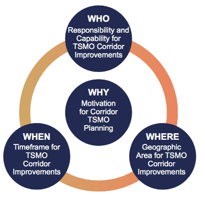 Figure 6. Graphic. Context for transportation systems management and operations planning within corridors. Example Context 1: Strong regional planning for operations supports corridor planning.
The why also might be the result of growing concerns about congestion, safety, air quality, reliability, or other recurring problems within a corridor, which may or may not be addressed in regional transportation plans. The motivation also might come as a result of a major incident that resulted in significant delays or that highlighted deficiencies in the existing corridor capacity (see Example Context 2). Interest in TSMO strategies in a corridor also might arise in conjunction with new capacity expansion projects when integrating TSMO strategies and tactics can be most cost effective (see Example Context 3). Example Context 2: Transportation systems management and operations applications are largely outside the regional planning process, such as traffic incident management (TIM).
Example Context 3: Corridor or facility study does not include transportation systems management and operations (TSMO) as initial focus, such as a rural corridor safety audit.
Who?The who for TSMO planning for corridors establishes responsibility for planning and implementing TSMO strategies within a corridor that, in many cases, spans multiple jurisdictions and requires interagency and multijurisdictional agreements regarding responsibilities for planning, designing, implementing, operating, monitoring, and maintaining TSMO strategies and tactics. This could be an authority acting on behalf of multiple entities (e.g., a toll authority or regional transit authority) or a single entity designated as the lead agency on behalf of other jurisdictions or agencies. Alternatively, if the corridor of interest is within a single jurisdiction, responsibility may lie with a single agency within the jurisdiction, but, even in this case, there are likely to be other agencies and jurisdictions that are affected by decisions made with respect to the corridor of interest, thus communication and coordination with these agencies and jurisdictions is important to the success of the TSMO improvements in the corridor. The who in TSMO planning for corridors reflects the capacity and experience of the responsible agency or agencies. Agencies with considerable experience in TSMO planning will have tools needed to evaluate various TSMO strategies and will understand the data available to evaluate these strategies. Agencies with less institutional knowledge and experience with TSMO strategies and tactics can draw on external expertise to assist in integrating TSMO into corridor planning. Moreover, those with less experience may find institutional resistance to considering and committing resources to TSMO improvements and may need to enlist the support of champions who can help make the case for TSMO as a means for improving transportation system performance within the corridor. In many, perhaps most, cases, a regional entity, such as an MPO or the major jurisdiction (e.g., city, county, or parish), will serve as the lead or facilitating entity for convening multiple agencies and jurisdictions to develop operations objectives for the corridor under consideration. State DOT district or regional offices also are likely to be involved because, in many states, the State DOT is responsible for maintenance and operations on major arterials. Other local and State agencies, such as law enforcement, also may be engaged, because they are often the entities most visible to the traveling public and will have significant responsibility for implementing and enforcing new operations strategies. Where?The where of TSMO planning for corridors is critical both to identifying key entities responsible for planning and implementing TSMO strategies and tactics and to determining who will benefit or be otherwise affected by TSMO strategies and tactics considered for the corridor. For example, the I-95 Corridor Coalition, a multistate coalition on the east coast, was originally formed as a way to coordinate major construction projects and inform motor carriers so that they could anticipate delays and plan their routes and schedules accordingly. However, the coalition has expanded to provide extensive traveler information to all travelers in the corridor; to coordinate formation of a seamless multistate electronic toll collection system (EZPass); and to collect and disseminate information regarding emergencies and incidents up and down the corridor, including advisories regarding delays and alternative routes. Other multistate corridor coalitions have been formed to provide traveler information to motor carriers and other travelers, especially in areas subject to frequent and severe weather events. More often, however, corridors of interest are within or between major population centers and are critical to moving goods and people that are essential to economic activity along the corridor and in the broader region. For example, the I-80 Integrated Corridor Mobility Project in California addressed a highly congested, 20-mile stretch of I-80 on the eastern side of the San Francisco Bay Area, extending from Carquinez Bridge to Bay Bridge (see Figure 7).28 In this case, geographical features and developed areas prevented further expansion of the facility; therefore, a multimodal, systems management approach was necessary. The corridor management project, planned and implemented through a partnership including Caltrans, the Alameda County Congestion Management Agency, and the Contra Costa County Transportation Authority sought to: 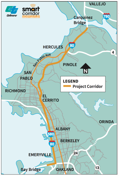 Figure 7. Map. The Interstate 80 Integrated Corridor Mobility Project area map in California. Source: Caltrans
Because of the geographic location of the portion of the I-80 corridor included in the project, 17 jurisdictions, agencies (Federal, State, and local), and regional authorities were involved in the corridor project as primary stakeholders. Consequently, the level of coordination required among the primary stakeholders and other interests (e.g., neighborhoods, commercial spaces, shippers, and carriers) was directly affected by the geographic location of the corridor. When?The when of TSMO corridor planning considers both the point at which TSMO planning takes place and the timeframe for TSMO strategies and tactics. TSMO corridor planning is most effective when integrated into the planning process for a new facility or when an existing facility is expanded or undergoing major renovation. At that time, plans for TSMO projects that require the installation of technology (e.g., cameras, fiber optics, and dynamic message signs) or roadway features (e.g., turn lanes and full-depth shoulders) can be included in the design most effectively. However, in many cases, TSMO strategies are considered only when available capacity no longer accommodates current or projected demand, and TSMO strategies and tactics are viewed as the most appropriate way to improve transportation system performance, as in the I-80 example above. In addition to when the TSMO corridor plans are developed and implemented in a corridor, the TSMO corridor planning process considers the timeframe for implementation and operation of the TSMO investments. TSMO investments typically have short returns-on-investment (ROI) relative to other investments in transportation infrastructure and so can be justified based on much shorter life cycles than can major capacity expansion projects. On the other hand, such investments tend to be technology intensive and, with relatively rapidly changing technology, investments in these strategies must be made with an eye toward next-generation technologies and capabilities. As more advanced technologies emerge in sensors, vehicles, communications, visualization, and others, TSMO corridor planning should consider how current TSMO investments will accommodate future upgrades and new capabilities that may make past investments less attractive. Examples of Current PracticesBelow are brief examples of current practices for TSMO planning at the corridor level. These help to illustrate the wide breadth of activities that are considered to be planning for TSMO within corridors:
23 Title 23 United States Code Section 135(a). Return to note 23. 24 Federal Highway Administration, Model Long-Range Transportation Plans: A Guide for Incorporating Performance-Based Planning, FHWA-HEP-14-046 (Washington, DC: August 2014). Available at: https://www.fhwa.dot.gov/planning/performance_based_planning/mlrtp_guidebook/. Return to note 24. 25 Federal Highway Administration, Statewide Opportunities for Integrating Operations, Safety and Multimodal Planning: A Reference Manual, FHWA-HOP-10-028 (Washington, DC: June 2010).Available at: https://www.fhwa.dot.gov/planning/processes/statewide/practices/manual/index.cfm. Return to note 25. 26 Federal Highway Administration and Federal Transit Administration, Advancing Metropolitan Planning for Operations: The Building Blocks of a Model Transportation Plan Incorporating Operations - A Desk Reference, FHWA-HOP-10-027 (Washington, DC: 2010). Available at: https://ops.fhwa.dot.gov/publications/fhwahop10027/. Return to note 26. 27 Federal Highway Administration, Guidance on Using Corridor and Subarea Planning to Inform NEPA (Washington, DC: April 2011). Available at: http://environment.fhwa.dot.gov/integ/corridor_nepa_guidance.asp#toc212. Return to note 27. 28 California Department of Transportation, I-80 Smart Corridor Project, Web site. Available at: http://80smartcorridor.org/. Return to note 28. 29 California Department of Transportation, South Bay Corridor Study and Evaluation for Dynamic Corridor Congestion Management (DCCM), Presentation to Metro Streets and Freeways Subcommittee Meeting, October 17, 2013. Available at: http://media.metro.net/about_ us/committees/sfs/images/sfs_item10_10_2013.pdf. Return to note 29. 30 City of Fort Collins, Harmony Road ETC Master Plan, June 2013. Available at: http://www.fcgov.com/transportationplanning/pdf/harmonydraft-report.pdf. Return to note 30. 31 Delaware Valley Regional Planning Commission, I-95 Road Safety and Operations Audit (RSOA) — Delaware County, December 2011. Available at: http://www.dvrpc.org/reports/10011.pdf. Return to note 31. 32 Florida Department of Transportation, "Statewide Active Arterial Management Needs Plan," (July 2013). Unpublished. Return to note 32. 33 San Joaquin Council of Governments, Final Report for: I-580 Interregional Multimodal Corridor Study, Aug 2011. Available at: http://www.sjcog.org/DocumentCenter/View/44. Return to note 33. 34 DKS Associates, US 20/OR 34 Optimization Study Final Report, February 2015. Prepared for Oregon Department of Transportation Region 2. Return to note 34. |
|
United States Department of Transportation - Federal Highway Administration |
||