Planning for Transportation Systems Management and Operations Within Corridors: A Desk ReferenceChapter 1. IntroductionOverview of Desk ReferenceOver the past decade, transportation agencies have increasingly integrated transportation systems management and operations (TSMO) in planning at the statewide and metropolitan levels. Using an objectives-driven, performance-based approach, State departments of transportation (DOTs) and metropolitan planning organizations (MPOs) around the country are working with local jurisdictions, transit agencies, law enforcement, toll authorities, and other partners to manage traffic congestion, improve system reliability, increase safety, and enhance multimodal options using operations solutions. Rather than relying solely on new highway and transit capacity, this approach recognizes that TSMO strategies (e.g., enhanced incident management, traffic signal coordination, transit signal priority (TSP), and traveler information) can often be low in cost, highly effective, and implemented in concert with infrastructure to enhance transportation system performance. Planning for operations involves identifying operations objectives and performance measures, which guide the identification, prioritization, and selection of investments, programs, and strategies. The result is implementation of programs, projects, and collaborative efforts to better manage and operate transportation systems and services to preserve capacity and improve security, safety, and reliability of the transportation system. Today, many State DOTs and MPOs have policies to improve transportation operations by first managing travel demand and applying management techniques prior to considering additional capacity for a roadway. While many statewide and regional policies and programs are advancing implementation of effective TSMO strategies, more benefits will occur when TSMO is considered and applied strategically at a smaller scale where many critical implementation decisions are made. Transportation within corridors presents opportunities for agencies to plan for operations at a more-refined geographic scale and at a level where specific and actionable plans can be developed. Increasingly, transportation agencies are recognizing the value of a corridor approach instead of looking at individual transportation projects on a piecemeal or single facility basis. A corridor approach takes a broad view of the interconnected factors that influence travel and enables more creative and collaborative approaches for addressing transportation problems. While, traditionally, corridor planning has often focused on improving the performance of an individual highway facility, increasingly, transportation planners and operators view corridors as an interconnected network of facilities and services. Managing mobility on a corridor by leveraging all modal choices and assets is called integrated corridor management (ICM), an approach to managing corridors that is being used on several major corridors across the United States.1 This Desk Reference describes an approach for planning for TSMO within corridors that incorporates the ICM concept of looking beyond a single highway facility to parallel routes and transit services and focuses on the performance of the corridor travel-shed from the customer's perspective. Transportation Systems Management and Operations is...? "…[a set of] integrated strategies to optimize the performance of existing infrastructure through the implementation of multimodal and intermodal, cross-jurisdictional systems, services, and projects designed to preserve capacity and improve security, safety, and reliability of the transportation system." It "includes - (i) actions, such as traffic detection and surveillance, corridor management, freeway management, arterial management, active transportation and demand management, work zone management, emergency management, traveler information services, congestion pricing, parking management, automated enforcement, traffic control, commercial vehicle operations, freight management, and coordination of highway, rail, transit, bicycle, and pedestrian operations; and (ii) coordination of the implementation of regional transportation system management and operations investments (e.g., traffic incident management, traveler information services, emergency management, roadway weather management, intelligent transportation systems, communication networks, and information sharing systems) requiring agreements, integration, and interoperability to achieve targeted system performance, reliability, safety, and customer service levels." Source: 23 United States Code Section 101(a)(30). Transportation agencies and stakeholders, however, often have started corridor studies from a perspective that focuses on investment needs to address traffic level of service (LOS) or other issues that result in proposals for expensive capital investments that may be outside the available resources. Moreover, while TSMO may be identified as a priority from a statewide or regional perspective, strategies are often applied at a broad scale (e.g., through a statewide incident management program, a regional ridesharing program, or traveler information systems) without further connecting these programs to corridor operations or designing TSMO strategies and investments that are targeted to address unique corridor challenges and conditions. This Desk Reference is designed to equip State, regional, and local transportation operations and planning professionals with the knowledge and tools necessary to effectively plan for and implement TSMO within a corridor context. Its purpose is to support transportation planners and operations staff in planning for and applying TSMO activities within corridors to achieve a more reliable, efficient, and livable outcome from their existing and planned transportation infrastructure. Utilizing a planning for operations approach at a corridor level can help to focus on issues (e.g., mobility, reliability, and safety) from a multimodal perspective and bring to light cost-effective demand management and operations solutions that may not otherwise have been fully considered. The document describes planning for TSMO at the corridor level so that readers can tailor and apply this approach in a variety of corridor contexts. This Desk Reference is founded upon three themes for success that cut across all TSMO planning efforts:
The Desk Reference connects readers to other tools and resources developed by the Federal Highway Administration (FHWA) and partners to support a more in-depth understanding of several topics introduced in this document. It draws upon concepts, such as ICM and active transportation demand management (ATDM), that are increasingly focusing attention on collaboration across multimodal system operators and planners to address corridor conditions. Quick reference sheets provide examples of corridor operations objectives, performance measures, and the management and operations strategies that can be applied as readers move forward in applying the components of planning for and implementing TSMO within corridors. This Desk Reference is a companion to the FHWA Planning for Transportation Systems Management and Operations within Subareas: A Desk Reference, a resource that addresses the specific needs of organizations planning for TSMO at the local or subarea level.2 Who Should Use this Desk Reference?This Desk Reference is intended for the transportation planning or operations professional who is looking to address specific questions on planning for TSMO within corridors, as well as the professional who wants to gain a comprehensive understanding of how to successfully improve travel and goods movement on a corridor. This document brings together planning and operations approaches, practices, and lessons that have been developed over the past 10 years and provides consolidated assistance on planning for TSMO at the corridor level. Several sections serve as launching points to related FHWA documents that provide more in-depth information and tools. Readers will find links and references to technical assistance materials alongside related content introduced in this Desk Reference. OrganizationThe desk reference is organized into six sections: Chapter 1: IntroductionProvides a brief introduction to TSMO within corridors and planning for TSMO in a variety of corridor contexts. Helps readers identify the need for TSMO planning at the corridor level. Related technical assistance materials:
Chapter 2: Planning for Transportation Systems Management and Operations within CorridorsMakes the case for TSMO planning to achieve coordinated and strategic implementation and ongoing use of TSMO strategies. Provides an overview of the planning context for TSMO on a corridor, and describes examples of current practice. Related technical assistance materials:
Chapter 3: Approach to Corridor Planning for Transportation Systems Management and OperationsLays out a common-sense approach to planning for TSMO on a corridor for a variety of corridor contexts. Takes the reader from building a team for the effort to selecting TSMO strategies that will best achieve the corridor operations objectives. Provides easy-to-use reference guides for a range of operational objectives relevant to multimodal corridors, including corridor travel time, traffic signal management, transit priority, and bicycle and pedestrian accessibility and efficiency. Related technical assistance materials: In addition to the resources listed for Chapters 1 and 2, this chapter draws from:
Chapter 4: Moving to Implementation: Transportation Systems Management and Operations within CorridorsOffers information on how to go from plans for TSMO to implementation, monitoring, and maintenance of TSMO strategies. This includes obtaining funding for TSMO, agreeing upon organizational roles and responsibilities, applying systems engineering, and regularly evaluating the effectiveness of the implemented strategies in relation to the corridor objectives. Related technical assistance materials:
Chapter 5: Toolbox for Effective Transportation Systems Management and Operations PlanningIntroduces several tools to help ensure effective planning for TSMO at the corridor level, including scenario planning, analysis tools, and benefit-cost analysis. Related technical assistance materials: Chapter 6: Taking ActionDescribes key actions that readers can take to jump start their efforts to advance TSMO on a corridor.Transportation Systems Management and Operations within CorridorsWhat is Transportation Systems Management and Operations?TSMO encompasses a broad set of strategies that aim to optimize the safe, efficient, and reliable use of existing and planned transportation infrastructure for all modes. TSMO is undertaken from a systems perspective, which means that these strategies are coordinated with related strategies and across multiple jurisdictions, agencies, and modes. TSMO strategies range from regional traffic signal systems management to shared-use mobility initiatives (see Table 1 for an expanded list of strategies). TSMO includes efforts to operate the multimodal transportation system and activities to manage travel demand. TSMO proactively addresses a variety of transportation system user needs by:18
TSMO strategies are supported by both institutional and technology-based activities. For example, TSMO is enabled by memoranda of agreement between agencies, operational policies and procedures, and shared resources (e.g., interoperable communications systems, centralized traffic signal operations, and closed circuit television video sharing). What are the Benefits of Transportation Systems Management and Operations?19TSMO strategies have allowed transportation agencies to address transportation issues in the near-term, with lower-cost solutions. TSMO strategies deliver a variety of benefits. These include:
Sample of Transportation Systems Management and Operations Strategies Relevant to CorridorsMany TSMO strategies are applicable and effective at the corridor level. Table 1 lists TSMO strategies that agencies can consider when looking to improve the operation of their corridors. Table 1. Sample of transportation systems management and
operations strategies relevant to corridors.
Transportation Systems Management and Operations within Corridors: Understanding the Corridor Contexts20When developing strategies for TSMO within corridors, it is critical to understand the context for the corridor, including surrounding land uses and development patterns, available travel options (e.g., highway, road network, transit, and non-motorized options), and the types of system users (e.g., freight, commuters, and interstate travelers) and their needs and priorities. A corridor generally includes multiple freeways, arterial roadways, transit services, bicycle and pedestrian connections, park-and-ride lots, and rideshare services serving people traveling in similar directions.
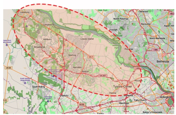
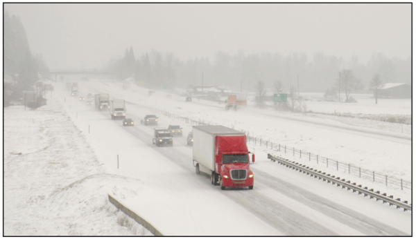
Different types of corridors are found in urban, suburban, and rural contexts. Many corridors traverse multiple contexts. To optimize performance of the transportation system and meet user needs, TSMO within a corridor should reflect the unique form, use, and needs of the corridor. Some typical types of contexts include: A Complex Corridor in an Urbanized Area, with a Major Arterial and/or Transit Line "Spine"Urban centers are dense areas with high levels of activity and where complex, multimodal transportation systems offer options for taking transit, walking, and biking. Corridor planning in urban centers may be focused on a major arterial roadway, a rail line or major bus corridor, or a combination. TSMO strategies for urban corridors may focus on multimodal system performance and managing travel demand and may include a wide array of strategies, including parking management, TSP, dynamic ridesharing, bikesharing, pedestrian count-down signals, real-time, multimodal traveler information, and traffic signal coordination. A Complex Corridor in a Suburban or Urbanized Area, with a Major Freeway as a "Spine" and Associated AlternativesSuburban communities are less dense than a downtown core, and corridors are often defined based on major highways or arterials that may serve a combination of commuters, other travelers, and freight. For these corridors, TSMO strategies may focus on managing traffic and incidents to provide predictable travel times, shifting demand to transit and ridesharing, and balancing travel loads across the network. Examples of TSMO investments may include adaptive ramp metering, dynamic high-occupancy vehicle or managed lanes, and dynamic merge or junction control. 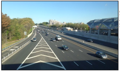 Figure 2. Photo. The Dulles Corridor in Northern Virginia is an example of a corridor defined around a major highway and passenger rail spine with adjoining roadways, park-and-ride facilities, and surrounding business and residential land uses. Source: Michael Grant. Corridors in Rural AreasIn rural areas, development is limited and dispersed, and travel options are often limited. While congestion is generally a minor concern, traffic safety and weather conditions (e.g., snow, ice, rain, and fog) are often significant concerns. Some rural areas also may experience seasonal, off-peak congestion due to tourism or events (e.g., festivals, etc.). In addition, in some small towns, stretches of State highways serve as main streets and may attract pedestrian and bicycle use. Given the infrequent congestion on rural roads, the more-aggressive TSMO strategies used in urban and suburban areas may not warrant deployment. TSMO strategies for corridors in rural areas require a flexible approach tailored to specific characteristics of the corridor and may include strategies such as road weather management and dynamic routing. These are just three examples of ways in which corridor contexts can differ. Many States and communities define corridor contexts in their own unique ways. For instance, in its Smart Mobility Framework, the California Department of Transportation (Caltrans) has defined seven "place types," which are used to create distinct contexts for transportation investments and operational performance:
These different contexts are used to define appropriate sets of strategies, encompassing both infrastructure investments and operational strategies. For instance, Caltrans notes that reliability is a key objective guiding investment and operations in urban centers, providing people with the ability to conveniently use walk, bike, and high-capacity transit modes, as well as supporting street and intersection operations that focus on providing predictable travel times with traffic and incident management. Conversely, rural and agricultural lands have fewer modal options due to their more limited activity areas. It also is important to consider that the context may change throughout the length of a corridor, and the different segments may warrant different TSMO strategies.
Typically, a corridor will span multiple jurisdictions and agencies responsible for different components of system operations, including traffic signals, traveler information systems, and maintenance functions. Consequently, involving a wide range of agencies with corridor responsibilities is critical to taking a successful corridor approach to TSMO. Who Performs Transportation Systems Management and Operations within Corridors?While the lead agencies in managing and operating the transportation system are typically the owners of the facilities (i.e., State and local DOTs, roadway authorities, and transit agencies), many other partners are involved in how corridors are managed, and these relationships are critical for corridor operations. For example, effective TIM involves coordination among several different groups, including responders from a variety of disciplines (e.g., law enforcement, fire and rescue, and towing and recovery), as well as the DOT or transportation management center (TMC) staff. Implementation of TSP requires coordination between transit agencies that operate services and DOTs that are responsible for arterial roadway operations. Work zone management involves coordinating alternate routes between agencies and their contractors involved in construction and infrastructure renewal, other transportation agencies and services that use the facility or connect to the facility, as well as TMC and public relations staff who provide information to the public. Transportation demand management (TDM) programs often work directly with employers to promote travel options to their employees and may include efforts to support customized travel planning in communities, support for school-based programs to support bicycling and walking, and other options. At a regional level, MPOs play a critical role in TSMO, both by convening collaborative relationships among diverse agencies and organizations that play a role in transportation system operations, as well as through implementation of TSMO programs. For example, the Metropolitan Transportation Commission in the Bay Area of California operates the Bay Area 511 system. The Denver Regional Council of Governments provides engineering support to cities and counties in the region for signal retiming. The National Capital Region's Transportation Planning Board manages the region's Commuter Connections program, which supports ridesharing, transit, walking, biking, and other options.22 Over the past decade, TSMO has benefited from rapidly advancing technology and an increased emphasis on cost-effective transportation solutions. TSMO now appears to be headed into an era where State DOTs are elevating TSMO as a top priority and systematically increasing their operational capabilities. MPOs are consistently planning and programming for TSMO and spearheading regional collaboration for TSMO. Local governments, with responsibility for operating traffic signals, transit services, road maintenance and snow removal, local police forces, and other services, play an increasingly important role as TSMO strategies become part of corridor, local, and subarea plans. Advances in vehicle and infrastructure technology and communication systems promise to shift the paradigm of how infrastructure, people, vehicles, and operators interact to change the way safe, efficient, and reliable transportation is provided. A wide range of transportation-related agencies often plays a role in how transportation systems are managed and operated, such as:
Even in cases where a TSMO strategy is being implemented or operated by a single entity or agency (e.g., a freeway management system that is managed by a State DOT), there are typically many different partners that should help to inform or play a role in those operations, such as:
TSMO strategies, whether or not they are implemented and operated by a single entity or agency, involve building consensus around needs, priorities, performance measures, resources, and responsibilities. As a result, the corridor planning or study process should recognize the importance of key stakeholders in the corridor who will be affected by—and whose support is needed to identify and advance—appropriate TSMO strategies in the corridor, including non-traditional stakeholders. Local businesses, neighborhood associations, bicycle/pedestrian advocates, and others will likely be engaged in the decision-making process and will need to be informed of alternatives, benefits, and potential or perceived negative effects of TSMO strategies under consideration. Rather than optimizing individual services or facilities, effective corridor operations involve optimizing from an overall system perspective. 1 U.S. Department of Transportation, Integrated Corridor Management (ICM) Knowledge and Technology Transfer Factsheet, FHWAJPO-14-151 (Washington, DC: 2014). Available at: http://www.its.dot.gov/factsheets/pdf/ICM_KTT_V5.pdf. Return to note 1. 2 Federal Highway Administration, Planning for Transportation Systems Management and Operations within Subareas: A Desk Reference. Available Spring 2016 at https://ops.fhwa.dot.gov/plan4ops/index.htm. Return to note 2. 3 Federal Highway Administration and Federal Transit Administration, Advancing Metropolitan Planning for Operations: An Objectives–Driven, Performance–Based Approach — A Guidebook, FHWA-HOP-10-026 (Washington, DC: 2010). Available at: https://ops.fhwa.dot.gov/publications/fhwahop10026/. Return to note 3. 4 Federal Highway Administration and Federal Transit Administration, Advancing Metropolitan Planning for Operations: The Building Blocks of a Model Transportation Plan Incorporating Operations - A Desk Reference, FHWA-HOP-10-027 (Washington, DC: 2010). Available at: https://ops.fhwa.dot.gov/publications/fhwahop10027/. Return to note 4. 5 Federal Highway Administration, Performance Based Planning and Programming Guidebook, FHWA-HEP-13-041 (Washington, DC: September 2013). Available at: https://www.fhwa.dot.gov/planning/performance_based_planning/pbpp_guidebook/. Return to note 5. 6 Federal Highway Administration, Statewide Opportunities for Integrating Operations, Safety and Multimodal Planning: A Reference Manual, FHWA-HOP-10-028 (Washington, DC: June 2010). Available at: https://www.fhwa.dot.gov/planning/processes/statewide/practices/manual/index.cfm. Return to note 6. 7 Federal Highway Administration, The Collaborative Advantage: Realizing the Tangible Benefits of Regional Transportation Operations Collaboration, FHWA-HOP-08-001 (Washington, DC: August 2007). Available at: https://ops.fhwa.dot.gov/publications/benefits_guide/index.htm. Return to note 7. 8 Federal Highway Administration, Regional Transportation Operations Collaboration and Coordination: A Primer for Working Together to Improve Transportation Safety, Reliability, and Security, FHWA-OP-03-008 (Washington, DC: 2003). Available at: http://ntl.bts.gov/lib/jpodocs/repts_te/13686.html. Return to note 8. 9 Federal Highway Administration, Operations Benefit/Cost Analysis Desk Reference, FHWA-HOP-12-028 (Washington, DC: May 2012). Available at: https://ops.fhwa.dot.gov/publications/fhwahop12028/index.htm. Return to note 9. 10 Federal Highway Administration, The Role of Transportation Systems Management and Operations in Supporting Livability and Sustainability: A Primer, FHWA-HOP-12-004 (Washington, DC: January 2012). Available at: https://ops.fhwa.dot.gov/publications/fhwahop12004/. Return to note 10. 11 Federal Highway Administration, Guide for Highway Capacity and Operations Analysis of Active Transportation and Demand Management Strategies, FHWA-HOP-13-042 (Washington, DC: June 2013). Available at: https://ops.fhwa.dot.gov/publications/fhwahop13042/fhwahop13042.pdf. Return to note 11. 12 U.S. Department of Transportation, Integrated Corridor Management: Implementation Guide and Lessons Learned, FHWA-JPO-12-075 (Washington, DC: February 2010). Available at: http://ntl.bts.gov/lib/47000/47600/47670/FHWA-JPO-12-075_FinalPKG_508.pdf. Return to note 12. 13 Federal Highway Administration, PlanWorks: Linking Planning and Operations, Web site. Available at: https://fhwaapps.fhwa.dot.gov/planworks/Application/Show/7. Return to note 13. 14 Federal Highway Administration, Applying a Regional ITS Architecture to Support Planning for Operations: A Primer, FHWA-HOP-12-001 (Washington, DC: February 2012). Available at: https://ops.fhwa.dot.gov/publications/fhwahop12001/index.htm. Return to note 14. 15 Federal Highway Administration, Programming for Operations: MPO Examples of Prioritizing and Funding Transportation Systems Management and Operations Strategies, FHWA-HOP-13-050 (Washington, DC: September 2013). Available at: https://ops.fhwa.dot.gov/publications/fhwahop13050/index.htm. Return to note 15. 16 Federal Highway Administration, Designing for Transportation Management and Operations: A Primer, FHWA-HOP-13-013 (Washington, DC: February 2013). Available at: https://ops.fhwa.dot.gov/publications/fhwahop13013/index.htm. Return to note 16. 17 Federal Highway Administration, The Regional Concept for Transportation Operations: A Practitioner's Guide, FHWA-HOP-11-032 (Washington, DC: July 2011). Available at: https://ops.fhwa.dot.gov/publications/fhwahop11032/index.htm. Return to note 17. 18 Federal Highway Administration, Office of Operations, "The Operations Story," Presentation, 2012, Jeffrey A. Lindley. Return to note 18. 19 U.S. Department of Transportation, Intelligent Transportation Systems Joint Program Office, Investment Opportunities for Managing Transportation Performance through Technology, January 2009. Available at: http://www.its.dot.gov/press/pdf/transportation_tech.pdf. Return to note 19. 20 California Department of Transportation, Smart Mobility, 2010. A Call to Action for the New Decade (California: 2010). Available at: http://www.dot.ca.gov/hq/tpp/offices/ocp/smf_files/SmMblty_v6-3.22.10_150DPI.pdf. Return to note 20. 21 Ibid. Return to note 21. 22 National Capital Region Transportation Planning Board, Metropolitan Washington Council of Governments, Commuter Connections, Web site. Available at: http://www.commuterconnections.org/. Return to note 22. | |||||||||||||||||||
|
United States Department of Transportation - Federal Highway Administration |
||