Advancing Transportation Systems Management and Operations through Scenario PlanningSection 3: Applying the Scenario Planning Approach to Planning for Transportation Systems Management and OperationsWherever transportation infrastructure exists, communities face the challenge of planning to manage and operate it. Transportation systems management and operations (TSMO) planning occurs at all geographic scales, including local, corridor, subregional, regional, metropolitan, statewide, and multi-state. TSMO planning efforts range from informal to formal and cover a spectrum of temporal scales—from a few weeks to many decades. In addition, the functional scope of TSMO planning may be a single TSMO strategy or program (e.g., regional signal coordination, transportation management centers, traffic incident management) or all TSMO strategies and every combination in between. While the scenario planning approach could be used in any of these contexts, this primer will illustrate how scenario planning can be incorporated into a handful of TSMO planning efforts. Scenario planning can create a more robust and effective approach to planning for TSMO in a variety of contexts. The scenario planning approach can confer benefits for all TSMO planning efforts, especially in cases where there is a significant level of uncertainty about the future or there is a need to resolve conflicts about how a particular area or corridor might develop over time. The scenario planning approach can be particularly effective for TSMO planning when the transportation service providers and other stakeholders must arrive at decisions about operations when there are differing assumptions about future events, trends, policies, or other factors that will significantly impact the successful outcomes of operations decisions. For example, scenario planning can help a region decide how to invest in road weather management or hurricane evacuation operations given the uncertain impacts of climate change on weather patterns in the region. Alternatively, it could be applied in planning for intelligent transportation systems (ITS) equipment investments for a State's highway system over the next 5 years given the uncertainty in the pace and direction of technological innovations. Similarly, scenario planning can be effective when the stakeholder visions for an area are unclear or there are competing visions and goals about how an area should evolve. For instance, a stakeholder community may have differing ideas regarding the purpose and design of a street. One segment of the community may push to redevelop the street into a multimodal, suburban "Main Street" with development fronting the street, while another faction may be adamant about maintaining high-speed mobility for regional travelers by controlling vehicular access to adjacent development. Scenario planning could help the stakeholders develop a range of different futures that illustrate the tradeoffs of different corridor approaches and help clarify a preferred vision that sets the framework for identifying specific TSMO strategies to support that vision. In a TSMO context, the focus of the effort is not just on the road and land-use development patterns per se, but rather the TSMO-specific strategies to help optimize and improve the operations and management necessary for meeting travelers' needs. Typical considerations in a TSMO scenario planning process could include identifying strategies that address how long it takes to travel along a facility by different modes, what types of design features and amenities should be provided to various travel modes, or what new information technology and communications could be implemented to provide more accurate real-time travel times or options for different users. The primary goal of scenario planning is to identify a set of preferred TSMO strategies in response to a robust consideration of tradeoffs associated with different public policy goals or future uncertainties. Strategies such as increasing transit service and encouraging more non-motorized travel may be part of any solution, and will include the examination of multimodal metrics such as auto and non-auto travel time. Looking at these types of metrics will help stakeholders identify strategies to support improved transportation system management and operations. In addition, scenarios aimed at creating more resilient transportation systems might include identification of new investments needs in communication networks or identifying new measures or targets for getting the transportation system operational after a major weather event. The general approach to scenario planning provided by the Federal Highway Administration (FHWA) in its 2011 FHWA Scenario Planning Guidebook21 offers a useful structure to planners and operators as they shape their scenario planning effort for TSMO. This section looks closely at each phase in FHWA's scenario planning approach and describes how the scenario planning leaders would conduct each phase in the context of advancing TSMO, including the important questions to address. This section also distinguishes and clarifies the desired outputs during each phase. The end of this section provides an overview of analysis tools and models that could be used to support scenario planning for TSMO activities. Federal Highway Administration Scenario Planning Framework Applied to Transportation Systems Management and OperationsFigure 4 depicts the FHWA 2011 scenario planning framework, adapted to apply to TSMO planning contexts. The figure uses the same six phases as the FHWA scenario planning approach but defines each phase as it applies to TSMO. Instructions or questions to consider in the left column provide quick guidance on actions to take or questions to consider during each phase. The diagram also shows the primary outputs for each phase. There will be some difference in the implementation of this approach for each of the three types of scenario planning: predictive, normative, and exploratory. The unique aspects of these three types will be highlighted in the explanation of each phase below. 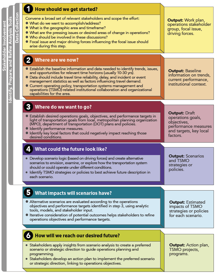 Figure 4. Diagram. The Federal Highway Administration Scenario Planning Framework Adapted to Transportation Systems Management and Operations. Phase by Phase: Process, Participants, and OutputsThe information below describes how each phase of scenario planning could be accomplished in the context of TSMO. Phase 1. How Should We Get Started?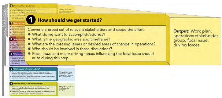 Figure 5. Diagram. Phase 1 of the Federal Highway Administration Scenario Planning Framework Adapted to Transportation Systems Management and Operations. During this phase, the leaders of the scenario planning effort bring together a broad set of relevant stakeholders to scope the effort by answering questions such as:
One of the perceived challenges of using scenario planning for TSMO is the inherent tension that exists in taking what is typically the shorter term (5-10 year time horizons) application of TSMO planning efforts, and expanding that view to allow for a longer term (20, 30 or 50+ year horizon) examination of potential futures. However, this perceived challenge is actually an opportunity to better define short-term, mid-term, and long-term TSMO strategies. It also helps create the foundation for TSMO implementation and monitoring to track progress against short- and long-term performance objectives. 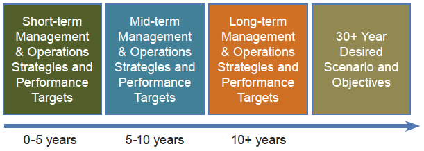 Figure 6. Diagram. Planning Horizons. A critical activity during this phase is to pinpoint the specific questions and desired outcomes that stakeholders want the scenario planning effort to address. Identifying the target questions will help the project leaders to select the type of process best suited to their needs, as shown in Table 3.
ITS = intelligent transportation systems
TMC = traffic management center TSMO = transportation systems management and operations In order to garner broad discussions, the leaders of a TSMO scenario planning activity, regardless of type, should engage a diverse stakeholder group in the process that reflects interests and expertise across disciplines. This group will help to confirm trends and factors that may influence those trends. This will in turn confirm the overall aspirations of the stakeholders and support the effort to develop strategies. This could include operators; transportation, land-use, and housing planners; emergency management professionals; traffic reporters; public information officers; local developers; demographers; communications and information technology experts; economic development officials; and representatives from State, city, and county departments of transportation (DOT); public works departments; transit agencies; port authorities; toll authorities or high-occupancy toll (HOT) lane operators; pedestrian and bicycle groups; disability advocacy organizations; universities; the trucking, rail, and port industry; and the private sector. Stakeholder identification can build upon the existing public outreach plans of the metropolitan planning organization (MPO), which often includes standing committees or stakeholder groups that are regularly engaged in long-range transportation planning or other cross-agency planning efforts within the region. For instance, many MPOs have a standing land use committee to aid in the development of long-term socioeconomic forecasts; in addition, many communities also have identified cross-agency representatives for emergency operations planning that could also be easily identified. Phase 2. Where Are We Now?At this stage it is important to gather the baseline information that will provide relevant context to help answer the target questions. This will likely include data for past trends, current conditions, and projected future trends that build off of the existing information in metropolitan or statewide transportation plans and records of travel conditions maintained by a transportation management center (TMC), DOT, or transit operating agency. If trying to conduct scenario planning to address extreme weather or climate change, it would be important to gather conditions and trends relative to transportation system performance under previous disruptions as well as information on future weather trends. Typically, TSMO-oriented scenario planning groups would gather transportation data needed to identify 10-year and 20-year trends and issues along with opportunities in growth and development. This may include travel demand, truck traffic, port use, transit ridership, and other information that may provide insights into travel demand, economic drivers, and other important factors that could influence system-wide transportation dynamics. 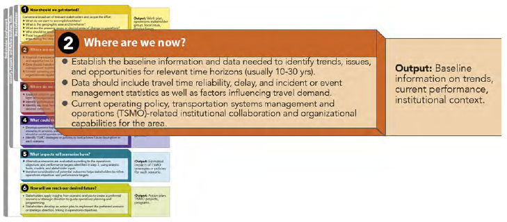 Figure 7. Diagram. Phase 2 of the Federal Highway Administration Scenario Planning Framework Adapted to Transportation Systems Management and Operations. The purpose of this initial data gathering effort is to understand the operations context in terms of future trends and how that relates to the questions of interest. For instance, questions that the stakeholders may want to answer through data gathering during this phase include:
This baseline data can come from sources and analysis associated with regional travel demand models, geographic information system (GIS) analysis of accessibility, and archived operations data. In addition, trends in technology use by operators and travelers should be considered for building scenarios in the next phases. This baseline information should also include the current operating and institutional policies for the region, corridor, or area of focus. It is also important to bring to any scenario planning effort the overall goals that are part of current, overarching documents such as the metropolitan transportation plan (MTP) or statewide long-range transportation plan. Long-range transportation plan goals would be a reasonable starting point for initiating discussions about operational goals and fostering more dialogue about how the transportation system ultimately can support a community's desired future. In addition, if the scenario process is exploratory, it may be helpful at this stage to discuss reasonable goals and expectations about how the transportation system ideally would function in response to specific events or weather occurrences. These goal-setting discussions set the context for the scenario planning effort. During this phase, it is important either to reaffirm existing goals or to identify new goals that can drive scenario development. Phase 3. Where Do We Want To Go?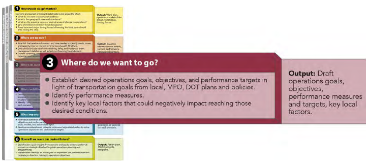 Figure 8. Diagram. Phase 3 of the Federal Highway Administration Scenario Planning Framework Adapted to Transportation Systems Management and Operations. With a solid understanding of the existing operations context and likely future trends, the next phase involves discussing and identifying specific operations goals and objectives for the transportation system. These discussions should be geared towards developing outcomes that describe different quality of life or value-oriented outcomes such as "we want to spend less time driving alone in our cars to meet our daily travel needs," or "we want to spend less time sitting in congestion," or "we want travelers to have all necessary information on travel time, mode, and costs in real-time to make better travel decisions," or "we want more reliable, comfortable, and healthy options for getting to and from work," or "we want to create a transportation system that helps reduce greenhouse gas emissions." Scenario Planning Adds Value One of the valued-added elements of using scenario planning to establish operations goals and objectives is that it can foster the discussion of operations objectives that can be both supported by transportation systems management and operations (TSMO) strategies as well as prompt development of a more holistic set of strategies across different sectors or implementing agencies. For instance, if the objective is to increase efficiency in non-single-occupancy-vehicle (SOV) trips, there may be a bundle of strategies that can be used to effect that change, such as travel demand management, transit signal prioritization, local land use policy changes, bus operational improvements or service expansions, improvements to bicycle and pedestrian infrastructure, congestion pricing, and place-based employer recruitment. Engaging representatives from different agencies in these early goal- and objective-setting conversations helps all parties better understand the relationships between different variables across community systems, revealing the interrelated nature of land use, transportation, economic development and resource protection. To foster the discussion, stakeholders might pose some of the following questions to help identify goals and desired outcomes:
At this phase, an important outcome is to start to identify some very concrete goals and objectives from which more specific operations objectives and performances measures can be developed and used to evaluate different scenarios and ultimately monitor system performance over time. This discussion should remain high-level in nature to ensure that the view points of the various stakeholders are reflected, but it should also be specific enough to generate ideas about operations objectives. Translating these goals into operations objectives using scenario planning requires an iterative approach. After identifying goals and understanding current conditions and trends, stakeholders could begin to identify their desired outcome-based objectives for operations. At this stage, it is unlikely that the stakeholders would identify specific targets for those objectives. Instead, it is anticipated that stakeholders would identify the aspect of performance they would like to see changed, such as "improve bus on-time performance," "increase travel time reliability on arterials or a specific corridor" or "less stressful trips for trucks carrying goods into the city center." The identification of these initial objectives should also lead to the development of performance measures that will be used in the evaluation and comparison of scenarios. For example, performance measures corresponding to the objectives could include "buffer time index," "total average truck trip time into and out of the city center," and "bus on-time performance." During the stakeholder conversations of this stage, the TSMO planning leaders can work to identify performance measures iteratively with the stakeholder group. Brainstorming the range of TSMO objectives and performance measures at this stage can help to better anticipate the full spectrum of objectives that can drive the creation of scenarios. Operations objectives and performance measures can be adapted from the FHWA Advancing Metropolitan Planning for Operations Desk Reference Phase 4. What Could the Future Look Like?In this phase, the scenario planning leaders work with the stakeholders to develop distinct scenarios that describe a potential future for how the transportation system may function (from Phase 1) and the TSMO strategies and other solutions to achieve the community's goals and objectives (from Phase 3) given the scenario description. 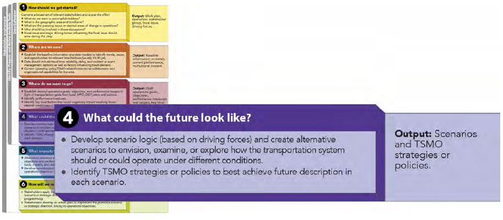 Figure 9. Diagram. Phase 4 of the Federal Highway Administration Scenario Planning Framework Adapted to Transportation Systems Management and Operations. The development of the scenarios during this phase is the most critical piece of the scenario planning approach and will likely require the most effort of any phase. Before creating the scenarios, it is important to keep in mind that the resulting set of scenarios should:
This section will take the reader step-by-step through the development of a set of scenarios. These steps developed by Peter Schwartz in The Art of the Long View complement the FHWA scenario planning framework, and expand upon Phase 4's scenario development task.22 Sample Driving Forces for Exploratory TSMO Scenarios Rise in Oil Prices may lead to greater use of car sharing programs or reduced travel demand. Climate Change may lead to an increase in evacuations and need for alternative routes in cases of flooding. An Influx of Millennials who do not own vehicles into urban centers may lead to greater demand for transit, walking, and bicycling. Move toward Connected Cities may lead to greater opportunities to support travel on demand regardless of mode. Connected and Autonomous Vehicles may have major impacts on all traffic management activities including traffic incident management, access management, and intersection control. Step 1. Identify Focal Issue.23 This is the central question (identified in Phase 1) to be answered. For example, "How should this corridor function in the region?" or "How do we improve the reliability of the region's arterial network?" or "What TSMO strategies should we use to improve system performance under different extreme weather events?" During this phase, the scenario planning leaders should confirm the central question with the stakeholders and see if any revisions are needed based on the work in Phases 2 and 3. Step 2. Identify Key Local Factors. These are the factors that influence the success of addressing the focal issue. They can be considered key influencing factors and they typically relate to the stakeholders of the scenario planning effort. These should be considered when creating the details of the scenarios. For example, a key local factor could be that hurricane evacuations in the region have been under intense scrutiny ever since a difficult evacuation in the past year. Another key local factor could be the available funding for transportation operations or a push by a prominent organization for cleaner transportation alternatives. Key local factors should be identified from the discussions in Phases 2 and 3, where relevant contextual information is gathered and stakeholder goals and objectives are voiced and debated. It will be helpful during this phase to confirm the local factors with stakeholders. Step 3. Identify Driving Forces. These are the major and typically high-level influences on the focal issue that are not controlled by those involved in the scenario planning. This includes uncertain trends or events such as climate changes, gas prices, unemployment levels, or terrorist attacks. Uncertainty as a driving force is particularly true in the exploratory typology of scenario planning. In the normative or predictive typologies, driving forces are likely to include differing priorities or opposing visions for the operation of a transportation system or facility. The driving forces should surface in Phase 1 of the scenario planning process during the discussion of pressing issues and then be further specified in Phases 2 and 3 during the discussion of contextual information, goals, and operations objectives. Step 4. Rank Driving Forces by Importance and Uncertainty. During this step, the scenario planning leaders and stakeholder prioritize the driving forces by importance and, in the case of exploratory scenario planning, uncertainty. This activity is critical to identifying those forces that will shape the scenarios. Those forces that are both highly important and uncertain should be considered as drivers for developing the scenarios. The driving forces may be identified from a range of factors that impact transportation outcomes: social, technological, economic, environmental, and political.24 Step 5. Select Scenario Logic. This is the step that specifies the rationale and structure for how the scenarios will be built. The "scenario logic" is the set of the most important driving forces and the different values those forces will take in the scenarios. For instance, Table 4 shows the simple scenario logic for a scenario planning effort that aims to prepare TSMO activities and programs for the impacts of climate change. In this example, there are two driving forces whose impacts vary by frequency.
Step 6. Flesh Out the Scenarios. In this last step of scenario creation, less critical factors and local influences are used to expand the scenario descriptions so that they are more realistic and contain crucial information on how other important factors or influences come to fruition or fade away in the future. The scenarios should be plausible and internally consistent once they are finished. Following the development of the scenarios, management and operations experts must identify the TSMO strategies that are necessary to optimize the goals for each potential future. Adequate detail is needed to analyze the potential costs and strategy impacts on the identified performance measures. Once a broad set of scenario stories are established and some specific goals and objectives are identified, different packages of TSMO strategies can be created. Depending on the nature of the scenario approach or process, these could be system-wide strategies or corridor-specific strategies. In the case of longer term scenario planning for operations, the set of TSMO strategies should reflect some notion of a tiered timeline as noted in Figure 6. Phase 5. What Impacts Will Scenarios Have?Once strategies are identified for each scenario, analysis and modeling should be conducted to the extent possible to quantify the relative benefits or impacts of those different strategies on achieving near-term and long-term objectives. The analysis can be conducted using a combination of scenario-planning tools combined with either data inputs and outputs or assumptions garnered from sketch-planning tools focused on TSMO, such as the Tool for Operations Benefit Cost Analysis (TOPS-BC) developed by FHWA.25 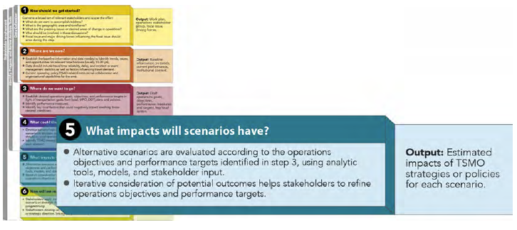 Figure 10. Diagram. Phase 5 of the Federal Highway Administration Scenario Planning Framework Adapted to Transportation Systems Management and Operations. The scenarios are also assessed against the other, broader goals of the region or area of focus: travel options, air quality, economy, commerce, and safety. During this step, the stakeholders are engaged to provide qualitative assessment information with regard to the goals to supplement and consider the quantitative outputs that are available, which will also include discussions of the relative costs and benefits of the sets of strategies considered. It is during this evaluation phase that the tradeoff discussions concerning different strategies and objectives will occur. Based on the evaluation of the scenarios' estimated effects on the performance metrics of interest and in reaching the operations objectives, the TSMO planners and stakeholders can go back and refine the operations objectives to more realistically match potential outcomes. Following this work, the participants in the process should collaboratively decide on a preferred scenario or set of strategies from multiple scenarios that can be used for guiding operations-related planning and, ultimately, project selection and investment decisions. Phase 6. How Will We Reach Our Desired Future?Once there is consensus on a preferred scenario or set of strategies, the TSMO planners should develop the more detailed plans and packages of strategies that will serve as the basis for a corridor or network operations plan. This should include work to create an action plan for actualizing the scenario in terms of new projects and investments, policy changes, institutional arrangements, and a plan for measuring progress. The scenario planning process will help planners and operators hone in on the key performance measures and objectives that will drive the final planning and implementation process. It is those same measures and objectives that will also inform regular monitoring of advances toward meeting short-term and long-term objectives. 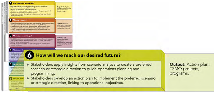 Figure 11. Diagram. Phase 6 of the Federal Highway Administration Scenario Planning Framework Adapted to Transportation Systems Management and Operations. Analysis Tools and Data to Support Scenario Planning for Transportation Systems Management and OperationsAnalytical tools, models, and archived data provide an important foundation to support scenario planning. Analytics, visualizations, and the underlying data are critical in presenting the stories in scenarios and highlighting the key variables or differences between different futures. Baseline data is needed to answer the "where are we now" question in Phase 2 of the scenario planning process. The purpose of analytics in scenario testing is to support the development of plausible future conditions and illustrate the key features and performance of each scenario so that stakeholders can clearly understand the differences and impacts between them. Analysis and visualization tools to support scenario planning for TSMO are really no different than the array of tools used to conduct traditional travel analysis. The data development and analysis steps should be calibrated to help inform the decisionmaking process. Tools relevant for scenario planning in the context of TSMO can be obtained from the suite of tools used for transportation system planning, policy, implementation, and operations analyses. In general, all transportation analysis tools follow a general flow of information and analysis explaining how:
The analytical framework for transportation varies most often to reflect different geographic scales and time horizons (e.g., from regional econometrics explained on an annual or quarterly scale through block-level travel behavior for typical lane-specific data assessed on a minute-by-minute basis). The relationships between travel behavior, travel demand, and system operations can be examined and explored through scenario planning processes. For example, when and how to implement value pricing by time of day or level of demand, by geographic location (e.g., a cordon pricing tool), and by travel market (e.g., comparing HOT lanes to Express Toll Lanes or influencing freight flows by axle or weigh-in-motion pricing) will have a significant impact on travel behavior and vice versa. The selection of an analytical framework and tools to support scenario planning for TSMO should be derived from the key questions and driving forces identified in the early scoping efforts. Developing the analytical framework requires the selection of tools most appropriate for the scale at which measures of effectiveness are desired and the appropriate feedback loop can be assessed. The choice of tools and level of analysis should also reflect consideration of the time and effort required to develop baseline information and create plausible future conditions. TSMO planners may find it helpful to access empirical research and other information to develop some key assumptions about hypothetical future conditions as it relates to traveler behavior, climate change, autonomous vehicles, or other factors. Being transparent and documenting those key assumptions and sharing them with stakeholders is an important step in building confidence in the validity of scenario comparisons and tradeoff discussions. There may also be some limitations with the current palette of tools available to support scenario planning and analysis within a TSMO context. In particular, there are few standard methodologies for developing future forecasts for performance metrics related to TSMO, such as reliability. Also, the current set of tools supporting travel demand analysis does not yet adequately reflect sensitivity to the influences of development patterns and infrastructure design on multimodal traveler behavior. Therefore, for any given TSMO scenario planning effort, there may be a need for new and creative approaches to utilizing existing data and tools to serve the scenario planning process. Given the history of scenario planning in transportation, many of the common transportation scenario planning tools focus on estimating and comparing the effects that different land-use scenarios have on transportation (and vice versa), as well as on performance metrics related to the economy, environment, and other outcomes. Over the last decade several stand-alone software packages have emerged and are available to practitioners to simplify the process of developing and comparing land use scenarios across a broad range of performance metrics. Some of the more commonly used land use planning tools include software packages such as CommunityViz, Envision, and the Land Use and Transportation Scenario Analysis and Microsimulation (LUTSAM) Tool. While these tools can be helpful to TSMO-based planning efforts that seek to examine different travel demand dynamics influenced by the built environment, this suite of tools will likely need to be supplemented to incorporate more common TSMO measures of effectiveness. The primary goal of the analytical framework for scenario testing is to demonstrate how various factors affect overall outcomes—whether or not desirable outcomes can be attained. This testing can illuminate the effects different variables have on travel outcomes within and between scenarios. A multi-scenario method may be developed and applied on top of any of the traditional analysis tools so as to evaluate TSMO strategies in several different conditions. Weather conditions, incidents, work zones, and other system variations may be represented by altering baseline conditions.26 Multiscenario methods have been incorporated into advanced analysis, modeling, and simulation systems to evaluate integrated corridor management (ICM) approaches on reliability metrics. Travel demand models may be most applicable to TSMO scenario planning efforts at the regional level where analysis results are focused on evaluating how different economic, land-use, and demographic variables may influence travel demand and thereby influence system-level TSMO strategies. For instance, if one of the key questions driving the scenario development is the potential impact of long-term changes in travel behavior of aging populations and millennials, then the use of a travel demand model complemented by additional GIS-based multimodal accessibility analysis may be helpful. Archived operations data can be used to support other analysis methods with input data, calibration, and validation. This information plays an important role in understanding current performance of the transportation system. Simulation models or traffic signal optimization tools may be helpful when looking at a smaller area of influence where scenario testing is being performed at a fine-grained level of detail concerning system operations. For example, a scenario planning process may be desirable to better understand the impacts on vehicular mobility if traffic signals are prioritized to give "green time" to pedestrian and bicycle movements rather than motorized vehicles. The following provides a summary of the different types of tools that may be used to support scenario planning for TSMO. These can vary in purpose, complexity, input and output data, strategies analyzed, expertise required, and cost. The current methods and tools can generally be grouped into the following categories:
Archived Operations DataArchived operations data is data that is collected and stored to support the monitoring and management of the transportation system. This includes traffic, transit, bike, pedestrian, construction, and weather information that is usually collected in real time by ITS and other technologies. The following are some examples:
As mentioned above, archived operations data is plentiful in many regions and can be used in Phase 2: Where Are We Now? to document baseline operational conditions and to identify and report performance issues or needs. This data allows planners to investigate causes of congestion by correlating multiple data sets over time and analyzing event-related traffic flows and weather impacts. In addition, knowing the current level of performance for the transportation area of interest is necessary for setting realistic performance objectives (or targets) in Phase 3: Where Do We Want to Go? This information will also be helpful in identifying the key variables necessary to consider for TSMO when developing future scenarios. Travel Demand ModelsTravel demand models are widely used for estimating changes in mode choice and traffic patterns and volumes due to changes in development levels, demographics, and the transportation system (road and transit). These tools are important in scenario planning for TSMO in screening strategies applied on a regional or corridor scale. They can also supply data to sketch planning tools and simulation models that can further analyze TSMO strategies. The three- and four-step travel demand models are fairly limited in their ability to analyze TSMO strategies or reflect mode choice sensitivity at the urban scale, but activity-based travel demand models can evaluate a wider range of operations-related strategies that may be part of a scenario, including pricing strategies, travel demand management programs, and other TSMO strategies with a detailed network model. Activity-based models require a greater investment of time and resources than traditional travel demand models. Travel demand models can support scenario analysis in Phase 5. What Impacts Will Scenarios Have? as well as help planners and other stakeholders understand future trends identified in Phase 2. Where Are We Now? Sketch Planning ToolsSketch planning tools are often the easiest to use for obtaining a quick, rough estimate of how the TSMO strategies that support a scenario compare in terms of benefits against those strategies of other scenarios. These are low-cost tools that help "sketch" a big picture, but they can be limited when seeking a fine-grained level of analysis. Sketch planning tools provide order of magnitude estimates with minimal input data in support of preliminary screening assessments. The tools are often spreadsheets or simple databases with built-in assumptions derived from empirical research as to the impacts or benefits of applying various strategies. Examples include TOPS-BC, California Life-Cycle Benefit/Cost Analysis Model (Cal B/C), Screening Tool for ITS (SCRITS), and QuickZone. Some sketch planning tools integrate with a travel demand model and provide data post-processing to facilitate the review of TSMO strategies and can also be linked up with visualization modules. Visualization ToolsVisualization tools reflect the broad category of methods that support the creation of maps, three-dimensional (3-D) illustrations, and graphic imagery based products aimed at visually highlighting the differences assumed in each scenario. Depending on the key driving issues, the visualizations may be focused on preparing 3-D graphics to demonstrate imagery of the built form. GIS-based mapping may also be helpful in highlighting different place-based variables of relevance in terms of the location of different transportation solutions, impacts of sea-level rise, variances in travel demand, etc. Visualization methods are most often linked with the outputs of other analytic tools and can be extremely valuable in helping to communicate the key issues to a wide range of stakeholders. Analytical/Deterministic Tools (Highway Capacity Model-based)This category of tools implements the procedures outlined in the HCM. The tools are static in that they predict average operating conditions over a fixed time period (e.g., a 15-minute or 1-hour period) and do not deal with transitions in operations from one system state to another. They are currently used most often to predict capacity, density, speed, delay, and queuing on a variety of transportation facilities. Examples include Highway Capacity Software (HCS) and Traffix. These tools may provide some value to TSMO scenario planning when the geographic scale is small and the desired granularity of operational conditions warrants evaluation at the individual intersection or facility scale to assess the impacts of different traffic control strategies (e.g. uncontrolled, stop-controlled, or signalized intersections). Outputs associated with different scenarios could be fed into the HCM model to evaluate relative impacts and sensitivity to different conditions. Simulation ModelsThis category of tools represents transportation system operations by using a variety of formulas and algorithms to simulate travel behavior. They can be applied to isolated locations, corridors, and area-wide conditions. Many include environmental outputs (e.g., emissions) and some models now also include multimodal considerations. Simulation models generally fall within three different categories:
These models are typically used to evaluate a range of improvements and strategies at local or corridor levels. They can be used to test variability in traffic demand or incident severity and also include visualization. These tools may be helpful in scenario testing; however, they do require specialized expertise and software, which can increase the level of effort and cost associated with the testing. Traffic Signal Optimization ToolsSimilar to analytical/deterministic tools, traffic optimization tool methodologies are mostly based on the HCM procedures and are used to analyze delay and identify optimum signal phasing and timing plans for isolated intersections, arterial streets, or signal networks. They may include capacity calculations; cycle length; splits optimization, including left turns; and coordination/offset plans. The type of signal optimization tool used is best determined based on the goal of the traffic signal timing study, network conditions, and data availability. Similarly, these tools may prove valuable during the scenario testing phase if the focus of the problem warrants this level of detail. Any of the tools described above may be utilized to respond to the questions unique to the TSMO environment, with a more micro-scale approach appropriate for TSMO project applications and a macro-scale approach applied for TSMO policy and planning considerations. For example:
As with any analytical framework to support transportation decisionmaking, the key is to select the right tool for the problem at hand and give thought to the level of effort, resources, and time available. 21 U.S. Department of Transportation, Federal Highway Administration, Scenario Planning Guidebook, 2011. Available at: https://www.fhwa.dot.gov/planning/scenario_and_visualization/scenario_planning/scenario_planning_guidebook/. Return to note 21. 22 Peter Schwartz, The Art of the Long View (New York, NY: Currency Doubleday, 1991). Return to note 22. 23 Ibid. Return to note 23. 24 Ibid. Return to note 24. 25 U.S. Department of Transportation, Federal Highway Administration, "Tool for Operations Benefit Cost Analysis (TOPS-BC)", Web site. Available at: https://ops.fhwa.dot.gov/plan4ops/topsbctool/index.htm. Return to note 25. 26 A. Vandervalk, H. Louch, J. Guerre, and R. Margiotta, Incorporating Reliability Performance Measures into the Transportation Planning and Programming Processes: Technical Reference, Transportation Research Board of the National Academies, Project S2-L05-RR-3 (Washington, DC: TRB: 2014). Available at: http://www.trb.org/Main/Blurbs/168856.aspx. Return to note 26. | ||||||||||||||||||||||||
|
United States Department of Transportation - Federal Highway Administration |
||