Border-Wide Assessment of Intelligent Transportation System (ITS) Technology—Current and Future Concepts
Final Report
CHAPTER 4. TRANSPORTATION OPERATIONS AND TRAFFIC MANAGEMENT AND ENFORCEMENT
Transportation Operations
Several regions along the U.S.-Mexico border need to maximize the efficiency of transportation operations at their international border crossings using traditional as well as advanced technology, including ITS. The objective of this chapter is to research, assess, and document the current state of use of ITS technologies and operational concepts by agencies on the U.S.-Mexico and U.S.-Canada borders to improve traffic management and transportation management around the border crossings.
This chapter describes bi-national coordination and identifies where there are possibilities for coordination between agencies across the border in support of traffic management and operation around the border crossings. As an example, a list of technologies deployed at various border crossings along the U.S.-Mexico and U.S.-Canada borders was compiled on a separate project. The information obtained from the literature review was updated through interviews with the stakeholder agencies.
Level of Data Sharing and Integration with Mexican Partners
Review of regional U.S. ITS architectures provides significant insight into how individual regions prioritize information sharing with Mexican agencies. Based on a brief overview of regional ITS architectures from the U.S. side, it is clear that stakeholders from individual regions have placed different priorities on interfacing with Mexican counterpart agencies. For example, Laredo’s ITS architecture does not include stakeholders from Mexico, while Pharr’s ITS architecture includes Mexican emergency management agencies (EMAs) as a stakeholder group and interfaces with TMCs operated in the Pharr region—even though none exist at present. New Mexico’s statewide architecture mentions interfaces with New Mexico Department of Transportation (NMDOT) District 1 (Las Cruces region) with a Mexican regional TMC. Analysis of inconsistencies between regional ITS architectures regarding information sharing with Mexican agencies should be investigated.
The literature review and interviews with officials on both sides of the border revealed that sharing of real-time traffic management data between agencies from both sides of the U.S.-Mexico border has been limited. Compared to Canadian agencies on the U.S.-Canada border, Mexican counterparts on the U.S.-Mexico border have only to a very limited degree deployed ITS with the specific purpose of incident management around border crossings. In addition, none of the cities on the Mexican side of the border has deployed TMCs to manage and operate transportation systems including border crossings. TMCs are a crucial platform for sharing information between regions. However, conversations with officials mentioned that there has been little or no progress in U.S. agencies sharing their TMC data with agencies in Mexico.
This may change in the future. Secretaría de Comunicaciones y Transportes (SCT) is planning to deploy several TMCs in the border region. SCT is going ahead with construction of regional TMCs in the cities of Monterrey and Chihuahua. The TMCs will monitor Mexican federal roadways and toll roads, many of which terminate at international border crossings. These TMCs will be able to operate ITS field devices deployed on roadways close to border crossings and provide ATI, which will include traffic conditions on roadways as well as border crossings (48). In addition, the ITS system envisioned by SCT includes TMCs to be operated by toll concessionaires that will share real-time data with TMCs on the U.S. side of the border (49).
Interviews with officials revealed that agencies from both sides of the border make requests for assistance while responding to disasters. In the absence of TMCs, communication among agencies on both sides of the border is limited to methods such as radio and mobile phones. It is important to keep in mind that requests for information/assistance between the two countries happen at the city level and not county or State level (50). Thus, data sharing among cross-border agencies should happen at the local level because of the immediate need to respond to incidents and emergencies and the fact that local enforcement agencies are the first ones to respond.
Regions in the United States have adopted a consistent set of standards for information exchange. A recommended list of standards can be found in a report prepared by the National ITS Architecture Team for the recent Border Wait-Time Project on the U.S.-Canada border. The standards come from the National ITS Architectures of both the United States and Canada. Table 8 displays a list of candidate ITS standards for the Border Wait-Time Project, including Lead Standards Developing Organization (SDOs).
| Lead SDO | Standard Name |
|---|---|
| AASHTO/ITE | Traffic Management Data Dictionary (TMDD) and Message Sets for External TMC Communications |
| AASHTO/ITE/NEMA | National Transportation Communications for ITS Protocol (NTCIP) Center-to-Center Standards Group |
| AASHTO/ITE/NEMA | NTCIP Center-to-Field Standards Group |
| AASHTO/ITE/NEMA | Global Object Definitions |
| AASHTO/ITE/NEMA | Object Definitions for Closed Circuit Television Camera (CCTV) Control |
| AASHTO/ITE/NEMA | Object Definitions for Data Collection and Monitoring Devices |
| AASHTO/ITE/NEMA | Object Definitions for Closed Circuit Television Switching |
| AASHTO/ITE/NEMA | Data Element Definitions for Transportation Sensor Systems |
| ASTM | Standard Practice for Metadata to Support Archived Data Management Systems |
Note: ITE: Institute for Transportation Engineers, AASHTO: American Association of State Highway Transportation Officials, NEMA: National Electrical Manufacturers Association, ASTM: American Society for Testing and Materials
Source: (51).
An efficient bi-national data exchange can only take place if agencies on both sides of the border follow common standards whether the exchange takes place between centers or field devices. The SCT recently finalized the National ITS Strategic Plan, which includes planning, development, and implementation strategies for ITS at the national, regional, and local levels. Other studies include developing and updating ITS processes, standards, and protocols. The objective of the study was to use this result to promote ITS system implementation and interoperable applications at the local and regional levels. The project will ensure software and hardware consistency, interconnectivity, and compatibility. It will define the institutional structure needed to supervise the implementation of the Mexican National ITS Strategic Plan.
Different levels of adoption of current ITS standards by both countries (and regions across the border) will most likely hinder exchange of real-time traffic data. It remains to be seen how ongoing and future projects (discussed in chapter 6) plan and implement real-time data exchange between agencies (rather than TMCs) in both countries.
Technology Used for Inspecting, Weighing, and Screening to Increase Efficiency
Several Border States are implementing technologies to increase efficiency at border crossings. The Arizona Department of Transportation (ADOT implemented a project called Expedited Processing at International Crossings (EPIC), which combined proven ITS technologies to expedite processing, compliance monitoring, and traffic management, at the Nogales POE in 1998. EPIC’s features included the slow weigh-in-motion (SWIM) system, CCTV monitoring, AVI, VMSs, digital imaging equipment, future installation of thermal imaging for safety-related issues, and USDOT number readers sending data to the database system for storage and integration of information from all of the technologies, communications systems, and ancillary equipment. EPIC also provided a means to access and update information from motor carrier service records. Currently, ADOT is coordinating the implementation of EPIC III with their commercial vehicle border crossing time and wait-time measurement projects.
The Department of Public Safety (DPS) in Texas and the California Highway Patrol (CHP) in California operate border vehicle safety inspection facilities (BSIFs). The Texas DPS, working with the Texas Department of Transportation (TxDOT), is implementing an RFID-based system to monitor inspection times inside the BSIF and also to identify carriers that should not bypass the inspection process based on their safety records. The system is similar to the FAST system but is based on information from the carrier’s safety records. This system is being implemented at the Bridge of the Americas in El Paso and is not fully deployed yet.
The BSIFs in Texas and California have weigh-in-motion (WIM) systems that identify overweight vehicles as they enter the vehicle safety inspection stations. Commercial vehicle weight regulations in Mexico and Canada are different from those the U.S. Rules and regulations for the two U.S. NAFTA trading partners allow for heavier trucks; therefore, it is important to verify that trucks coming into the United States comply with local standards. WIM border data are currently not being shared or archived.
Technology Being Deployed or Proposed to Improve Border-Crossing Time by CBP
CBP’s dual mission is to secure the nation’s borders while facilitating legitimate trade and travel. CBP enforces a number of trade laws and protects domestic industry by applying quota and visa restrictions. These different security and economic aspects that CBP needs to enforce can be divided into three types of inspections at land POEs:
- Immigration inspections: These inspections enforce immigration laws and focus on keeping aliens who violate any of the laws from entering the country.
- Customs inspections: These inspections have the purpose of controlling the import and export flows of the United States, collecting the necessary revenues, and preventing the smuggling of illicit goods.
- Agriculture inspections: These inspections are meant to ensure a safe and affordable food supply.
CBP has implemented a variety of technologies at land POEs, and the most recent implementation is part of the WHTI. Other technologies for scanning were implemented as part of the trusted-traveler programs for commercial and passenger vehicles (FAST and SENTRI). Table 9 and Figure 6 present technologies that currently are in operation at the federal compounds at land POEs. Table 9 includes information on the stages of the process and the programs under which these technologies operate.
| Land POE Technology | Ped. Pre-screening | POV pre-screening | CV pre-screening | Ped. Primary | POV Primary | CV Primary | Ped. Secondary | POV Secondary | CV Secondary | FAST program | NEXUS program | SENTRI program | US-VISIT program | RPM program |
|---|---|---|---|---|---|---|---|---|---|---|---|---|---|---|
| Closed-circuit television (CCTV) | Yes | Yes | Yes | Yes | Yes | Yes | Yes | Yes | Yes | No | No | No | No | No |
| Data mining | Yes | Yes | Yes | Yes | Yes | Yes | Yes | Yes | Yes | No | No | No | No | No |
| Explosive Detection Systems | No | No | No | Yes | Yes | Yes | Yes | Yes | Yes | No | No | No | No | No |
| Fingerprint Recognition | No | No | No | No | No | No | No | No | No | No | No | No | Yes | No |
| K-9 Unit | Yes | Yes | Yes | No | No | No | Yes | Yes | Yes | No | No | No | No | No |
| License Plate Reader (LPR) | No | Yes | Yes | No | No | No | No | No | No | No | No | No | No | No |
| Passport Readers | No | No | No | Yes | Yes | Yes | No | No | No | Yes | Yes | Yes | No | No |
| Proximity Cards | No | No | No | Yes | Yes | Yes | No | No | No | Yes | Yes | Yes | No | No |
| Fixed Gamma-ray imaging | No | No | No | Yes | No | No | No | No | No | No | No | No | No | No |
| Mobile Gamma-ray imaging | No | No | No | No | No | No | No | No | No | No | No | No | No | No |
| Vehicle Tags Radio-frequency Identification (RFID) | No | Yes | Yes | No | No | No | No | No | No | Yes | Yes | Yes | No | No |
| ID Cards RFID | No | No | No | Yes | Yes | Yes | No | No | No | Yes | Yes | Yes | No | No |
| Fixed Radiation Portal Monitor (RPM) | Yes | Yes | Yes | No | No | No | No | Yes | Yes | No | No | No | No | Yes |
| Portable RPM | Yes | Yes | Yes | No | No | No | No | Yes | Yes | No | No | No | No | Yes |
| Fixed X-ray Imaging | No | No | No | Yes | No | No | No | Yes | Yes | No | No | No | No | No |
| Mobile X-ray Imaging | No | No | No | No | No | No | No | No | Yes | No | No | No | No | No |
| Advanced Backscatter X-ray Imaging | No | No | No | No | No | No | No | Yes | Yes | No | No | No | No | No |
*Advanced backscatter x-ray imaging is an emerging technology that is being implemented on a limited basis at certain land POEs.
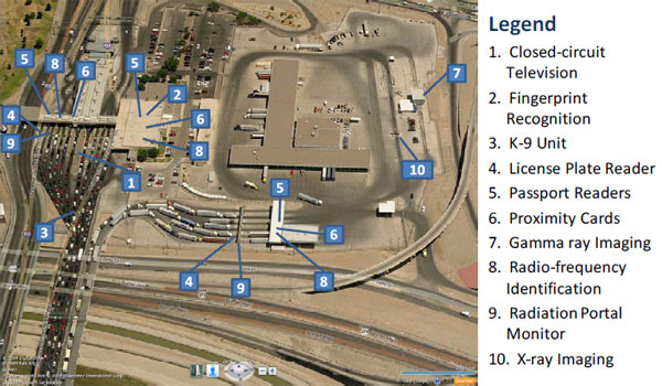
Figure 6. Photograph depicting technologies implemented at the CBP compound in the Bridge of the Americas.
Planned Special Events at and around Border Crossings
Federal, State, and local agencies play a significant role in planning and responding to planned special events (PSEs) that impact operation of border crossings and the surrounding areas. PSEs include visits to the border by high-profile individuals, major cultural and sporting events, major holidays (e.g., Easter and Christmas) that draw huge cross-border shopping trips, large cross-border cattle movements, and introduction of new identification requirements to cross the border. While none of these events requires closing the POE, one may severely increase the wait times of passenger vehicles entering the United States.
Based on the interviews conducted with the stakeholder agencies of the border regions, such events are planned ahead using ad-hoc meetings among agencies of all levels (53). Table 10 lists agencies and their roles, methods of communication, and ITS use at different border regions. Each agency then lays out its subsequent roles according to its jurisdictions to assist traffic management during the event. In most cities, even if the roadways are State maintained, they may be operated by the cities. In such cases, local law enforcement agencies respond to incidents around border crossings. One major difference between the U.S.-Canada and U.S.-Mexico borders is that most major border crossings on the U.S.-Mexico border are situated in the middle of urban centers (often downtowns and central business districts) on both sides of the border. Hence, local law enforcement agencies are expected to be significantly involved while planning and managing special events around border crossings.
While responding to the event, agencies with access to ITS field devices use such devices to monitor the progression of traffic around border crossings. However, none of the border regions has developed a centralized information system through which communication and data sharing could occur between the agencies to monitor the progression of traffic during the event. Communication among agencies on both sides of the border is limited to methods such as radio communication and mobile phones.
| Border Region | Agencies and Their Roles in Managing Planned Special Events | Method of Communication | Use of ITS to Inform Motorists |
|---|---|---|---|
| Laredo – Nuevo Laredo | Webb and Hidalgo County Metropolitan Planning Organization (MPO), Nuevo Laredo, City of Laredo, police and fire departments, TxDOT, Mayor’s Office from both cities across the border, CBP, EPA, and DPS. City of Laredo/Hidalgo County MPO coordinates the meetings to plan for a special event and brings rest of the agencies together. Each agency then lays out its subsequent role(s) according to its jurisdiction to assist traffic management during the event. |
While responding to an event, agencies on the U.S. side use ITS field devices but do not have centralized information systems in place through which communication and data sharing could occur among the agencies to monitor the progression of traffic during the event. | Mostly limited to display of information via fixed VMSs on the U.S. side only, and press releases carried through local media. |
| El Paso – Ciudad Juarez | El Paso MPO, Ciudad Juarez, City of El Paso, police and fire departments, TxDOT, IMIP, Mayor’s Office from both cities across the border, CBP, EPA, and DPS. El Paso MPO coordinates the meetings to plan for a special event and brings rest of the agencies together. Each agency then lays out its subsequent role(s) according to its jurisdiction to assist traffic management during the event. |
While responding to an event, agencies use ITS field devices on the U.S. side but do not have centralized information systems in place through which communication and data sharing could occur among the agencies to monitor the progression of traffic during the event. | Mostly limited to display of information via fixed VMSs on the U.S. side, and press releases carried through local media. |
| Santa Teresa – Ciudad Juarez | New Mexico Border Authority (NMBA), City of Sunland Park, City of Las Cruces, Ciudad Juarez, police and fire departments, NMDOT, Mayor’s Office from both cities across the border, CBP, EPA, DPS. NMBA coordinates the meetings to plan for a special event and brings rest of the agencies together. Each agency then lays out its subsequent role(s) according to its jurisdictions to assist traffic management during the event. |
Mostly limited to face-to-face meetings and telephone calls. | Press releases carried through local media. |
Note: EPA = Environmental Protection Agency, IMIP = Metropolitan Planning Agency of Ciudad Juarez, NMBA = New Mexico Border Authority.
Real-Time Incident Management at and around Border Crossings
State and local agencies play a significant role in responding to incidents around border crossings. Individual roles of these agencies depend on the presence of State and/or local roadways that lead to and from the border crossings and their current jurisdictions for traffic operation on these roadways. In most cities, even if the roadways are State-maintained, they may be operated by the cities. In such cases, local law enforcement agencies respond to incidents around border crossings. One major difference between the U.S.-Canada and U.S.-Mexico borders is that most major border crossings on the U.S.-Mexico border are situated in the middle of urban centers (often downtowns and central business districts) on both sides of the border. Hence, local law enforcement agencies are much more involved during incident management on the U.S.-Mexico border, while State and county agencies play a much bigger role on the U.S.-Canada border.
While local police and fire departments respond to all incidents, local fire departments have a much bigger role in responding to hazardous materials (HAZMAT)-related incidents. Local fire departments are trained to contain HAZMAT spills. Given the circumstances of the spill and nature of the HAZMAT, the EPA and regional emergency management may be called upon to contain the incident.
All the border State DOTs at the U.S.-Mexico border operate TMCs with significant investments in ITS for incident management. Compared to agencies on the U.S.-Canada border, their counterparts on the U.S.-Mexico border have deployed ITS only to a very limited degree with the specific purpose of incident management around border crossings. Table 11 describes roles and responsibilities of local, State, and Federal agencies on both sides of the border for real-time incident management.
| Agency | Description of Roles and Responsibilities | Access to ITS |
|---|---|---|
| U.S. and Mexican County or Municipal Public Safety Agencies | These agencies are responsible for law enforcement and first response and include city or county police departments, fire, and ambulance services; sheriff’s departments; and State police. Fire departments are de-facto response agencies for HAZMAT-related incidents at and around border crossings. | Cities on the U.S. side of the border have agreements with State DOTs to access ITS field devices. |
| U.S. State Department of Public Safety/Highway Patrol | State Department of Public Safety (in TX, NM, and AZ) and the Highway Patrol (in CA) manage incidents on State highways in the United States. | State DPS and Highway Patrol have agreements with State DOTs to access ITS field devices. |
| U.S. State DOTs | State DOTs are responsible for managing, operating, and/or maintaining State-owned transportation infrastructure around border crossings. Services provided include advanced traffic management, traveler information, and other services. | State DOTs own and operate a wide range of ITS field devices for incident management. |
| Mexican Army | The Mexican Army inspects trucks entering the U.S. for narcotics and illegal goods. | None |
| U.S. and Mexican Federal Law Enforcement | Federal law enforcement agencies respond to major incidents at and around border crossings. | None |
| U.S. and Mexican Toll Authorities | These agencies include Government agencies (and could include public-private arrangements) responsible for the administration, operation, and maintenance of bridges, tunnels, turnpikes, and other fee-based roadways. They help local police and fire departments. | Agencies are equipped with CCTVs and VMSs on their facilities and use them to monitor toll violators; if needed, field devices can be used for traffic management. |
| U.S. EMAs | These include county and State agencies that coordinate overall response to large-scale incidents or major disasters. These agencies have mandates to set up emergency operations centers to respond to and recover from natural, manmade, and war-caused emergencies, and for assisting local governments in their emergency preparedness, response, and recovery efforts. | EMAs coordinate with State DOTs to access ITS field devices during incident response. |
| Mexican EMAs | These EMAs are in charge of dispatching police, medical, and firefighter units in Ciudad Juarez, Mexico. Anyone can call this number to report all kinds of incidents including HAZMAT incidents. | The agency uses the same technology as the one used by the 9-1-1 system in the United States. The only difference is that the agency can identify the location of nearest field unit using GPS devices. |
| U.S. EPA | EPA call center will assist with basic containment and call an EPA contractor that is specially trained to respond and contain specific HAZMAT problems. Local law enforcement will assist with the HAZMAT containment along with local fire department. | State DOTs and/or city police and fire departments assist the EPA with traffic management activities during HAZMAT incidents, but EPA does not have access to ITS field devices. |
Table 12 describes how various border regions manage incidents and how motorists are provided with incident-related information.
| Border Region | Agencies and Their Roles in Managing Incidents | Method of Communication | Use of ITS to Inform Motorists |
|---|---|---|---|
| Laredo-Nuevo Laredo | City of Laredo, Nuevo Laredo, police departments, fire departments, TxDOT, CBP, and EPA. Because all the border crossings are within the city limits, police and fire departments have jurisdictions to respond to incidents around the border crossings. CBP responds to all incidents within its compound and occasionally requests assistance from the local fire department and EPA to respond to HAZMAT-related incidents within the CBP compound. |
During the event, there are no information systems in place through which communication and data sharing could occur between agencies on both sides of the border to monitor the progression of traffic during the incident. U.S. agencies such as TxDOT, police departments, and fire departments do, however, exchange information via very high frequency (VHF) radio and have access to CCTV cameras installed by TxDOT on State roadways. | Mostly limited to relay of information via fixed DMSs, and local media in the United States. |
| El Paso-Ciudad Juarez | City of El Paso, Ciudad Juarez, City of Sunland Park, police departments, fire departments, TxDOT, CBP, EPA. Because all the border crossings are within the city limits, police and fire departments have jurisdictions to respond to incidents around the border crossings. While CBP responds to all incidents within its compound, it occasionally requests assistance from the fire departments and EPA to respond to HAZMAT-related incidents within the CBP compound. |
During the event, there are no information systems in place through which communication and data sharing could occur between agencies on both sides of the border to monitor the progression of traffic during the incident. U.S. agencies such as TxDOT, police departments, and fire departments do, however, exchange information via VHF radio and have access to CCTV cameras installed by TxDOT on State roadways. | Mostly limited to relay of information via fixed dynamic message signs, and local media in the United States. |
| Santa Teresa- Ciudad Juarez | Highway Patrol is the major agency responsible for managing incidents around border crossings, since none of them is within city limits, except for City of Columbus. | During the event, there are no information systems in place through which communication and data sharing could occur between agencies on both sides of the border to monitor the progression of traffic during the incident. U.S. agencies such as the Highway Patrol and fire departments do, however, exchange information via VHF radio. There are no CCTV cameras deployed close to border crossings. | There are no VMS signs close to border crossings. Hence, incidents are relayed through the 5-1-1 system in the U.S. |
Along the U.S.-Mexico border areas, many cities have signed sister city agreements. Many of these agreements were inspired by the U.S. and Mexico Border 2012 Program. The cities of Laredo and Nuevo Laredo developed a cross-border contingency plan in 1998 as part of a sister city agreement to allow either city to utilize resources and manpower essential to respond to emergencies and disasters within the two Federal boundaries (56). A similar bi-national emergency plan (focused on HAZMAT) was signed in 2007 among the City of El Paso, Ciudad Juarez, and the City of Sunland Park under the 14th border sister city agreement (57). The plan calls for police, fire, paramedics, and other emergency response personnel from both sides of the border to respond quickly to large fires, dangerous chemical spills, or other emergencies. In 2000, the border cities of Nogales, Arizona and Sonora also signed a bi-national prevention and emergency response plan to improve their ability to prevent and respond to fire, chemical, and/or HAZMAT emergencies (58).
However, due to liability issues associated with the risk of responding to a HAZMAT incident on the other side of the border, fire departments on the U.S. side are not allowed to cross into Mexico and directly respond to HAZMAT incidents (54). For example, one of the most important liability issues is disability insurance. Insurance companies in the U.S. will neither recognize nor pay disability to U.S. fire station personnel if they are injured when responding to an incident in Mexico.
This dilemma might be changing soon because authorities are trying to mandate disability coverage regardless of where an accident or disability occurs. However, no authority will risk predicting the outcome. In spite of these hurdles, the cities of El Paso and Sunland Park on the U.S. side maintain a close relationship with colleagues from Ciudad Juarez and provide frequent training in HAZMAT response. There are existing information-sharing agreements, some of which are formalized and some of which are informal. For example, the El Paso Fire Department has close ties with counterparts in Ciudad Juarez and communicates with fire stations from the other side of the border via telephone calls in case of a HAZMAT incident.
Disaster Preparedness, Response, and Recovery
About 5,000 tons of HAZMAT worth over $4 billion dollars was exported to Mexico in 2002. The U.S.-Mexico border region experiences a concentrated flow of HAZMAT. On the Mexican side, 2,600 manufacturing plants use and/or produce an enormous amount of HAZMAT; the material is then processed at factories in Mexico, the products are shipped around the world, and the remaining HAZMAT is brought back to the United States. Under NAFTA requirements, all HAZMAT that is shipped into Mexico or generated during the manufacturing process must be shipped back to its point of origin, typically the United States. The U.S. side has concentrated areas of storage and disposal facilities. Thus, the delivery and return of HAZMAT has created a HAZMAT transportation corridor.
Fifty percent of the trade that crosses through Laredo involves HAZMAT. Laredo has an enormous potential for a disaster involving HAZMAT due to the volume of HAZMAT cargo and commerce alongside the tourism present on both sides of the border (59). Additionally, Laredo has over 60 million square feet of warehouse space, and at least a quarter of that space contains HAZMAT and is highly vulnerable to terrorism including biochemical terrorism.
The literature review and interviews with officials from border regions revealed that disasters due to HAZMAT are the biggest concern—even bigger than natural disasters.
Border cities along with the counties have formed emergency management offices/centers, which work closely with State and Federal emergency agencies such as the Federal Emergency Management Agency (FEMA) and the U.S. EPA. The purpose of the emergency operations centers (EOCs) is to provide a location where multiple levels of Government, agencies, and organizations can coordinate decisions, resources, and public information on a strategic level. Emergency management centers (EMCs) are also responsible for the development and implementation of emergency plans, training, public outreach—and most importantly—coordination of local, State, and Federal officials while responding to major disasters.
For example, the El Paso County Office of Emergency Management is responsible for developing and implementing plans for the protection of the community and for minimizing the effects of a natural or manmade disaster. The agency is further responsible for designing and directing local emergency exercises, coordinating the activities of local agencies and resources during disaster, coordinating requests for assistance, and providing information to State and Federal agencies during disaster operations. The agency also coordinates with other city and county departments regarding responsibilities during a disaster, compiling and submitting all reports required by the State and Federal agencies. This agency is also responsible for responding to HAZMAT incidents. The agency has defined disasters as incidents that require mass emergency evacuations, natural and manmade disasters, HAZMAT incidents, and border violence incidents.
The agency also provides an emergency notification service that contacts individuals and provides vital information/instructions during a city-wide emergency or disaster. The agency maintains an emergency alert system called EPEMERGENCYALERT.COM and can send alerts to the county residents only. It uses geographic information system (GIS) technology to send alerts to only those target areas.
Similar EMAs exist in all U.S. cities along the U.S.-Mexico border region, as Table 13 shows. All of these agencies, except Mexican agencies and the agencies in Nogales, have capabilities to alert their residents about impending situations.
The cities of Laredo and Nuevo Laredo developed a cross-border contingency plan in 1998 as part of the sister city agreement to allow either city to utilize resources and manpower essential to respond to emergencies and disasters within the two Federal boundaries (56). A similar bi-national emergency plan (focused on HAZMAT) was signed in 2007 between the City of El Paso, Ciudad Juarez, and the City of Sunland Park under the 14th border sister city agreement (58). The plan calls for police, fire, paramedics, and other emergency response personnel from both sides of the border to respond quickly to large fires, dangerous chemical spills, or other emergencies. In 2000, the border cities of Nogales and Arizona-Sonora also signed a bi-national prevention and emergency response plan to improve their ability to prevent and respond to fire, chemical, and/or HAZMAT emergencies (58).
It is obvious from the literature review and interview with officials that despite the need to share information in real time between agencies in Mexico and the United States, none of the agencies has developed such a system. Interviews with officials revealed that agencies from both sides of the border do make requests for assistance in times of disaster. Most of the requests for assistance and coordination still happen through a traditional method of communication—telephones. Even though sister city agreements allow agencies on both sides of the border to utilize communication to share information while planning, responding, and managing HAZMAT incidents in real time, such systems have not been developed due to lack of funds.
| Border Region | Disaster Response Plan | Agencies Involved in Responding | Use of ITS |
|---|---|---|---|
| Laredo-Nuevo Laredo | Yes | City of Laredo, County of Webb, TxDOT | Not available |
| El Paso- Ciudad Juarez | Yes | City of El Paso, El Paso County, TxDOT | El Paso Emergency Alert System run by the City/County of El Paso delivers messages by telephone, text, email, etc. to its residents. The system provides radio operators with all forms of communications as well as provides supplemental communications to the Sheriff's Office. City/County also uses the Web-based Emergency Operations Center (WebEOC) as a crisis information management system and provides secure real-time information sharing among partner agencies. TxDOT relays information to motorists on fixed VMSs about the hazardous conditions. |
| Ciudad Juarez under the direction of Civil Protection | There is no centralized alert system such as El Paso and San Diego have. | ||
| Santa Teresa-Ciudad Juarez | Yes | Dona Ana County | EOC is operated by Luna and Dona Ana Counties. The center communicates with the first responders, but there is no centralized alert system like the ones El Paso and San Diego have. |
| Ciudad Juarez under the direction of Civil Protection | There is no centralized alert system like the ones El Paso and San Diego have. | ||
| Nogales-Nogales | Yes | Pima County, City of Nogales | A system is available for residents of the county to receive alerts via text messages and email (60). Service does not extend to residents across the border. |
| Otay Mesa-Tijuana | Yes | San Diego County and 18 other incorporated cities within the county | San Diego County and other incorporated cities use WebEOC (61). |
Source: (61)
Traffic Management
Technology and State-of-Practice Scan to Measure and Share Border Wait Times and Delay
The CBP and the CBSA are two agencies that measure border wait times and share the information in the public domain. The CBP measures wait times of vehicles inbound to the United States using one of five methods depending on the POE: unaided visual observation, cameras, driver surveys, time-stamped cards, and ALPRs. The CBSA uses similar techniques (62). CAPUFE, the Mexican federal agency that operates the border crossings, does not relay border wait times. Mexican motorists rely on the information relayed by the CBP for such information.
Understanding the shortcomings of the data relayed by the border agencies, the FHWA and TxDOT have deployed several ITS projects. These deployments use RFID technology to measure and relay highly accurate and reliable wait times and crossing times of commercial vehicles. These RFID technology-based systems have already been deployed at the Bridge of the Americas in El Paso, Texas, and the Pharr-Reynosa International Bridge in Pharr, Texas. TxDOT is further deploying similar systems in Laredo and McAllen, Texas. The Arizona Department of Transportation is implementing a similar RFID-based system to measure wait times of trucks at the Mariposa POE in Nogales .
A border wait-time (BWT) work group comprised of the CBP, FHWA, CBSA, and Transport Canada (TC) has been working together to foster the use of technologies for automating the measurement and dissemination of U.S. Canada land border crossing wait time data (51).
The working group is undertaking the Border Wait Time Project, which has the purpose of (a) identifying and evaluating automated, technology based solutions for measuring border wait times, and (b) deploying an automated, technology based solution for measuring border wait times at two border-crossing locations along the U.S.-Canada border.
The initial phase of the project will involve testing of a range of approaches to border wait time determination (e.g., queue length measurement systems, fixed-point vehicle re-identification systems, and dynamic vehicle tracking systems) at two international border crossings:
- Peace Bridge—Buffalo/Niagara Region.
- Pacific Highway—British Columbia/Washington Region.
Later phases of the project will identify solutions that meet functional needs and agency budget limitations and facilitate deployment at all U.S.-Canada international border crossings.
Toll collection agencies and concessionaires on the U.S.-Mexico border continue to use ALPR technology for toll collection and enforcement. However, toll collection agencies mainly deploy ALPR at entrances and exits of bridges or tunnels and may not have incentives to deploy ALPR farther upstream or downstream to measure wait or crossing times. However, use of ALPR to measure and relay wait times or crossing times is nonexistent at POEs on the U.S.-Mexico border.
Some private concessionaires on the U.S.-Canada border use Bluetooth technology to measure crossing times of passenger vehicles, which are then relayed to motorists via Internet and VMSs. However, there are concerns that private concessionaires might be reluctant to accurately report longer wait times if there are competing concessionaires operating in the same region.
Deployment of vehicle detection technology for the purposes of measuring traffic volume and queue length at border crossings is limited. Very few agencies on the U.S.-Canada border have deployed vehicle detectors at border crossings. The Ontario Ministry’s Advanced Traffic Management Section led an initiative to implement an intelligent Queue Warning System (QWS) on Hwy 402 to automatically detect queues and warn motorists in advance of the queue via variable message signs. The system leveraged the experience gained from a similar system previously implemented by ATMS on the Hwy 405 and Queen Elizabeth Way Niagara U.S. border crossing. The system consists of inductive loop detectors to detect vehicle queue, CCTV cameras for queue verification, and flashing beacons and VMSs to warn approaching motorists. Instead of physically connecting camera sites to a TMC, the system uses a long-haul wireless Ethernet system utilizing existing communications towers as repeater sites using 5.8 GHz spread spectrum radio (63).
Volume of vehicles that cross the border is also collected by both CBSA and CBP and is distributed to State DOTs and other agencies in highly aggregated temporal granularity. In addition, agencies operating at the border are also interested in deploying vehicle detectors to count volume of approaching vehicles with hopes of using that information to estimate queue lengths and delay time. Both the Washington State DOT (WSDOT) and British Columbia Ministry of Transportation (BCMoT) have installed inductive loop detectors on roadways approach the Cascade Gateway border crossing. A system maintained by the Whatcom Council of Governments (WCOG) archives the vehicle detector data and provides historical wait time, volume, queue length, and service rate data to regional organizations, agencies, and the public (64).
However, past studies have shown conflicting results in terms of these algorithms being able to accurately estimate queue lengths and wait times. A fundamental problem is that the reliability and accuracy of counting vehicles and speed reduces significantly with increasing density and slow-moving traffic, which is typical at major border crossings.
Table 14 includes a list of border crossings and agencies deploying various ITS technologies to collect data such as volume of approaching vehicles, crossing times, wait times, and queue length.
Vehicle detection technologies are divided into two broad categories—intrusive and non-intrusive. Intrusive detection technologies include inductive loops, which are widely used for a variety of transportation applications. Non-intrusive detection technologies include microwave radar, active radar or laser, and video image processing. Table 15 describes the basic operations theory of an elected few intrusive and non-intrusive vehicle detection technologies, which were chosen in this study due to their widespread use compared to other technologies. Non-intrusive detection technologies have an advantage over intrusive detectors because they do not disrupt traffic flow during installation and maintenance and are highly reliable and flexible. These benefits have encouraged some transportation professionals to replace inductive loop detectors with non-intrusive detectors. Table 16 includes a brief description of strengths and weaknesses of inductive loop, microwave radar, laser, and video image processing-based vehicle detection technologies.
| Location | Proponents | Technology | Direction | Vehicles | Factors Measured | Status |
|---|---|---|---|---|---|---|
| Blaine-Pacific Highway and Douglas (Peace Arch) crossings at the US-Canada border | BCMoT, WSDOT, IBI Group, WCOG, TC, WED | Loop detectors + license plate reader | U.S.-bound and Canada-bound | Cars only, extending to trucks at Northbound Blaine crossing | Volume of vehicles, toll collection | Operational since 2003 |
| Sarnia, Ontario-Port Huron, Michigan | MTO, Delcan, TC | loop detectors | U.S.-bound only | Separate measures for cars and trucks | Volume of vehicles | End of 2008 |
| LaColle, Quebec-Champlain, New York | Tecsult, MTQ, SAAQ, TC | Radar detectors | U.S.-bound only | Mixed traffic | Volume of vehicles | Spring 2008 |
| Buffalo, New York-Niagara Falls, Ontario (three locations) | NYSDOT, NYSTA, MTO, NITTEC | RFID | U.S.-bound and Canada-bound | Mixed traffic, but planning to separate cars and trucks | Crossing times | October 2008 |
| Lynden and Sumas, Washington | WSDOT | License plate readers | Canada-bound only | Cars only | Volume of vehicles, toll collection | Summer 2008 |
| Bluetooth Functionality Test | TC (Ontario), TGT | Bluetooth readers | U.S.-bound and Canada-bound | Cars only | Crossing times | Data collected since late 2006 |
| GPS project at seven locations in Ontario and Quebec | TC (Ontario), TGT, EBTC | GPS logs | U.S.-bound and Canada-bound | Trucks only | Crossing times | Pilot ongoing since Spring 2006 |
| El Paso, Texas-Mexico Bridge of the Americas | FHWA, TTI/ Battelle | RFID | U.S.-bound only | Trucks only | Crossing times and wait times | Operational since 2009 |
| Pharr-Reynosa International Bridge | TxDOT, TTI, City of Pharr | RFID | U.S.-bound only | Trucks only | Crossing times and wait times | Operational since 2009 |
| Mariposa-Nogales POE | ADOT, TTI/ Battelle | RFID | U.S.-bound only | Trucks only | Crossing times and wait times | 2011 |
| San Ysidro, California | Premier Wireless | Video image processing | U.S.-bound only | Cars only | Volume of vehicles, toll collection | Discontinued in 2005 |
| Douglas, Arizona-Mexico | Sentrillion (formally New Technology Management, Inc. or NTMI) | Video image processing | U.S.-bound only | Cars only | Volume of vehicles, toll collection | No longer in operation |
| World Trade and Camino Colombia International Bridges | TTI, TxDOT | RFID | U.S.-bound only | Trucks only | Crossing times | End of 2010 |
| Otay Mesa, California-Mexico | FHWA, Delcan | GPS | U.S.-bound only | Trucks only | Crossing times | Spring/Summer 2008 |
Adapted from: (62)
Note: MTO: Ministry of Transportation of Ontario,MTQ: Ministère des Transports du Quebec, SAAQ: Société de l'assurance automobile du Québec, NYSDOT: New York State Department of Transportation, NYSTA: New York State Thruway Authority, NIITEC: Niagara International Transportation Technology Coalition, TGT: Turnpike Global Technologies, EBTC: Eastern Border Transportation Coalition, NTMI: New Technology Management Inc., WED: Western Economic Diversification Canada
| Technology | Basic Operation Theory |
|---|---|
| Inductive Loops | An inductive loop detector senses the presence of a conductive metal object by inducing electrical currents in the object. The induced current decreases the loop inductance, which is sensed by the inductive loop electronics unit. The electronics unit interprets the decreased inductance as vehicle detection and sends an appropriate call to the controller. |
| Microwave Radar | A microwave radar detectors transmits low-energy microwave radiation at the detection zone, and based on the frequency shift that results from relative motion between a frequency source and a listener, detects passing vehicles. The microwave radar detector measures this shift to determine vehicle passage and speed. |
| Video Image Processing | A video image processing (VIP) detectors measure changes between successive video image frames. Passing vehicles cause variations in the gray levels of the black-and-white pixel groups. VIP systems analyze these variations to determine vehicle passage. |
| Laser | A laser radar is an active sensor in that it transmits energy in the near infrared spectrum. This detector uses multiple laser diode sources to emit a number of fixed beams that cover the desired lane width. A laser radar provides vehicle presence at traffic signals, volume, speed, length assessment, queue measurement, and classification. |
Source: (65).
| Technology | Strength | Weakness |
|---|---|---|
| Inductive Loops |
|
|
| Microwave Radar |
|
|
| Video Image Processing |
|
|
| Laser |
|
|
Source: (65).
Non-intrusive vehicle detectors such as microwave, laser, and VIP are slowly replacing inductive loop detection technology. These detectors have gained a lot of market over the last 5 years, especially for freeway traffic operations and management. Many State agencies are replacing older inductive loop detectors with microwave radar detectors. Because microwave detectors stay on the side of the road and are non-intrusive, their maintenance cost is much lower than inductive loop detectors, which require lane closures and pavement removals during replacement and maintenance (66). Laser technology is relatively new compared to radar and is slowly gaining market for toll collection applications.
Non-intrusive vehicle detection technology has improved significantly over the last few years as a result of increased demand for such technology. For example, in a report published by the University of Utah in 2003, the non-intrusive technologies rated lower, with the average level of satisfaction ranging from 2.8 to 3.4 out of 5, compared to inductive loops. This was mainly due to factors such as immature technology, lack of experience and familiarity with new technologies, complexity of the installation process, maintenance requirements, and expense (66). If a similar survey were to be undertaken now, the level of satisfaction for non-intrusive detectors may well rank higher than inductive loop detectors.
Direct hardware and software purchase costs are not the only costs associated with a sensor. Installation, maintenance, and repair should also be factored into the sensor selection decision. Installation costs include fully burdened costs for technicians to prepare the road surface or subsurface (for inductive loops or other surface or subsurface sensors), install the sensor and mounting structure (if one is required for over-roadway sensors), purchase and install conduit, close traffic lanes, divert traffic, provide safety measures where required, and verify proper functioning of the device after installation is complete. Table 17 includes data output, communication bandwidth, and the cost of commercially available vehicle detectors.
| Sensor Technology | Count | Presence | Speed | Output Data | Classification | Multiple Lane, Multiple Detection Zone Data | Communication Bandwidth | Sensor Purchase Costa (each in 1999 U.S. $) |
|---|---|---|---|---|---|---|---|---|
| Inductive loop | Yes | Yes | Yes b | Yes | Yes c | No | Low to moderate | Low i ($500–$800) |
| Microwave radar | Yes | Yes e | Yes | Yes e | Yes e | Yes e | Moderate | Low to moderate ($700–$2,000) |
| Active infrared | Yes | Yes | Yes f | Yes | Yes | Yes | Low to moderate | Moderate to high ($6,500–$3,300) |
| Passive infrared | Yes | Yes | Yes f | Yes | No | No | Low to moderate | Low to moderate ($700–$1,200) |
| Video image processor | Yes | Yes | Yes | Yes | Yes | Yes | Low to high h | Moderate to high ($5,000–$26,000) |
Source: (65).
Notes:
- Installation, maintenance, and repair costs must also be included to arrive at the true cost of a sensor solution, as discussed in the text.
- Speed can be measured by using two sensors a known distance apart or estimated from one sensor, the effective detection zone, and vehicle lengths.
- With specialized electronics unit containing embedded firmware that classifies vehicles.
- With special sensor layouts and signal processing software.
- With microwave radar sensors that transmit the proper waveform and have appropriate signal processing.
- With multidetection zone passive or active mode infrared sensors.
- With models that contain appropriate beam-forming and signal processing.
- Depends on whether higher-bandwidth raw data, lower-bandwidth processed data, or video imagery is transmitted to the TMC.
- Includes underground sensor and local detector or receiver electronics. Electronics options are available to receive multiple sensors, multiple lane data.
Table 18 compares the annualized per-lane cost for inductive loop detectors, VIPs, multiple detection zone presence-detecting microwave radar, and acoustic array sensors for a six-lane freeway sensor station. Motorist delay and excess fuel consumption incurred during installation further add to the annualized cost of the inductive loops (65).
| Vehicle Detection Technology | Number Required for 6 Lanes | Expected Life | Annualized Cost |
|---|---|---|---|
| Inductive Loops | 12 | 10 | $746 |
| Video Image Processor | 2 cameras, 1 processor | 10 | $580 |
| Microwave Radar | 1 | 7 | $314 |
Source: (65).
On the other hand, non-intrusive vehicle detection technologies have not been proven to provide better accuracy in the context of border crossings. It is believed that both technologies have significantly low operation and long-term maintenance benefits (67).
The cost of vehicle detectors mainly includes three components: sensor cost, which is the direct cost for purchasing the sensors from vendors; installation cost; and maintenance costs. However, a satisfactory cost comparison between various sensor technologies can only be made when the specific application is known (68). For example, a microwave presence radar mounted in a side-looking configuration may perform other applications, such as simple monitoring of multilane freeway traffic flow or surface street vehicle presence and speed. In this case, the microwave sensors replace a greater number of loops that would otherwise need to be installed in the travel lanes. Furthermore, the microwave sensor potentially provides direct measurement of speed at a greater accuracy than that provided by the loops.
One of the most widely used methods of relaying wait times to users is through agency Web sites, which are then further relayed by local media outlets such as radio and television stations. Some of these agencies also have a separate Web page with the same information for mobile users. A few agencies in California and Washington have integrated the wait-time information into their regional 5-1-1 systems and relay digitally prerecorded message with wait times. Agencies have also started to use Real Simple Syndicate (RSS) to “push” wait-time information. Through RSS, outside agencies can easily “pull” wait-time or any other information using open standards more efficiently. Because many agencies re-relay CBP-published wait-time information, the frequency of relay is the same as the one used by the CBP, which is hourly. Researchers found only two agencies that use social networking Web sites such as Twitter to relay wait-time information.
A user’s response to current wait times is at best subjective and anecdotal. There do not appear to be studies that have documented users’ responses to wait times in the short term. Were there to be, questions might include:
- Do users set a preference for border crossings?
- If they do, then what are the factors and threshold values of these factors that influence decisions to choose one border crossing over the other?
For many users, the best strategy is to allocate “extra” time to cross the border based on past experience and historical occurrences of delay. This extra time is in fact what transportation engineers describe as the buffer time, which has a direct correlation with reliability of the wait-time information received by the users. Longer buffer times by users indicate perceived unreliability of the information they are receiving (or have received) and lesser confidence that the wait time will improve prior to crossing the border. Scientific, reliable techniques to measure crossing and wait times will significantly decrease this lack of confidence, but it will take time to educate the users about the reliability of these techniques.
How users react to en-route wait-time information relayed by field ITS devices such as VMSs and local media is still unknown. In freeway operation and management, researchers have used focus group studies, interviews, and visual simulations to understand motorist behaviors in real-time traffic conditions. Similar studies might be helpful to understand users’ behavior to real-time information at border crossings.
In addition, it is unclear which pre-trip and en-route information sources are comparatively more effective: CCTV snapshots compared to wait time for pre-trip information? Local media versus VMS messages for en-route information? Also, what would happen if a significant portion of users are sent the same information about current delay at one of the border crossings? Will all or a major portion of the users shift to another border crossing and in doing so increase the delay at the other one? Intuition and studies have shown that this is a likely scenario. So the question is how to provide targeted information to users and at the same time receive feedback on how the users are reacting to the information that is being provided to them.
Level of Integration between Traffic Operations and Management Systems on Opposite Sides of the Border
Sharing of real-time data between agencies on both sides of the U.S.-Mexico border has been nonexistent so far. None of the cities on the Mexican side of the border has deployed TMCs to manage and operate transportation systems including border crossings. However, SCT is planning to deploy several TMCs in the border region. Table 19 includes a list of border regions on both sides of the U.S.-Mexico border that have existing and planned TMCs.
| Border Crossing | Country | TMC Location | Agency | Status |
|---|---|---|---|---|
| San Ysidro and Otay Mesa | U.S. | San Diego | SANDAG | Existing |
| San Ysidro and Otay Mesa | Mexico | Tijuana | SCT | Planned |
| Calexico East and West | U.S. | Calexico | Imperial Valley Association of Governments (IVAG*) | Planned |
| Mariposa-Nogales | U.S. | Tucson | ADOT | Existing |
| Santa Teresa | U.S. | Las Cruces | NMDOT | Planned |
| El Paso (Bridge of the Americas, Ysleta, Paso Del Norte) | U.S. | El Paso | TxDOT | Existing |
| El Paso (BOTA, Ysleta, Paso Del Norte) | Mexico | Chihuahua City | SCT | Planned |
| Laredo (World Trade, Camino Colombia) | U.S. | Laredo | TxDOT | Existing |
* Has plans to use SANDAG’s existing 5-1-1 system to relay border wait times.
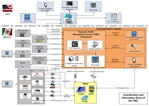
SCT is going ahead with construction of regional TMCs in the cities of Monterrey and Chihuahua. The TMCs will monitor Mexican federal roadways and toll roads, many of which terminate at international border crossings. These TMCs will be able to operate ITS field devices deployed on roadways close to border crossings and provide ATIS information that will include traffic conditions on roadways as well as border crossings (48). In addition, the ITS system envisioned by SCT includes TMCs to be operated by toll concessionaires that will share real-time data with TMCs on the U.S. side of the border (49). Figure 7 shows a sample ITS design for sharing border-crossing-related data between U.S. and Mexican agencies in the Tijuana region.
On the other hand, major cities on the U.S. side have one or more TMCs operated by the cities and/or States. City-operated TMCs mostly focus on local arterials, and the State-operated TMCs manage traffic on State-maintained highways and freeways. However, conversations with officials revealed that there has been little or no progress in sharing the TMC data with agencies in Mexico.
ITS architectures developed for border regions provide roadmaps to integrate transportation systems among agencies within the region and countries. ITS architectures typically identify stakeholder agencies and define roles and responsibilities that each agency plays in the region. In addition, the architecture identifies functions, market packages, equipment packages, and how agencies interface for specific purposes. It also includes current interfaces among agencies and ones that the region plans to implement in the future. Table 20 lists existing and planned interfaces between agencies on both sides of the border, as reflected in their corresponding regional ITS architectures. The list also demonstrates that stakeholders from individual regions have placed different priorities on interfacing with Mexican counterpart agencies.
Mexico’s National ITS Architecture was first drafted in 2005. The architecture coordinates the management and operation of various transportation facilities throughout Mexico and support personal and goods movements. The effort of development of the architecture was led by the SCT. The architecture provides a great deal of emphasis on standardization and harmonization of information exchange among Mexican and U.S. agencies at all levels.
| U.S. Border Region, State | Interface Between Agencies on Both Sides of the Border | Status |
|---|---|---|
| El Paso, Texas (69) | Includes Juarez IMIP as the only stakeholder from Mexico to exchange archived data with the El Paso MPO. | Existing |
| Laredo, Texas (69) | The Regional ITS Architecture does not include stakeholders from Mexico. | Not Applicable |
| Pharr, Texas (69) | Includes Mexican EMAs as a stakeholder group and interfaces with TMCs operated by the cities of Brownsville, Harlingen, McAllen, Pharr, and TxDOT Pharr for emergency management. | Future |
| Las Cruces, New Mexico (70) | The Regional ITS Architecture does not include stakeholders from Mexico. | Not Applicable |
| New Mexico Statewide (71) | Includes Mexican Customs and Border Patrol, which represents the border patrol agency in Chihuahua, Mexico. Interfaces with NMDOT District 1 TOC and regional EOC for traffic incident management and disaster response and recovery, respectively. | Future |
| Includes Mexico Public Safety, which represents public safety providers (police, fire, and Emergency Medical Services, or EMS) in Chihuahua, Mexico, and the surrounding Mexican States. Interfaces with New Mexico Statewide EOC and regional EOCs for disaster response and recovery. Interfaces with NM DPS Dispatch Center and NMDOT District 1 TOC for emergency call taking and dispatch and traffic incident management, respectively. |
Future | |
| Includes Mexico Regional TMC that represents the regional TMC located in Chihuahua, Mexico, that would coordinate traffic information or operations with New Mexico. Interfaces with the NMDOT District 1 TOC to regional traffic control. | Future | |
| Imperial County, California (72) | The Regional ITS Architecture does not include stakeholders from Mexico. | Not Applicable |
| Entire Mexico (49) | ITS design includes real-time information sharing between concessionaire’s TMC and State-operated ones in the U.S. along the border regions. | Future |