CASE STUDY 2: I-15 RECONSTRUCTION IN OGDEN, UTAH
Project Description
The Utah Department of Transportation (UDOT) uses a program-level traffic analysis framework called "User Impact Planning" to help facilitate implementation of construction programs and to help determine operational treatments during construction to alleviate impacts. Modeling helps UDOT better understand future operational characteristics and allows for enhanced planning activities. For example, the Statewide Transportation Improvement Program (STIP) may have multiple projects proposed for the same year. The UDOT modeling program helps decision-makers determine the timing for the construction projects at the system level and helps with scheduling decisions and letting timeframes.
The UDOT process includes three stages, where the second stage involves planning level analysis to evaluate three alternatives - no build, traditional build, and fast track design-build. The analysis at this level includes quantitative estimates of measures of effectiveness including total vehicle hours of delay per alternative. The trade off between traditional build and design build lies in the typically slow progress with moderate impacts versus fast progress with shorter, more intense impacts, respectively. In this case, the design build alternative significantly compressed the construction schedule.
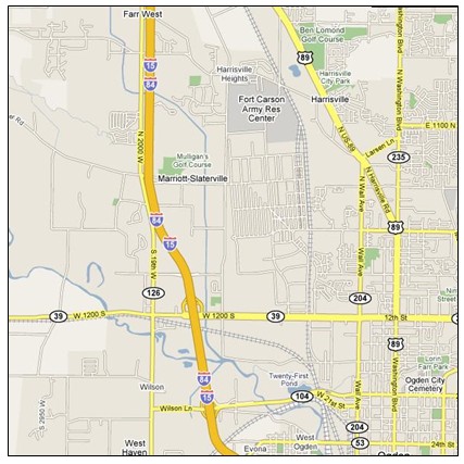
Figure 6: I-15 Corridor in Ogden, Utah
UDOT and the University of Utah performed a study in 2005 to evaluate the impact of various I-15 reconstruction closure scenarios on the travelers in the Ogden area. The purpose of the research was to investigate the impact of the scenarios during and after they were implemented on I-15 during the reconstruction period and facilitate decisions about future maintenance of traffic during other reconstruction projects. While this study was not performed prior to construction to assist with decision-making, it provided an "after" assessment of how well the model could predict the impacts from design-build decision using real-time field data. The I-15 corridor is shown in Figure 6.
For the I-15 project, the study team analyzed a paper developed by the University of Utah Traffic Lab that focused on the modeling results and associated impacts of the various I-15 reconstruction closure scenarios. The purpose of the research was to investigate the impact of the scenarios as the traffic management plans were implemented, and facilitate future decisions. Data from the Wasatch Front Regional Council (WFRC) transportation planning model were converted from a planning-level tool format to an operations-level format. However, much of the analysis relied on planning-level data. The converted model was calibrated and validated for each scenario.
UDOT places priority on reconstruction closure scenarios that efficiently use alternate routes and minimize user delay along the network. The overall UDOT user impact planning process uses traffic data from Metropolitan Planning Organizations (MPO), provides overlap throughout the entire process from planning to design to construction, and keeps decision-making processes at the regional level. UDOT uses the early analysis results to make decisions as early as possible in the overall process. Based on the modeling outcomes, UDOT applies the necessary innovative contracting techniques including incentive-disincentive, lane rental, and A+B bidding.
Analysis and Results
The design-build alternative allowed for construction to be completed faster, but the traditional build alternative would have lowered the extent of the disruption and spread it out over a longer period of time. Under traditional build, UDOT would have let up to ten separate contracts for design and construction, with construction covering a span of nearly ten years.
In consultation with UDOT project managers, the University of Utah Traffic Lab developed reconstruction closure scenarios for each alternative for the I-15 project and compared them with actual field data. Modelers executed traffic assignments for each scenario for multiple time periods, and reported measures of effectiveness for two spatial levels: area wide and corridor specific. UDOT designed the study to help quantify benefits and determine a process for selecting the best overall alternative for future projects - no build, traditional build, or design build. For the I-15 reconstruction, the no-build alternative assumes no additional capacity on I-15 through 2020. The no-build future alternative was primarily used as a baseline to determine how it compared with the benefits of the other two alternatives.
Within these alternatives, several maintenance of traffic plan components were modeled. The corridor level analysis included I-15 and several alternate routes. The main measures of effectiveness studied were vehicle hours of delay, vehicle-kilometers traveled, travel time, and average network congestion (percentage of links with a V/C ratio greater than 0.9). The model used produces metric such as average speed, travel time, and volume to capacity ratio.
UDOT experts provided some assumptions for use in the traditional build scenario, including:
- Ten year construction staging for traditional build compared with 4 ½ years for design build
- Two lanes per direction on I-15 would remain open throughout construction.
- The freeway can close completely at night only.
- Several other alternates would remain open at all times.
- When ramps are closed, ramps at consecutive interchanges would remain open.
- Construction time for a single interchange would last at least two years (three years for a major junction or pair of interchanges).
The modeling exercise included five time periods: AM peak (6-9am), PM peak (3-6pm), daytime period (9am-3pm), evening period (6-10pm), and the nighttime period (10pm-6am). The study focused on the average V/C ratios for the PM peak hour only.
Results
The model estimated savings of approximately 60 million hours of delay by using Design Build versus Traditional Build, for a fifteen year analysis period. Vehicle kilometers of travel did not differ significantly between the three alternatives; however, the model estimated that the no-build alternative would experience significant congestion and VKT would likely increase as motorists seek alternate routes that may increase their trip length. The design-build alternative proved to be the best alternative based on this "after" analysis.
Assessing the field data, it was confirmed that the analysis failed to estimate acceptably accurate V/C ratios on the corridors. Correlation coefficients were high at the average daily traffic comparison level, but when the analyst developed correlation coefficients based on data at the peak hour level they were much lower. Ultimately, however, the analysis produced data that matched fairly closely with the local MPO travel demand forecasts.
The other corridor-specific measures were found to be comparable with the field observations. The model also showed a lack of ability to reproduce accurate saturation rates for the major arterials. This inaccuracy in estimating saturation rates is inherent in the limitations of transportation planning models. The planning models must be designed to accurately distribute traffic demand over all links in the real street network. Additionally, the model included several different types of facilities including freeways, major and minor arterials, and collector roads. In addition, transportation planning models rarely include signals in their modeling procedures.
Conclusions and Recommendations
The purpose of this analysis was to highlight some of the issues experience by UDOT in assessing traffic control alternatives for a major reconstruction project. Since data were already available in analyzed format, the study team expanded on existing findings to provide insights to agencies interested in similar analysis processes. The major finding from this study lies in the potential limitation of planning tools to accurately predict future demand and volume to capacity ratios.
The University of Utah study concluded that either the arterial capacities or throughput estimates are overly reduced by the model, or the demand on the links in the model's network is overestimated. The University study also concluded that LOS values would likely be much higher than values obtained from a micro simulation or signal optimization tool, further supporting the finding that users should be careful in how they compare results, as they may not be directly comparable across different models or simulation tools. Other results from the study are more or less comparable with the field observations.
| Some planning tools account for the impacts of signalized intersections on arterials by reducing capacity on those links in the network. A micro simulation analysis tool will produce more realistic delay values compared with planning tools. In using any level of tool (planning versus simulation),the availability of high quality travel demand data is important to producing the best analysis results. |
Extensions and Guidance
The issue with V/C ratios (discussed under "Results") was due in part to limitations in the use of a transportation planning application with a desired end result being a detailed operational analysis of traffic patterns. Agencies are often faced with the challenge of predicting future traffic patterns with enough accuracy to evaluate operational-level conditions, even though the tool used may be designed mainly for the planning level. The task of determining how well traffic control alternatives will function is especially difficult, given the need to have highly accurate demand information. Additionally, a sensitivity analysis could be used to determine break points for congested conditions by providing a range of potential V/C ratios that might be expected, especially due to likely potential error in demand forecasts.
At the planning and operations levels, model networks should be large enough to include all traffic that may potentially be impacted by construction. For example, UDOT developed a network model that included major alternate routes to I-15. State agencies should also coordinate with local agencies as appropriate to ensure appropriate network coverage and to gather appropriate data to use within the model. Consequently, UDOT owns and maintains many of the alternate routes, including signalized arterials that might likely be owned by cities or counties in other states.
Since a majority of the urban population in Utah lives along the I-15 corridor and Wasatch Front, the model developed in this project will be extremely useful for future analysis without the original level of effort required to initially build the model. The overall study in this case cost $93,000, with approximately 75% of the total used in setting up the model and the remainder used in analyzing the results. During the period of performance for the original study, the Utah Traffic Lab was being constructed and therefore ultimately provided the University with direct traffic data links to the UDOT traffic management system. As with the MNDOT example, access to electronic data in near real-time was a convenient and cost-saving measure for this study.
| Special thanks to Doug Anderson, UDOT and Aleksandar Stevanovic of the University of Utah Traffic Lab for providing details and insights for use in these comparisons. |