|
||
Executive Summary1. Introduction1.1 OverviewIntelligent transportation systems (ITS) is the term used to refer to the application of information technologies to surface transportation needs. This deployment plan aims at improving the efficiency and safety of the transportation system in the Cumberland Gap Tunnel (CGT) / US 25E region. While ITS cannot solve every surface transportation problem, ITS deployment does present the opportunity to aid in addressing the region's transportation problems, and in achieving broader social needs. This Regional ITS Deployment Plan will help identify ITS applications that are most relevant to the unique nature of the Cumberland Gap Tunnel / US 25E region, and the needs of its travelers. In addition, the plan will ensure that ITS deployment is conducted in an incremental, integrated fashion, and in conformity with the National ITS architecture. The Cumberland Gap Tunnel / US 25E region presents an interesting and challenging context for developing ITS strategies because of its rather rural character, unique natural beauty, winter weather and its flourishing tourism industry. The regional ITS plan was developed around three basic principles:
The Cumberland Gap Tunnel / US 25E Regional Deployment Plan (RDP) summarizes the region’s existing transportation conditions and identifies various deficiencies and opportunities for ITS applications. It also identifies the Market Packages and Equipment Packages associated with the region’s transportation priorities. Finally, the document defines and prioritizes projects that have regional benefits. 1.2 Participating AgenciesTo facilitate activities, a planning advisory committee provided suggestions and feedback. Stakeholders included representatives from a variety of civic, traffic, and emergency response agencies serving the transportation needs of citizens in Kentucky, Tennessee and Virginia. Table 1-1 is a complete list of these participating agencies and their representatives. Additional and valuable input has also been provided by the staffs of these organizations, and by the staffs of the other public-, private-, and academic-sector organizations that have assisted with this study.
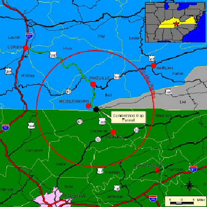
1.3 Organization of DocumentThe following sections describe the contents of this report. 1.3.1 Section 2 – Existing ITS Inventory/Capabilities/FunctionalityThis Section presents an overview of existing and planned roadway facilities in the tri-state area. Current system characteristics including traffic volumes, capacity, accident rates and congestion are discussed. Existing ITS-type functions at the tunnel are also highlighted. 1.3.2 Section 3 – User NeedsThis Section describes the process used to identify the user needs (i.e. current deficiencies and issues and future needs) throughout the CGT/US 25E region and to preliminarily consider ITS strategies to address those needs. 1.3.3 Section 4 – Regional ArchitectureThis Section contains the regional system architecture, or ITS blueprint, for the CGT/US 25E region. It presents the physical and logical aspects of the region in accordance with the National ITS Architecture. It identifies the functionality and information flows of the TMC as well as the standards to adhere to upon implementation. 1.3.4 Section 5 – Program Areas and ProjectsThis Section identifies the program areas and projects that are to be implemented for the CGT/US 25E region in the next ten years. It outlines how they were developed and organized and it provides specific information on each ITS project. This Section is a crucial part of the RDP, as it contains the background project information for use in funding applications, project promotion, and further deployment efforts. 1.3.5 Section 6 – Deployment StrategyThis Section of the RDP provides an overall view of ITS deployment in the CGT/US 25E region. Each of the ITS projects described individually in Section 5 of the RDP are reviewed collectively by program area. This collective review provides the “big picture” of ITS deployment in the region, as well as unconstrained cost estimates and timelines. 1.3.6 Section 7 – Cost of ITS DeploymentThis Section covers the cost of deployment Costs are broken down by capital and operations and maintenance associated with the project. Strategic deployment costs for short-term, medium- term, and long-term deployment is explained. Finally, the total cost of the ITS deployment is given. 1.3.7 AppendicesThere are eleven appendices that contain more detailed information on the Deployment Plan and the plan development process that was used. Appendices A – D contain traffic data for the Cumberland Gap Tunnel/US 25E region, which are the source data for the traffic data maps in Section 2. Appendices E – H contain detailed information on the National ITS Architecture Market Packages and Equipment Packages applicable to the Regional ITS architecture. Appendices I and J contain architecture flow definitions and associated standards, respectively. Appendix K contains detailed descriptions of the projects selected for the Deployment Plan and cost estimates for the projects. 2. Existing ITS Inventory/Capabilities/Functionality2.1 Area OverviewA Regional ITS project for the Cumberland Gap Tunnel/US 25E region was initiated in 1999. The area identified for application of ITS technology includes a 25-mile radius around the Cumberland Gap Tunnel plus the US 25E corridor extending approximately 100 miles from the intersection of I-75 near Corbin, Kentucky, to the intersection with I- 81 near Morristown, Tennessee. The traffic operations center for the regional system will be located in Middlesboro, Kentucky where the current Cumberland Gap Tunnel Operations Center (TOC) resides. This plan covers a twelve county area in the ITS region of the Cumberland Gap Tunnel / US 25E area. The counties include: Bell, Harlan, Knox, Laurel, Leslie and Whitley Counties in Kentucky; Campbell, Claiborne, Grainger, Hamblen and Union Counties in Tennessee; and, Lee County in Virginia. See Figure 2-1 below for study area.
|
||||||||||||||||||||||||||||||||||||||||||||||||||||||||||||||||||||||||
| US DOT Home | FHWA Home | Operations Home | Privacy Policy | ||||||||||||||||||||||||||||||||||||||||||||||||||||||||||||||||||||||||