
|
||
5.2 Concept of OperationsThe Membership Model architecture concept allows the concept of operations for OKI to be flexible. The system that will be developed for ARTIMIS enables any agency of any type to select what their membership level will be. Membership levels need not be pre-defined. The OKI Concept of Operations describes the various types of agencies that may participate in the regionally integrated ITS system, and their roles in operating the transportation network. The following sections provide both a long-term and a short-term concept of operations. The long-term concept of operations does not identify specific agencies that will participate at the various membership levels, but gives an overview of the functions performed at the various types of agencies (e.g. transit provider, emergency service, County transportation, etc.). The short-term concept of operations identifies the agencies that have indicated an interest in participating at the various membership levels. To implement the concept of operations, software and systems upgrades will be required at ARTIMIS. Tier 1 and Tier 2 members will need to be provided with an ARTIMIS workstation (personal computer) fitted with Tier 1 or Tier 2 software. In addition, a communications link will need to be established between ARTIMIS and Tier 1 and Tier 2 members. 5.2.1 Data FlowsData Flows from ARTIMIS to Tier I and Tier 2 UsersThe information flowing from ARTIMIS to any Tier 1 user will be the same for every Tier 1 user. Similarly, information flowing from ARTIMIS to any Tier 2 user will also be the same for every Tier 2 user, and will be the same data as available to each Tier 1 user. One of the differences between Tier 1 and Tier 2 users is that Tier 1 user data flow is designed to support the shared and tiered control of field devices. Data Flows from Tier I and Tier 2 Users to ARTIMISWithin the architecture and the concept of operations described below, each Tier 1 user data flow to ARTIMIS differs based on the type of agency and system (e.g, city traffic signal operations, 911 dispatch, etc.) being connected. Data flows need not be automatically sent from Tier 2 user systems to ARTIMIS. Information and data can be sent from Tier 2 users via traditional means such as phone, fax and e-mail. Tier 1 data flows to ARTIMIS are largely automated, but will be supplemented by traditional means. Table 5-2 presents Tier 1 and Tier 2 data flows and highlights their similarities and differences. The concept of operations describes these connections between systems at the various agencies. The ITS Architecture, provided in Appendix A, provides more detail regarding data flows. The architecture developed includes a full set of possible data flows to and from each Tier 1 or Tier 2 agency. These are tailored to match the possible data flows that can be extracted from the particular type of member's system. Any Tier 1 or Tier 2 member can choose to implement a smaller subset of data if this better suits their needs and circumstances.
5.2.2 Long Term Concept of OperationsThe long-term concept of operations for the Greater Cincinnati-Northern Kentucky region is graphically depicted in Figure 5-1. Data flows in Figure 5-1 do not necessarily represent the flows that will occur, but represent the entire set of possible flows that stakeholders will be able to select from in the future. Actual data flows and interfaces will be determined at some time in the future, and will be based on a three-tiered Membership Model. 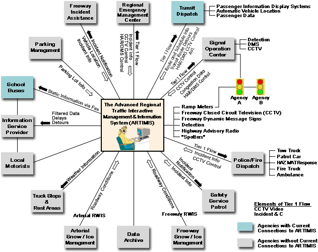
Tier 2 members will receive access to the same information that Tier 1 members will receive, but they will not be able to control field devices. Therefore, Tier 2 members are passive viewers/receivers of information collected by field devices controlled by ARTIMIS and Tier 1 users. This may be more suitable for certain agencies that want information but do not have data or systems ready for electronic connection to ARTIMIS. 5.2.2.1 Tier I /Tier 2 Agencies Roles and ResponsibilitiesThe roles and responsibilities of Tier 1 and Tier 2 agencies are described in this section. As mentioned previously, stakeholders have yet to determine which tier in which they want to belong. Emergency Management Centers - County and RegionalEmergency Management Centers (EMCs) within the OKI region are responsible for coordinating responses to major incidents, including major natural disasters, severe weather events, and man-made emergencies such as hazardous material spills and airplane crashes. In many counties in the OKI region, the County Emergency Management Center is co-located with the County 911 dispatch. Multi-county and multi-state emergency management coordination is managed by coordinating between various County-level EMCs. Regional emergency management agencies will benefit from access to non-public regional transportation information, as will be provided to Tier 1 and Tier 2 users. EMCs need to be considered for Tier 1 membership to enable access to CCTV control. EMCs will be able to confirm field and road conditions using the pan/tilt/zoom capabilities of CCTV cameras located on freeways in the region. Although HAR and DMS will be useful tools for public information dissemination during a major emergency, it is not suggested that Emergency Management Centers operate the HAR and DMS as Tier 1 users. Because emergency staff rarely use DMS and HAR, it is too difficult to expect them to remain current on the operations of these devices. Instead, ARTIMIS staff can post messages in cases of regional emergencies on behalf of the EMCs. If ARTIMIS staff are unable to remain at the ARTIMIS center due to a major emergency, a remote Tier 1 workstation will be available for ARTIMIS staff use at Emergency Management Centers. Regional Emergency Management Centers will report incident information to ARTIMIS using telephone, radio, and fax. Radio communications are the most stable during major emergencies and must be available to the Emergency Management Centers and ARTIMIS. Traffic Signal Operations Centers - City and CountyCentralized control signal systems are currently operated by no more than five cities in the greater Cincinnati region. Most signals in the region operate in an isolated mode, or in closed-loop or coordinated local/master mode on arterials. This section addresses traffic signal operations centers. Traffic incidents or special events may unexpectedly cause congestion on city arterials, which may require changes in traffic signal timing and patterns to alleviate any resulting delays. Traffic signals can be altered to give "green-time" to emergency vehicles, thus reducing en-route travel times. Such changes can be completed remotely from the operations center as congestion and event information is provided, as is accomplished today. It is envisioned that local agencies will implement traffic detection that can provide arterial congestion information to ARTIMIS, to supplement the freeway information currently available. In this way, an enhanced regional picture of system operations can be developed. In addition, arterial DMS and CCTV will be implemented and controlled from signal operations centers. These devices may be connected to ARTIMIS as Tier 1 devices, and can be operated by Tier 1 partners based on processes developed by the Tier 1 members. This will enable messages regarding incidents on freeways to be provided on arterial DMS, and vice-versa. CCTV images will be connected via ARTIMIS to all users and the public, enhancing regional congestion information. Traffic volume and occupancy data from the county and city agency devices will be collected at the Data Archive, which will be managed by ARTIMIS. Field Traffic Signal Operations - City, County, and StateA significant amount of traffic signal coordination between agencies will occur in the field between traffic signal controllers and a local master. Signals located adjacent to metered ramps will be connected to the ramp meter system, to coordinate signal operations with ramp queue conditions. Emergency vehicle signal pre-emption will also occur in the field. Signals from equipped emergency vehicles will be transmitted to intersection controllers, engaging the pre-emption sequence. If signals are connected to a central control system, the central system will collect and process the pre-emption information. Transit ManagementMETRO and TANK are the primary transit providers in southwest Ohio and northern Kentucky, respectively. Transit dispatcher centers for these two agencies are currently equipped with CAD, and their fleets with AVL, which is integrated with the CAD. As Tier 1 users, the dispatch centers CADs will be electronically connected to ARTIMIS to provide real time route and schedule information. This information will be merged with other regional information at ARTIMIS, where it will be used to create a multi-modal regional transportation network condition system. This information will be available to Tier 1 and Tier 2 users, and repackaged and disseminated to the public via the Internet, and other means managed by the Information Service Provider. Transit dispatch will use other Tier 1 users' CCTV to confirm conditions in the field. It is unlikely that transit will address HAR and DMS as Tier 1 users. Rather, any required messages will likely be infrequent, and requested for posting via telephone or radio communications. As Tier 1 users, non-public and public multi-agency information including road closures, police and fire calls affecting roads, incidents, and weather conditions will be provided to transit dispatchers so appropriate actions can be taken. Police/Fire DispatchPolice and Fire dispatch agencies with CAD can elect to be electronically connected to ARTIMIS to transmit dispatch data related to roadway incidents. The CAD data will be filtered at the dispatch site before it is sent to ARTIMIS, to ensure that only data related to roadway operations is sent. The data will include information on crashes, roadway conditions, hazardous material spills, closures for investigations and fires, and other pertinent information. The police and fire dispatch agencies that are connected electronically to ARTIMIS will be Tier 1 users, with potential access to DMS, HAR and CCTV control of other Tier 1 user devices, including ARTIMIS. Police and fire dispatch will principally use CCTV, allowing dispatchers to visually collect information on crashes and other incidents, and to provide it to field personnel. Use of HAR and DMS will not likely be included in Tier 1 police and fire dispatch capabilities. Any requests to post messages will most likely be made by phone directly to ARTIMIS or other Tier 1 agencies. CAD information will be filtered before it is sent to ARTIMIS. ARTIMIS will further filter the data before it is transmitted to the general public, to ensure that only the most pertinent information is provided and that no sensitive information is sent to the public. Police and fire dispatch centers that do not electronically connect to ARTIMIS can become Tier 2 users and have access to the full set of public and nonpublic data. Communication with Tier 2 users will primarily occur via radio and phone to exchange information on incidents that affect the roadways. ARTIMIS will also continue to monitor police scanners until the majority of regional agencies are equipped with CAD and electronically connected to ARTIMIS. Archive Data ManagementA computer server(s) will be established to automatically collect, store and manage data generated from ARTIMIS, Tier 1, and Tier 2 users. The information collected can be accessed by Tier 1 and Tier 2 users for purposes associated with transportation administration, policy evaluation, safety, planning, performance monitoring, program assessment, operations and research applications. The server will be password-protected, and agencies with access to the data will not be allowed to directly alter data in the archive. Parking Management - City of CincinnatiThere are a number of parking lots within the City of Cincinnati that are owned and operated by public and private agencies. The City of Cincinnati will gather parking lot information, including real-time availability and pricing. A computerized system will be implemented to enable real-time parking space availability information to be summarized and analyzed. Parking messages can be posted on arterial DMS, on the ARTIMIS HAR, and the Internet. A set of rules and protocols regarding when parking information will be transmitted via ARTIMIS HAR will need to be developed. The parking information will be transmitted to ARTIMIS and posted on the public Internet site. Parking availability will also be provided to all Tier 1 and Tier 2 users. A reservation system can also be included on either the City's website or the ARTIMIS site, so that drivers are guaranteed a pre-paid space before they arrive. Information Service ProvidersInformation service providers are public or private sector brokers that disseminate information collected from a third party (ARTIMIS) for dissemination to a group of subscribers. The collected third party information is customized to fit individual needs and then sent to subscribers via their personal digital assistants (PDAs), cell phones, pagers, and/or other personal communication devices. These devices can provide subscribers with information when they want it through notification made by the PDA. Subscribers can get current traffic conditions for the roadways they typically travel, transit delays for selected bus routes, and other custom information that will be useful in deciding when, where, and how their travel will occur. For example, the ISP may call a person's cell phone every day at 4:55 pm to notify him/her of the current traffic conditions along the routes he/she travels after leaving work. Information service providers are likely to be Tier 3 members. An ISP or multiple ISPs will receive filtered information, suitable for public use, from ARTIMIS pertaining to delays and other travel information. This information will be personalized and distributed to local motorists for a small fee. Subscriber statistics may be provided back to ARTIMIS, if requested and granted by the ISP. Safety Service PatrolIn the tri-state area, ARTIMIS has partnered with Samaritania to field five safety service patrol (SSP) vehicles. Samaritania contracts with CVS Stores to support the program, and CVS labels the vans with their logo, which provides CVS with advertising exposure. The focus of the SSP is on assisting motorists. The majority of their work hours are spent helping motorists restart their disabled vehicles so they may be moved off the interstate. This frees up the police resources spent identifying disabled vehicles, interviewing drivers, and calling for tows. The SSP patrol the freeway system on regular routes. As of April 1, 2001 service patrols have been operating 24 hours a day, seven days a week. When they encounter incidents, the SSP reports them to ARTIMIS via wireless communications. Freeway Incident Response TeamsThe Freeway Incident Response Team (Freeway IRT) is proposed to supplement the SSP functions. The key focus of the Freeway IRTs will be incident management. Freeway IRT vehicles are specially equipped as incident response vehicles. In addition to other equipment, they carry traffic control devices and hazardous materials kits, and can remove vehicles from roadways by either towing or pushing. The key functional roles of Freeway IRTs will be to serve as a communications focus for ARTIMIS at incident scenes. This will relieve emergency responders from this task when Freeway IRTs are present. Secondly, Freeway IRTs will be responsible for setting up and maintaining proper traffic control. This will ensure a uniform level of traffic control at incidents across the region. Again, this will be another task that Freeway IRTs take over from the emergency response staff, when Freeway IRTs are available. Freeway IRTs can be deployed by having them patrol set routes and dispatching them to incident scenes, or by placing them near key locations that are prone to incidents that cause major delays (e.g. near bridges, tunnels, and major event venues) and dispatching them to incidents as they occur. Combinations of these approaches may also be used. They will be dispatched to incident scenes by ARTIMIS via wireless communications, and maintain wireless communications throughout the duration of an incident. Snow and Ice Management - Freeway SystemIn the future, road weather information will be provided to ARTIMIS through RWIS stations located throughout the tri-state area. A combination of wireless and wire line (via the ARTIMIS fiber-optic backbone) will be used to transmit the information. The information will also be provided directly, in real time, to ODOT and KTC maintenance staff. Precipitation, roadway condition, and temperature information will help DOT maintenance crews proactively and efficiently treat roadways for snow and ice. ARTIMIS Tier 1 and Tier 2 partners will have nonpublic RWIS data sent to their ARTIMIS workstations. Filtered road condition information based on the RWIS and maintenance reports can be provided to motorists via the Internet, DMS and HAR. For major weather events, this information can be provided in advance of the region at rest areas and truck stops, via traveler information kiosks. Snow and Ice Management - County and City FacilitiesData from RWIS managed by counties and cities will also be provided to ARTIMIS, either simultaneous to delivering it to local agency maintenance and operations staff, or after the information is processed at the local agency. The connections will be either wire line or wireless, depending on location and cost. ARTIMIS (Traffic Management Center)ARTIMIS will continue to operate as the freeway traffic management center, responsible for ODOT and KTC freeway facilities. In addition, ARTIMIS will operate as the regional data hub. Data from various agencies will flow to ARTIMIS, where it will be merged with ARTIMIS data. The data will be formatted for dissemination to various users. ARTIMIS software and systems will be upgraded to support the Membership Model architecture. ARTIMIS will need to specify a standard operating system for member workstations to be installed at Tier 1 and Tier 2 agencies, so information dissemination and collection can be achieved using a common platform. ARTIMIS will gather data from and operate field devices including:
Additional information will be sent electronically from partner agencies, supplemented by telephone, fax, e-mail, traffic spotters, and monitoring police scanners. Information being sent electronically from partner agencies was described previously. Communication to and from ARTIMIS will not only occur between centers but also between devices/personnel in the field including SSPs, FIRTs, and city-owned parking management subsystems. ARTIMIS will manage a future ramp metering system, connected via the ARTIMIS fiber-optic backbone to the ARTIMIS control center. If required, the ramp meter controllers will be connected to adjacent traffic signal controllers in the field, to manage queues from ramp meters and coordinate signal timings with ramp meter timings. 5.2.3 Short Term Concept of OperationsThe short-term concept of operations calls for implementing Tier 1 and possibly Tier 2 functions for participating stakeholders. The following stakeholders have indicated, through their input during the OKI Regional ITS Plan process, that they anticipate joining ARTIMIS as Tier 1 or Tier 2 members:
|
||||||||||||||||||||||||||||||||||||||||||||||||||||||||||||||||||||||||||||||||||||||||||
| US DOT Home | FHWA Home | Operations Home | Privacy Policy | ||||||||||||||||||||||||||||||||||||||||||||||||||||||||||||||||||||||||||||||||||||||||||