4.4.3.3 Transit-Related Functional Flow Diagrams
Transit integration issues encompass a wide range of topics. The Functional
Flow Diagrams presented in this section all revolve around how transit agencies
in central Ohio can better manage their fleets and increase the efficiency
of their operations through the use of ITS. Please refer to the narratives
associated with each flow diagram for specific explanations of each element.
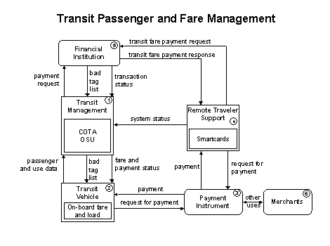
Advanced fare media, and smart cards in particular, make fare payment more
convenient for the transit user and financial management of fare revenues
more secure and efficient for the transit agency. This functional flow diagram
provides a basic representation of one way by which a transit provider will
manage fare payments with the help of ITS systems. COTA plans this type of
system as the final stage of its ITS deployment program.
 Transit
Management will manage COTA bus fleets and coordinate with other
modes of transportation. It will collect and store ridership levels and implement
corresponding fare structures. It will provide travelers with real-time travel
information, continuously updated schedules, schedule adherence information,
transfer options, transit routes and fares. It will have the capability to
accept collected data required to determine accurate ridership levels and
implement variable and flexible fare structures.
Transit
Management will manage COTA bus fleets and coordinate with other
modes of transportation. It will collect and store ridership levels and implement
corresponding fare structures. It will provide travelers with real-time travel
information, continuously updated schedules, schedule adherence information,
transfer options, transit routes and fares. It will have the capability to
accept collected data required to determine accurate ridership levels and
implement variable and flexible fare structures.
 The
Transit Vehicle will collect accurate ridership levels and
support electronic fare collection. It will provide the capability to collect
data required to determine accurate ridership levels and implement variable
and flexible fare structures. Current fare collection information, including
the operational status of the fare collection equipment and financial payment
transaction data, will be shared with the Transit Management
center. Data collected on board the transit vehicle pertaining to availability
and/or passenger count will be shared as well. Transit Management
will send lists of invalid transit passenger tags that may have previously
failed a fare payment transaction.
The
Transit Vehicle will collect accurate ridership levels and
support electronic fare collection. It will provide the capability to collect
data required to determine accurate ridership levels and implement variable
and flexible fare structures. Current fare collection information, including
the operational status of the fare collection equipment and financial payment
transaction data, will be shared with the Transit Management
center. Data collected on board the transit vehicle pertaining to availability
and/or passenger count will be shared as well. Transit Management
will send lists of invalid transit passenger tags that may have previously
failed a fare payment transaction.
 The
Payment Instrument represents the entity that enables the
actual transfer of funds from the passengers to COTA. It is proposed that
this payment instrument will be a Smart Card.
The
Payment Instrument represents the entity that enables the
actual transfer of funds from the passengers to COTA. It is proposed that
this payment instrument will be a Smart Card.
Payment Instrument facilitates requests to deduct cost of
service from passenger's payment account (payment of some kind such as a toll,
parking fee, or transit fare). Fare card maintenance, and other features that
enhance traveler convenience may also be provided at the discretion of COTA.
 Remote
Traveler Support will provide the capability to the traveler to use
a common fare medium for all applicable surface transportation services, to
pay without stopping, have payment media automatically identified as void
and/or invalid, and to have one's eligibility verified. This could be implemented
as a payment instrument reader at a kiosk. In addition, capability to provide
expansion into other uses for payment medium such as retail and telephone
and for off-line billing for fares paid by agencies will be supported.
Remote
Traveler Support will provide the capability to the traveler to use
a common fare medium for all applicable surface transportation services, to
pay without stopping, have payment media automatically identified as void
and/or invalid, and to have one's eligibility verified. This could be implemented
as a payment instrument reader at a kiosk. In addition, capability to provide
expansion into other uses for payment medium such as retail and telephone
and for off-line billing for fares paid by agencies will be supported.
 The
Financial Institution represents the organization that handles
all electronic fund transfer requests to enable the transfer of funds from
the passengers to COTA.
The
Financial Institution represents the organization that handles
all electronic fund transfer requests to enable the transfer of funds from
the passengers to COTA.
 Merchants
represent any third party entity outside the traditional ITS boundary that
could participate in using the Payment Instrument, or Smart
Card, to conduct commerce. Its functions would behave similarly to a credit
card and have no direct connection with the Transit Management
center. The only indirect connection would be that the card used to ride the
bus could also be used to make purchases at retail stores or anywhere that
would take a credit card.
Merchants
represent any third party entity outside the traditional ITS boundary that
could participate in using the Payment Instrument, or Smart
Card, to conduct commerce. Its functions would behave similarly to a credit
card and have no direct connection with the Transit Management
center. The only indirect connection would be that the card used to ride the
bus could also be used to make purchases at retail stores or anywhere that
would take a credit card.
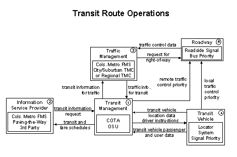
This functional flow diagram provides a basic representation of one way by
which Transit Management will manage route operations with
the help of ITS systems. It illustrates how functions such as automatic driver
assignment and monitoring, as well as vehicle routing and scheduling for fixed-route
services, could be made using ITS systems. It should be noted that all the
flows discussed here would occur similarly whether or not a regional transportation
management center, uniting transportation roles such as transit, safety, and
traffic under one roof, is built (see Regional Transportation Management
functional flow diagram). The following flows are functional flows and could
occur in a centralized or distributed scenario.
In
terms of ITS-related functions the Transit Management center
plans to manage the coach fleet by implementing a range of ITS-related systems,
the key element being instrumenting its coaches with AVL. COTA's planned use
of AVL is detailed in 4. OSU currently is using an AVL system
to manage its fleet.
Transit
Management center will provide in the future: fare structures, coach
schedules and other transit system status information to an Information
Service Provider. This share of data is in addition to providing
traveler information through its facilities (i.e., COTA kiosks, etc.). The
information discussed here is exchanged using wireline links to the Information
Service Provider where it is integrated with data from other transportation
modes such as train and air (e.g., 2-C rail, Port Columbus) to provide the
public with integrated and personalized dynamic schedules. This relationship
is further explained in the Broadcast Traveler Information, Interactive
Traveler Information and Transit Traveler Information
Functional Flow Diagrams. As noted in other flow diagrams the future nature
of the Information Service Provider is still unknown. Some elements will be
conducted by the transit authorities themselves (as COTA currently does with
its Trip Planner webpage), while others could be performed by third parties.
Coordination
between Transit Management and Traffic Management
(the Columbus Metropolitan Freeway Management System and other suburban TMCs)
is a critical step toward achieving the maximum benefit of ITS systems. COTA's
coaches with AVL instruments will act as probes on the city street system,
providing an additional level of traffic surveillance to the region's freeway
management system. Likewise, providing COTA communications personnel with
highway surveillance information provided by the Columbus Metropolitan Freeway
Management System enhances their ability to manage the system efficiently.
The Traffic Management center also provides the capability
of signal control to allow signal priority for COTA buses. Current transit
system operations information indicating current transit routes, the level
of service on each route, and the progress of individual vehicles along their
routes will be obtained from the Transit Management center.
The Traffic Management center will receive requests for signal
priority at one or more intersections along a particular route. It could also
send back the status of signal priority request functions at the roadside
(e.g., enabled or disabled).
COTA's
Transit Vehicles will be equipped with AVL devices to enhance
the efficiencies of operations. AVL systems use on-board computers and positioning
systems like GPS to monitor vehicle locations. Because of its ability to provide
exact vehicle locations in real-time, the AVL system is considered the backbone
for the implementation of most other transit ITS systems. One important aspect
of obtaining exact vehicle locations in real-time is the ability to use this
information to monitor the vehicle's schedule adherence in real-time. The
drivers are constantly aware if they are running late, early, or on time;
thus, they can instantly adjust their speeds to maintain schedule adherence.
By maintaining schedule adherence, coaches are then able to reach their stops
on time and allow timely transfers. This will translate into a convenient,
efficient and reliable transit system. Transit coaches equipped with AVL could
also serve as traffic probes, as their location and speed information is instantaneously
shared with traffic engineers, as described in 3. The benefits
of an AVL system could be summarized as follows:
- Increased overall dispatching and operating efficiency
- More reliable services
- Quick response to service disruptions
The Transit Vehicle will also provide the capability for
COTA buses to request signal priority directly with traffic control equipment
at the roadside.
The
Roadway will be provided the capability to receive vehicle
signal priority requests and control roadside signals accordingly.
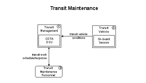
The Transit Maintenance functional flow diagram shows how
future automatic maintenance scheduling and monitoring could be performed.
On-board condition sensors will monitor critical system status (e.g., mileage,
engine temperature, fluid levels) and transmit critical status information
to the Transit Management center. Hardware and software in
the Transit Management center will process these data and
schedule appropriate maintenance activities with their maintenance sections.
Currently, neither COTA nor OSU has added this capability; however, the city
of Columbus Division of Police is testing a demonstration of this type of
system on a sample of its cruiser fleet.
Transit
Management will provide advanced maintenance functions for transit
property to include coaches, trucks and cars. It will collect operational
and maintenance data from COTA and OSU buses, manage vehicle service histories
and monitor drivers and buses. It will collect vehicle mileage data and use
it to automatically generate preventative maintenance schedules for each vehicle
by utilizing vehicle-tracking data from a prerequisite vehicle tracking equipment
package. In addition, it will provide information to proper service personnel
to support maintenance activities. It will record and verify that maintenance
work was performed.
Operating
conditions of transit vehicles (e.g., mileage, engine, temp, fluid levels)
will be sent to the Transit Management center. The Transit
Vehicle will provide the capability to use mileage data to automatically
generate preventative maintenance schedules for each specific coach, truck
or car by utilizing vehicle tracking data and storing it using a trip computer.
It will also provide the capability for real-time condition monitoring on
board the vehicle, and transmission of this information via two-way communication
to the Transit Management center.
Transit
Maintenance Personnel represent the staff that will be responsible
for monitoring, controlling and planning the schedules for the maintenance
of transit fleets. Transit Management will send confirmation
of a request for transit information or service to the Transit Maintenance
Personnel.
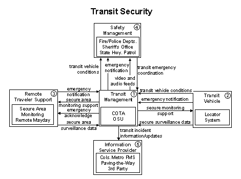
This functional flow diagram represents how the security system components
are related. This system will perform surveillance and warn of potentially
hazardous situations. Information will be communicated to the Transit
Management center using the existing or emerging wireless (vehicle
to center) or wireline (area to center) infrastructure.
The
Transit Management center will monitor key transit locations,
for COTA as well as for OSU, with both video and audio systems automatically
alerting operators and police of potential incidents and supporting traveler-activated
alarms.
The
Transit Vehicle will be monitored for safety using on-board
safety sensors, processors and communications. The Transit Management
center will be notified about emergency situations originated by a traveler
using an in-vehicle, public access or personal device. Sufficient information
is provided so that the recipient can determine the location of the emergency
at a minimum. The Transit Management center will acknowledge
requests for emergency assistance and provide additional details regarding
actions and verification requirements.
Currently, COTA buses have video surveillance cameras inside them for passenger
safety and cameras facing the outside front of the bus for vandalism purposes.
COTA has also recently upgraded its radio system to allow for monitoring
during emergency situations. The bus driver is able to notify the radio communications
center of an incident on the bus without notifying the assailant that help
is on the way.
Remote
Traveler Support in this diagram represents the capability to monitor
the safety of transit passengers at remote locations (shelters, transit centers,
etc). It will collect surveillance images and data and relay this information
back to the Transit Management center. A remote mayday system,
such as an emergency call box, will provide the capability to report an emergency
and summon assistance. It will include a traveler interface that facilitates
generation of a distress signal and carries it and allows follow-up verification
and determination of the nature of the emergency and the required response.
Originated by a traveler using an in-vehicle, public access device, Remote
Traveler Support will notify the Transit Management
center regarding emergency and request for assistance. Transit Management
then acknowledges this request for emergency assistance and provides additional
details regarding actions and verification requirements. Transit Management
will control surveillance equipment and security sensors that monitor public
transportation areas. The data collected from surveillance systems used to
monitor secure areas include video, audio, and other security sensor outputs.
Safety
Management will create, store and utilize emergency response plans
to facilitate coordinated response. Safety Management will
be notified by the Transit Management center about transit
emergencies at a transit stop, transit shelters, transit centers or on transit
vehicles. Data will be exchanged between the two centers to deal with a transit-related
incident. Further coordination takes place, as additional details become available.
The
Information Service Provider will collect, process, store
and disseminate transportation information to system operators and to the
traveling public. It can play several different roles in an integrated ITS
system. The Transit Management center will send information
to the Information Service Provider on transit incidents
that impact transit services for public dissemination.
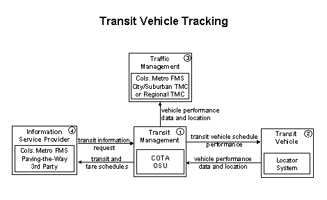
This functional flow diagram provides a basic representation on how transit
operations can be improved with the use of AVL using on-board computers and
positioning systems such as GPS to monitor vehicle locations. Because of its
ability to provide exact vehicle locations in real-time, the AVL system is
considered the backbone for the implementation of most other transit ITS systems.
One important aspect of obtaining exact vehicle locations in real-time is
the ability to use this information to monitor the vehicle schedule adherence
in real-time. This will translate into a convenient, efficient and reliable
bus service.
Enhanced operating efficiency and service should translate into increased
ridership and therefore less congestion. For example, in Baltimore, Maryland
buses equipped with automatic vehicle identification have a 23 percent better
record of on-time performance. In central Ohio, of the two transit systems
deploying ITS, COTA and OSU, only OSU has a system that is currently operating.
The OSU BLIS System was a demonstration project that is currently being upgraded
to fulfill a more long-term mission. COTA plans to implement an AVL system
as part of its six-year ITS plan.
Transit
Management facilities will provide the capabilities for monitoring
Transit Vehicle locations and determining vehicle schedule
adherence. In central Ohio the two transit systems deploying ITS include COTA
and OSU. These ITS systems will allow the Transit Management
center to use this tracking information to furnish passengers with real-time
travel-related information. This information is continuously updated with
real-time information from each transit system and provides passengers with
the latest available information on transit routes in addition to schedules,
transfer options, fares, real-time schedule adherence, current incident conditions,
weather conditions and special events. The systems will also support the capability
for two-way voice and data communication with the Transit Vehicle
driver.
The
Transit Vehicle will provide the capabilities to support
fleet management with automatic vehicle location and automated mileage and
fuel reporting and auditing. AVL systems can also record other special events
resulting from communication with roadside equipment. This includes only the
equipment on board the vehicle to support this function including the vehicle
location devices such as GPS equipment, communication interfaces, a processor
to record trip length, and the sensors, actuators, and interfaces necessary
to record mileage and fuel usage. COTA plans to use a GPS-based system to
accomplish these processes.
The Transit Vehicle will provide current transit vehicle
location and related operational conditions data (e.g., speed, vehicle number,
driver number, route ID). The Transit Management center will
send back the current and projected transit schedule adherence for the driver's
information.
Coordination
between Transit Management and Traffic Management
(the Columbus Metropolitan Freeway Management System and other suburban TMCs)
is a critical step toward achieving the maximum benefit of ITS systems.
COTA's and OSU's coaches with AVL instruments will act as probes on the city
street system, providing an additional level of traffic surveillance to the
region's freeway management system. Likewise, providing COTA and OSU communications
personnel with highway surveillance information provided by the freeway management
system enhances their ability to manage the system efficiently.
As
discussed in 1, Transit Management will
update the transit schedule and make real-time schedule and fare schedule
information available to the Information Service Provider
(which collects, processes, stores and disseminates transportation information
to system operators and the traveling public). This share of data is in addition
to providing traveler information through their facilities (i.e., COTA and
OSU traveler information displays at shelters, WebPages, kiosks, etc.).
The information discussed here is exchanged using wireline links to the Information
Service Provider where it is integrated with data from other transportation
modes such as train and air (e.g., 2-C rail, Port Columbus) to provide the
public with integrated and personalized dynamic schedules. This relationship
is further explained in the Broadcast Traveler Information, Interactive
Traveler Information and Transit Traveler Information
Functional Flow Diagrams.
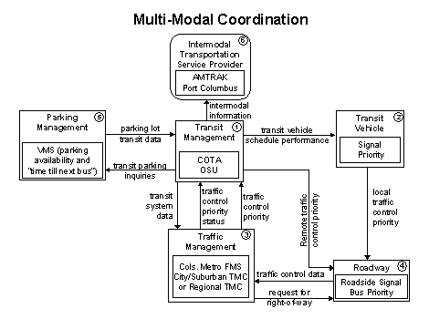
This functional flow diagram illustrates how two-way communications between
various agencies can improve service coordination across modes. Intermodal
coordination between transit agencies can increase traveler convenience at
transfer points and also improve operating efficiency. Coordination between
traffic and transit management is intended to improve on-time performance
of the transit system to the extent that this can be accommodated without
degrading overall performance of the traffic network. Currently, neither transit
agency in central Ohio coordinates at the level described here, but it is
desired that they pursue such integration.
The
Transit Management facility will determine the need for transit
priority on routes and at certain intersections and request transit vehicle
priority at these locations. It will also support schedule coordination between
transit properties and coordinate with other surface and air transportation
modes.
The
Transit Vehicle will provide the capability for COTA buses
to request signal priority through short-range communication directly with
traffic control equipment at the roadside.
The
Traffic Management center provides the capability of signal
control to allow signal priority for COTA buses. Current transit system operations
information indicating current transit routes, the level of service on each
route, and the progress of individual vehicles along their routes will be
obtained from the Transit Management center. The Traffic
Management center will receive requests for signal priority at one
or more intersections along a particular route. It could also send back the
status of signal priority request functions at the roadside (e.g., enabled
or disabled).
The
Roadway will be provided the capability to receive vehicle
signal priority requests and control roadside signals accordingly.
Parking
Management will provide the capability to provide parking availability
and parking fee information, and allow for parking payment without the use
of cash with a multiple- use medium at COTA and OSU facilities. It will also
support the detection, classification, and control of vehicles seeking parking.
The Transit Management center will respond to transit occupancy
inquiries and coordinate with Parking Management.
Schedule information for alternate mode transportation providers such as train
(2-C rail), air (Port Columbus), and bus, will be exchanged between the Transit
Management center and Intermodal Transportation Service Providers.
This two-way interface will enable coordination for efficient movement of
people and goods across multiple transportation modes. It also enables the
traveler to efficiently plan itineraries that include segments using various
modes of travel.
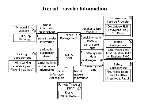
This functional flow diagram provides transit users at transit stops and
aboard transit vehicles with ready access to transit information. The information
services include transit stop annunciation, arrival signs and real-time transit
schedule displays that are of general interest to transit users. Systems that
provide custom transit trip itineraries and other tailored transit information
services are also represented in this diagram. Currently, COTA plans to implement
a variety of traveler information devices. OSU currently offers real-time
location of its buses on its WebPage and "time till next bus" info
at some shelters on its campus.
The goal for future transit information, regardless if it's COTA or OSU information,
is to make it available to users at one location and to ensure that it is
"seamless" to the eyes of the traveler.
Transit
Management manages transit vehicle fleets and coordinates with other
modes and transportation services. Transit Management receives
special event and real-time incident data from Traffic Management
and Safety Management and provides current transit operations
data back to these centers. Transit Management collects and
stores accurate ridership levels and implements corresponding fare structures.
A potential use for this type of system would be COTA through its webpage.
Transit
Management also provides the capability for automated planning and
scheduling of public transit operations. It furnishes travelers with real-time
travel information, continuously updated schedules, schedule adherence information,
transfer options, and transit routes and fares through an Information
Service Provider (see 4) and Personal Information
Access.
Parking
Management provides the capability to provide parking availability
and parking fee information, to allow for parking payment without the use
of cash with a multiple-use medium, and to support the detection, classification,
and control of vehicles seeking parking.
Parking Management has a connection to Transit Management
for the purpose of traveler information. Park and Ride facilities will have
VMS on major arterials and freeways prior to entrance onto them. VMS will
show parking availability and approximate travel time to downtown to encourage
use of these services. COTA plans to implement this at various transit centers
and park and rides in its system.
The
Information Service Provider collects, processes, stores,
and disseminates transportation information to system operators and the traveling
public. The role of the Information Service Provider is focused
on delivery of traveler information to subscribers and the public at large.
Information provided includes basic advisories, real-time traffic condition
and transit schedule information, yellow pages information, ridematching information,
and parking information. The Information Service Provider
also provides the capability to provide specific directions to travelers by
receiving origin and destination requests from travelers, generating route
plans and returning the calculated plans to the users. Although OSU has no
current plans to implement this level of service, COTA does plan to provide
this service.
In addition to general route planning for travelers, the Information
Service Provider also supports specialized route planning for vehicle
fleets. In this role, the Information Service Provider function
may be dedicated to, or even embedded within, the dispatch system. Reservation
services are also provided in advanced implementations. The information is
provided to the traveler through Personal Information Access, Remote
Traveler Support and various other systems through available communications
links.
It is uncertain how the Information Service Provider's role will be divided
in terms of providing transit traveler information. Some degree will be provided,
as is done currently, by the transit systems themselves; other elements could
be provided by entities such as Paving the Way or a third party altogether.
Traffic
Management communicates with the roadway to monitor and manage traffic
flow. Incidents are detected and verified and incident information is provided
to Safety Management, travelers (through HAR and VMS), and to third party
Information Service Providers. Traffic Management communicates
with other traffic management centers to coordinate traffic information and
control strategies in neighboring jurisdictions.
Safety
Management operates in various emergency centers supporting public
safety including police and fire stations, search and rescue special detachments,
and HAZMAT response teams. Real-time traffic information received from Transit
Management is used to aid the emergency dispatcher in selecting the
emergency vehicle(s) and routes that will provide the most timely response.
Interface with the Transit Management center also allows
coordinated use of transit vehicles to facilitate response to major emergencies.
COTA currently has this arrangement with various Safety Management
Centers such as the Franklin County EMA.
 Remote
Traveler Support provides access to traveler information at transit
stations, transit stops, other fixed sites along travel routes, and at major
trip generation locations such as special event centers (Greater Columbus
Convention Center, Port Columbus, etc.), hotels, office complexes, amusement
parks and theatres. At transit stops, simple displays providing schedule information
and imminent arrival signals can be provided. This basic information may be
extended to include multimodal information including traffic conditions and
transit schedules along with yellow pages information to support mode and
route selection at major trip generation sites. Personalized route planning
and route guidance information can also be provided based on criteria supplied
by the traveler. As mentioned in other flow diagrams, the Columbus Metropolitan
Freeway Management Center has a desire to integrate the Remote Traveler
Support whenever possible.
Remote
Traveler Support provides access to traveler information at transit
stations, transit stops, other fixed sites along travel routes, and at major
trip generation locations such as special event centers (Greater Columbus
Convention Center, Port Columbus, etc.), hotels, office complexes, amusement
parks and theatres. At transit stops, simple displays providing schedule information
and imminent arrival signals can be provided. This basic information may be
extended to include multimodal information including traffic conditions and
transit schedules along with yellow pages information to support mode and
route selection at major trip generation sites. Personalized route planning
and route guidance information can also be provided based on criteria supplied
by the traveler. As mentioned in other flow diagrams, the Columbus Metropolitan
Freeway Management Center has a desire to integrate the Remote Traveler
Support whenever possible.
previous page | next page
