4.4.3.1 Traveler Information-Related Functional Flow Diagrams
Traveler Information, one of the key components of any ITS regional deployment,
depends on the coordination of multiple entities. The Functional Flow Diagrams
presented in this section all revolve around how Traveler Information is and
could be provided. Please refer to the narratives associated with each flow
diagram for specific explanations of each element.
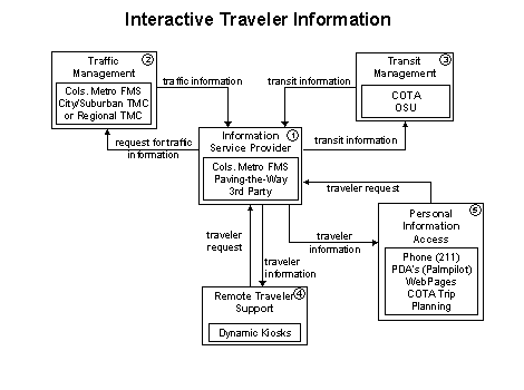
This functional flow diagram provides a basic representation of one way by
which Information Service Providers could provide traveler
information to the public in central Ohio. Interactive Traveler Information
refers to providing tailored information in response to a traveler request.
Both real-time interactive request/response systems and information systems
that "push" a tailored stream of information to the traveler based
on a submitted profile will be supported. The traveler will obtain current
information regarding traffic conditions, transit services, traveler services,
ride share/ride match, parking management, and pricing information. A range
of two-way, wide-area wireless and wireline communications systems will be
used to support the required digital communications between traveler and the
Information Service Provider. A variety of interactive devices
may be used by the traveler to access information prior to a trip or en route
to include phone, kiosks, Personal Digital Assistants and the Web.
 It is still uncertain whether the Information Service Provider
functions will be performed exclusively by the Columbus Metropolitan Freeway
Management System, or shared by another party altogether, such as the Paving
the Way Program, or a third party such as SmarTraveler. It is known that the
Columbus Metropolitan Freeway Management System will provide a traveler information
web page. This page will provide freeway system status and stillstore video
images from their cameras on the freeway system. Potential additional information
will include ride share/ride match, construction information, incident information,
and special event updates.
It is still uncertain whether the Information Service Provider
functions will be performed exclusively by the Columbus Metropolitan Freeway
Management System, or shared by another party altogether, such as the Paving
the Way Program, or a third party such as SmarTraveler. It is known that the
Columbus Metropolitan Freeway Management System will provide a traveler information
web page. This page will provide freeway system status and stillstore video
images from their cameras on the freeway system. Potential additional information
will include ride share/ride match, construction information, incident information,
and special event updates.
 As
noted in 1, the Columbus Metropolitan Freeway Management
System may itself conduct much of the functionality outlined here in this
diagram. However, to illustrate the types of information flowing "functionally,"
it has been broken into two elements. Whatever form the Information
Service Provider finally takes, the Columbus Metropolitan Freeway
Management Center will provide freeway system status information to include:
video feed from the center's cameras, speeds on links, and text that the VMS
are displaying. It is anticipated that beyond the web page, the Columbus Metropolitan
Freeway Management System will provide "raw data" to other interested
parties wishing to provide traveler information. However, that information
would have to be formatted by those other parties for distribution to the
public.
As
noted in 1, the Columbus Metropolitan Freeway Management
System may itself conduct much of the functionality outlined here in this
diagram. However, to illustrate the types of information flowing "functionally,"
it has been broken into two elements. Whatever form the Information
Service Provider finally takes, the Columbus Metropolitan Freeway
Management Center will provide freeway system status information to include:
video feed from the center's cameras, speeds on links, and text that the VMS
are displaying. It is anticipated that beyond the web page, the Columbus Metropolitan
Freeway Management System will provide "raw data" to other interested
parties wishing to provide traveler information. However, that information
would have to be formatted by those other parties for distribution to the
public.
 COTA's
Transit Management facility plans to provide information
on fare structures, coach schedules and other transit system status information
to other venues beyond providing traveler information through their facilities
(shelters and transit centers). Therefore, they are included as an integral
part of this relationship. Projects that COTA has planned for traveler information
include: real-time transit information on the web, transit center and park
and ride information displays and park and ride lot VMS. OSU currently offers
real-time location of its buses on its web page and "time till next bus"
information at some shelters on their campus.
COTA's
Transit Management facility plans to provide information
on fare structures, coach schedules and other transit system status information
to other venues beyond providing traveler information through their facilities
(shelters and transit centers). Therefore, they are included as an integral
part of this relationship. Projects that COTA has planned for traveler information
include: real-time transit information on the web, transit center and park
and ride information displays and park and ride lot VMS. OSU currently offers
real-time location of its buses on its web page and "time till next bus"
information at some shelters on their campus.
 Remote
Traveler Support systems refer to fixed devices located in public
places which provide the public with traveler information (i.e., kiosks, marquees,
etc.). The Columbus Metropolitan Freeway Management System will provide kiosks
in public areas such as the arena, Convention Center and major shopping centers.
COTA and the region's Freeway Management System are pursuing the ability to
combine their kiosks or at least collocate them to provide travelers with
multimodal traveler information. Unlike kiosks described in the Broadcast
Traveler Information flow diagram, these kiosks provide the traveler the capability
to interact with the kiosk and query the system for information (i.e., COTA
schedules, time till next bus, freeway conditions, etc).
Remote
Traveler Support systems refer to fixed devices located in public
places which provide the public with traveler information (i.e., kiosks, marquees,
etc.). The Columbus Metropolitan Freeway Management System will provide kiosks
in public areas such as the arena, Convention Center and major shopping centers.
COTA and the region's Freeway Management System are pursuing the ability to
combine their kiosks or at least collocate them to provide travelers with
multimodal traveler information. Unlike kiosks described in the Broadcast
Traveler Information flow diagram, these kiosks provide the traveler the capability
to interact with the kiosk and query the system for information (i.e., COTA
schedules, time till next bus, freeway conditions, etc).
 Personal
Information Access systems refer to devices that are either owned
or controlled by an individual traveler but do not allow any input or feedback
from the traveler. These systems include Web pages, 211 and Personal Data
Assistants (PDAs). There is a desire on behalf of all stakeholders that the
information provided to travelers includes as many sources as possible (i.e.,
traffic, transit, incidents, rideshare and construction). As mentioned in
2, the largest hurdle in achieving this goal is in formatting
and maintaining the information gathered from the wide variety of sources
for to the public.
Personal
Information Access systems refer to devices that are either owned
or controlled by an individual traveler but do not allow any input or feedback
from the traveler. These systems include Web pages, 211 and Personal Data
Assistants (PDAs). There is a desire on behalf of all stakeholders that the
information provided to travelers includes as many sources as possible (i.e.,
traffic, transit, incidents, rideshare and construction). As mentioned in
2, the largest hurdle in achieving this goal is in formatting
and maintaining the information gathered from the wide variety of sources
for to the public.
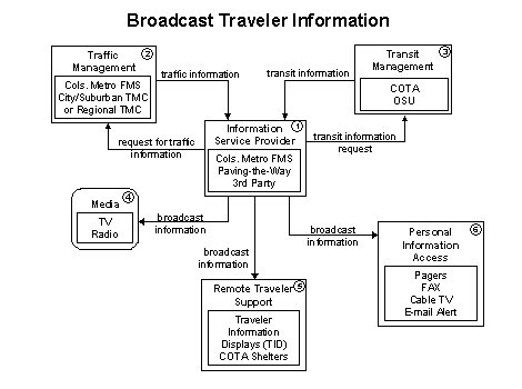
This functional flow diagram provides a basic representation of one way by
which Information Service Providers could provide traveler
information to the public in central Ohio. Broadcast Traveler Information
refers to delivering information in a non-interactive manner through existing
communication infrastructure and low cost user equipment (e.g., FM, fax, cable
TV). Travelers could access this information but could not query the system
for any additional information or interact with it in any way.
It is still uncertain whether the Information Service Provider
functions will be performed by the Columbus Metropolitan Freeway Management
System or another party altogether, such as the Paving the Way Program, or
a third party. It is known that the Columbus Metropolitan Freeway Management
System will provide a traveler information web page. This page will provide
freeway system status and stillstore video images from its cameras on the
freeway system. This capability is discussed in detail in the Interactive
Traveler Information flow diagram.
As noted in 1, the Columbus Metropolitan Freeway Management
System may itself conduct much of the functionality outlined here in this
diagram. However, to illustrate the types of information flowing "functionally,"
it has been broken into two elements. Whatever form the Information Service
Provider finally takes, the Columbus Metropolitan Freeway Management Center
will provide freeway system status information to include: video feed from
the center's cameras, speeds on links and text that the VMS are displaying.
It is anticipated that beyond the web page, the Columbus Metropolitan Freeway
Management System will provide "raw data" to other interested parties
wishing to provide traveler information. However, that information would have
to be formatted by those other parties for distribution to the public.
COTA's Transit Management facility plans to provide information
on fare structures, coach schedules and other transit system status information
to other venues beyond providing traveler information through its facilities
(shelters and transit centers). Therefore, they are included as an integral
part of this relationship.
The Media already have a close working relationship with
the city of Columbus' Traffic Management Center (TMC), and it is anticipated
this relationship will continue when the Columbus Metropolitan Freeway Management
System comes on line. Radio Traffic Broadcasters are currently located in
the city of Columbus' TMC and will continue being located inside the facility
when the Columbus Metropolitan Freeway Management Center comes on line. Local
TV news organizations currently receive video images from the city's Traffic
Management Center. They will continue to receive images from the additional
cameras that are part of the Columbus Metropolitan Freeway Management System.
Remote
Traveler Support systems refer to fixed devices located in public
places which provide the public with traveler information (i.e., kiosks, marquees,
etc.). The Region's Freeway Management System will provide kiosks in public
areas such as the arena, Convention Center and major shopping centers. COTA
and the Region's Freeway Management System are pursuing the ability to combine
their kiosks or at least collocate them to provide travelers with multimodal
traveler information.
 Personal
Information Access systems refer to devices that are either owned
or controlled by an individual traveler but do not allow any input or feedback
from the traveler. These systems include faxes, pagers, cable TV and e-mail.
The region would like to see the development of all such systems. The use
of a cable TV traffic channel which would operate during rush hour is currently
scheduled to be part of the Columbus Metropolitan Freeway Management System
and will broadcast freeway information (flow map, CCTV images and incident
information). Such a channel would provide a rotating video feed from the
Columbus Metropolitan Freeway Management System, a map illustrating speeds
on specific roadways through color-coding and information on construction
that could affect commuters. Additional information could include special
event news as it pertains to the interstate and roadways. It should be noted
that there is a desire on behalf of all stakeholders that the information
provided to travelers includes as many sources as possible (i.e., traffic,
transit, incidents and construction). As mentioned in 2,
the largest hurdle in achieving this goal is formatting and maintaining the
information gathered from the wide variety of sources for distribution to
the public. E-mail, fax and pager traffic alert systems are also of interest
to the region. Such systems will work by allowing travelers to receive specific
route information on a scheduled basis. (i.e., at 5:20 p.m. Monday through
Friday traffic information will be sent to the traveler's fax machine, pager
or e-mail address. In the case of e-mail, in addition to a text traffic update
message, a stillstore video image of the interested route will be sent along
with a map showing any incidents and speeds on the route.
Personal
Information Access systems refer to devices that are either owned
or controlled by an individual traveler but do not allow any input or feedback
from the traveler. These systems include faxes, pagers, cable TV and e-mail.
The region would like to see the development of all such systems. The use
of a cable TV traffic channel which would operate during rush hour is currently
scheduled to be part of the Columbus Metropolitan Freeway Management System
and will broadcast freeway information (flow map, CCTV images and incident
information). Such a channel would provide a rotating video feed from the
Columbus Metropolitan Freeway Management System, a map illustrating speeds
on specific roadways through color-coding and information on construction
that could affect commuters. Additional information could include special
event news as it pertains to the interstate and roadways. It should be noted
that there is a desire on behalf of all stakeholders that the information
provided to travelers includes as many sources as possible (i.e., traffic,
transit, incidents and construction). As mentioned in 2,
the largest hurdle in achieving this goal is formatting and maintaining the
information gathered from the wide variety of sources for distribution to
the public. E-mail, fax and pager traffic alert systems are also of interest
to the region. Such systems will work by allowing travelers to receive specific
route information on a scheduled basis. (i.e., at 5:20 p.m. Monday through
Friday traffic information will be sent to the traveler's fax machine, pager
or e-mail address. In the case of e-mail, in addition to a text traffic update
message, a stillstore video image of the interested route will be sent along
with a map showing any incidents and speeds on the route.
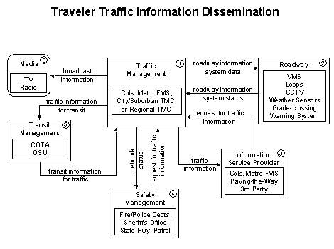
This functional flow diagram allows traffic information to be disseminated
to drivers and vehicles using roadway equipment such as VMS or highway advisory
radio. Traveler Traffic Information Dissemination provides
a tool that can be used to notify drivers of incidents; careful placement
of the roadway equipment provides the information at points in the network
where the drivers can tailor their routes to account for the new information.
This diagram also provides a link for traffic information from a TMC to the
media (for instance via a direct tie-in between a TMC and radio or television
station computer system), transit management center, safety management center
and information service provider.
Traffic
Management communicates with the Roadway to monitor
and manage traffic flow. Incidents are detected and verified and incident
information is provided to Safety Management. Other pertinent
information is disseminated and transmitted to Transit Management,
Information Service Providers and to the Media.
All of these entities also collect information to be fed back into Traffic
Management to be disseminated and passed along to other agencies
requiring the information.
The Roadway contains equipment that monitors and controls
traffic. This equipment includes highway advisory radios, VMS, cellular call
boxes, CCTV cameras, vehicle detectors, traffic signals, railroad grade crossing
warning systems and freeway ramp metering systems. The Roadway
also provides the capability for environmental condition monitoring including
weather sensors, pavement icing sensors, fog, etc.
The information that is obtained by the equipment in the Roadway
is sent to the Traffic Management center for dissemination
and formatting. After this is done, the Roadway information
is then transmitted back to the roadway via VMS, altered signal timing plans,
railroad grade status, etc.
The Information Service Provider collects, processes, stores,
and disseminates transportation information to system operators and to the
traveling public. The Information Service Provider is focused
on delivery of traveler information to subscribers and the public at large.
Information provided includes basic advisories, real-time traffic condition
and transit schedule information, yellow pages information, ridematching information
and parking information that comes disseminated from the Traffic Management
center.
The Columbus Metropolitan Freeway Management System may itself conduct much
of the functionality outlined here in this diagram. However, to illustrate
the types of information flowing "functionally," it has been broken
into two elements. Whatever form the Information Service Provider finally
takes, the Columbus Metropolitan Freeway Management Center will provide freeway
system status information to include: video feed from the center's cameras,
speeds on links, and text that the VMS are displaying. It is anticipated that
beyond the web page, the Columbus Metropolitan Freeway Management System will
provide "raw data" to other interested parties wishing to provide
traveler information. However, that information would have to be formatted
by those other parties for distribution to the public.
COTA's Transit Management facility plans to provide information
on fare structures, coach schedules and other transit system status information
to other venues beyond providing traveler information through its facilities
(shelters and transit centers). Therefore, they are included as an integral
part of this relationship.
Using the Traffic Management center information, the Information
Service Provider could also provide specific directions to travelers
by receiving origin and destination requests from travelers, generating route
plans, and returning the calculated plans to the users. This is a long-term
goal in central Ohio
Safety
Management operates in various emergency centers supporting public
safety including police and fire stations, search and rescue special detachments,
and HAZMAT response teams. Safety Management creates, stores
and utilizes emergency response plans to facilitate coordinated response.
The fist step toward this integration is the city of Columbus police and fire
dispatchers receiving the Columbus Metropolitan Freeway Management System
feed for improved freeway and major arterial incident response.
Disseminated real-time traffic information is used to aide the emergency
dispatcher in selecting the emergency vehicle(s) and routes that will provide
the most timely response. Interfacing with Traffic Management
allows strategic coordination in tailoring traffic control to support en-route
emergency vehicles.
Transit
Management receives special event and real-time incident data from
the Traffic Management center. Transit Management
uses this information to furnish transit travelers with real-time travel information,
continuously updated schedules, schedule adherence information, transfer options,
and transit routes and fares. COTA transfers information to travelers via
its web site, traveler information displays in transit shelters and via park
and ride VMS. OSU currently offers real-time location of its buses on its
web page and "time till next bus" information at some shelters on
its campus.
COTA also provides information to the Traffic Management
center on road speeds and travel times from transit vehicles equipped with
AVL, acting like probes in traffic along arterial streets.
Media
represent the information systems that provide traffic reports, travel conditions,
and other transportation-related news services to the traveling public through
radio, TV, and other media. Disseminated traffic and travel advisory information
that is collected is provided here. It is also a source for traffic flow information,
incident and special event information and other events that may have implications
for the transportation system.
The Media already have a close working relationship with
the city of Columbus' TMC and it is anticipated this relationship will continue
when the Columbus Metropolitan Freeway Management System comes on line. Radio
Traffic Broadcasters are currently located in the city of Columbus' TMC and
will continue being located inside the facility when the Columbus Metropolitan
Freeway Management Center comes on line. Local TV news organizations currently
receive video images from the city's Traffic Management Center. They will
continue to receive images from the additional cameras that are part of the
Columbus Metropolitan Freeway Management System.
previous page | next page
