Results
Crossing Volumes
Figures A1 and A2 show crossing volumes by hour for inbound and outbound crossings respectively. Figures A3 through A6 show inbound and outbound volumes for southern and northern ports of entry respectively. Most notable in the figures are the differences in relative volumes between northern border crossings and southern border crossings. Southern crossings generally handle more traffic with generally more variability. Northern border crossing volumes, except for the Ambassador Bridge tend to be more consistent throughout the measurement periods. The significance of these differences as they relate to travel/delay times and other issues is discussed elsewhere in this report.
Delay Time
Average delay times were calculated for each port of entry (see Table 2 and Figure 3). The delay time represents the difference between the average crossing time and the free-flow crossing time. Inbound delay times exceed outbound delay times and southern border delay times exceed northern border delay times. In total, for all ports of entry, the average inbound delay time is 16.0 minutes and the average outbound delay time is 8.1 minutes. The average delay time for all ports of entry, both inbound and outbound, is 12.4 minutes.
| Delay Time and Location | Time in Minutes |
|---|---|
| Ambassador Bridge Inbound Delay | 7.5 |
| Ambassador Bridge Outbound Delay | 3.1 |
| Blaine Inbound Delay | 9.2 |
| Blaine Outbound Delay | 16.2 |
| Blue Water Bridge Inbound Delay | 23.1 |
| Blue Water Bridge Outbound | 1.2 |
| Peace Bridge Inbound Delay | 13.2 |
| Peace Bridge Outbound Delay | 12.7 |
| El Paso Inbound Delay | 29.6 |
| El Paso Outbound Delay | 4.2 |
| Laredo Inbound Delay | 18.9 |
| Laredo Outbound Delay | 15.4 |
| Otay Mesa Inbound Delay | 28.6 |
| Otay Mesa Outbound Delay | 9.6 |
| Average Northern POE Inbound Delay | 12.5 |
| Average Northern POE Outbound Delay | 6.2 |
| Average Northern POE Delay | 9.8 |
| Average Southern POE Inbound Delay | 24.9 |
| Average Southern POE Outbound Delay | 11.6 |
| Average Southern POE Delay | 18.0 |
| Average Inbound POE Delay | 16.0 |
| Average Outbound POE Delay | 8.1 |
| Average POE Delay | 12.4 |
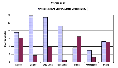
Figure 3. Average Delay
Figures A7 through A10 show the variation that exists among crossings at both borders by plotting delay in minutes across each individual hour of the day. As expected, there are general peaks in activity during normal business hours with the peaks most pronounced with inbound traffic among at southern ports.
Buffer Time and Buffer Index
Table 3 provides a comparison of the differences between the baseline time, the average crossing time, and the 95th percentile time for each port of entry in each direction.
| Crossing | Baseline Time | Average Crossing Time | 95th Percentile Time |
|---|---|---|---|
| Ambassador Bridge Outbound | 5.9 | 8.8 | 13.9 |
| Ambassador Bridge Inbound | 12.9 | 20.4 | 33.9 |
| Blaine Outbound | 4.8 | 21.0 | 35.3 |
| Blaine Inbound | 8.1 | 17.3 | 35.6 |
| Blue Water Bridge Outbound | 4.9 | 6.2 | 9.1 |
| Blue Water Bridge Inbound | 11.1 | 34.2 | 80.3 |
| El Paso Outbound | 5.1 | 9.3 | 34.0 |
| El Paso Inbound | 7.7 | 37.2 | 77.4 |
| Laredo Outbound | 2.2 | 17.2 | 45.0 |
| Laredo Inbound | 12.2 | 31.2 | 54.9 |
| Otay Mesa Outbound | 9.5 | 19.1 | 36.9 |
| Otay Mesa Inbound | 6.3 | 35.0 | 64.3 |
| Peace Bridge Outbound | 9.0 | 21.7 | 38.0 |
| Peace Bridge Inbound | 8.3 | 21.5 | 83.4 |
From these data, a Buffer Time and Buffer Index was developed (Tables 4 through 6) for each crossing, both inbound and outbound, and also aggregated by inbound vs. outbound traffic at both the northern and southern border, and all inbound versus all outbound traffic.
The relationship between these two calculations is perhaps best illustrated in the comparison of all outbound and all inbound crossings in Table 4. The Buffer Time for all inbound crossings is almost twice as large as that for outbound traffic. However, the Buffer Index is slightly larger for outbound crossings than for inbound crossings. In other words, the variability of the 95th percentile time from the average outbound crossing time may be larger, but the impact in real time of the variability in inbound crossings is significantly greater in terms of actual delay.
| Crossing | Average Time[1] | 95th Percentile Time[2] | Buffer Time[3] | Buffer Index[4] |
|---|---|---|---|---|
| All Outbound Crossings | 14.2 | 37.4 | 23.3 | 164.1% |
| All Inbound Crossings | 26.8 | 70.1 | 43.3 | 161.6% |
| All Northern Outbound Crossings | 12.6 | 34.3 | 21.7 | 172.2% |
| All Northern Inbound Crossings | 24.1 | 70.3 | 46.2 | 191.7% |
| All Southern Outbound Crossings | 17.2 | 45.2 | 28.1 | 163.4% |
| All Southern Inbound Crossings | 33.8 | 64.9 | 31.1 | 92.0% |
| Ambassador Bridge Outbound | 8.8 | 13.7 | 4.9 | 55.7% |
| Ambassador Bridge Inbound | 20.4 | 33.9 | 13.4 | 65.7% |
| Blaine Outbound | 21.5 | 35.3 | 14.3 | 66.5% |
| Blaine Inbound | 17.3 | 35.6 | 18.3 | 105.8% |
| Blue Water Bridge Outbound | 6.2 | 9.1 | 2.9 | 46.8% |
| Blue Water Bridge Inbound | 34.2 | 80.3 | 46.1 | 134.8% |
| El Paso Outbound | 13.2 | 34.0 | 24.7 | 187.1% |
| El Paso Inbound | 37.2 | 77.4 | 40.2 | 108.1% |
| Laredo Outbound | 17.2 | 45.0 | 27.8 | 161.6% |
| Laredo Inbound | 31.2 | 54.9 | 23.7 | 76.0% |
| Otay Mesa Outbound | 19.1 | 36.9 | 17.8 | 93.2% |
| Otay Mesa Inbound | 35.0 | 64.3 | 29.3 | 83.7% |
| Peace Bridge Outbound | 21.7 | 38.0 | 16.2 | 74.7% |
| Peace Bridge Inbound | 23.3 | 83.4 | 61.9 | 265.7% |
Notes:
- 95th percentile time – 95 percent of the trucks cross in less than this time.
- Average time – total crossing time of all trucks divided by the number of trucks crossing.
- Average time (in minutes) to travel the study distance (between the starting point in the exporting country and the initial inspection point in the importing country).
- Time (in minutes) for 95 percent of trucks to travel the study distance.
- Time (in minutes) between the average time and the 95th percentile time for trucks to travel the study distance. This is the "extra time" that must be budgeted to cross the border relative to the average time.
- Buffer time necessary expressed as a percentage of average time. This is the extra percentage of average time that must be budgeted to cross the border.
Another point of interest is the difference demonstrated in Tables 5 and 6 relative to inbound versus outbound Buffer Times. Inbound Buffer Times are significantly larger than outbound Buffer Times in the aggregate at 43 minutes versus 23 minutes. The largest single Buffer Time occurs with Peace Bridge inbound traffic at 62 minutes while the shortest Buffer Time is experienced by Blue Water and Ambassador Bridge outbound traffic at 5 and 3 minutes respectively.
| Crossing | Average Time[1] | 95th Percentile Time[2] | Buffer Time[3] | Buffer Index[4] |
|---|---|---|---|---|
| All Inbound Crossings | 26.8 | 70.1 | 43.3 | 161.6% |
| All Northern Inbound Crossings | 24.1 | 70.3 | 46.2 | 191.7% |
| All Southern Inbound Crossings | 33.8 | 64.9 | 31.1 | 92.0% |
| Ambassador Bridge | 20.4 | 33.9 | 13.4 | 65.7% |
| Blaine | 17.3 | 35.6 | 18.3 | 105.8% |
| Blue Water Bridge | 34.2 | 80.3 | 46.1 | 134.8% |
| El Paso | 37.2 | 77.4 | 40.2 | 108.1% |
| Laredo | 31.2 | 54.9 | 23.7 | 76.0% |
| Otay Mesa | 35.0 | 64.3 | 29.3 | 83.7% |
| Peace Bridge | 23.3 | 83.4 | 61.9 | 265.7% |
Notes:
- 95th percentile time – 95 percent of the trucks cross in less than this time.
- Average time – total crossing time of all trucks divided by the number of trucks crossing.
- Average time (in minutes) to travel the study distance (between the starting point in the exporting country and the initial inspection point in the importing country).
- Time (in minutes) for 95 percent of trucks to travel the study distance.
- Time (in minutes) between the average time and the 95th percentile time for trucks to travel the study distance. This is the "extra time" that must be budgeted to cross the border relative to the average time.
- Buffer time necessary expressed as a percentage of average time. This is the extra percentage of average time that must be budgeted to cross the border.
| Crossing | Average Time[1] | 95th Percentile Time[2] | Buffer Time[3] | Buffer Index[4] |
|---|---|---|---|---|
| All Outbound Crossings | 14.2 | 37.4 | 23.3 | 164.1% |
| All Northern Outbound Crossings | 12.6 | 34.3 | 21.7 | 172.2% |
| All Southern Outbound Crossings | 17.2 | 45.2 | 28.1 | 163.4% |
| Ambassador Bridge Outbound | 8.8 | 13.7 | 4.9 | 55.7% |
| Blaine Outbound | 21.5 | 35.3 | 13.8 | 66.5% |
| Blue Water Bridge Outbound | 6.2 | 9.1 | 2.9 | 46.8% |
| El Paso Outbound | 13.2 | 34.0 | 24.7 | 187.1% |
| Laredo Outbound | 17.2 | 45.0 | 27.8 | 161.6% |
| Otay Mesa Outbound | 19.1 | 36.9 | 17.8 | 93.2% |
| Peace Bridge Outbound | 21.7 | 38.0 | 16.2 | 74.7% |
Notes:
- 95th percentile time – 95 percent of the trucks cross in less than this time.
- Average time – total crossing time of all trucks divided by the number of trucks crossing.
- Average time (in minutes) to travel the study distance (between the starting point in the exporting country and the initial inspection point in the importing country).
- Time (in minutes) for 95 percent of trucks to travel the study distance.
- Time (in minutes) between the average time and the 95th percentile time for trucks to travel the study distance. This is the "extra time" that must be budgeted to cross the border relative to the average time.
- Buffer time necessary expressed as a percentage of average time. This is the extra percentage of average time that must be budgeted to cross the border.
There is one final point that further illustrates the potential importance of Buffer Times as a useful measure in assessing crossing times. Table 4 shows average inbound and outbound crossing times for each of the ports of entry surveyed. Among the POE's surveyed, the Peace Bridge shows the most similarity between inbound and outbound average crossing times and is among those crossings at the lower end of spectrum in terms of average time. However, Table 4 shows Peace Bridge with the highest inbound Buffer Index. The significance of these measures taken together is that while the average crossing time is consistent in both directions (see Figure 3), the potential exists to be significantly late in the inbound direction – later, on average, than at any other POE.
From the perspective of the user, the most desirable end is a consistent, predictably low crossing time, a low Buffer Time, which in turn yields a low Buffer Index.
Crossing Volume/Crossing Time Relationships
A scatter plot of each port of entry (Figures A11 through A17) was produced to show volume per hour per lane along the vertical axis and time in minutes along the horizontal axis. The shape of the scatter plots for each port tells an interesting story. With the exception of the Blaine and Ambassador Bridge crossings, as noted earlier, it takes longer to cross the border coming into the U.S. than it does to leave and it is the case that inbound traffic crossing times show considerably more variability without regard to volume. In other words, at a given volume, it's just as likely to take 2x time as it will x time to be processed through the port when coming into the United States. As a general rule, for outbound traffic, it will take less time to cross, and there will be less variability in the time it takes to cross. Note that this is not a function of increased security in the post-September 11 environment as all but one of the surveys was conducted before September 11.
The "ideal" shape of a scatter plot is to have all of the outbound data points groups closely together and all of the inbound traffic data points grouped closely together. Such a distribution would indicate a consistent and reliable crossing time and varying volumes, with the distribution grouped more to the left along the horizontal axis indicating more desirable low crossing times.
Figure A14, the scatter plot of the Ambassador Bridge Crossing comes closest to the "ideal" shape demonstrating a consistently low crossing time for both inbound and outbound traffic. Figure A15, representing the Blaine crossing also shows less time variability compared to other crossings even though crossing times are somewhat longer. At the other end of the spectrum, Figures A11, A12, A13, A16, and A17, (Otay Mesa, , El Paso, Laredo, Blue Water Bridge, and Peace Bridge crossings respectively) have a less desirable distribution of volume/time data points. All, to varying degrees, show a horizontal distribution of points, meaning there is significant time variability across similar volumes.
Monitoring these time/volume relationships in future years and assessing how the shape of the scatter gram changes over time may well prove to be a significant analytical tool in assessing border crossing traffic flows and times. The Travel Time Index and the Buffer Index are measures that summarize these scatter grams.
Time/Volume per Lane/Open Booth Relationships
Not surprisingly, the number of booths open at each port at any given time has a potentially significant influence on travel times and often serves as a leading indicator of that particular variable. Figures A18 through A76 depict the relationship between the volume, travel time, and the number of open booths for each port, each direction, and each day surveyed.
At many ports there appears to be significant variability during the day with respect to the number of booths open at any given time. This relationship is dynamic with volume influencing the number of booths open, the number of booths open influencing traffic volume per lane, and both, to some degree, influencing travel time.
It is important to note three factors with respect to these particular data and their implications. First, as Figures A18 through A76 generally indicate, there is a relationship between the number of open booths and crossing time. Second, decisions with regard to how many lanes are open at any given time are not made purely with mobility/crossing times in mind and are not made by transportation agencies. Third, to whatever degree mobility was a consideration in the number of open booths/lanes prior to the events of September 11, 2001, that level of consideration has lessened.
Implications
Originally, this research was undertaken to document the development of a baseline border crossing dataset. With the tragic events of September 11, 2001, and subsequent changes to the international border crossing operation, the comparability of this data may be diminished or eliminated. However, the knowledge gained about data collection procedures, analysis steps, reporting format, and performance measures will be applicable for subsequent years and other efforts.
This report summarizes the baseline crossing times, delay times, a Buffer Time, a Buffer Index, general patterns of the volume/time relationships, and the patterns of volume/time/open lanes. Each of these factors can be assessed in subsequent years in light of future policy and infrastructure improvements to gauge impact.
With respect to the implications of what is known so far, there are a few clear lessons that can be learned. They are:
- Crossing times at the Ambassador Bridge POE are clearly superior and more consistent than any other port of entry in the study. While, like other ports, inbound crossing times exceed outbound crossing times, the margin of difference is significantly narrower and more consistent. Further, lower crossing times are achieved despite (as indicted in Figure 1) the bridge having a consistently higher volume of traffic. It's not known at this point whether the reason for this difference in performance is a function of policy, bridge ownership, tactics, infrastructure, capacity, or facility design, but clearly, the operations and/or facilities at the Ambassador Bridge port of entry seems to be one worthy of study.
- Three of the ports of entry included in the study (Otay Mesa, Blaine, and Laredo) have some form of "truck only" crossing, with the El Paso crossing (the Ysleta Bridge) being primarily trucks. However, the performance of these crossings as measured as a function of the time/volume relationship did not differ significantly from those crossings where auto and truck traffic are intermingled. This is unexpected and the reasons should be explored.
- It can be generally said that U.S./Canada ports of entry (with the exception of the Blue Water POE) processed inbound trucks in less time and with less variability than did U.S./Mexico ports of entry. There may be procedures/policies that reduce time at the U.S./Canada ports that are transferable to U.S./Mexico ports.
- Prior to the events of September 11, 2001, the perceived threats and levels of concern regarding commerce, homeland security, immigration, and related issues on northern and southern border were different than the environment in that regard after September 11. The extent to which those changes will affect traffic volumes and crossing times in the long term is not yet clear – but certainly the transportation system will be affected. The transportation agencies as well as companies that operate near the border will be challenged to operate as efficiently as possible and adapt to changes that that the inspection and security agencies will implement. The new operating environment may include procedures or technologies that can enhance both security and traffic flow.