Freight Data Tools
Freight data comes from a variety of sources and often presents a major hurdle in completing freight performance and policy analyses. The tools on this page have been developed by Federal Highway Administration and other federal organizations to help users gain quicker insights into freight data.

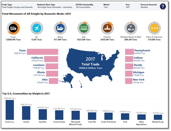
Freight Analysis Framework (FAF5) Data Visualization Tool
This tool is designed to allow users to create and download customized freight dashboards utilizing freight flow origin-destination flow data from the FAF. Tool includes information about the amount and types of goods moved by various modes of transportation between States and FAF regions. Users can select one or more data elements to dynamically generate customized visuals at National, State and FAF zone levels on demand.
USE FAF5 TOOL LEARN MORE
National Highway Freight Network (NHFN) Visualization Tool
This map-based tool allows users to view components of the NHFN on a state-by-state or national basis to learn more information about key freight corridors and their performance across the system.
USE NHFN TOOL
Freight Mobility Trends Tool
This is an interactive dashboard that presents national freight statistics and identify freight highway bottlenecks on the Interstate System, National Highway System (NHS), Primary Highway Freight System (PHFS), and Strategic Highway Network (STRAHNET). It analyzes trends for different freight mobility measures at the national, state, and MPO level and along specific corridors, at bottleneck locations, ports, and intermodal facilities.
- National, State, and Urban Area Freight Statistics: This view provides a national overview of freight performance measures, State, and urban area/Metropolitan Planning Organization (MPO) performance, and a comparison tool to view State and urban area/MPO trends.
- National Freight Bottlenecks: This view provides a ranked list of specific freight bottlenecks nationally or by state in addition to more detailed information. The visualization also includes a separate view of the freight bottlenecks around airports, border areas, intermodal facilities, and ports.
- National Freight Commodity Corridors: This view provides an overview of national freight corridors.
U.S. DEPARTMENT OF TRANSPORTATION
Federal Highway Administration
1200 NEW JERSEY AVENUE, SE
WASHINGTON, DC 20590
202-366-0408
Staff Contact
Tiffany Julien, Transportation Specialist
FHWA Office of Freight Management and Operations
Tiffany.Julien@dot.gov
(202) 366-9241