
Freeway Management and Operations Handbook
Chapter 15 – Detection
and Surveillance
Page 3 of 3
15.2.11 Emerging Trends
A number of trends in technology and application are emerging in the Nation. Some of the traffic sensors noted earlier in this Chapter are gaining more and more application. These include the passive acoustic array, ultrasonic, passive infrared, and the combination sensors. Others technologies and applications show promising results for future implementation.
15.2.11.1 Probe Surveillance
As discussed in Chapter 13 on Traveler Information, it is envisioned that the Integrated Network of Transportation Information (INTI) will not be heavily infrastructure-based; rather, the long-term path is heavily vehicle-based (but not exclusively) for the collection of information. This will require widespread utilization of vehicle probes using GPS and/or cellular phone triangulation, with the result that the standard design considerations of point detection and element spacing along the roadway infrastructure may no longer be applicable. (Note – Probe surveillance using electronic toll tags is not a "cutting edge" technology. In fact, in terms of infrastructure requirements, it is very similar to other "point detection" technologies in that AVI readers are required at selected intervals along the highway to read the tags.)
15.2.11.2 Remote Sensing
Aerial surveillance has long been used to monitor the operation of the surface transportation network. "Observers" in aircraft (fixed wing or helicopters) fly over the freeway and monitor the conditions in real-time, using two-way radios to communicate with the traffic operations center or with service patrols on the freeway. This approach can be relatively expensive when one considers the expense of leasing or operating an aircraft; although it does have the benefit of being able to cover a large area.
An emerging trend is the use of remote sensing via unmanned aerial vehicles, similar to airborne platforms / drones used by the military, and satellites. Information gathered from satellite, aircraft, and unmanned aerial vehicles can be used to estimate arterial and freeway traffic characteristics over long time scales and large geographic areas, including those where data were previously unavailable. The spatial coverage provided from air- and satellite-based sensors can potentially support the development of new metrics that better represent highway utilization and congestion. (1)
Florida DOT is currently experimenting with an unmanned airborne platform that can be programmed to fly a prescribe route and transmit real time video images to a TMC. Other possibilities include the integration of digital video, global positioning systems (GPS) and automated image processing to improve the accuracy and cost-effectiveness of data collection and reduction. A number of experiments have been used to estimate vehicle speeds directly from video images in near real-time by using image registration and edge detection technologies. Similar techniques have been used to derive other traffic characteristics, such as, densities, travel times, delays, turning counts, queue lengths, and platoon dispersion. (15)
15.2.11.3 Networked Video
As technology expands, and the security of the Internet improves, users are looking at cheaper means to distribute video to a wider audience. This audience includes operators, response personnel, emergency service providers and the public. Using the Internet as the communications infrastructure, live streaming video for a wide variety of applications can be distributed to numerous users. With this technology, transportation industry users can utilize their existing CCTV systems to:
- Monitor and respond quickly to incidents
- Monitor critical infrastructure for security purposes
- Archive video for later review for special projects, traffic flow studies, and construction monitoring
- Provide remote access to video for related uses in law enforcement and emergency response
- Create public goodwill by providing video feeds to commuters and media outlets
This capability is available to any user with a standard Internet browser. With excellent bandwidth management, providers can allow hundreds of users to monitor images and provide users with pan, tilt and zoom capability.
15.2.11.4 Maintenance Decision Support System
FHWA is supporting the development of the next generation of road weather information systems called the Maintenance Decision Support system (MDSS) for winter road maintenance decision makers. The program is designed to respond to changing weather conditions and their impacts on the highway system. It was designed with the needs of state Departments of Transportation in mind, and allows winter maintenance managers to:
- View predicted weather conditions throughout the state
- Become aware of the potential for deteriorating road conditions before they occur
- Predict impacts of weather on road conditions
- Plan treatment scenarios based on available resources
- Receive treatment recommendations based on proven rules of practice
The primary goal of MDSS is to get proper weather, road condition, and resource information into the appropriate people's hands so that they can make proactive decisions to manage the transportation system before and during adverse weather conditions.
15.2.11.5 Security
As noted in Chapter 12, another emerging trend is the development and deployment sensor technologies in support of Homeland security – such as devices that automatically and immediately detect potential threats (e.g., stopped vehicles) along the roadways and near transportation centers, and commercial vehicle technology for sensing and identifying hazardous materials.
15.2.12 "Infostructure"
Another emerging trend is the concept of a national "Infostructure". The document entitled "Operating the Highway System for Safety, Reliability and Security; TEA-21 Reauthorization Proposal" (3) includes the following statement: "To provide timely, comprehensive information to managers and users of highway-based transportation systems, a program to implement and operate an information infrastructure or 'infostructure' of traffic and infrastructure monitoring and data sharing is proposed." As discussed herein, the need for an Infostructure (and the associated real time information) exists, as does the technical means to collect and process the associated information. What is missing is the actual deployment. The level of surveillance information currently available is relatively limited. For example:
- Less that 25 percent of the urban freeways in our largest cities are instrumented for traffic surveillance. Moreover, given the current rate of deployment (Figure 15-14), it will be some time before an adequate portion of the freeways in the largest urban areas are instrumented for collecting the information so as to enable truly effective operations and management.
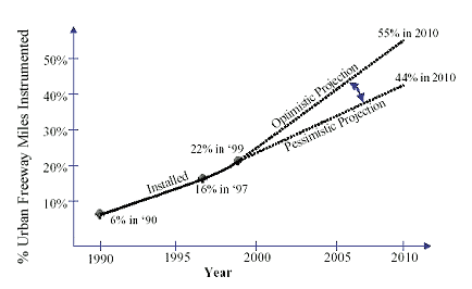
Figure 15-14: Projected Growth in Freeway Surveillance D
- Arterial surveillance is virtually non-existent, mostly involving simple vehicle presence detection for signal control
- Only 25 transit agencies in our 78 largest cities have automatic vehicle location systems on their fixed route buses, and15 percent of all fatal crashes occur during adverse weather conditions, yet road weather data collection stations exist at an average spacing of over 130 miles on the National Highway System.
Moreover, as discussed in Chapter 12, a related issue (and a relatively new concern) is that of homeland security. The ability of the surface transportation network to cope with such contingencies requires additional information and operational capabilities – for example, to identify potential dangers (and then respond) before anything can happen, to detect any such catastrophic incidents, to facilitate first responder access and military deployments, and to effectively route evacuations from major metropolitan areas.
These facts provide compelling evidence that incentives and / or new approaches are required to accelerate the development and deployment of an information infrastructure. The FHWA has recognized this need, sponsoring several efforts to define an initial vision for this Infostructure. Additionally, per the aforementioned paper summarizing reauthorization issues, the "ITS information infrastructure" is identified as "one of the four significant areas of change that are necessary to achieve an adequate emphasis on operations in Federal surface transportation programs.
An initial vision and concept for the Infostructure – a "strawman" view of sorts – has already been developed and documented (12). As currently envisioned, the Infostructure program "would support both national and State/local interests. The national program element would include:
- Statewide (and regionwide) reporting of capacity reducing events on the National Highway System (e.g. crashes, work zones, road weather events) using a consistent reporting format, such as is already being done in the I-95 Corridor Coalition, Arizona, Utah, and a few other States.
- System performance and weather monitoring of freeways, key arterials (including evacuation routes), and transit systems in large metropolitan areas (those with populations exceeding 1 million). This could be accomplished through deployment of electronic monitoring infrastructure, acquisition of data from private sector sources, or a combination of these approaches.
- Monitoring of critical transportation infrastructure (e.g. bridges, tunnels, military routes) for security purposes.
- The State/local element of the program would be focused on producing information for locally determined security, safety and reliability purposes, in order to support traffic management, traveler information, transit management, CVISN (Commercial Vehicle Information Systems and Networks), emergency management, E-911, and security activities and services."
The next step in the process leading to ultimately deploying the Infostructure is the development of a Concept of Operations, which is currently underway at the time of writing this Handbook. Some of the issues to be addressed by the Infostructure Con Ops include the following:
- Highway Classifications & Differentiators: Different types of highways have different operational characteristics. In addition to freeway, arterial, and bridge / tunnel classification, additional differentiators, such as freight routes, evacuation routes, military deployment routes, and routes significantly impacted by snow and other weather conditions, may also impact the type, amount, and accuracy of information required for operations.
- Types of Information: Roadway traffic flow information
– such as volumes, speeds, travel times, etc. – are obvious information
requirements for operating the surface transportation network. Other
conditions and functions can affect the information requirements, including:
- Incidents and Video Surveillance – Incidents reduce the capacity of the roadway and can cause the flow to suddenly breakdown. Moreover, there are other concerns associated with incidents beyond their impact on traffic control, including life safety (e.g., getting medical treatment to injured parties as soon as possible) and environmental (e.g., containing and cleaning up any spills of hazardous materials). Video surveillance has proven very useful for incident verification and "diagnosis".
- Inclement Weather – Capacity and operating conditions may also be affected by inclement weather, requiring information on atmospheric and road surface conditions. This information is also often required to manage winter maintenance activities. The initial Infostructure concept envisions a nationwide "grid" of environmental sensor stations for the purpose of meso-forecasting. The basic information would include atmospheric temperature, humidity, wind speed / direction, and precipitation. Additional information and closer spacing of information collection points (relative to the national grid) may be required depending on a number of factors, including average annual snowfall, level of snow maintenance activities (e.g., anti-icing vs. plowing only), terrain and grades, and spot problems (e.g., fog, high winds, frequent icing). (Note: To date, state transportation agencies have installed over 1,800 ESS nationwide. However, these sensor stations do not provide adequate geographic coverage (e.g., all major road segments) to develop weather information products at the required temporal and spatial resolutions.)
- Transit – An important element of the nation's highway network is the transit buses that utilize the roadways. In addition to monitoring the real-time operations of the roadways, surveillance of the buses themselves (e.g., location, schedule adherence) was also identified as a potential information requirement.
- Security – The horrific events of September 11, 2001 demonstrated the need for information that would help protect critical infrastructure elements, including major highways, bridges, tunnels, and transit systems. Damage or destruction of a major tunnel, bridge or transit facility could cause significant injuries and fatalities, as well as disrupt the transportation system for an extended period of time. Accordingly, the initial Infostructure vision includes surveillance subsystems to monitor critical infrastructure, major transit facilities, military routes, and freight intermodal connectors and terminals to detect problems quickly and reliably and to facilitate rapid evacuation and emergency response if needed.
- Information Integration – In addition to collecting this information, it was determined that the Infostructure should also include some form of statewide and regional integration supporting the exchange and sharing of this information between multiple locations and transportation management centers. This included Statewide reporting of capacity reducing events on the National Highway System (e.g. crashes, work zones, road weather events) using a consistent reporting format.
- Local and National Needs – The Infostructure concept currently envisions supporting both national and State/local interests. The national elements could include the information (and at a level of detail) required to support regional / national travel and to manage major incidents and emergencies – for example: travel time information on freeways and key "interstate" arterial-type highways; weather information; statewide reporting of major capacity reducing events (e.g. crashes, work zones, road conditions); and monitoring of the STRAHNET, emergency evacuation routes, and critical transportation infrastructure. The local element of the program could be focused on producing information for locally determined security, safety and mobility purposes, such as travel time information on "local" arterials, volume information (for input to planning / simulation models), CCTV surveillance, and transit system performance. The distinctions between "national" and "local" may be significant, particularly if they affect funding mechanisms and the respective roles of USDOT, State and local agencies, and the private sector.
- Federal, Public and Private Roles – It is currently envisioned that the Infostructure will not be Federally mandated (in whole) or Federal controlled. Rather, USDOT may provide incentives, and will likely play an oversight and coordination role. The exact nature of the federal role still needs to be addressed, as well as the roles and relationships between the public and private sectors in deploying, operating and maintaining the Infostructure.
At the time of preparation of this Handbook, a "Surface Transportation Security and Reliability Information System Model Deployment" (MDI) was just beginning in the Orlando, FL vicinity.
15.3 Implementation and Operational Considerations
The surveillance subsystem and the information it collects supports the other functions of a freeway management program. The process to select and implement the surveillance subsystem should therefore be based on the information needs of these freeway management functions. Some steps in this process are summarized below.
- Identify and locate operational deficiencies. This involves identifying those freeways that would greatly benefit from the use of surveillance and traffic management. Areas benefiting the most would be those with significant amounts of congestion, safety problems, or potential weather hazards.
- Determine functions to be performed by the freeway management system. This will define the information requirements for the surveillance subsystem. As discussed in previous chapters, potential freeway management functions requiring some sort of data include performance monitoring, simulation and analysis in support of the transportation planning processes, ramp management, lane management and HOV lanes, traffic incident management, special event management, emergency and evacuation management, weather maintenance management, traveler information, etc. At this stage, the focus should still be on what the system will be designed to do, not how it will do it. Therefore, the functions should be defined independent of the available technology. It cannot be overemphasized that the surveillance subsystem provides support to other elements in a freeway management program and traffic management system. Therefore, the functional requirements of a surveillance subsystem are dependent upon the element that it will support. For a surveillance subsystem, the functional requirements typically relate to the type, temporal and spatial frequency, accuracy, and quantity of data required. The data typically used for freeway surveillance have included measures such as volume, speed, and occupancy; however, surveillance should not be limited to these measures only. Additional measures might include travel time, queue length, headway, origin/destination, vehicle classification, etc.
- Inventory existing surveillance capabilities. The
existing surveillance resources should be identified and evaluated to
determine if they are suitable for continued use. The evaluation should
include items such as the detection elements, processors, and communication
infrastructure. It is important to determine if these components can
meet existing needs and if they can accommodate changes in system requirements.
Identify selection criteria. The established performance criteria for
the surveillance subsystem should be related to the needs of the overall
freeway management program and the associated functions. Criteria that
may be used in this regard include:
- Reliability of information collection
- Accuracy of data
- Timeliness of data.
Each of the above criteria is important in measuring the performance of a surveillance subsystem. For example, a system is not effective if it provides accurate data 30 minutes after it is needed.
- Identify / Select Alternative Technologies. There
are a number of alternative technologies available for collecting traffic
data and other information as described in Section
15.2.5. This information can be used as a starting point for identifying
alternative technologies; however, due to continuous technological advancements
and system improvements, available systems and their capabilities are
constantly changing. During the screening process, the following factors
should be considered for each type of surveillance technology included
in the analysis:
- Information provided (vis-à-vis the functional requirements)
- Location of sensors (i.e., embedded or non-intrusive).
- Installation, operation, and maintenance requirements.
- Reliability.
- Expected life.
- Life-cycle costs.
- Communications requirements (bandwidth, media)
- Processing requirements
- Requirements for future expansion.
- Implementation and Testing. Prior to acceptance, the individual units and components that make up the surveillance subsystem should be tested to ensure proper operation, followed by testing of the entire surveillance subsystem.
- Evaluation. After a surveillance subsystem has been
installed, it should be continuously evaluated for its effectiveness
in meeting the freeway management objectives. Providing measures of
traffic operations (e.g., speed, flow, density, etc.). Records should
be kept to track system operations and note any problems. An overall
evaluation of the equipment should include monitoring the following:
- System reliability.
- Ability to provide required data.
- Timeliness of data.
- Accuracy of data.
- Ability to perform under various environmental conditions.
- Operational and maintenance requirements and costs.
- Any other problems with system.
- Reliability of detectors.
- Ability to provide needed data.
15.3.1 ESS and RWIS Deployment
Reference 25 ("Best Practices for Road Weather Management") provides the following overview of issues related to ESS and RWIS deployment. "Several issues must be considered when planning to deploy ESS and implement RWIS. Concerns include procurement and maintenance, data sharing, and institutional issues. Partnerships with neighboring public agencies and the private sector can facilitate data sharing and help defray the initial and recurring costs of field sensors, communications infrastructure, central hardware, and processing software. Another alternative is to fund RWIS component installation as part of larger construction or Intelligent Transportation Systems (ITS) projects. Preventive maintenance funds must also be secured to ensure that sensors are properly calibrated and provide accurate data.
Exchanging environmental data and information with other agencies can minimize surveillance costs. Environmental monitoring networks can be created to collect and integrate data from many sources, store relevant data in centralized databases, and disseminate information in useful formats. Potential data sources include surface weather observation systems deployed by the NWS, the Federal Aviation Administration, the U.S. Geological Survey, the Department of Agriculture, the Forest Service, and the Environmental Protection Agency. The need for redundant infrastructure can be eliminated by coordinating with other agencies.
Another major institutional issue is system acceptance. Potential benefits from ESS and RWIS deployments will not be realized if transportation managers do not use them. The organizational culture, decision-making processes, and technical capabilities of users must be carefully considered during design and implementation. All users desire 'timely, relevant, accurate' road weather information. However, these criteria may be defined differently depending on the operational application. For example, a maintenance manager may consider a 24-hour precipitation forecast 'timely' for treatment strategy planning, while a traffic manager needs real-time snow accumulation data to adjust traffic signal timing parameters. 'Relevant' environmental data is presented to the user in a format that is easily interpreted and suitable for decision support. Software programs must be developed to customize raw data (such as soil temperature) into useful information (such as a pavement temperature forecast based upon air and soil temperatures). Managers have various technological options depending on their weather information needs, operational procedures, and mitigation strategies."
15.4 Examples
15.4.1 TRANSMIT-TRANSCOM System for Managing Incidents and Traffic (Probe Surveillance)
TRANSCOM's System for Managing Incidents and Traffic, known as TRANSMIT, was initiated to establish the feasibility of using Automatic Vehicle Identification (AVI) equipment for traffic management and surveillance applications. AVI technology systems are typically installed at toll booths where they classify oncoming vehicles, then identify them and collect the toll by reading data stored on a vehicle-mounted transponder through wireless communication with a roadside antenna. In the New York City Metropolitan Area, this application of electronic toll collection is called E-ZPassSM.
The current system includes AVI transponder readers installed overhead at approximately 2.4-kilometer (1.5 mile) intervals in both directions of the roadway. The spacing between readers was selected to maximize the probability of incident detection by minimizing the false alarm rate (maximum of 2 percent) and the mean time to detect an incident (maximum of 5 minutes). Twenty-two locations were included in the project with a total of 65 antennas. When a vehicle with the tag passes an antenna, a signal is sent to the roadside equipment and then it is sent by modem over leased telephone lines (along with date and time) to a central site at TRANSCOM headquarters in Jersey City, NJ. The vehicle tag is scrambled to make sure that the vehicle privacy is assured. The data is then processed in the TRANSCOM Operations Information Center (OIC) to derive travel time and to detect incidents. The processed information is sent to similar workstations located at the Tarrytown, NY Office of the NYSTA, and to the New Jersey Highway Authority (NJHA) headquarters in Woodbridge, NJ.
AVI data may be used for producing incident alarms. There is a distinct advantage to the use of toll tags because of their inherent ability to identify and track individual vehicles, a capability that may only be approximated with the use of a loop detector. However, the disadvantage of the use of AVI lies in the fact that the readers, like loop detectors, are essentially point detectors whose effectiveness will be limited by the spacing between successive readers. If detectors are spaced every few yards then it would be possible to track the trajectory of a vehicle and determine, in a very responsive manner, whether the vehicle is stopped. This unrealistically, low spacing would provide a low mean time to detect and a very high probability of detection. Such close spacing is neither realistic nor fiscally responsible. Obviously, the mean time to detect will increase as the spacing of the detectors increases. Recent studies for TRANSCOM have found that readers spaced at 1½-mile intervals on limited access freeways provide the best coverage for obtaining traffic information.
15.4.2 Washington State DOT Road Weather Information for Travelers
The Washington State Department of Transportation (DOT) has collaborated with the University of Washington to provide travelers with comprehensive, integrated road weather information. The DOT maintains one of the most advanced traveler information web sites, which allows users to access current and predicted road weather conditions on an interactive, statewide map.
15.4.2.1 System Components
The DOT owns 50 Environmental Sensor Stations (ESS) that collect air temperature, atmospheric pressure, humidity, wind speed, wind direction, visibility distance, precipitation, pavement temperature and subsurface temperature. Some stations are equipped with Closed Circuit Television (CCTV) for visual monitoring of pavement and traffic flow conditions. The DOT is also a member of the Northwest Weather Consortium, which collects and disseminates real time data from an extensive environmental monitoring network. This network gathers and disseminates data from over 450 ESS owned by nine local, state and federal agencies. A statewide communication network transmits this ESS data to the Seattle Traffic Management Center (TMC) and to a computer at the University's Department of Atmospheric Sciences for data fusion and advanced modeling.
15.4.2.2 System Operations
A sophisticated computer model developed by the university ingests ESS data to determine prevailing and predicted pavement temperatures and generate high-resolution, numerical weather forecasts for the entire state. Observed environmental data is integrated with other information including National Weather Service (NWS) forecasts, satellite and radar images, video from 350 CCTV cameras, traffic flow data from inductive loop detectors, incident and construction data, ten mountain pass reports, and audio broadcasts from four Highway Advisory Radio (HAR) transmitters. As shown in 15-15, route-specific traveler information is disseminated through the DOT's Traffic and Weather web site (www.wsdot.wa.gov/traffic) and via an interactive voice response telephone service (800-695-ROAD). To make travel decisions, the public may access the web site to view state, regional and local maps with environmental observations, weather and pavement condition forecasts, video from freeway CCTV cameras, information on road maintenance operations, and travel restrictions on mountain passes (e.g., reduced speed limits, prohibited vehicle types).
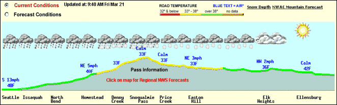
Figure 15-15: Example of Website Showing Current Weather Conditions D
15.4.2.3 Transportation Outcome
Road weather data available through the web site and telephone service allows users to avoid hazardous conditions, modify driving behavior, and reduce crash risk. A user survey found that travelers feel safer when they have access to real-time road weather information. The survey also revealed that users frequently access the web site to prepare for prevailing conditions along a selected route (i.e., 90 percent of respondents), for general weather conditions (i.e., 86 percent), to check weather for a specific recreational activity (i.e., 66 percent), and to determine travel routes or travel time. Usage logs from the web site indicate that travelers access condition data more frequently during adverse weather events. On average, there were over 3,700 user sessions per day in February 2001. During a snowstorm on Friday, February 16th (before a three-day weekend) site usage increased to nearly 13,000 user sessions. The interactive telephone service typically receives one million calls each winter (i.e., an average of 8,000 calls per day) with call volumes increasing during inclement conditions or major incidents. Maintenance managers also benefit from access to detailed road weather data. This data serves as support for operational decisions, such as resource allocation and treatment planning. More effective and efficient resource decisions reduce labor, equipment and material costs. The ability to employ proactive road treatment strategies, such as anti-icing, also improves roadway mobility.
15.4.2.4 Implementation Issues
The web site project was funded by a grant from U.S. Department of Transportation and a 20 percent match from Washington State DOT. To collect environmental data for the site, the DOT wanted to procure ESS from different vendors and display field data on a single user interface. Project managers developed functional specifications and issued a request for proposals to furnish ESS capable of communicating with an existing server using National Transportation Communications for ITS Protocol (NTCIP) standards. After resolving technical issues related to object definitions, one vendor successfully demonstrated that their sensor stations could communication with another vendor's server. This simplified management of environmental data and avoided the need for additional hardware, software and communications infrastructure. By using the open communication standard the DOT encouraged competition among vendors that reduced ESS procurement costs by nearly 50 percent. The NTCIP will also facilitate future expansion of the environmental monitoring system.
15.4.3 Tennessee DOT RWIS
In December 1990, a chain-reaction collision involving 99 vehicles prompted the design and implementation of a fog detection and warning system on Interstate 75 in southeastern Tennessee. The system covers 19 miles including a three-mile, fog-prone section above the Hiwassee River and eight-mile sections on each side.
TMC managers with Tennessee DOT access a central computer system that collects data from two ESS, eight fog detectors, and 44 vehicle speed detectors. By continually monitoring fog and speed sensor data, the computer system predicts and detects conditions conducive to fog formation, and alerts managers when established threshold criteria are met. Highway Patrol personnel visually verify onsite conditions. The computer system correlates field sensor data with pre-determined response scenarios, which include advising motorists of prevailing conditions via flashing beacons atop six static signs, two HAR transmitters, and ten DMS; reducing speed limits using ten VSL signs; and restricting access to the affected highway section with ramp gates.
TMC managers select pre-programmed DMS messages, pre-recorded HAR messages, and appropriate speed limits (i.e., 50 mph or 35 mph) based upon response scenarios proposed by the system. Under the worst-case scenario (i.e., visibility less than 240 feet), the Highway Patrol activates eight automatic ramp gates to close the interstate and detour traffic to US Route 11. (24)
15.5 References
1. Klein, L.A. Traffic Detector Handbook. U.S. Department of Transportation, Federal Highway Administration, Washington, DC. 2003.
2. Klein, L.A., Sensor Technologies and Data Requirements for ITS, Artech House, Boston, MA, 2001.
3. FHWA "Operating the Highway System for Safety, Reliability and Security: TEA-21 Reauthorization Proposal"; 2002
4. J. Kranig, E. Minge, and C. Jones, Field Test of Monitoring of Urban Vehicle Operations Using Non-Intrusive Technologies, FHWA-PL-97-018 (Washington, D.C.: U.S. Department of Transportation, Federal Highway Administration, May 1997).
5. D. Middleton and R. Parker, Initial Evaluation of Selected Detectors to Replace Inductive Loops on Freeways, FHWA/TX-00/1439-7 (College Station, TX: Texas Transportation Institute, April 2000).
6. NIT Phase II: Evaluation of Non-Intrusive Technologies for Traffic Detection, Final Report, SRF No. 3683, Prepared by Minnesota Department of Transportation and SRF Consulting Group, Inc. (Washington, DC: U.S. Department of Transportation, Federal Highway Administration, Sept. 2002).
7. D. Middleton and R. Parker, Evaluation of Promising Vehicle Detection Systems, Research Report FHWA/TX-03/2119-1, Draft (College Station, TX: Texas Transportation Institute, Oct. 2002).
8. J. Grenard, D. Bullock, and A. Tarko, Evaluation of Selected Video Detection Systems at Signalized Intersections: Final Report, FHWA/IN/JTRP-2001/22bbbb (West Lafayette, IN: Indiana Department of Transportation, Division of Research, and Purdue University, Nov. 2001).
9. D. Bullock and A. Tarko, Evaluation of Selected Video Detection Systems at Signalized Intersections: Technical Summary, FHWA/IN/JTRP-2001/22, SPR-2391 (West Lafayette, IN: Indiana Department of Transportation, Division of Research, and Purdue University, Nov. 2001).
10. J. Sturdevant, Video Design Recommendations (West Lafayette, IN: Indiana Department of Transportation, Division of Research, 2003).
11. Weather-Responsive Traffic Management, Concept of Operations (draft); FHWA; Washington, DC. January 2003.
12. Randall, J and Neudorff, L. "Final Summary Report – Information Elements to Support Traffic Management Services". Federal Highway Administration, Washington, DC. Draft submitted to FHWA in December 2002.
13. Wisconsin Department of Transportation. Intelligent Transportation Systems (ITS) Design Manual. Wisconsin Department of Transportation, Madison, Wisconsin. January 2001
14. Mirchandani, P et.al. Application of Aerial Video for Traffic Flow Monitoring and Management.
15. Kraft, W.; "Improved Transportation Management and Operations Through the Use of Remote Sensing"
16. Texas Department of Transportation, Highway Design Division. Operations and Procedures Manual, Part IV, Interim Metric Version.
17. ITS Architecture, Implementation Strategy. Joint Architecture Team: Loral Federal Systems & Rockwell International, Prepared for the Federal Highway Administration, revised January 1997.
18. Sumner, R., Smith, R., Kennedy, J., and Robinson, J. Cellular Based Traffic Surveillance: The Washington, DC Area Operational Test. Proceedings, IVHS America 1994 Annual Meeting, Atlanta, Georgia, April 1994, pp 794–798.
19. Lee, L.K., Zachariah, M., and Everett, P. CCTV Camera Site Selection: A Field Experience. Intelligent Transportation: Serving the User Through Deployment. Proceedings of the 1995 Annual Meeting of ITS America. ITS America, Washington, DC, March 1995.
20. Guidelines for Camera Placement. IVHS/TOS Design Guidelines No. 94-01, California Department of Transportation, District 7, Los Angeles, CA, October 1994 (Revised).
21. Guidelines for CCTV Site Surveying. California Department of Transportation, District 7, Los Angeles, CA, February 1994.
22. Yermack, L., Gallagher, M., and Marshall, K.R. ETTM – An Early ITS Winner. ITE Journal, Vol. 65(12), Institute of Transportation Engineers, Washington, DC, December 1994, pp 42-48.
23. Marshall, K.R.l and Batz, T. The TRANSCOM TRANSMIT Project: An Alternative Approach for Traffic Surveillance and Incident Detection. Moving Toward Deployment, Proceedings of the IVHS America 1994 Annual Meeting, ITS America, Washington, DC, 1994, pp 555-563.
24. Tennessee Department of Transportation Website, 2003.
25. FHWA; "Best Practices for Road Weather Management, Version 2.0"