|
|
|
final report
Traffic Congestion and Reliability:
Trends and Advanced Strategies for Congestion Mitigation
4.0 Congestion Strategies: What Works?
4.1 THE TOOLBOX FOR CONGESTION RELIEF: WHAT CAN WE DO ABOUT TRAFFIC CONGESTION?
Transportation engineers and planners have developed a variety of strategies to deal with congestion (Figure 4.1). These fall into three general categories:
Adding More Capacity – Increasing the Number and Size of Highways and Providing More Transit and Freight Rail Service. Adding more lanes to existing highways and building new ones has been the traditional response to congestion. In some metropolitan areas, however, it is becoming increasingly difficult to undertake major highway expansions because of funding constraints, increased right-of-way and construction costs, and opposition from local and national groups. However, it is clear that adding new physical capacity for highways, transit, and railroads is an important strategy for alleviating congestion.
In those locations where the lack of physical capacity is the greatest contributor to congestion, addition of new capacity is critical. In such locations, the addition of new capacity is critical. Further, the addition of new capacity presents an excellent opportunity to combine it with other types of strategies. This often means that highway designers must think "outside the box" and find creative ways to incorporate new designs and travel alternatives that accommodate the concerns of diverse groups and a variety of system users. Since the worst highway bottlenecks tend to be freeway-to-freeway interchanges, advanced design treatments that spread out turning movements and remove traffic volumes from key merge areas have been developed, often by using multilevel structures that minimize the footprint of the improvement on the surrounding landscape.
Adding new freeways or additional lanes to existing freeways will add large amounts of capacity to the roadway network. However there are other improvements to the transportation system that can reduce or manage congestion, albeit in a more localized area. Widening arterial roads, providing street connectivity, provide grade separations at congested intersections and providing high-occupancy vehicle (HOV) lanes all will help to mitigate congestion. Also, adding capacity to the transit system, whether it is to the bus system, urban rail system or commuter rail system will assist in relieving congestion on the roadway network.
Figure 4.1 A Variety of Strategies, When Used in Combination,
Can Effectively Deal with Congestion
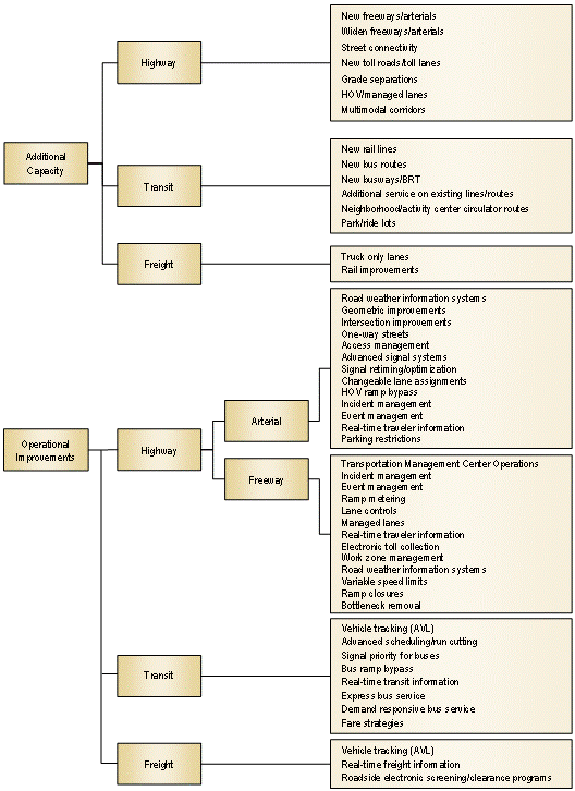
Figure 4.1 A Variety of Strategies, When Used in Combination, Can Effectively Deal with Congestion (continued)
Note: Improvements in italics are those enabled by Intelligent Transportation Systems technology.
Operating Existing Capacity More Efficiently – Getting More Out of What We Have. ("Operational Improvements" in Figure 4.1). In recent years, transportation engineers and planners have increasingly embraced strategies that deal with the operation of existing highways, rather than just building new infrastructure. The philosophy behind Transportation System Management and Operations (TSM&O) is to mitigate the effects of a wide variety of roadway events and to manage short-term demand for existing roadway capacity.
TSM&O includes the application of advanced technologies using real-time information about highway conditions to implement control strategies. Collectively referred to as ITS, real-time control of highway operations through a transportation management center (TMC) has become a major activity undertaken by transportation agencies. ITS control strategies take many forms: metering flow onto freeways, dynamically retiming traffic signals, managing traffic flow during incidents, monitoring transit vehicles in real-time, electronic screening of trucks, and providing travelers with information about travel conditions, alternative routes, and other modes.
In addition to ITS, other TSM&O strategies to improve the efficiency of the existing road system have been implemented, including reversible commuter lanes, movable median barriers to add capacity during peak periods, and restricting turns at key intersections. There are numerous congestion mitigation strategies that are enhanced by the use of advanced technologies or ITS. These strategies are highlighted in italics in Figure 4.1. There are several other effective strategies that do not rely on advanced technology, including geometric improvements to roads and intersections, converting streets to one-way operations and access management.
The idea behind TSM&O strategies is to increase the efficiency of the existing transportation infrastructure. That is, roadway events essentially "steal" roadway capacity and TSM&O seeks to get it back. The deployment of TSM&O strategies and technologies is increasing and evaluations have shown their impact to be highly cost-effective. However, relying on TSM&O alone is a limited approach to addressing the congestion problem. A sound base infrastructure already must exist before TSM&O can be used or TSM&O strategies can be added along with capacity improvements. Also, only so much extra efficiency can be squeezed out of an already stressed highway system.
Improving the efficiency and reliability of the freeway, street, transit, and freight systems is an aspect of the transportation program that in many cases can be accomplished in shorter time, with more public support and at a lower cost than some other strategies. The size of the benefits from any single project may not be of the magnitude of a new freeway lane or rail transit line, but the cost and implementation time also are not as high. One key to understanding the benefits from operational projects is to think of these strategies as enhancing the return on investment in the infrastructure projects.
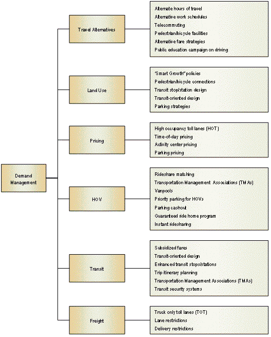
Encouraging Travel and Land Use Patterns that Use the System in Less Congestion Producing Ways – Travel Demand Management (TDM), Non-Automotive Travel Modes, and Land Use Management. ("Demand Management" in Figure 4.1.) Other approaches to the problem of congestion involve managing the demand for highway travel. These strategies include putting more people into fewer vehicles (through ridesharing, increased public transportation ridership, or dedicated highway lanes for high-occupancy vehicles), shifting the time of travel (e.g., through staggered work hours), and eliminating the need for travel altogether (e.g., through telecommuting). The major barrier to the success of TDM strategies is that they require an adjustment in the lifestyles of travelers and the requirements of employers. Flexible scheduling is not simple for many American workers their employers and families, which limits the effectiveness of TDM strategies. Investing in non-automotive modes of travel—such as rail and bus transit systems and bikeways—is another strategy for reducing the number of personal use vehicles on the highway system. These approaches can be an excellent supplement to the highway system, particularly for commuter trips. However, in most metropolitan areas, the level of investment required to meet transportation demand solely through these means is massive and infeasible.
Another approach that is being recently considered in many urban areas is managing demand through pricing schemes. Pricing strategies include charging for the use of HOV lanes either by the number of persons in the vehicle, by time of day, or both. This strategy is known most commonly as "value pricing," but has also been called "congestion pricing" and "peak-period pricing." Value pricing is a way of harnessing the power of the market to reduce congestion and the economic and environmental costs that congestion imposes. For example, since February 2003 the City of London, U.K. has charged a fee for driving private automobiles in its central area during weekdays as a way to reduce traffic congestion and raise revenues to fund transport improvements. This has significantly reduced traffic congestion, improved bus and taxi service, and generates substantial revenues. Public acceptance has grown and there is now support to expand the program to other parts of London and other cities in the U.K.
In the United States, experience with the variably tolled Express Lanes on SR 91 in Orange County, California has clearly demonstrated the ability of pricing to maximize freeway efficiency. The Express Lanes became operational in December 1995. By 1997, congestion had increased on the free lanes as demand increased due to development growth in Riverside County. Analysts have noted that the SR 91 Express Lanes represent only 33 percent of the highway's capacity (i.e., two out of six lanes in each direction), but are carrying 40 percent of the traffic in the busiest peak hours, at speeds of 65 mph versus 10 to 20 mph in the adjacent free lanes. This is due to the fact that congestion results in reduced throughput on the regular lanes, accounting for the higher relative throughput on the free flowing Express Lanes in peak hours.
Land use management is another type of strategy that can influence congestion. The historical cycle of suburban growth has led to an ever-increasing demand for travel. Suburban growth was originally fueled by downtown workers who moved from city centers to the urban fringe to take advantage of lower land prices and greater social amenities. In the past 20 years, businesses also have moved to the suburbs to be closer to their employees and to take advantage of lower rents. This in turn allows workers to live even further away from city centers, thereby perpetuating suburban expansion. To influence these processes, strategies that attempt to manage and direct urban growth have been used in several metropolitan areas. These include land use controls (zoning), growth management restrictions (urban growth boundaries and higher development densities), development policies (transit-oriented design, which provides land use densities and forms to favor transit use) and taxation policy (incentives for high-density development). The main problem with many of these strategies is that they often are contrary to market trends, increasing consumer costs and dampening economic efficiency, at least in the short term. Unless a truly regional approach is followed—with cooperation of all jurisdictions within the region—sprawl may simply be pushed into areas not conforming to growth policies.
4.2 EXAMPLES OF RECENT EFFORTS TO ADDRESS CONGESTION
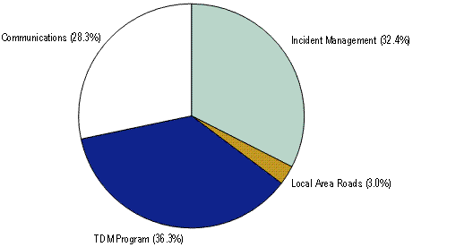
Virginia's Springfield Interchange: Multimodal Approach to Bottleneck Removal. One of the examples of congestion relief performed on a large scale is the approach taken at the Springfield Interchange in northern Virginia. Three different roadways, I 95, I 395, and I 495, come together at the Springfield Interchange. 430,000 vehicles pass through this area daily. A two-year study showed that 179 crashes occurred during that time.20 This improvement project—which will add more than 50 new bridges, add new flyover ramps, and widen Interstate 95 to 24 lanes around the interchange—is expected to take eight years to complete and has a budget of $585 million (although recent cost estimates are closer to $700 million). The construction is currently in its sixth year. In order to alleviate congestion caused by one of the largest construction projects in this nation, $28 million is devoted to the Congestion Management Plans (CMP). Figure 4.2 shows the budget of the CMP divided by the different components.21 The goals of the CMP included removing vehicles from the corridor, responding quickly to traffic incidents, and improving flow on local area roads. Additionally, the CMP aims to enhance alternative commute options and provide information for better traveler decision-making.22 To that end, the CMP is comprised of several demand-side strategies, traffic incident management strategies, local road improvement strategies, and strategies to inform the general traveling public.
Figure 4.2 Springfield Interchange Congestion Management Plan Budget Breakdown
The demand-side strategies for the Springfield Interchange Improvement Project consist of several investments to give travelers alternatives to driving. These strategies were preceded by a commuter research study, conducted using 6 focus groups and 1,500 telephone interviews. Transit options include an expanded commuter rail service, OmniRide bus enhancements, telework centers, and fare discounts for bus and rail service. Some of the rail services have expanded capacity on their trains. Bus service near the interchange is free of charge. Travelers can also take advantage of the promotion of vanpools, carpools, and private buspools of more than 30 passengers. A 10 percent increase of Park and Ride space encourage travelers to use transit. Moreover, CMP also promotes the use of the reversible HOV lanes on I 395 and I 95, which run north and south of the interchange. Furthermore, the Springfield Interchange web site encourages travelers to consider biking or joining the "Guaranteed Ride Home" program.
A traffic incident management component exists in the CMP. A state-of-the-art police mobile command vehicle is located near the interchange. This allows the police to coordinate communication and respond quickly to major traffic incidents. A fire department has a state-of-the-art foam truck available to assist in HAZMAT situations. In addition, the VDOT safety service patrols and state and county police routinely patrol the corridor.
In order to inform the traveling public of how they may be affected by the construction, information is disseminated through the project web site, an information phone line, and other types of media. The two-prong approach to communications consists of a grassroots outreach and advertising. The grassroots outreach involved employers. VDOT informed employers of the partnerships with regional rideshare agencies that could help them implement on-site transportation programs. Speakers bureau and community briefings were also used as mechanisms for informing the traveling public about the impacts of the Springfield Interchange. In addition, communication through advertising includes newspaper, radio, outdoor billboards, periodic newsletters, informational videos, and other collateral materials. Moreover, VDOT has opened a sophisticated Information Center. This is located in a nearby mall and helps to disseminate project information. The storefront station is equipped with cameras monitoring the progress of the project. The store provides information on alternative means of travel, such as ridesharing or transit timetables, and upcoming roadway operational improvements.
Other improvements have been made to local operations and infrastructure around the Springfield Interchange. Adjustments were made to the signals near to the interchange. In addition, turn lanes were added and intersections were improved. The sequence of other maintenance and construction activities in the Springfield Interchange area has been coordinated.
Even though the project has not been completed, some lessons can already be learned about congestion management during major highway improvements. First, budgeting decisions require appropriate expertise at decision-making level to make sure that traffic management and traveler information are incorporated into all phases of the construction. Building trust is essential among the stakeholders of this project. Moreover, the CMP should be planned and budgeted in the design phase. Finally, proactive communication should be included in the CMP.
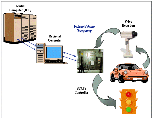
Road Commission of Oakland County (RCOC) FAST-TRAC Project: Advanced Traffic Signal Coordination. Oakland County, located just north of Detroit, is one the largest and most affluent metropolitan counties in the United States. Although its population exceeds 1.2 million Oakland County has a limited freeway system and relies on major arterials, generally spaced a mile apart, for much of its roadway capacity. Opportunities for expanding freeway capacity are very limited due to both financial and environmental considerations. Starting in 1992, RCOC began implementation of the FAST-TRAC (Faster and Safer Travel through Traffic Routing and Advanced Controls) system. The key element of FAST-TRAC is the Sydney Coordinated Adaptive Traffic System (SCATS), an advanced adaptive signal system with the capability to adjust signals on an individual intersection, corridor, and areawide basis. Other key elements are AutoscopeTM video detection cameras installed at each FAST-TRAC intersection and a Traffic Operations Center. Incorporated into the TOC is the Traffic Information Management System (TIMS), which is FAST-TRAC's comprehensive information processing tool. The TOC is able to share data and videos with Michigan DOT's regional ITS center in Detroit. About 600 of Oakland County's 1,300 signalized intersections are currently part of FAST-TRAC. Oakland County also participates in a consortium with other jurisdictions in the area to improve signal coordination for those intersections that are not part of FAST-TRAC.
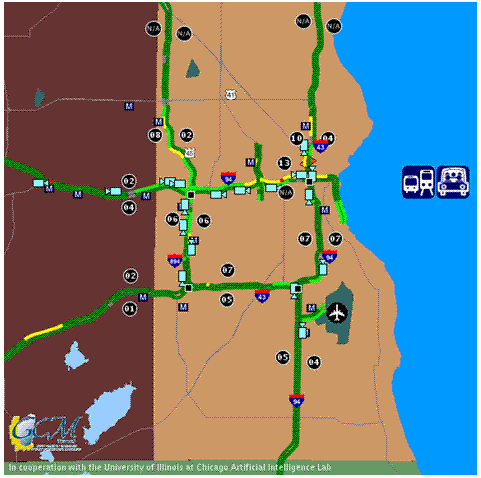
Real-time traffic information is displayed on the RCOC web site and information on freeway conditions and major traffic incidents in the region is exchanged with MDOT's ITS Center. The RCOC web site is unusual in that it provides information on arterial congestion levels. Since describing arterial congestion levels in terms of speed and/or travel time is very difficult, RCOC uses general description (heavy, moderate, light, no congestion) as noted by color. As shown in Figure 4.3, the web site combines local arterial information with MDOT's freeway data. Camera images and DMS messages, both of which are provided by MDOT, can be called up on the RCOC screen. Even though the arterial information is general in nature, this is one of the few web sites in the United States that can be effectively used to plan and assess alternative arterial routes that can be used to avoid freeway incidents and/or congestion.
Figure 4.3 Road Commission of Oakland County Road Condition Web Site Map
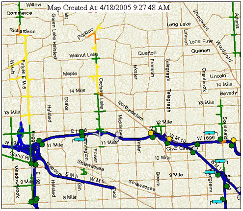
Source: http://www2.rcocweb.org/.
The RCOC generates data that can be used to evaluate system impacts. Since intersections are added to the system on a regular basis, before-and-after studies are feasible. These studies have been limited, however, by lack of funding and available staff time. Several studies have been conducted by academic institutions in Michigan to assess SCATS impacts.
Michigan State University (MSU) conducted a before-and-after study of six intersections in the outlying community of South Lyon. Four approaches were evaluated in detail and showed an overall reduction in afternoon peak-period total stopped delay from 12.6 hours to 10.1 hours.
The percentage of vehicles stopped was reduced significantly at three of the four approaches but increased slightly at the other.23
Highlight Box 3 – How Advanced Traffic Signal Control Works Starting in 1992, the Road Commission of Oakland County began implementing a program to improve traffic flow along arterial roadways. The key element of this program is the Sydney Coordinated Adaptive Traffic System (SCATS). About 600 of Oakland County's 1,300 signalized intersections are now on the SCATS system. SCATS takes advantage of several different technologies to ease the commute for Oakland County residents through improved timing of traffic signals. SCATS intersections are outfitted with video detection cameras. These cameras include computer software that enables them to count the number of cars stopped at intersection, the number of cars going through on green signals and vehicle speeds. This information is sent to a central computer, which compares current traffic flows to trends over the past few years and to traffic conditions at other intersections along the same street. The SCATS computer can then calculate the mix of green and red signal time that will minimize the total time for all drivers on the system. Figure 4.4 SCATS Hardware Structure RCOC's traffic engineers can intervene if necessary. The SCATS central computer is located in a traffic operations center, where engineers can review system and data and observe traffic on Closed Circuit Television (CCTV) cameras. If, for example, a hazardous material spill occurs closing a major street, engineers can intervene to re-route traffic and change signal timing. Studies have shown that the SCATS system in Oakland County reduces overall travel time, the number of red lights where motorists must stop and the length of time they are stopped. In some corridors travel times have been reduced by up to 30 percent during nonpeak hours and up to 15 percent during peak hour. Crash rates were also reduced and those crashes that did occur were less severe in nature. RCOC plans to continue adding intersections to the system. Additional information is available from FHWA arterial management web site: https://ops.fhwa.dot.gov/arterial_mgmt/index.htm. |
An impact study was also conducted on a 3-mile corridor along Orchard Lake Road, one of Oakland County's most heavily traveled and densely developed arterial corridors. This study focused on travel time and intersection delay impacts along the primary corridor and found significant improvements as a result of SCATS implementation. The corridor provided a good location for a before-and-after study since no geometric or physical improvements were made to the intersections. Travel time reductions along the corridor ranged from 7 percent to 32 percent with the greatest improvements coming in the off-peak periods. By allocating green time more effectively, SCATS-related delay reductions along the main corridor were greater than corresponding increases on the cross streets. Both speeds and travel times for through traffic on Orchard Lake Road improved by 7 percent to 9 percent in peak direction. Off-peak direction travel times improved by 7 percent to 20 percent during peak periods and nonpeak travel times improved by 15 percent to 32 percent. Speed improvements showed a similar pattern.
RCOC continues to expand the FAST-TRAC program. While no evaluation studies have been conducted in the past few years, the RCOC has confidence that the program is helping to move traffic more efficiently. A demonstration project currently under design will involve joint management of traffic on the I 75 freeway and Opdyke Road, a parallel arterial. These facilities serve several major traffic generators in Oakland County including Daimler-Chrysler headquarters, the Palace at Auburn Hills (home of the NBA Detroit Pistons) and the Great Lakes Mall. This project will enable RCOC and MDOT to test different operating strategies and measure the impacts.
Wisconsin District 2 Freeway System Operational Assessment (FSOA) Program: Integrated Congestion Relief Strategies. Wisconsin DOT District 2 covers the southeastern portion of the State including the Milwaukee metropolitan area. During the 1990s WisDOT implemented a freeway management system. The freeway management center, field equipment, and central computer system are known as the MONITOR system. Expansion continued into the early 2000s until most of the Milwaukee area's major freeways were covered. The system includes detectors along 130 miles of freeway, 18 cameras located at major interchanges, 20 Dynamic Message Signs, over 80 ramp meters, freeway service patrols, and trailblazer systems to aid in rerouting traffic during traffic incidents, construction, and other emergencies. Figure 4.5 shows a snapshot of the Milwaukee area freeway system traveler information map. The program is coordinated with several other related efforts including WisDOT's statewide SmartWays Program and the Gary-Chicago-Milwaukee Corridor Coalition (GCM).
Figure 4.5 Milwaukee Area Freeway Web Site Map
Source: http://www.gcmtravel.com/gcm/maps_milwaukee.jsp.
The most recent coordination effort involves the Marquette Interchange project, a major reconstruction of the largest and busiest freeway interchange in Wisconsin. WisDOT built upon its existing traveler information system to develop a new web site showing detailed traffic conditions and traveler information through the interchange area.
The FSOA program has also been integrated with two freeway-arterial management projects. One is the Integrated Corridor Operations Project (ICOP) a demonstration project involving joint management of parallel east-west freeway (I 94) and arterial facilities (Layton Avenue) near the Milwaukee Airport. The other was an innovative trailblazer system implemented along the U.S. 45 corridor in the northeast portion of Milwaukee County. Trailblazers were used for real-time diversion of traffic between parallel facilities during a period of major freeway construction.
The FSOA Program was initiated in 1999 in response to increased freeway congestion and a recognition that operational strategies needed to become a permanent part of the District 2 program. In initiating the program WisDOT noted increased breakdown of the system caused by left-hand ramps, increasing demand for access and a financial emphasis on rehabilitation rather than capacity expansion. Capacity expansion projects are generally limited to spot, segment and bottleneck improvements. WisDOT noted two major gaps in switching to this strategy:
- In evaluating the impacts of improvements, systemwide impacts were not being adequately considered. Bottleneck and spot improvements were being evaluated on a case-by-case basis without considering what impacts may occur in other portions of the system. An improvement to one bottleneck, for example, may end up moving the problem to a nearby location with limited or no improvement to the entire system.
- One of the best opportunities to implement operational/ITS strategies is by incorporating them into larger capital projects. Installing ITS equipment such as detectors, cameras, and dynamic message signs is more cost-effectively accomplished while a roadway is under construction. The processes and technical tools to follow through on this strategy did not exist, however.
The FSOA program was implemented to address these gaps by supplying both a process and technical tools for evaluating operational/ITS strategies. In addition to supporting expansion of operational/ITS strategies, FSOA also provides tools to improve existing operational strategies such as ramp metering, construction traffic mitigation and service patrol deployment. Consistent performance measures and detailed technical tools are key elements of the FSOA.
A variety of tools have been used to develop these measures including microsimulation, highway capacity analysis, ramp origin-destination inventory, geographic information systems, and geometric analysis. Microsimulation models have been a major focus of the FSOA effort. A regionwide model using ParamicsTM software is currently being used for evaluation of both operational policies and physical improvements. These models are refined for each application; for example WisDOT is currently updating the model for use in a major improvement study for the I 94 corridor south of Milwaukee.
A recent application of the FSOA tools and data was a WisDOT research project conducted by the University of Wisconsin-Milwaukee and Marquette University. This study evaluated expansion of an existing ramp metering system in the U.S. 45 corridor in northeast Milwaukee County. The purpose of the research was to determine the benefits of ramp meters in the Milwaukee area freeway system, to determine underlying relationships that permit evaluation of new ramp meters or ramp meter systems elsewhere, and to develop a coherent framework for performing evaluation of ramp meter effectiveness on a whole system.
The findings of the study showed that the ramp metering system accomplished its overall objective of improving mobility and safety in the corridor. Some of the conclusions reached by the researchers were:
- Diversion – Drivers react to recurrent delays at ramp meters and along freeway mainlines when choosing between alternate routes. When faced with a long queue at an on-ramp, some drivers divert to another on-ramp while some others avoid the freeway entirely. The U.S. 45 experience suggests that average trip length on the freeway increases when meters are deployed, thereby resulting in less entering or exiting for a given level of traffic on the mainline.
- During the period with new ramp meters in operation the most congested southern part of the analysis corridor experienced an improvement in traffic operations measures of effectiveness, during the most congested afternoon peak period: a substantial reduction in vehicle-hours of travel and increases in travel speeds, under minimal volume changes (a 0 to 2 percent increase) in one of the most congested segments. Speeds increased in this area by 6 percent to 13 percent, and overall by 4 percent during the afternoon peak.
- New ramp meter operation, in conjunction with geometric improvements in ramp merging areas and mainline resurfacing resulted in a 21 percent crash rate reduction for the analyzed corridor during ramp metering hours.
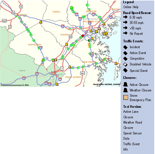
Maryland's Coordinated Highway Action Response Team (CHART): Statewide Traffic Incident Management. Maryland developed the Coordinated Highway Action Response Team (CHART) in the mid 1980s as an effort to improve travel to and from the State's coastal area. Years later, this system has evolved into a statewide operations tool that collects, processes and broadcasts traffic information. Data are collected through a communications infrastructure, a closed-circuit television system, and sensor detection system. The information is then used to make real-time traffic management decisions and provide motorist with information through dynamic message signs, radio travel advisories, and a telephone advisory system. Travelers may also access an interactive on-line GIS mapping service for higher functional classes to obtain average speed, traffic conditions, and lane closures due to weather or construction activities (see Figure 4.6 and 4.7). In addition, travelers can view selected road conditions through on-line video links.
Figure 4.6 CHART's Traffic incident Mapping Interface

Figure 4.7 Sample Drilldown Map from CHART
CHART's ability to detect and manage traffic incidents on major freeways is annually reviewed by the Civil Engineering Department of The University of Maryland at College Park and Maryland State Highway Administration (SHA) staff.24 In 2002, the most recently available performance evaluation report, the CHART/SHA operations responded to 13,752 lane blockage incidents, and provided assistance to 19,062 highway drivers which resulted in a potential reduction of 377 secondary incidents. In addition, CHART patrol units' removal of stationary vehicles and debris prevented 343 potential lane-changing-related collisions and other delays due to rubbernecking.
The result of CHART operational strategies has been a decrease in average traffic incident duration. As Table 4.1 shows, CHART has consistently decreased the average traffic incident duration since 1999. The average duration of traffic incidents with CHART are also notably lower in comparison to traffic incidents without the CHART response program (e.g., CHART resulted in a 27 percent lower average traffic incident duration time in 2002).
| Year | With CHART (Minutes) | Without CHART (Minutes) |
|---|---|---|
| 1999 | 42 | 93 |
| 2000 | 33 | 77 |
| 2001 | 29 | 51 |
| 2002 | 28 | 39 |
A shorter incident duration in turn decreases driver delay, fuel consumption, and emissions. Figure 4.8 illustrates the 29.97 million vehicle-hours "saved" as a result of the 2002 CHART program.
Figure 4.8 Reduction in Delays Due to CHART Operations
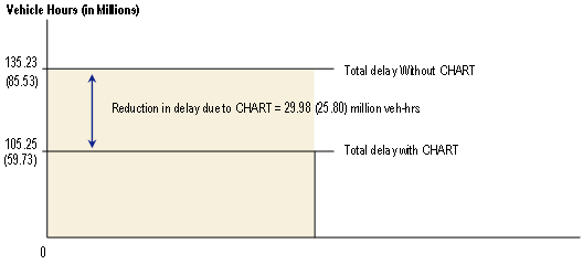
Note: Numbers in parentheses show 2001 results.
Source: Chang, Gang-Len, Ying Liu, Pei Wei Lin, Nan Zou, and Jean Yves Point-Du-Jour (2003).
Performance Evaluation of Chart: Year 2002.
The benefits of the CHART program can also be expressed as monetary savings. Table 4.2 tabulates the total direct benefits from reduction in driver delay, fuel consumption, and emissions. In summary, CHART enabled Maryland to manage its existing infrastructure more efficiently resulting in approximately $468 million in benefits to the traveling public.
| Reduction Due to CHART | Amount | Unit Rate | Dollars (Millions) | |
|---|---|---|---|---|
| Delay (Million Vehicle-Hours) |
29.98 (25.80) |
$14.34/hour | $429.87 ($369.97) |
|
| Fuel Consumption (Million Gallons) |
5.06 (4.35) |
$1/gallon | $5.06 ($4.35) |
|
| Emissions (Million Tons) |
HC | 391.89 (337.3) | $6,700/ton | $33.04 ($28.43) |
| CO | 4,402 (3,788) | $6,360/ton | ||
| NO | $12,875/ton | $6,360/ton | ||
| Total (Million Dollars) | $467.97 ($402.75) | |||
Source: Chang, Gang-Len, Ying Liu, Pei Wei Lin, Nan Zou, and Jean Yves Point-Du-Jour (2003). Performance Evaluation of Chart: Year 2002.
Note: The numbers in parentheses show the result in Year 2001.
Houston's SAFEclear Program: Advanced Traffic Incident Management at the Local Level. Traffic incident management programs that rapidly remove vehicles with mechanical breakdowns or those that have been involved in a collision are an important element of congestion relief programs across the country. Whether the disabled vehicles are on the emergency shoulder or in the travel lanes, they reduce the number of vehicles that can use the freeways. This causes an increase in congestion, travel time and fuel consumed and also increases the possibility of other collisions. These negative effects occur on the roadway where the traffic incident occurred, but also in the other travel direction as drivers slow down to examine the problem area. Incident-related problems are typically identified as peak-period issues, but during off-peak hours, the unexpected congestion not only delays and frustrates travelers, it can also lead to other collisions caused by the unexpected slowdowns. Emergency medical services, fire, police, and other responders are partnering with transportation agencies in many major metropolitan areas to improve safety and reduce congestion using traffic incident management programs.
The City of Houston has taken a particularly aggressive stance in removing disabled vehicles with their SAFEclear Program. The program is an enhanced version of the long-running Motorists Assistance Program (MAP) coordinated by the Transtar Transportation Management Center. SAFEclear uses contracted towing companies to patrol the freeways, identify incidents or respond when called upon, and rapidly remove them to a location off of the freeway (Figure 4.9). Houston Police officers use Transtar's closed-circuit camera network to authorize the tows from a central location rather than the previous on-the-scene requirement. Where MAP used nine trucks to provide services, there are about 60 tow trucks patrolling the 190 miles of freeway in Houston.
Figure 4.9 Houston's SAFEclear Program Has Improved Incident Response Times

Some of the program costs are offset by the fees paid by the tow companies to enroll in the program, and additional funds are being provided by the Metropolitan Transportation Authority as part of its broad transportation operations mission. Tows from the shoulder are free to motorists and the tow companies are provided with a rebate of their initial franchise fee for the service. Long-distance tows or tows of vehicles in travel lanes are paid for by the motorist. The net cost of the program in 2005 is projected to be $2.1 million.
Over the first three months of the program, the tow trucks responded to more than 14,000 stalls and collisions. The response and clearance times for SAFEclear are well under the initial targets for response. Tow trucks responded to more than 89 percent of incidents in less than the 6-minute target. The events were cleared in less than 20 minutes 77 percent of the time. Less than 2 percent of the incidents took longer than 90 minutes to clear. Although the program is relatively new, over the first four months of the program there was a 10 percent reduction in the number of collisions on the freeways compared to the same four months in 2003 and 2004. Comparisons of travel time data from Transtar indicate that travel delay will be 1.8 million hours lower in 2005 than expected given the traffic growth rate. Travel time reliability, as measured by the amount of extra travel time to accomplish a trip during the worst day of the month, also stabilized in 2005 after being 16 percent worse in 2004 than in 2003. Not all of these improvements can be traced to SAFEclear but the improvements in congestion and collisions represent more than $70 million in savings to Houstonians. In addition, vehicle repair and collision paperwork activities are being conducted in places well away from flowing traffic.25
WSDOT's Integrated Operations Programs in the Puget Sound region and Seattle. Managing the transportation system to provide the best service and most efficient use of the limited space is a growing trend in major urban areas. But the Washington State DOT has been aggressively pursuing these kind of improvements for many years. An innovative combination of technology, policies, and resource allocation has provided travelers in Washington with more reliable travel times, fewer collisions, and more efficient use of the available funding.
Key aspects of the approach include:
- Incident management;
- Ramp metering;
- Signal Synchronization/retiming;
- Removing capacity bottlenecks;
- Travel conditions and commute time information;
- High-occupancy vehicle lanes and public transportation facilities; and
- Readily understood performance measures.
The approach concentrates on addressing everyday congestion problems, as well as the weather, collisions or vehicle breakdowns that cause the frustrating variations in travel times as well as safety, environmental and other negative effects. The management approach includes projects and programs, but starts with aggressive action and performance measurement. The improvements in travel time reliability and decline in congestion in some areas of Puget Sound, begin with the adage "Do Something and Measure It." The attitude is reflected in the equipment and personnel assigned to incident response, the technology and attention to adjusting the ramp meters and the incorporation of performance evaluation into operating practices and public communication.
The incident response program was doubled in 2002 and a formal partnership was established between WSDOT, the Washington State Patrol, private tow companies, and a media-sponsored motorist assistance van. This equipment patrols the freeway system in a roving mode and additional vehicles can be dispatched. The reduction in travel times and incident-related congestion is important, but the top priority is safety. Reducing the time that vehicles are stalled in lanes or on the emergency shoulder reduces the possibility of another collision. Evaluations of the incident response program's efforts in removing disabled vehicles indicate a savings of $5,800 in fuel and other operating costs for each incident involving a one-lane blockage and a $7,000 savings in traveler time savings for each incident.26
Freeway ramp meters have been in use in the Puget Sound system for two decades. By providing a regular flow of traffic and lower entering volumes at busy entrance ramps, the meters allow the freeway mainlanes to carry more volume and at higher speeds. The short entrance ramp wait time (average of 2 minutes) is made up for with the shorter freeway travel times. In addition, the greater spacing between entering vehicles has resulted in 30 percent fewer rear-end and sideswipe collisions and lower travel delay. The advanced controllers in the metering system monitor traffic congestion and entering volumes and adjust the metering timing accordingly. The Traffic Systems Management Center operators provide oversight on the system and can adjust the computer systems if necessary.27
I 405 and SR 167 are major commuter routes in the south Puget Sound area. A $10 million project to add a new exit ramp from I 405 to southbound SR 167 reduced the stop-and-go traffic from a nearly 2-mile backup to less than half a mile and increased the traffic volumes handled on the ramp by 8 percent and the mainlanes by 13 percent. Heavy congestion has also been eliminated on the weekends. The total value of travel time savings were estimated at $4.3 million per year indicating that the travel time benefits exceeded the cost of the project in less than 2.5 years.28
Other minor capacity improvements have also been key to maximizing the returns from the roadway investments. The addition of a "weaving" lane between an entrance ramp and exit ramp allows merging and exiting traffic to move more smoothly to their destinations. Where traffic patterns have changed since the initial road construction, a short section of additional travel lane can allow a bottleneck to be relieved and provide a technique that uses road capacity more efficiently. These improvements do not usually eliminate congestion, but they can remove a constriction that causes stop-and-go traffic to begin in one section and spread to others well before most of the roadway has more traffic than it can handle. This is similar to a narrow driveway at the exit from a parking lot. There may be plenty of space on the major street serving the lot, but only a few cars per minute can exit through the one lane leaving the parking area.29
The combination of improved operational treatments and relatively minor capacity expansions are attacking the problem that WSDOT has dubbed "lost productivity." Freeways, for example, carry the highest volume of traffic when speeds are 45 to 50 mph. The lanes are "full"—operating with around 2,000 vehicles per hour per lane—without having so much traffic that drivers feel uncomfortable and slow down. The slow down is what causes stop-and-go traffic to develop and results in traffic volumes less than 1,500 vehicles per hour in each lane at speeds closer to 20 to 30 mph. "WSDOT's goal is to stay on top of the <speed-volume> curve, working toward improving productivity of the system by investing in opportunities that provide optimal throughput."30
Houston's Accelerated Construction of the Katy Freeway: The Systems Approach to Bottleneck Removal. The Katy Freeway (I 10 West in Houston) expansion project is being constructed using an innovative combination of construction and financing techniques. The project, in broad terms, results in a 6 year construction program, (compared to the 12-year original schedule), provides a four-lane tollway in the middle of an expanded freeway, improves the aesthetic and landscaping treatments in the corridor, and rebuilds the existing freeway pavement and bridges.31
The Katy Freeway extends 40 miles from the Central Business District of Houston west to the Brazos River. Constructed from 1960 to 1968 with 6 to 10 lanes, it was designed to carry 80,000 to 120,000 vehicles per day and to have a pavement life of 20 years before major reconstruction would be required. A single-direction HOV lane has since been added in some portions of the corridor for buses, vanpools, and carpools.
The reconstruction program encompasses the middle 20-mile section from near its intersection with I 610 West Loop to the City of Katy. The freeway will have 14 lanes: 4 managed toll lanes, 8 general-purpose freeway lanes and 2 auxiliary lanes. The toll lanes will be separated on each side from the other lanes by a 2-foot buffer and managed with a variable toll to provide high-speed operations. The toll lanes will have 5 access points including the western and eastern ends. The lanes will operate exclusively with an automated toll system. Buses and carpools will use the managed toll lanes with either a discounted toll or at no cost.
The FHWA approved a proposal in 2002 for tolled managed-use lanes in the center of the reconstructed Katy Freeway as part of the Value Pricing Pilot Program currently in operation on the Katy Freeway HOV lane. In March 2003, an agreement was signed to implement the tolled managed-use lanes in the center of the freeway. In exchange the Harris County Toll Road Authority (HCTRA) would purchase the operating franchise for the four tolled lanes for $237 million and another $250 million in in-kind service should they be needed. This funding accelerated the construction time—cutting in half (from 12 to six years) the expected schedule. Without this unique funding arrangement the project, begun in 2003, would have been completed in 2015. With the participation of these entities and acceleration in available funds, the project will be substantially completed in early 2009.
The construction contract has incentive-disincentive clauses that result in few lane or roadway closures and maintain the previously existing number of through-lanes during peak periods. In most cases, the lane and roadway closures are caused by overhead or underground construction that is required by the final road design, not the method or timing of construction.
A significant financial benefit of the accelerated project completion is that the Harris County Tollroad Authority will be able to collect tolls on the four managed lanes in 2009 rather than 2015. Travelers in buses and carpools, currently restricted to a 3-person requirement in the peak hours (2-person requirement during other hours) due to limited capacity in the HOV lane, will be able to travel toll free in the free-flow managed lanes. All travelers will have shorter time periods of congested conditions in the peak, and should have much less stop-and-go traffic in the off-peak. The managed lanes will also provide choices—free, but congested mainlanes, bus or carpool use of the managed lanes for free or reduced price, and a premium pay-for-travel system that allows travelers to determine the importance of their trip and pay for faster, more reliable travel if they wish.
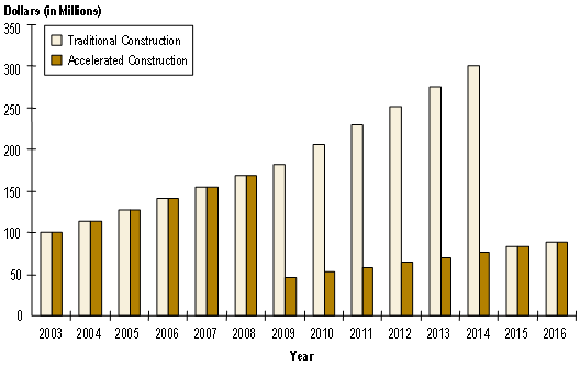
Annual travel delay in 2003, as the project was started, was estimated at 5.1 million person-hours of delay on the Katy Freeway mainlanes and HOV lane. As illustrated in Figure 4.10, the value of that delay and the fuel wasted sitting in congested traffic amounted to just over $100 million. By 2009, without the freeway improvements and with the traffic growth, it is estimated that there will be 9.3 million person-hours of delay and with a time and fuel value of $181 million annually. With the freeway improvements, it is estimated that annual delay in 2009 will be reduced to 2.5 million person-hours with an estimated value of $46 million—an annual savings of $135 million and 6.8 million fewer person-hours stuck in congestion as a result of completion of the project. If the Katy Freeway project were built on the traditional schedule (i.e., with completion in 2015), by the time the project was completed there would be an estimated 16.8 million person-hours of delay and with a time and fuel value of almost $327 million annually. Once the project was completed in 2015, the number of person-hours of delay would be reduced to 4.5 million with a time and fuel value estimated at $84 million. The total value of the fuel and time wasted in congestion over just the six years of early completion is estimated at $1.1 billion.32
Figure 4.10 Cost of Wasted Fuel and Time on Katy Freeway under Alternative Construction Scenarios
Another benefit of the project is its effect on improving the business climate by providing lower travel times for raw and finished good shipments, lower service and delivery costs, and more efficient use of personnel. An FHWA-sponsored study by Nadir and Ammines estimated the value of these benefits as a 16 percent annual return on an initial transportation capacity investment.33 For the Katy Freeway project, a more conservative 12 percent return was used. The benefit associated with the six-year acceleration is estimated to be between $1.2 billion and $1.8 billion over the 2009 to 2015 period.
The cost premium to obtain the accelerated construction schedule included several components. Right-of-way and utility relocation costs have exceeded initial estimates due to the more rapid schedule. The cost of contractor incentives are also included in the cost premium. Reducing the construction schedule also has cost benefits, however, as the typical construction cost inflation will not be seen in the construction bids. The net cost increases are estimated at between $80 million and $265 million.25
In sum, the benefits of accelerating construction, reducing construction effects on travelers and businesses and improving the transportation system in west Houston are between $2.2 billion and $2.9 billion for the six-year period from 2009 to 2015. This represents a benefit/cost ratio of between 8:1 and 36:1 if only the six-year accelerated period is analyzed and only the differential construction costs are used. The accelerated construction schedule reduces the effects of construction activity, but it also significantly improves the quality of life and the viability of businesses. In this case, an innovative financing scheme has created a better transportation product, faster.
The Katy Freeway expansion project combines an innovative financing strategy, attention to traffic problems during construction and an accelerated construction schedule to improve the west Houston transportation network. The Harris County Tollroad Authority is essentially purchasing the new four-lane toll and high-occupancy vehicle facility from the Texas DOT. The $237 million HCTRA purchase price provides more funds early in the construction period than the typical state DOT project allowing the project to be completed sooner, mobility to be improved earlier and the frustration of driving through, and living with construction reduced.
4.3 PROMISING CONGESTION RELIEF STRATEGIES ON THE HORIZON
In addition to innovative projects that have already been implemented, a number of even more advanced technologies and integrated programs are in development. These programs and technologies offer great promise for addressing congestion problems in the near future. A review of several such programs and technologies follows.
iFlorida: Tested for the Next Generation of Operations Strategies.34 In March 2003, the Florida Department of Transportation (FDOT) was selected to participate in a highly innovative model deployment of operational strategies with FHWA. Named iFlorida, this project is based on the idea that advanced operational strategies require highly detailed traffic condition data over a wide area. Therefore, the initial stages of the project are to deploy additional traffic surveillance equipment to augment Florida's existing information infrastructure. Once in place, the infrastructure will be used to demonstrate the wide variety of advanced operational functions to enhance traffic flow and improve security, including:
- Advanced Weather Information – Numerous sources of weather information, current and forecasted, are available and will be increased through iFlorida. This project takes these multiple sources as input and develops very specific current conditions and forecasts for individual roadway segments for major Florida highways; these are time-sliced forecasts (15-30 minutes) of weather and road surface conditions for each segment.
- Security Monitoring Command and Control – This element will provide a monitoring capability for sensors and video at two high-priority bridges in Florida: 1) the Fuller Warren Bridge on I 95, which serves as a bypass route for Jacksonville and 2) the St. Johns River Bridge serves as a major I 4 route between Daytona Beach and Orlando. Each of these facilities will have a 24/7 operations and monitoring capability.
- Variable Speed Limit Trial – Twenty-two static speed limit signs on I 4 will be replaced with variable speed limit signs, giving FDOT the capability to adjust speed limits to match current conditions. One likely application will be during the reconstruction of the I 4 and SR 408 interchange, which will begin in 2005. Other applications, such as reducing speed limits during adverse weather or when an incident occurs, have also been discussed.
- Roadway Diversion Information – In Orlando, the expansion of roadway surveillance to include not just freeways but signalized highways as well opens up expanded possibilities for providing traveler information. FDOT plans to use existing DMS to provide travelers with comparative travel time estimates from the iFlorida deployment at locations where alternate route choices are available.
- Statewide and Central Florida Traveler Information Web Sites – Likewise, expanded surveillance coverage of traffic conditions statewide allows richer data to be passed onto the traveling public.
- On-Board Video Surveillance on Orlando City Buses – Real-time feeds from operating buses allow increased security for passengers.
- Evacuation Operations – The expanded surveillance and communications backbones of iFlorida will be used to support evacuations. This will include decision support on where and when to implement contraflow traffic operations and to identify major problems along evacuation routes, and to provide information to travelers on current conditions and alternative routes. iFlorida information will be used to enhance the functioning Florida's Emergency Operations Center, especially the Hurricane Evacuation and Decision Support Utility Program (HEADS UP) being developed by the Florida Division of Emergency Management.
Integrated Corridor Management ITS Initiative. Recognizing the importance of maximizing the operational effectiveness of an entire corridor, the U.S. DOT's ITS program includes "Integrated Corridor Management" (ICM) Systems as one of nine Major Initiatives. The basic premise behind the ICM initiative is that these independent systems and their cross-network linkages could be operated in a more coordinated and integrated manner resulting in significant improved operations across the corridor. As stated in the ICM vision, "metropolitan areas will realize significant improvements in the efficient movement of people and goods through aggressive and proactive integration and management of major transportation corridors." In essence, integrated corridor management consists of the operational coordination of specific transportation networks and cross-network connections comprising a corridor, and the coordination of institutions responsible for corridor mobility.
The goal of the Integrated Corridor Management Initiative is to provide the institutional guidance, operational capabilities, and ITS technology and technical methods needed for effective Integrated Corridor Management Systems. Currently, the ICM initiative consists of the following four phases:
- Foundational Research – Working with multimodal stakeholders, develop an understanding of the institutional, operational, and technical integration needs and issues of developing and deploying an integrated corridor management system. Phase 1 activities include developing definitions; identifying corridor types, operational approaches and strategies, and the associated integration requirements; reviewing existing and simulated corridor operations; and developing initial guidance for "ICM Planning and Implementation," including a Concept of Operations for a generic corridor.
- Operations and Systems Development –Based on the Phase 1 findings, structure the development phase to address the corridor ITS integration issues that may include alternative shared operations management schemes and cross network operations strategies. Modify or develop analytical tools and methods that will enable the development and evaluation of integrated corridor management strategies. This phase also includes laboratory and limited field-testing of component integration interfaces and component operations of an integrated corridor management system.
- Model Deployment – Candidate model deployment sites will be selected with a "request for application" process. These candidate model deployment sites will become key members of the ICM Stakeholder group and be provided funding and support to develop a site-specific Concept of Operations for their proposed corridor. The final model deployment site will be chosen from the candidate sites at a later date. The selection will take into account each site's ability to demonstrate the ICM concept and successful implementation of an ICM system. The model deployment will demonstrate the application of institutional, operational, and technical integration approaches in the field, and document implementation issues and operational benefits. An independent evaluation will be conducted to document the results.
- Knowledge and Technology Transfer – Formal technology transfer efforts will be initiated to disseminate the knowledge gained from Phase 1 and Phase 2. Towards the end of the model deployment effort, those outreach activities will provide guidance and transfer the tools and technologies needed to support successful integrated corridor management strategies.
U.S. DOT is currently working with stakeholders to identify the ICM institutional, operational, and technical integration issues; and revise the program to address these issue and support stakeholder implementation needs. U.S. DOT is also developing a Model Deployment/ICM Demonstration approach. The innovative approach provides for the joint development of Model Deployment/ICM Demonstrations. The U.S. DOT will work with stakeholders to collectively craft what can be done to effectively demonstrate how ICM can be implemented and its operational benefits.
Clarus Initiative: Roadway Weather Information. Clarus (which is Latin for "clear") is an initiative to develop and demonstrate an integrated surface transportation weather observation data management system, and to establish a partnership to create a nationwide surface transportation weather observing and forecasting system. The objective of Clarus is to enable weather service providers to provide enhanced information to all road, rail and transit managers and users to reduce the effects of adverse weather (e.g., fatalities, injuries, and delay). The Clarus Initiative aims to demonstrate how an open, integrated approach to observational data management can be used to consolidate surface transportation environmental data. Surface transportation environmental data assimilated by the Clarus system will include atmospheric data, pavement and subsurface data, as well as hydrologic (water level) data. All of these types of data and information are referred to as "environmental data" and "environmental information" in this paper.
Clarus is a joint effort of the U.S. DOT ITS Joint Program Office and the FHWA Road Weather Management Program, which resides in the Office of Transportation Operations. The Clarus Initiative has four primary motivations:
- Provide a North American resource to collect, quality control, and make available surface transportation environmental observations so that state and local transportation agencies can be more productive in maintaining safety and mobility;
- Support real-time operational responses to weather events and weather impacts through the collection of surface transportation environmental observations;
- Enhance and extend the existing weather data sources that support general purpose weather forecasting for the protection of life and property; and
- Integrate surface transportation environmental observations with existing observation data to support the enhancement and creation of models that make better predictions in the atmospheric boundary layer and near the Earth's surface to support more accurate forecasts.
The Clarus Initiative consists of two development components. The first component is the Clarus system—a network for assimilating and exchanging quality-controlled environmental data related to surface transportation. The second component is the creation of tailored tools (e.g., decision support systems, route-specific forecasts) that make effective use of Clarus system data. Such tools will illustrate the utility of these data sets and provide the genesis for new and enhanced environmental information products for the surface transportation community.
Goal-Oriented Planning Processes: Expanding on the Traditional Planning Process. Long-range regional transportation plans are visions of the future. Current Federal planning regulations require that the plans identify funding sources for all projects, programs, or strategies within the plan. All urban regions have other projects that they would like to pursue if funding were available. The major metropolitan areas in Texas and Atlanta, Georgia have developed a more extensive process for quantifying the need for other projects and estimating the costs and the benefits of action. While the efforts differ in several ways, they point to an expansion in the role of planning and a more active discussion about the role and importance of transportation in urban America.
The discussion about the projects that should be pursued, how those should be implemented and benefits of additional funding will require more than a single plan, funding amount or set of ideas. The public and decision-makers must be engaged in the dialogue so that the amount of funding and the potential for additional user fees, changes to policies or additional services can be discussed along with the benefits of those programs.
The Texas Metropolitan Mobility Plan has a goal of eliminating serious congestion from all travel corridors in the eight largest population centers. The long-range transportation planning models in each area were used to estimate the capacity improvements required to accomplish this goal. The capacity costs were estimated using roadway construction costs, but the actual combination of projects, programs, and policies will not be identified until the corridors are studied in more detail. What the TMMP did accomplish, however, is to provide additional information to the decision-makers and public about the beneficial effect of additional transportation spending and allow a more informed discussion about the choices faced by residents.
The goals set in the Texas Metropolitan Mobility Plan are an important element of the plan. A measurable goal provides a clear way to identify progress and needs beyond current financial capability. Goals might include congestion and reliability performance goals that can be used to evaluate current systems as well as the longer-term scenarios. Access to jobs and other destinations are also relevant and can be identified using the long-range travel model output. The goals may also need to be related to other areawide targets such as population and employment growth, home prices, education quality, etc.
Atlanta's Aspirations Plan, one component of the Mobility 2030 process, the region's long-range plan efforts used a more detailed planning approach that included several factors—congestion relief among them—to select projects that were beyond the ability of the currently identified funding sources. The long-range planning model was modified to include estimates of the effect of operational improvements for roadways and public transportation in the performance measures to provide a comprehensive view of system characteristics. A prioritization process was used to select the important projects and programs beyond the regional plan and a preliminary cost estimate was developed for each. The Aspirations Plan included several sets of land use and transportation system options. The investment "portfolios" included more road and public transportation capacity, improved operations, demand management, land use pattern changes and pricing projects.
The Atlanta Aspirations Plan and the Texas Metropolitan Mobility Plan allow consideration of a broad set of transportation and land use choices. Analyzing a range of project costs and the congestion resulting from those solutions provides more information for public discussion. The projects, programs, and strategies,, the methods to finance the strategies and the path to achieving desired outcomes are more explicitly identified. Using the long-range transportation models to analyze the effect of land use options and transportation strategies allows the community to see the effect of those choices. The techniques being developed in these evolving efforts are providing the basis for a very robust analytical and communication process.
- Springfield Interchange Improvement Project web site: http://www.springfieldinterchange.com/pb.asp.
- Springfield Interchange Improvement Project Presentation to 2001 VASITE and ITSVA Joint Annual Meeting – June 28, 2001.
- Presentation to Northern Virginia Transportation Commission: Potomac and Rappahannock Transportation Commission – Joint Meeting, May 6, 1999.
- Final Report on the Analysis on the Impact of Installing SCATS in South Lyon – FAST TRAC Phase III Deliverables, Underwood and Demski, University of Michigan).
- Chang, Gang-Len, Ying Liu, Pei Wei Lin, Nan Zou, and Jean Yves Point-Du-Jour (2003). Performance Evaluation of Chart: Year 2002.
- Program Evaluation. Preliminary Data Analysis, Rice University and Texas Transportation Institute, May 2005.
- Measures, Markers and Mileposts. The Gray notebook for the quarter ending March 31, 2003. Washington State Department of Transportation's quarterly report to the Washington State Transportation Commission: http://www.wsdot.wa.gov/ accountability/Archives/GrayNotebookMar-03.pdf.
- Measures, Markers and Mileposts. The Gray notebook for the quarter ending September 30, 2004. Washington State Department of Transportation's quarterly report to the Washington State Transportation Commission on Transportation Programs and Department Management: http://www.wsdot.wa.gov/accountability/Archives/ graynotebookSept-04.pdf.
- Bremmer, D., Cotton, K.C., Cotey, D., Prestrud, C.E., and Wesby, G. Measuring Congestion: Learning from Operational Data. Paper prepared for Transportation Research Board, March 2004.
- Bremmer, D., Cotton, K.C., Cotey, D., Prestrud, C.E., and Wesby, G. Measuring Congestion: Learning from Operational Data. Paper prepared for Transportation Research Board, March 2004.
- Measures, Markers and Mileposts. The Gray notebook for the quarter ending September 30, 2004. Washington State Department of Transportation's quarterly report to the Washington State Transportation Commission on Transportation Programs and Department Management: http://www.wsdot.wa.gov/accountability/Archives/ graynotebookSept-04.pdf.
- http://www.katyfreeway.org/index.asp.
- Texas' Roadways – Texas' Future. A Look at the Next 25 Years of Roadway Supply, Demand, Cost and Benefits. Governor's Business Council, Updated 2005.
- Nadiri, M.I., and Mamuneas, T.P. Contribution of Highway Capital to Output and Productivity Growth in the U.S. Economy and Industries. Federal Highway Administration, August 1998. Available at: https://www.fhwa.dot.gov/policy/gro98cvr.htm.
- http://www.iflorida.net/.
Previous | Table of Contents | Next