Work Zone Operational Enhancements Integrating ITS into a Design Build Project
Arizona State Route-68
By Alan Hansen
FHWA Arizona Division
Supported by: Debra Brisk and Jennifer Livingston
Arizona Department of Transportation
State Route 68 (SR-68) is located in northwest Arizona and runs between Kingman and Bullhead City. The SR-68 project starts at about the mid-way point of SR-68 and extends to Bullhead City. The SR-68 project is a $42 million project covering 13.5 miles. The scope of the project is to reconstruct the existing 2-lane highway into a 4-lane divided facility. This is a very rural corridor cutting through both high desert landscape as well as the Black Mountains. Although this is a rural corridor, this route is considered a major commuter route for people traveling between Kingman, Bullhead City, and Laughlin, Nevada. In addition to the commuter traffic there are also 6% trucks and significant recreational users that travel the corridor. SR-68 serves as the alternate route for the Hoover Dam. With the Hoover Dam being closed to truck traffic since September 11th, 2001 this route is even more critical. The Arizona Department of Transportation (ADOT) wanted to minimize the delay to all the motorists on a day-to-day basis. This has resulted in two unique features on this design/build project. The first is a motorist assist patrol and the second is a travel-time system incentive program. Both of these programs were brought about by the efforts of the ADOT’s Kingman District Engineer - Debra Brisk. This report documents a site visit taken with the ADOT Resident Engineer - Jennifer Livingston and provides the status of these operational enhancements with the project approximately 35% complete. The project has a revised completion date of Spring 2002.
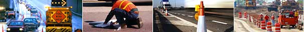
Motorist Assist Patrol
The purpose of the motorist assist patrol (MAP) is to keep the roadway clear, identify incidents and maintain smooth operations. The contractor operates the MAP from 4pm to 6am on weekdays and around the clock on weekends and holidays. The contractor hired a private security guard service to operate the MAP vehicles. While the drivers of the MAP vehicles are trained as security guards, they dress in typical construction type clothing including hard hats and vests. Based upon discussions with the ADOT Resident Engineer, the contractor felt that hiring trained security guards would make it a safer environment for the MAP drivers.
The MAP is equipped with traffic control devices, water, gasoline, flares and lighted arrow boards. The MAP had assisted 945 stranded motorists in the corridor through February 2002. The majority of the travelers were stranded due to mechanical failure, 641 of these were able to get back on the road just with the assistance of the MAP. The MAP also assisted an additional 230 motorist to get outside assistance such as towing or a service truck. It is generally believed that the mechanical failures experienced in the corridor are related to the high temperatures and the 6% grade through much of the project.
Travel-Time System Incentive Program
The State Route 68 Design/Build project has also implemented a Travel Time System that measures speed consistency and performance through the construction work zone. The length of the SR-68 project is approximately 13.5 miles. Prior to construction, the average travel time for this segment, which has a posted speed limit of 55 MPH, was 17 minutes. During construction, traffic control measures, and reduced posted speed limits of 35-45 MPH have increased the corridor travel time to approximately 21 minutes. The contract for the project included a provision that during construction the travel time could not exceed an average of 27 minutes. The contract provided for a $400,000 travel time budget item that would be drawn against if the target travel time average was exceeded. The incentive of this provision was that at the end of the project any funds still in the travel time budget would be profit for the contractor. Should the contractor not be able to maintain the target travel time during construction, it is possible for the entire funds in the travel time item to be used and the item would then turn into a disincentive where the contractor would be responsible for paying for the added delay.
The contractor was also responsible for determining the best way for measuring the travel time through the project. The contractor chose to deploy a license plate reader system developed by the British company Computer Recognition Systems, which has a United States headquarters in Boston. This system uses a camera and a light source to capture license plate images of passing vehicles. The license plate number is taken from the picture by image recognition software, encrypted, then sent to the central computer at the contractor’s office through a high-speed data connection. The system is optimally designed to capture license plate readings at 45 to 55 MPH. There is a second camera at the end of the project, which takes a second picture, encrypts that license plate number and sends it to the central computer. The central computer then attempts to match up license plates that enter and exit the limits of the construction project. There are cameras at the entrance and exit of the project in both directions providing for a total of four cameras on the project. Other technologies considered for the travel time system included radar systems that would be deployed throughout the corridor and give single point traffic speeds but would not offer direct measurement of corridor travel times.
The cameras have been mounted behind construction signs to keep from distracting the motorist. Each of the four locations includes a camera on one sign assembly and a light on a second sign assembly. The light and camera are then positioned to capture license plate readings on passing vehicles. The license plate readings are encrypted and continuously sent back to the contractor’s central computer on a high-speed data connection. None of the license plates numbers are recoverable after the encryption process to honor the privacy of the motorist. The light is needed to assist in reading the license plates, including being able to read through the plastic covers that are installed over the license plate by some motorists. The system operates 24 hours a day. The general lay out of the cameras and light are shown in the following pictures. The first picture shows the signs that the camera and light are mounted behind and the second picture shows the actual equipment.
To date the contractor has experienced very few times when the average travel time goal has not been met. This has resulted in only about $2,000 being drawn out of the travel time item. The license plate reader system is able to match around 11% of license plates between the start and finish of the project. The license plate match rate is influenced by the system reading only one lane of traffic yet there are two lanes of traffic at the location of both the license plate readers. This rate is considered good compared to other license plate reading projects around the world and is adequate for the average travel time estimates used on this project.
The license plate reader system has experienced some issues. Early in the project there were some complaints that the light was distracting to motorists traveling in the opposite direction of the camera/light placement. These complaints were resolved by better light placement, the motorist becoming accustomed to the lights being there and public outreach and education. These lights are not as bright as regular construction zone lighting. One of the cameras was also stolen. This has resulted in the contractor welding the cameras to the sign structure and installing a chain locking system. As the construction proceeds and travel lanes are moved, the cameras and lights must be adjusted so the license plates of the cars are still clearly in the field of view. Some privacy concerns were raised at the start of the project, however the central computer does not maintain any of the license plate numbers after they have gone through the initial encryption process. This has eased the privacy concerns. The license plate reader system is also fairly expensive to operate. The system requires high-speed data connections, which cost about $700/month for a T1 line and about $200/month for a wireless connection. There is also a monthly electricity cost of approximately $100/month. At the end of the project the license plate reader system will be the property of the contractor.
Summary
Both of these programs have helped to make the State Route 68 project a model for innovative work zone features. The motorist assist patrol has helped many stranded motorists. ADOT has provided comment cards to the motorist who have been helped by the patrols and have received a survey return rate of nearly 50 %, all of which have made positive comments about the patrols. Clearly this program is very popular with the traveling public. The travel time incentive program is not as visible to the traveling public but they are still enjoying the benefits. Due to this program, the contractor has made great efforts to limit the delay to people traveling the corridor. The contractor has made sure to limit the number of flagging stations throughout the project and has scheduled work in such a way that it reduces the impacts to the public. ADOT has made extensive efforts to communicate with the public regarding this project. Their public outreach efforts have included public service announcements, cable television announcements, a speakers bureau, radio media alerts and an established website (www.highway68construction.com). These forums have allowed for public input into how the project is perceived by the motorists who use the corridor and the general findings are the public feels that the construction work zone has not significantly affected travel through the corridor. Work Zone programs such as these help to limit the delay to the public, improve transportation system efficiency, increase work zone safety and provide a better working relationship between the State DOT, contractor and the community.