Traffic Analysis Tools Volume IX: Work Zone Modeling and Simulation
A Guide for Analysts
Nova Scotia Department of Transportation & Public Works (Canada) Reeves Street
Nova Scotia Department of Transportation & Public Works (Canada)
Reeves Street[10]
| Work Zone Characteristics | |
|---|---|
| Transportation Analysis: | |
| Approach | Sketch-Planning |
| Modeling Tools | QuickZone |
| Work Zones: | |
| Type | Type III |
| Network Configuration | Isolated |
| Geographic Scale: | |
| Work Zone Size | Small |
| Analysis Area | Local |
Overview
Nova Scotia is one of Canada's Atlantic maritime provinces located on the east coast with a provincial population just under 1 million. Nova Scotia is composed of several islands and peninsulas with key commercial and population centers connected by the Trans Canada Highway. Port Hawkesbury is a key commercial location on Cape Breton Island just south of the Trans Canada Highway. The town of Port Hawkesbury includes a number of major industrial facilities representing companies such as Georgia-Pacific, Statia Terminals, USG, and the Sable Offshore Oil Company. The town also includes a number of residential communities.
In 2001, the intersection of Reeves Street and Trunk 4 in Port Hawkesbury, a location along a key access route to the Trans Canada Highway, was slated to be upgraded. Both Reeves Street and Trunk 4 are generally 2-lane highways with certain sections upgraded to include designated turn lanes in built-up areas. Average Annual Daily Traffic (AADT) was on the order of 8,000 vehicles per day with approximately 10% of those being trucks. Truck traffic is concentrated during the daytime on weekdays, while trucks make up fewer than 5% of traffic volume on weekends. Most of the traffic volume at this location in Port Hawkesbury is through traffic continuing on to some of the industrial centers near the town or to points further north.
The reconstruction involved a major upgrade of the intersection including additional dedicated turn lanes to accommodate higher traffic volumes and to improve safety. In order for construction to take place, overall capacity of the intersection would be reduced due to narrow lanes widths and periodic lane closures. Construction was slated to take place only during daylight hours because of cost and safety concerns. However, it was also evident that any construction taking place during the day would have an impact on motorists, since the Reeves Street/Trunk 4 intersection carries a large amount of traffic. Therefore, in order to reduce the impact to motorists as much as possible, a sketch planning traffic modeling tool was used to test various construction phasing alternatives, including analyzing the possibility of a detour route, and to also provide the necessary data to justify the additional expense of night work.
Work Zone Characteristics
Reeves Street intersection is a fairly basic design and consists of the signalized intersection and a detour route as shown in the figure below. Reeves Street ends at a “T” intersection with roads Trunk 4 and Trunk 4a to the left and right. The left turning movement continues on to Trunk 4 and carries a majority of the traffic volume. The right turning movement continues on to Trunk 4a and terminates shortly thereafter in large industrial area. In order to analyze the salient traffic movements, only the left turning movement headed north-east and the right turn movement headed south-west were modeled. This can be considered a corridor unto itself with the capacity limited primarily by the left turning movement lanes and signal phasing. The detour route consisted of Sydney Road which cut through a mostly residential section.
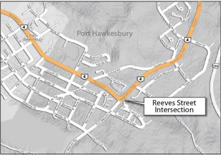
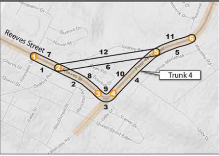
Figure 20 Reeves Street Intersection Figure 21 Reeves Street Network Model
Detailed traffic data was available for this intersection from a traffic study which was carried out in 2000. The demand data, along with the signal timing plans, helped to determine the capacity of the intersection. Thus, the capacities of the various turning movements helped to determine the capacity of each link. Capacities under work zone conditions were estimated by the resident engineer from prior experience with flagging operations. The capacity and demand along the detour route was measured during the peak periods and on weekends by hand.
Application
The local engineers suspected that the reconstruction of the Reeves Street intersection would result in significant queuing and delay and that performing the construction at night could potentially mitigate many of these impacts. Initial results from traffic model proved these suspicions and showed an estimated maximum queue of 4.1 miles resulting in a 70 minute delay occurring on Friday evenings. Queuing and delay were also seen on Monday, Tuesday, Wednesday and Thursday but were approximately half the length and duration as seen on Friday evenings. Detour traffic was estimated at 10,000 vehicles per week. Knowing that the queuing, delay and detour volumes through the residential areas would be contentious issues with residents, the local engineers tested various construction phasing scenarios.
The first scenario had the work zone in place and operating with reduced capacity 24 hours a day, 7 days a week. Queuing during the day on Friday and Saturday were predicted to be especially severe. The engineers noted that queuing and delay did not form during the overnight hours on any day and tested a scenario that eliminated construction during daylight hours on Friday and Saturday (essentially shifting work to night). The results of this scenario cut in half the queuing and delay associated with the construction to 2.19 miles and 36.4 minutes respectively. In addition, the number of weekly vehicles on the detour route was reduced to 6,000, a 40% reduction.
Additional refinements in the work zone design, including tweaking the hours and days of operation, enabled the engineers to better schedule the construction activities so as to not impact motorists. Also, the Nova Scotia Department of Transportation & Public Works did not have a night-time construction policy and did not routinely approve projects for night work due to cost and safety concerns. Because of the results generated by traffic model, the decision was made to carry out some of the most disruptive phases of construction at the Reeves Street intersection at night.
[10] This case study was adapted from the report The Application of QuickZone in Eight Common Construction Projects available from the FHWA Office of Operations.
Table of Contents | Previous | Next