Work Zone Performance Measurement Using Probe Data
2. Guidance for Using Probe Data for Work Zone Mobility Performance Measures
2.1 What is Probe Data?
Probe data is defined as data that is generated by monitoring the position of individual vehicles (i.e., probes) over space and time rather than measuring characteristics of vehicles or groups of vehicles at a specific place and time. Probe data systems can be further characterized according to whether (a) they require additional roadside or vehicular infrastructure to support them or take advantage of existing infrastructure in innovative ways, (b) they produce detailed tracks of vehicle movements or only identify vehicle arrival at select points, and (c) they provide data in near real-time or only with significant delay. Table 2 summarizes different types of probe data collection systems that are currently available.
| Type of Probe Data Collection System | Description |
|---|---|
| Probe Vehicle Runs | This is the original form of probe data measurement in which a vehicle driven by researchers is driven along a route of interest and records the vehicle position and time at either selected positions or time intervals along the route. In terms of the above characteristics, the method (a) requires vehicular infrastructure (the probe vehicle), (b) produces detailed tracks of the vehicles movements along the route, and (c) does not provide data in real-time. |
| Bluetooth Readers | This form of probe data measurement involves placing roadside detectors that identify passing vehicle by a unique identifier broadcast by Bluetooth devices (e.g., cell phones) that are onboard the vehicle. Travel time measurements are obtained by comparing vehicle arrival times at different readers. The method (a) requires roadside infrastructure, (b) does not produce detailed tracks of vehicle movements, and (c) can provide data in near real-time if the Bluetooth readers are equipped with networking capabilities. |
| Toll Tag Readers, License Plate Readers | This form of probe data measurement is similar to the Bluetooth Reader system described above, but identifies vehicles by detecting the unique IDs broadcast by toll tag transponders or using character recognition to determine license plate numbers. Toll tag readers that take advantage of readers at existing toll plazas, rather than additional readers placed specifically for travel time measurement, differ in that they do not require additional roadside infrastructure. |
| Automatic Vehicle Location (AVL) | This form of probe data measurement requires a GPS device in a vehicle that tracks the vehicle's position and periodically transmits information about recent vehicle movements or the vehicle's current location to a server for analysis. This technology is most commonly used for fleet management (e.g., buses, taxis, commercial vehicles). The method (a) does not require deploying infrastructure (assuming the AVL system is already in place), (b) can produce detailed tracks of vehicle movements (but may not, depending on the design of the AVL), and (c) can provide data in near real-time. The GPS technology used also allows measuring the vehicle's speed and direction of travel, in addition to its position. |
| GPS Mobile Devices | This form of probe data measurement is similar to AVL, except occurs on vehicles equipped with GPS mobile devices that are not part of an AVL fleet management system. For example, smart phone applications have been developed that provide probe data from the smart phone. Some onboard navigation systems also include this capability. |
| Cell Phone Tracking | This form of probe data measurement involves tracking vehicle movements based on the radio signal transmitted by cell phones. Each cell phone periodically emits a signal that identifies the phone and associates the phone with a geographic "cell," giving a rough geographic location for the phone. The cell phone system can use data from the signal received at several cell towers to get a more accurate location for the phone. This position information can be retained to generate a track of the phone's (and, by inference, a vehicle's) movement. The method (a) does not require deploying new infrastructure, (b) can produce detailed tracks of vehicle movements, and (c) can provide data in near real-time. |
A probe data system converts these measurements of a vehicle's position and time into performance measures. The most commonly provided performance measure is the average travel time for a pre-defined road segment. The travel time for each vehicle passing over a road segment is estimated by subtracting the time when the vehicle arrives at the end point of the segment to the time when the vehicle left the start point of the segment. The average travel time is computed by processing these vehicle travel times to remove outliers (e.g., long travel times caused when a vehicle diverts from the road segment) and averaging the remaining vehicle travel times.
The work zone delay can be computed from the vehicle travel times by comparing the vehicle travel times when the work zone is present to travel times measured before the work zone was present.
In theory, other performance measures could also be calculated from probe data, but current probe data systems seldom do so. For example, queue length could be estimated by examining vehicle tracks to identify locations where vehicle speeds are low, indicating the vehicle was in a queue. Measuring queue length would require that the probe data system produce a detailed track of the vehicle positions – a Bluetooth system that only identified vehicles as they entered and exited a work zone could not directly measure queue length. The probe data system would also need to have a sufficient number of probes passing through the work zone to accurately identify the entry and exit points of the queue.2 A system capable of measuring queue length would also be capable of measuring queue duration.
Some probe data systems can also produce estimates for vehicle speeds at positions within a work zone. Systems that rely on GPS to measure vehicle position automatically have access to vehicle speed data – this is one of the values provided by GPS. If a probe data system provides a detailed track of position data, then the vehicle speed can be estimated by comparing the position and time of two adjacent position observations. These vehicle speed estimates can be combined to compute the percent the percent of time that work zone traffic is operating at free-flow speeds. Probe data systems are not applicable for estimating some work zone mobility performance measures, such as volume to capacity ratio, volume / throughput, and user complaints.
In practice, probe data vendor companies sometimes combine data from multiple sources, including historical data, to enhance the quality of the data they provide. For example, historical data might be used to fill in gaps when little or no probe data is available. While this increases the overall quality of the traffic data under normal conditions, it can introduce limitations when applied to work zones because the historical data may not be applicable under work zone conditions. The exact algorithms and data sources used by the probe vendor companies to generate traffic data are considered proprietary, so any limitations that may exist when applying the data to work zones is difficult to predict. Some of the case studies described in Section 3 of this report include assessments of the adequacy of probe data sources for work zone performance measures.
2.2 What Work Zone Mobility Performance Measures can be Supported with Probe Data
One factor that impacts the applicability of probe data for work zone performance measures is the size and scope of the work zone and the traffic impacts that are expected to result from it. Four work zone types have been defined based on the expected impact a work zone will have on travelers:[2]
- Type IV. A Type IV work zone is expected to have little or no impact on the traveling public. Examples include activities such as mowing and guardrail repair.
- Type III. A Type III work zone is expected to have a moderate impact on the traveling public. Examples include activities such as shoulder repairs and repaving roadways with moderate traffic.
- Type II. A Type II work zone is expected to impact travelers at the regional and metropolitan levels. Examples include major corridor reconstruction and major bridge repair.
- Type I. A Type I work zone is expected to impact travelers at the metropolitan, regional, or interstate levels over extended periods of time. Examples include the Woodrow Wilson Bridge replacement in the Metropolitan Washington, DC area.
| Probe data technologies are now a viable option for collecting data for work zone performance measures. |
Table 3 represents suitable types of probe data that are appropriate for different types of work zones. Once the work zone affects travelers at a regional level (type I and II work zones), using GPS and cellular based probes that cover the entire region is the best approach. These types of probes can provide network-wide high resolution data. However, when the impact of a work zone is limited to a few segments, portable probes (e.g., Bluetooth sensors) become a viable alternative. In fact, portable probes are more effective during off-peak period and in locations where other types of probe data are limited.
| Probe Data Technology | Type I | Type II | Type III | Type IV |
|---|---|---|---|---|
| GPS Data | ✓ | ✓ | ✓ | ✓ |
| Cellular Data | ✓ | ✓ | ✓ | ✓ |
| Bluetooth Sensors | ★ | ★ | ✓ | ✓ |
| ✓ = Suitable as main data. ★ = Suitable as supplementary data. |
||||
Table 4 presents the most common work zone performance measures and identifies the types of probe data that can be used to calculate each of those performance measures.
| Probe Data Technology | Travel Time | Delay | Queue Length | Speed | Volume | Incidents | Cumulative Impact |
|---|---|---|---|---|---|---|---|
| GPS Data | ✓ | ✓ | ✓ | ✓ | ✓ | ✓ | |
| Cellular Data | ✓ | ✓ | ✓ | ✓ | ✓ | ✓ | |
| Bluetooth Sensors | ✓ | ✓ |
Based on this table, GPS and cellular based probe data provide the means to calculate many different performance measures, while portable probe data (e.g., collected using Bluetooth sensors) have relatively limited capability. However, relying on one type of probe data may not fulfill all of the project needs; and vendors usually supplement probe data with other types of data. In addition, the quality of the data can vary based on location, time of day, and several other factors. Therefore, a combination of data from conventional sensors, portable probe data sensors, and commercial probe data sources is essential to accurately monitor traffic perturbations and travel time variations in the work zone location. For instance, the probe data might not be considered a reliable source during off-peak hours due to the limited availability of probe vehicles; using Bluetooth detectors, conventional loop detectors, and historical data can improve the reliability of the data during these hours. Note that when probe data is not available and other technologies are not applicable, using historical data is the only remaining option.
An important limitation of probe data is that it cannot generally be used to estimate traffic volume, and supplementary data (e.g. loop detector data) is required to calculate this measure. The list below provides more detailed information on the application of probe data to each of the performance measures listed in Table 4.[2]
- Travel Time and Delay are the most straightforward measures to calculate from probe data. Most vendors provide real-time travel time data on a network-wide scale as well as for individual segments. Bluetooth sensors can also provide reliable travel time information between two points in a network. GPS and cellular based probe data can be more cost effective for large work zones as they do not have associated maintenance costs. Note that these measures can be very effective to reflect the effects of type I and II work zones on the regional network.
- Queue Length is another important measure which directly reflects the mobility performance at the work zone location. Once the speed of a probe vehicle drops below a pre-specified value while the next probe vehicle upstream has a reasonable speed, it can be concluded that the probe vehicle is in a queue. This requires data from individual probe vehicles. However, as the probe data does not cover the entire fleet over a segment, the queue length calculated based on this data is an estimation of the queue length. The accuracy of this estimation improves as the percentage of probe vehicles increases in the segment. The accuracy of the estimation also depends on the length of the segment for which the speed is provided. Most probe data from commercial vendors currently provide travel time information for Traffic Message Channel (TMC) code segments (see Section 2.4), which can be very long in rural areas and, therefore, queue length estimation can be inaccurate. It is expected that growing number of probe sources will soon allow customers to define their own segments and consequently, GPS and cellular based probes can be used to estimate queue length more accurately. The location of queue relative to the work zone location is also an important factor to consider. This measure can be used to investigate the impact of a work zone on the traffic upstream. In addition, the duration of queue can be determined based on the probe data which reflects another impact of work zone on travelers.
- Speed is an important mobility measure which is directly provided by the probe data vendors. Similar to travel time and delay, the average speed over a region can be calculated more accurately using GPS and cellular based probes. Bluetooth detectors can also provide average speed between two points in a network. When accurate disaggregate speed at a certain location is required, non-probe-based data collection may be required.
- Volume is a performance measure that reflects the amount of traffic exposed to any negative impacts of the work zone. Because probe data systems only provide data for a sample of vehicles, no current probe data system provides volume data. If volume data is required, other data collection methods may be required.
- Number of Incidents in the work zone location is a work zone safety performance measure which also affects other mobility measures described in this report. An incident can be inferred using probe data from the irregular traffic patterns it creates. However, the exact source of the irregular traffic pattern cannot be detected using probe data; therefore, other data sources (e.g. CCTV cameras, police reports, etc.) should be incorporated in the analysis. Note that this measure is not often used in real-time and should instead be used as a long term safety measure. The short term impact of an incident on mobility measures is, however, still important.
- Cumulative Impact refers to evaluating the impact of multiple work zone projects within a region or a corridor. The impact of multiple projects on the traffic pattern can significantly exceed the impact of individual work zones. GPS and cellular based probe data, because they provide data network-wide, can be used to investigate the cumulative impact of several work zone projects on the regions' mobility. Note that the percent of work zones meeting expectations for traffic flow can be also evaluated using this measure.
2.3 How is Probe Data Collected, and by Whom?
There are two primary ways in which work zone probe data is collected: (1) by agencies or agency contractors collecting probe data to support work zone traffic management or performance measures for a specific work zone and (2) by third party companies collecting probe data to produce commercial traffic data products. The first type of work zone data collection is similar to traditional work zone traffic monitoring and does not require much additional explanation. The remainder of this section focuses on the second type and provides summary information on the largest vendors of mobile traffic data currently active in the United States that claim to have traffic data on a national scale: Inrix; TomTom; AirSage and NAVTEQ (a subsidiary of Nokia). Table 2 presents the overview and characteristics of the probe data provided by these vendors. Despite considerable progress, many parts of this market are still at an early stage of development. This means that certain key variables (price, for example) are not standard and vary based on market conditions. To date, most mobile data firms have focused on traffic information that supports navigation systems or 511 systems and do not have produces specifically tailored for work zone performance measures.
Vendors acquire the raw data from several data sources. These data sources include GPS data from fleet management companies that track individual vehicles (fleet can include trucks, light commercial vehicles, and taxis), navigation data from private vehicles, cell phone applications, cell phone locations, fixed sensors (operated and maintained by the data provider, other providers, or other agencies), and commercial devices [1].
The acquired raw data is then aggregated and anonymized. However, the level of aggregation varies among different vendors, with typical aggregation levels ranging from 15 to 60 minutes [1]. In fact, a vendor should consider the availability and aggregation level of different data sources in selecting the aggregation interval. In addition to the network wide aggregate data, most of the vendors provide individual data points for a selected segment and a time period. Network wide historical data is also provided by all vendors [1].
| Mobile Traffic Data Sources | Technology Used | Traffic Data Elements Collected | O-D / Trajectory Data and Point Data Availability | Real Time and Historical Data Availability | Location-Codes Used | Other information |
|---|---|---|---|---|---|---|
| Inrix | Commercial GPS data, DOT sensor data, and other proprietary data sources. GPS-enabled vehicles | Speed |
Point | R, H | TMC Codes | Data available for TMC road functional classes FC1, FC2, FC3, and some FC4; Flexibility in data format / levels of aggregation for up to latest 90 days |
| TomTom | TomTom devices (GPS) |
Speed Travel Time |
Point, Trajectory Origin-Destination |
R, H | TMC Codes, Proprietary Segment Tables | |
| NAVTEQ | State of the art probe data processing including both point and route-based observations (Cellular) Data from NAVTEQ's proprietary sensor network | Speed Travel Time Volume from own sensors |
Point | R, H | TMC Codes, Proprietary Segment Tables | |
| AirSage | Wireless signaling data, Cell phone GPS, Other Carrier Data | Date and timestamp, Mode, Speed, Travel Time, Location ID, Alert | Point Origin-Destination |
R, H | TMC Codes | Data available for TMC FC1-FC4; O-D data available in blocks as small as 1,000 sq.m. [fast becoming their most popular product, latest application an O-D study for LA-Las Vegas hi speed rail]; |
| TrafficCast | Information derived from GPS tracking data, public sensors and reports of accidents, road works and weather reports. Bluetooth Travel-time Origination and Destination devices. |
Speed Travel Time |
Point, Limited trajectory data depending on Bluetooth deployment configuration Origin-Destination |
R, H | TMC Codes |
2.4 Are There Specific Probe Data Technical Issues to Consider?
Although using probe data provides certain advantages over conventional data collection methods, the current practice in providing probe data faces certain challenges and limitations. The presentation of probe data on a geographical map is a challenge for vendors and users of this data. Basically, probe data is aggregated and provided based on a Traffic Message Channel (TMC) location referencing system. TMC segments are defined and managed by Nokia and TomTom. These segments vary in length based on the density of the roadway network. This criterion creates short segments in urban areas (the length of a block) and very long segments in rural areas (the distance between two interchanges). Therefore, information on a work zone segment shorter than the entire TMC segment can be distorted.
Some probe data vendors provide more detail within TMC codes which helps to differentiate whether delays are closer to one end of the TMC segment or the other. Note that another referencing system is Open Location Reference (OLR) which does not assign the location to TMC segments, and therefore offers more flexibility in presenting speed information. The selected segment in this system can align with the physical location of the work zone.
The aggregation time interval of probe data also presents another challenge to work zone management. Work zone management and operation control require real time data with short aggregation time intervals to monitor queue formation and propagation, current travel time, and incident occurrence. Short aggregation time interval data also provides more reliable base data for predicting traffic evolutions over time and space. However, a shorter aggregation time means a smaller sample size for the aggregated estimates, which means less accurate estimates.
To date, most vendors use 15 or 60 minutes aggregation time interval which smooth out minor fluctuation is traffic flow, speed and density as well as travel time. This time interval can be too long to identify quickly changing characteristics like can be associated with work zones. The simulation results in Appendix B show a queue expanding from 0 to 200 feet in 5 minutes time, then dissipating in the succeeding 10 minutes. Even a 15-minute aggregation period would miss key characteristics of this type of work zone queue formation. The Maryland State Highway Administration project (see Section 3.1) also identified data lag (e.g. the difference between the time of actual speed perturbations in the field and the time that the perturbation is reported in the data) as a challenge in using probe data.
Probe data is expected to represent the overall traffic in a segment. Therefore, the percent of vehicles acting as probe vehicles becomes an important challenge to incorporate probe data into work zone management and operation. Sample size varies based on the technology (GPS, cellular, Bluetooth, etc.) used by the firm that provides the data, time of day, and location. Thus the volume of data provided by the probes may not be adequate to represent the entire fleet at a segment especially during off-peak hours and in arterials. Note that the volume of probe data is increasing rapidly so the extent and nature of these problems should improve over time.
2.5 When is the Use of Probe Data Worth Considering?
Work zone management includes timely decision making to reduce the impact of the work zone on travelers. This task requires accurate information about the current status of the traffic in the work zone vicinity. Probe data can provide this information on a real time basis. However, several factors should be considered when selecting probe data as the source of information.
| Factors that favor the use of probe data from commercial vendors include the need for programmatic performance measures, availability of data acquired for other reasons, and the need for detailed data over a broad area or a long period of time. |
- Performance measure objectives
As already noted, there are many distinctions between the requirements for supporting programmatic performance measures to assess the mobility performance of a work zone program and project-specific performance measures for real-time monitoring of work zone mobility. For the former, third part probe data vendors provide perhaps the only cost-effective approach for mobility data that will uniformly apply to most work zones. For the second, many more options are available.
- Availability of probe data
Two of the case study projects described in Section 3 of this report took advantage of real-time probe data that was purchased for other reasons to support work zone performance measurement activities. In Maryland (see Section 3.1), a real-time performance measure dashboard was developed that computed and displayed mobility performance measures for active work zones. In Virginia, archives of probe data was used to compute travel time reliability measures for 15 work zones. Another example comes from the Utah Department of Transportation, which recently purchased access to historical probe data in order to assess the potential to use the data for a variety of purposes, including improving traffic signal timing plans and computing performance measures. When probe data has already been purchased to support other DOT objectives (e.g., to provide traveler information), it can greatly decrease the cost of establishing performance measure programs for work zones.
Note that licensing restrictions apply to most probe data obtained from probe data vendors. These restrictions may limit the application of the data or its distribution. Before re-using probe data obtained for another purpose, the licensing restrictions under which the probe data was obtained must be considered.
- Nature of the task
The nature of the task determines the data required. If the task requires detailed information on traffic evolutions in real time, the use of probe data is inevitable. For instance, real time monitoring of a work zone, real time management of traffic conditions in a work zone location, and responding to public in real time (providing travel time, delay, and speed to public) require accurate information on the traffic evolutions along that work zone segment. On the other hand, when all the necessary information can be obtained from conventional sensors and/or historical data, the cost of acquiring the probe data is a preventing factor. For instance, monitoring spot speed along a work zone at a defined location can be obtained from conventional sensors.
- Duration of the work zone
Considering the cost of acquiring the probe data, monitoring work zones that affect travelers for a very short period may not be cost effective. In addition, based on the duration of the work zone, different types of probe data might be suitable. Longer durations require more robust technologies with minimal maintenance effort. Therefore, GPS based and cellular based probe data is more appropriate for longer durations and using Bluetooth detectors is more appropriate for shorter durations. This factor is less important when probe data has already been purchased to support other DOT activities.
- Scale of work zone impacts on traffic disruptions and local surroundings
The scale of work zone impacts also is an important decision factor in selecting the most appropriate type of probe data. The potential for large traffic disturbances justifies close monitoring of the traffic performance in the impacted area, which may require the use of GPS and/or cellular based probe data. On the other hand, when a work zone is expected to have minimal impact on traffic, monitoring the area using probe vehicle data may not be justified, considering the cost of acquiring that data.
The existence of multiple work zones along a corridor or nearby routes can also justify the use of probe data. The cumulative effect of multiple work zones on a network can be significant and demands close monitoring of traffic disturbances.
The scale of the likely impacts also affects the most suitable technology for collecting probe vehicle data. Monitoring a long corridor or a network using a system that requires point-based roadside infrastructure (e.g., Bluetooth) can be expensive because of the large number of detectors required. In those cases, an approach that does not rely on roadside infrastructure (e.g., GPS, cellular based probe data) may be more suitable. - Lack of conventional sensors
In locations with existing conventional sensors, the existing sensors may provide sufficient data about the work zone to satisfy work zone performance measure needs. When existing sensors are not available, probe-based methods can be a cost-effective alternative.
- Availability of specialized software to compute performance measures
One of the objectives of the Maryland State Highway Administration project described in Section 3.1 was to develop work zone performance measurement software that was applicable to any location with access to real-time traffic monitoring data at work zones. Access to specialized software such as this can reduce the cost of establishing a work zone performance measurement program.
2.6 What Needs to be Done Before Using Probe Data for Work Zone Performance Measures?
Incorporating probe data into the work zone management and operation requires certain considerations. First is the need to obtain performance measures for the work zone, which will primarily depend on work zone policies and procedures. The question of whether performance measures are needed is outside the scope of this document, so the remainder of this section assumes that it has been determined that performance measures are needed for the work zone being considered.
The next question to consider is whether to use traditional traffic detection, infrastructure-based probe data detection (e.g., Bluetooth detectors), or probe data from a third party vendor. The previous section identified factors that should be considered when determining whether to use probe data and what type of probe data to use. The use of infrastructure-based probe data detection shares many characteristics with the traditional traffic detection with which work zone managers are already familiar. The application of probe data from third party vendors, however, offers some unique challenges. Figure 2 depicts a decision chart that can help determine when probe data from a third party vendor is a viable alternative to support work zone performance measures.
Figure 2. Decision Chart for Acquiring Probe Data from a Third Party Vendor
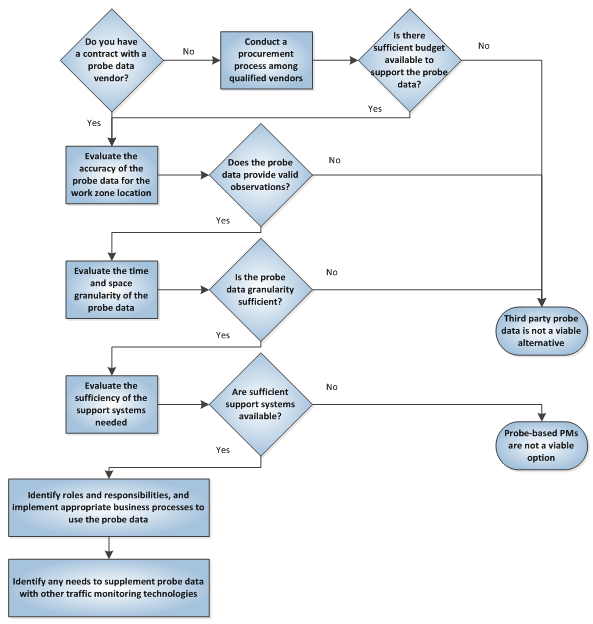
The first question is whether a contract exists for probe data and the probe data can be re-used for the work zone. If not, one must evaluate the cost of obtaining probe data. If data is available, the licensing agreement under which the probe data was obtained must be reviewed to verify that it can be used to support the work zone performance measures.
Next, the accuracy of the probe data at the work zone location should be evaluated. Note that the accuracy of the probe data can depend on the work zone location and the source of the probe data. For example, GPS-based probe data may rely on GPS data from commercial vehicles, so will be more accurate for work zone locations with more commercial vehicle traffic. The accuracy of most probe data systems will also vary by time of day because changes in traffic volumes over time result in different numbers of probe observations at different times of day. One might need to also consider work zone traffic management processes that will be put in place. For example, routing of commercial vehicle traffic around a work zone may significantly reduce the number of probe observations available. The extent to which historical data is used by the third party vendor in their travel time estimation process should be considered. Lessons learned during Virginia DOTs use of probe data for work zone performance measures (see Section 3.2) indicated that full road closures could result in an inaccurate picture of a work zone area. When no real-time data was available, historical observations were used that did not always agree with actual traffic conditions.
The time and space granularity of the available probe data must also be considered. If the segment size for which probe-based travel time data is available is too large or the time interval between travel time updates is too coarse, the third party probe data may not suffice to meet the performance measure needs. If all of the above constraints are met, then third-party probe data is a viable alternative for the work zone performance measures. But, there are additional steps that must be taken before third party probe data can be applied to the work zone.
The support systems – the computer hardware, software, and communication systems needed to receive, process, analyze, and broadcast information to intended users – must be sufficient. The business processes must be put in place to make use of the probe data, and the roles and responsibilities of those responsible for implementing those processes must be defined. Lastly, any needs to supplement the probe data (based on deficiencies identified in the previous evaluation steps) should be considered.
2.7 What Needs to be Done Before Using Probe Data for Programmatic Performance Measures?
As already noted, the decision for whether to apply probe data for programmatic performance measures is different than the decision for an individual work zone. Probe data from third party vendors, in particular, provides the potential to apply a uniform set of performance measure produced from a uniform set of data across most or all work zones in a State. This is a capability that is difficult to meet with other data sources.
| Probe data from commercial vendors is particularly well-suited for computing a uniform set of performance measures across many different work zones. |
Most of the considerations described in the previous section also apply when evaluating the potential for using probe data for programmatic performance measures. For example, if probe data is already available because of an existing contract with a third party probe data provider, then the cost of establishing programmatic performance based on probe data will be greatly reduced. When identifying whether sufficient support systems are available, the results of the Maryland State Highway Administration project described in Section 3.1 should be considered. This project created a work zone performance measure system that has the potential to be re-used in other States.
2.8 Design Considerations
The impact of work zones on traffic operations varies based on several factors including scale of activity in the work zone, road type, flow level, time of day, time of week, weather condition, and occurrence of special events or evacuation. Work zone traffic impacts can stretch far upstream of the work zone and even impact nearby roadways. Therefore, predicting and monitoring the impact of work zone on the traffic patterns and travel behavior are essential before and during the work zone operation. Probe data can provide the required accuracy and detail to monitor the traffic evolutions in real time along a corridor. However, as mentioned previously, probe data faces certain limitations including TMC based aggregation and long aggregation time interval. TMC segments may have start and/or end points that do not align with work zone limits. In addition, the long aggregation time interval may smooth out the short term fluctuations and disturbances. The limited availability of probe data at certain times and certain locations is another limiting factor and agencies may consider supplementary data (e.g. portable probes and historical data) for these times and locations.
| Tools and techniques for using probe data to compute work zone performance measures are still evolving. |
Work zone management and operation requires an automatic and robust system to collect, analyze, and archive performance data (and raw data if necessary) during the operation. The system should be able to later retrieve the required information based on specific agency needs. This task requires coordination between the agencies, their contractors, equipment suppliers, and other third party agencies. It also requires specific training, and agencies should consider all the required means in advance. Considering a central location with trained personnel specifically for this task may reduce the cost of collecting, analyzing, and archiving probe data over time.
Special considerations apply for systems that generate alerts when pre-determined conditions occur (e.g., work zone travel time exceeds a threshold value). Standardizing these alert notifications and the corresponding thresholds based on certain parameters (including scale of activity, type of road, location of the road, flow level, time of day, day of week, weather condition, and occurrence of special event or evacuation) is essential and provides the necessary means to compare the performance over multiple work zones. This is especially important when reporting alerts to the general public – in that case, it is necessary to provide consistent information. Therefore, a certain set of alerts should be determined to report to the general public regardless of work zone characteristics, location, and time of day. Alerts can vary based on the project objectives and other parameters.
In addition, alerts and corresponding thresholds should be customizable to a certain level based on the project needs and characteristics. For instance, a low maximum speed alert might be appropriate when workers are present at the work zone location, but unnecessary when workers are not present. It is also important to note that there should be a guideline for adjusting the thresholds to eliminate any misleading information. The Maryland SHA case study in Section 3.1 includes examples of a flexible system for managing alerts.
2.9 Institutional Considerations
In addition to the design considerations, incorporating the probe data into work zone management and operation can affect traditional institutional agreements.
Conventional data is typically owned and managed by the governmental agency, which is not the case for probe data from a third party vendor. Instead, probe data from a third party vendor is provided with a "limited rights" license which limits the extent to which the governmental agency can distribute and share the data. Therefore, using probe data requires new client and contractor roles and responsibilities. The contractors' access to probe data (or at least the performance measures) should be granted in the contract with the probe data vendor and other contractors.
In addition, analyzing probe data in order to extract different performance measures requires certain expertise. The level of training depends on the agency's needs, and the necessary training should be performed before the start of the project. The contractors should also have a minimum level of training to utilize the probe data in their assigned tasks and to facilitate communication with governmental agencies and the probe data vendor.
Any work zone project that significantly affects the public will benefit from providing them with information. Offering accurate information to the public can help them adjust their travel behavior to avoid delays resulting from the work zone activity. Consequently, the governmental agency identifies the potential impact throughout the project duration and can implement effective strategies to mitigate the impacts [2]. .In this regard, probe data can provide an excellent basis for providing real-time work zone traffic information to the public. However, this requires coordination with the probe data vendor to solve licensing issues, as well as some IT contractors which are responsible to create the user interface.
2.10 Reporting Considerations
In addition to improvements in work zone management and operation, availability of probe data enhances the quality of project reports. More accurate evaluation of work zone performance measures can be presented. However, standards are needed to enable consistent and meaningful comparison between different types of work zones. While providing more detailed information regarding the work zone operation, the analysis should be consistent with the reports that only use conventional data collection methods.
2 Section 3.1 describes an alternate approach for estimating queue length based on travel time observations. [ Return to note 2. ]