5.0 Work Zone Impacts Assessment During Preliminary Engineering
5.1 What Happens During Preliminary Engineering?
Preliminary engineering is the first stage in project development. This is the stage when designers and project planners conduct early project-level planning and develop an overall design concept of what the new facility would look like. At this stage, projects that are identified in systems planning are handed over to the respective project planners and designers to further develop the project. The main objective is to identify ways to implement the project, and develop appropriate plans and design concepts. Therefore, during preliminary engineering more project-specific information is collected and synthesized.
The key difference between systems planning and preliminary engineering is that, in systems planning transportation improvement needs are identified, potential alternative solutions are developed and evaluated, and the best alternatives are chosen for further development and implementation. Therefore, the focus of systems planning is to identify projects. In preliminary engineering, planning is done at the project-level to identify and develop ways to implement the solution, identify potential issues/obstacles, and develop an implementation concept for the project. The focus of preliminary engineering is to identify ways to implement projects.
Preliminary engineering is also referred to as the first stage of design. Project design is an iterative process with several design stages. Some States refer to these stages as the 30% (preliminary engineering), 60%, 90%, and final design stages. Preliminary engineering and the subsequent design stages are generally performed by similar staff, i.e., project planners and designers belonging to the design/engineering departments of transportation agencies, either at the central office or the region/district level. Their primary responsibility is to plan, develop, and design specific projects. Often preliminary engineering and design take place in tandem without a clear-cut distinction between the stages. This document however discusses work zone impacts assessment for preliminary engineering and design in separate chapters. This was done to emphasize the importance and potential benefits of specifically advancing work zone considerations to the preliminary engineering stage, and to highlight some of the early work zone impacts assessment activities that may be performed during preliminary engineering. Such advancement of work zone considerations could make project development and work zone impacts assessments more systematic. The discussion of work zone impacts assessment separately for preliminary engineering and design is not intended to imply that decision-making by transportation agencies is highly compartmentalized.
Major preliminary engineering activities include:
- Conducting early project-level planning activities (e.g., collecting data, reassessing the project purpose and definition, conducting site visits and site investigations).
- Further defining project needs (e.g., identifying the type of pavement, identifying the required thickness for the overlay).
- Identifying build options for the project (e.g., rebuild on existing right-of-way (ROW), realign roadway, use of multiple contracts vs. a single contract).
- Identifying other impacts and coordination issues (e.g., environmental, utility, ROW).
- Identifying potential construction and traffic control approach(es) (e.g., reduced width construction, night work, cross-over construction, weekend closures).
- Developing preliminary design concept(s) based on the above activities; and
- Developing a preliminary cost estimate for the project.
For some projects preliminary engineering activities may overlap with systems planning and/or design (e.g., large regionally significant projects that require multi-year planning, preliminary engineering and design studies).
5.2 Objectives of Work Zone Impacts Assessment During Preliminary Engineering
The bulk of work zone impacts assessment has typically taken place during the later design stages of project development. This can be a problem if work zone issues identified during the later design stages lead to changes in overall project approach. Often times, designers and construction staff express frustration when they encounter issues that could delay project development and/or implementation. For example during design if it is identified that an alternate route chosen for a particular project will also be under construction at the same time, the entire transportation management approach for the project may have to be changed, potentially resulting in project delays and increased costs. If such issues are identified just prior to, or during construction, it could be even more problematic because construction may have to be stopped on the project. As a result, sometimes in order to keep the project moving, decisions may be made that may not best address the work zone safety and mobility needs of the project.
In light of the above, agencies are increasingly trying to address and at least identify more of the work zone impacts issues during preliminary engineering.
The Washington State Department of Transportation (WSDOT) develops a Work Zone Traffic Control Strategy early in project development during a required project design conference attended by traffic engineers, law enforcement officials, and construction engineers. The strategy addresses issues such as the number of lanes that can be closed, hours of the day and days of the week when work can occur, level of service (LOS) to be provided during construction, and the need for night operations. The development of such an overall work zone strategy early in project development ensures that the identified issues are considered in design, and later in developing the traffic control plan (TCP). A checklist has been developed to alert people to the various strategies available. This approach also helps earmark funds early in project design to cover the cost of providing adequate safety and mobility.
Source: FHWA Work Zone Best Practices Guidebook, April 2000, http://ops.fhwa.dot.gov/wz/practices/best/Default.htm (Accessed 01/05/06).
The key to work zone impacts assessment during preliminary engineering lies in advancing work zone considerations as early as possible in project development; identifying the potential work zone impacts of the project early enough so that work zone related project delays or costs are not incurred in later design stages; and identifying and developing work zone management strategies in a more streamlined manner.
The following are the objectives of work zone impacts assessment during preliminary engineering:
- Using the preliminary engineering development information (e.g., concept plans, preliminary designs, location and design documents, environmental/NEPA assessments) to further incorporate work zone impacts considerations in choosing build options for the project and identifying potential construction staging approach(es).
- Reassessment/identification of the potential work zone impacts of the project.
- Reassessment/confirmation of significant project[1] designations.
- Reassessment/identification of potential work zone management strategies.
- Further identification of coordination issues with other projects, and other coordination issues (e.g., utilities, enforcement, environmental, ROW, community impacts).
- Reassessment/estimation of the cost of the identified work zone management strategies, and development of high-level implementation plans for the strategies.
Assessing work zone impacts during preliminary engineering may answer questions such as:
- Is the project definition any different than what was identified during systems planning and are there additional work zone impacts issues that need to be addressed?
- Given the concept design for the project, what are the possible construction staging and traffic control approaches that I can use for the project?
- What are the work zone impacts implications of the potential construction staging and traffic control approaches?
- Given that the project strategy has changed from what was originally assumed during systems planning (e.g., decision is made to build the project at night), are the work zone impacts any different now, and are there additional issues that I should address?
- Based on the concept design and potential construction and work zone traffic control strategies, is the originally assumed designation of significant project still valid for my project, and should I re-examine the work zone management strategies that were identified during systems planning?
- Are there any other concurrent projects nearby that were not identified during systems planning and may have an impact on my project or vice-versa (e.g., based on an updated version of the transportation plan/program for the region)?
- Based on site visits, are there any other coordination issues such as utilities, environmental, ROW, and community?
5.3 Who Are the Participants?
The staff that may perform the work zone impacts assessment during preliminary engineering, the inputs and input providers, and the outputs and users of the outputs are shown in Table 5.1.
Preliminary engineering assessments are generally performed by the project design and construction team. This includes:
|
|
| Inputs | Input Providers |
|---|---|
|
|
| Outputs | Users of the Outputs |
The output is the preliminary work zone strategy, which consists of:
|
The users of the output constitute the project design and construction team, including:
|
5.4 Assessment Process
Figure 5.1 illustrates the steps involved in work zone impacts assessment during preliminary engineering. Some notes pertaining to the figure are presented in Table 5.2.
Figure 5.1 Preliminary Engineering – Work Zone Impacts Assessment Process
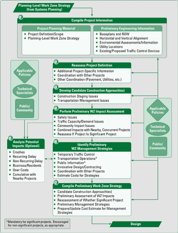
| At a glance, the preliminary engineering process diagram (Figure 5.1) may resemble the systems planning process diagram (Figure 4.2). Though the process steps, the types of issues, and the outputs of the assessment may seem similar, the key difference is the extent to which those issues are addressed. More project-specific information becomes available in preliminary engineering, and the work zone impacts assessment needs to reflect that. For example, preliminary engineering site visits and surveys may indicate the need for utility relocation prior to construction. The time needed for the utility relocation could extend the project schedule into a heavy travel weekend (e.g., holiday weekend). As a result, the project strategy may have to be revised to either adjust the schedule to avoid the holiday weekend, or include appropriate traffic management strategies to accommodate holiday traffic during that weekend. |
Input from and interaction with appropriate sources (as shown in Figure 5.1) may be required during the assessment as follows:
|
| The interface between preliminary engineering, systems planning, and design may be fluid. Decision-making and activities from one phase may overlap with or extend into the other. Further for some projects, systems planning, preliminary engineering, and/or design activities may be conducted as part of the same study (e.g., large regionally significant projects that require multi-year studies). |
| Agencies may combine work zone impacts assessment with environmental/NEPA assessments. Generally, agencies prepare three types of environmental reviews under NEPA: Categorical Exclusions (CE) for small, routine projects with insignificant environmental impacts; Environmental Assessments (EA) for projects with no significant environmental impacts; and Environmental Impact Statements (EIS) for projects with significant environmental impacts. The opportunity exists to combine work zone impacts assessment with the environmental/NEPA assessments. Sometimes the NEPA process can be a primary source of work zone related constraints or inputs for the project. Example of issues that may be addressed include how work zone impacts tie into the project location and design process and how work zone impacts are weighed against other socio-economic/environmental impacts and other project considerations. More information on NEPA is available at http://www.environment.fhwa.dot.gov/projdev/index.asp (Accessed 12/22/05) |
| Preliminary engineering work zone impacts assessment may result in more than one preliminary work zone strategy, in which case multiple options may be carried over to the design stage for further investigation and analysis. |
The following sections provide a brief explanation of the process.
Step 1 of 7: Compile Project Information
Compilation of available project information includes:
- Project planning material from the systems planning phase. This material includes the project definition and scope and the systems planning level work zone strategy. In essence, the systems planning-level work zone strategy will now be refined based on more project-specific information to develop the "Preliminary Work Zone Strategy." This preliminary work zone strategy will have more project-specific detail and will serve as a foundation for the subsequent design stage. If the planning level work zone strategy is not available, information on the project definition/scope, roadway/traffic characteristics, and other contributing factors (public/community issues, weather considerations, special events, etc.) should be compiled as described in Step 1 of the Systems Planning process.
- Preliminary engineering development information. This is the concept design for the project, and consists of preliminary decisions on roadway alignment and ROW, cross-sectional details, elevation and super-structure details, and other information necessary to initially depict what the new facility will look like after it is built. In the case of preservation projects, the new facility may not be very different from the current facility. For rehabilitation, reconfiguration, and new projects, the vision of the new facility may be drastically different from the present state. The information that is collected in this stage is essential to be able to perform work zone impacts assessment in later steps and at later stages. The following are some examples of information that need to be collected and/or developed:
- Engineering plans, documents, and supporting information that define the project environment in detail.
- Information from available or ongoing studies and environmental/NEPA assessments (e.g., project constraints, impact mitigation requirements, recommended assessments and/or analyses).
- Topographical, soil, and hydraulics information.
- Existing and future roadway and traffic characteristics.
- Base plans showing existing and planned roadway alignment, existing and planned ROW, existing and proposed traffic control devices (e.g., signs, signals, pavement markings), and existing and proposed overhead/underground utilities.
- Information on other nearby transportation facilities and/or junctions (e.g., adjacent routes, highway interchanges/intersections, railroad crossings, rail stations, bus stops).
- Coordination issues with other ongoing or planned projects.
- Any other relevant information specific to the project location (weather, special events, etc.).
TIP: This step is a good checkpoint to reassess/identify if there are any policy provisions that apply to the project. For example, the agency may provide policy guidance on the different work zone impacts issues that need to be addressed during preliminary engineering.
The Texas Department of Transportation (TxDOT) provides guidelines on data collection/preliminary design in its Project Development Process Manual. Guidance is provided on obtaining the data necessary for making engineering and environmental decisions related to project design. TxDOT recommends that data collection be as complete as possible so that project solutions that provide the most benefit are selected. The activities that comprise data collection/preliminary design include: early coordination with stakeholders; preparation and execution of additional agreements; review of traffic data; obtaining right of entry; obtaining related data, plans, studies, and reports; conduct of a site visit; obtaining information on existing utilities; obtaining traffic accident data; obtaining hydraulic studies; obtaining aerial photography/planimetrics/digital terrain maps (DTMs)/digital orthophotography; and conduct of topographic and other surveys.
Source: TxDOT Project Development Process Manual, August 1, 2003. URL: http://manuals.dot.state.tx.us/dynaweb/coldesig/pdp/@Generic__BookView (Accessed 01/05/06).
Step 2 of 7: Reassess Project Definition
This step involves performing a reality check as to whether the previously developed project definition (during systems planning) still holds true, given that there is more detail available on the project. Additional data may be collected in this phase in order to provide a more complete set of information with which to complete the assessment and evaluation of project and work zone issues. Examples of the types of additional data that may be required to reassess the project definition are:
- Additional traffic counts.
- Information from other projects and studies.
- Information related to project specific issues and concerns, such as:
- Pedestrian counts in residential areas.
- School bus schedules.
- Existing incident response times from accidents in the project area.
- Coordination issues with other projects (within the impactable vicinity).
All data elements may not be required for all projects. The required data elements and the level of effort will depend on agency policy/procedures and on the type, duration, complexity, and expected work zone impacts of the project.
The following are examples of issues that may be considered in reassessing the project definition:
- Project purpose, location, extent, duration, nature of work, and type of work zone.
- Roadway alignment and ROW issues.
- Cross-sectional details, elevation and super-structure details.
- Related pavement and structural needs.
- Soil, hydraulics, and environmental needs.
- Utility related infrastructure and coordination issues.
- Design parameters.
Step 3 of 7: Develop Candidate Construction Approaches
This is where a preliminary decision as to how the project will be built is made and an overall strategy for the construction (e.g., phased construction, design-build) and the work zone type (e.g., night work, lane-closure, cross-over, full-closure) is developed. Until this step, most of the effort involved collecting systems planning level information, collecting preliminary design information, and verifying and re-examining prior assumptions. Given the information available at this juncture, the designer may now consider and develop candidate construction approach(es). The planning-level construction staging and traffic control approaches are revisited and potentially modified, and other alternatives are developed. Transportation management issues related to the project and candidate construction, staging, and traffic control approaches are also identified.
The types of issues to be considered in developing the candidate construction approaches are discussed in Step 2 of the systems planning process description in Section 4.5.
More information on different construction/traffic control approach(es) is available in Developing and Implementing Transportation Management Plans for Work Zones, available at http://www.ops.fhwa.dot.gov/wz/resources/final_rule.htm (Accessed 1/18/06).
TIP: Construction personnel and/or contractor representatives (if allowable) can provide valuable input towards identifying the potential construction/traffic control approach(es) for a project.
Step 4 of 7: Perform Preliminary Work Zone Impacts Assessment
Preliminary engineering is accomplished by conducting field investigations, surveys, and public/community outreach using the principles of highway and traffic engineering. This is also the phase where potential ROW acquisition issues; environmental impact/NEPA issues, including impact of the new facility and the construction project on the environment; and community impact issues, including impact of the new facility and the construction project on the community, are addressed. Therefore, this is a very suitable time to incorporate work zone impacts issues into the investigations and assessments that are already being performed. The information obtained from the assessments can help the agency take further action, such as establish the requisite teams, involve appropriate personnel, contact stakeholders, and take necessary actions to facilitate the availability and use of transportation management strategies for construction. For example, if it is determined that a work zone traffic incident management system/strategy will be necessary for the construction project, the agency may delegate that to their traffic operations staff who may begin assessing the traffic incident management needs for the project, in conjunction with the project design/construction team, and other appropriate stakeholders.
This step is expected to be a qualitative assessment involving a quick identification of work zone impacts issues, re-confirmation whether a project is a significant project (discussed in Table 1.1 and in Section 4.5 under Step 2 of 6), identification of potential work zone management strategies, and determination of whether more detailed (quantitative) work zone impacts analysis is needed. The assessment will be based on the candidate construction staging, traffic control approaches, and transportation management issues identified in Step 3, and will help flush out and identify potential concerns prior to the completion of partial design (e.g., 30% design plans). In later stages of design, designers may use the work zone issues and impacts identified in this step to "design their way out of" any potential problems or obstacles.
It is important at this stage to re-confirm whether a project is significant because more detailed project specific information is now available, which may change previous assertions/assumptions. For example, during preliminary engineering the project approach may be modified to construct the project at night as opposed to the planning level assumption of constructing the project during the day. As a result, the work zone impacts of the project may be lower than what was anticipated in the systems planning assessment, resulting in a re-classification of the project to a non-significant project. Conversely, an assumption may have been made during systems planning that designated a project as non-significant. Additional preliminary engineering data during this step may void that assumption, leading to a re-classification of the project as significant.
The activities that need to be performed in this step are similar to those of Step 2 of the systems planning process, where a screening-level work zone impacts assessment of alternatives is performed. The key difference between the systems planning and the preliminary engineering assessments is that in preliminary engineering the objective is to develop the best way to plan, design, and build a given project; whereas in systems planning, the objective is to identify alternatives that best meet a given need and have the least impacts from an environmental, work zone, and societal perspective. Extensive and well thought-out preliminary engineering and investigation leads to a better understanding of the project needs and potential impacts, and eventually leads to a better project design. The following are some examples of issues to consider. Refer to Step 2 of systems planning for more information.
- Is the project definition any different than what was identified during systems planning?
- If the project strategy has changed from what was originally assumed during systems planning (e.g., decision is made to build the project at night), are the work zone impacts any different now, and are there additional issues that I should address? Does the potential impact area (discussed in Step 2 of systems planning) of the project need to be reassessed or identified?
- Do ongoing (or completed) environmental/NEPA or other studies provide any constraints and information that may limit project location, design, and construction options?
- What are the safety implications (e.g., lane width issues, lane/shoulder closure issues, line-of-sight issues, horizontal and vertical curvature, ramp-closure issues) of the potential construction approaches?
- What are the traffic/mobility implications of the potential construction approaches? (e.g., lane closure restrictions, potential choke points, whether delays are expected, need for detour routes, potential impact on detour routes, potential impact on other transportation infrastructure such as railroad crossings and interchanges).
- Identify and list out major impacts (safety and mobility) of the project and possible mitigation strategies, including project/work zone design options, contracting strategies, and other mitigation measures.
- Based on the concept design and potential construction and work zone strategies, is the originally assumed designation of significant project still valid for my project?
- Based on site visits, are there any other coordination issues such as utilities, environmental, ROW, and community?
- Are there any obvious issues that can be addressed right away and noted down so that they need not be addressed in later design stages (e.g., history of high weekend traffic volumes at the project location due to tourist traffic as a result of which weekend lane closures may not be a good option)?
- The level of work zone impacts assessment needed for the project: Is a high-level (qualitative) assessment sufficient or will a more detailed (qualitative) analysis be needed?
The Ohio Department of Transportation (ODOT) has established a Maintenance of Traffic Alternatives Analysis (MOTAA) process. It involves the analysis of potential work zone impacts "constraints" and occurs prior to the first detail plan submissions. It occurs early enough so that MOTAA can be used to:
- Pick between feasible project alternatives;
- Size structure widths; and
- Highlight work zone right-of-way and environmental impacts early enough to do something about them.
The following illustrates how early in project development the ODOT MOTAA takes place:
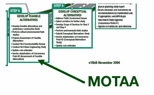
Source: Transportation Research Board 84th Annual Meeting, Session 476: Work Zone Impacts and Mitigation Efforts, How One State DOT is Addressing Work Zone Impacts, Dave Holstein, Ohio Department of Transportation, January 11, 2005, URL: http://webboard.trb.org/file.asp?file=David+Holstein%2Epdf (Requires Login. Accessed May 30, 2006).
Step 5 of 7: Analyze Potential Impacts (Optional)
Typically, work zone impacts assessment is not a major focus of preliminary engineering activities. Many agencies qualitatively identify the potential work zone impacts of the construction project, but do not necessarily analyze the impacts to any degree of detail. However, quantitative analysis does have its benefits, especially because more project-specific information is available during preliminary engineering, and any analysis conducted with this information can help the agency better understand the potential work zone impacts of the project. For example, preliminary engineering site visits, investigations, and conceptual design activities may yield more detailed (project-specific) information on aspects such as the exact scope of work for the project, design concepts, ROW issues, utility issues, environmental issues, traffic data and studies, and base plans. This kind of information is a big step-up from what is normally available in systems planning, and can be very useful to quantitatively understand the work zone impacts of a project before any major design work is accomplished.
In the process diagram (Figure 5.1), this step is shown as a box with dashed lines, which means that this step is optional. It is up to individual agencies to determine (in Step 4) whether or not quantitative analysis is needed, based on the type, complexity, and expected work zone impacts of the project. If it is determined (in Step 4) that further quantitative analysis is not needed, the agency would skip this step and proceed directly to Step 6. At this stage of project development, quantitative impacts analysis may generally be done for significant projects that are expected to have major impacts at the corridor, network, or regional levels, but this does not mean that it will not be needed for other projects. Any decision to analyze or not to analyze should be made on a project-by-project basis.
TIP: Sometimes, quantitative work zone impacts analysis during preliminary engineering may not be possible due to inadequate project detail and lack of data to perform the analysis. In such cases, the particular issue under investigation may be noted so that the staff that conduct assessments in subsequent phases are made aware of the issue.
The following are some examples of scenarios under which an agency may find it helpful to quantitatively analyze impacts during preliminary engineering:
- The preliminary assessment in Step 4 may indicate that the project is a significant project, and the agency may desire to obtain a better (quantitative) understanding of what the impacts may be so that appropriate work zone management strategies and their costs can be identified. This does not automatically mean that quantitative analysis is needed in this step if a project is identified as significant in Step 4; any decision should be made on agency policy and individual project needs.
- It may not be very obvious during the preliminary assessment in Step 4 whether or not a project is significant. So the agency may decide to further analyze the potential work zone impacts. For example, an agency may identify in Step 4 that a particular project would have significant sustained work zone impacts if performed during daytime hours, but likely would not if performed at night. So, in this step the agency may conduct a queuing and delay analysis to determine if it would be feasible to conduct the project at night without an extensive TMP.
- To help the agency choose between multiple project design and construction options. Examples include asphalt pavement vs. concrete pavement, white top vs. black top, narrow shoulders vs. wide shoulders (life-cycle costs), and cast in place concrete vs. pre-fabricated concrete.
The Construction Analysis for Pavement Rehabilitation Strategies (CA4PRS) is a computer model intended to estimate the maximum amount (distance) of highway that can be rehabilitated or reconstructed within various closure timeframes. This model integrates pavement, construction, and traffic-related decision-making by balancing numerous constraints such as scheduling interfaces, pavement materials and design, contractor logistics and resources, and traffic operations. When combined with a traffic model, the CA4PRS software can help determine which pavement structures and rehabilitation strategies maximize on-schedule construction production without creating unacceptable traffic delays.
Source: A Computer Simulation Model: Construction Analysis for Pavement Rehabilitation Strategies (CA4PRS), Report Prepared for California Department of Transportation (Caltrans), E. B. Lee, John Harvey, and C.W. Ibbs, February 2004, University of California at Berkeley, Institute of Transportation Studies, Pavement Research Center. URL: http://www.ce.berkeley.edu/~eblee/CA4PRSModel_Tech_021204.pdf (Accessed 01/06/06).
More information on CA4PRS is available at http://www.dot.ca.gov/newtech/roadway/ca4prs/ca4prs.htm (Accessed 01/06/06), and http://www.ce.berkeley.edu/~eblee/CA4PRS.htm (Accessed 01/06/06).
- To help the agency choose between multiple traffic control and management approaches. Examples include night work vs. daytime work, weekend vs. weekday, lane closure vs. no closure, and full closure vs. partial closure.
- To justify additional funds for work zone transportation management for a particular project or to justify as to why a particular project will not have major impacts. Analyses may help provide hard numbers for the potential work zone impacts, the resulting user-costs, and the amount of user-cost savings that the recommended management strategies may yield.
The following are some issues to be considered in conducting quantitative work zone impacts analysis during preliminary engineering:
- Sketch-planning tools and deterministic tools may be most appropriate for this level of analysis. Quantitative analysis at this stage is generally aimed at estimating the work zone impacts of the project (at a high-level) in and around the work zone, and/or the immediate transportation network within the impactable vicinity of the work zone. Therefore, sketch-planning tools and deterministic tools may be most suitable. Travel demand modeling tools may also be used, but they are generally intended for regional and/or metropolitan level analysis, and may not provide the desired level of analysis clarity. For example, some deterministic tools are capable of replicating and analyzing the impacts of the traffic control plan (TCP) for a project, including taper lengths, number of lanes, lane widths, shoulder widths, turning lanes, traffic signal information; and the use of different management strategies (e.g., ITS, demand management, real-time information.). However, travel demand modeling tools do not have this level of clarity and may not serve the purpose. Also, if agencies are interested in estimates of queue lengths, travel time, and delay, in addition to volume, volume/capacity (V/C) ratios, vehicle miles traveled (VMT), and vehicle hours traveled (VHT), travel demand models may not serve the purpose. This does not mean that travel demand models cannot be used. This decision needs to be made based upon individual project needs and the types of information that the agency is interested in. Using travel demand models for the analysis may be better than conducting no analysis at all. Examples of tools that may be most appropriate for conducting quantitative work zone impacts analysis during preliminary engineering are:
- Work Zone Specific Sketch-Planning Tools such as MicroBENCOST, QuickZone, QUEWZ, and CA4PRS.
- Deterministic/Highway Capacity Manual (HCM) Based Tools such as Highway Capacity Software (HCS 2000), Assessment of Roundabout Capacity and Delay (ARCADY), Freeway Delay Calculation Program (FREWAY), and Dynamic Toll Plaza Queuing Analysis Program (Dqueue).
- Generic Sketch-Planning Tools such as the ITS Deployment Analysis System (IDAS), Screening for ITS (SCRITS), and IMPACTS.
If the project complexity and the desired level of accuracy for the work zone impacts estimation warrant a more detailed analysis (e.g., simulation), the agency may choose to do so depending on the availability of the data needed to conduct a low-level analysis. A traffic simulation tool like CORSIM would require additional information including trip tables, origin-destination patterns, and more details on the traffic control parameters. At the preliminary engineering stage, such detail may not always be available, and therefore simulation tools may not be suitable for this analysis. They may however be appropriate for use on larger projects where both preliminary engineering and design may take place in tandem.
QuickZone is a work zone delay estimation model developed by the Federal Highway Administration's (FHWA) Research, Development and Technology (RD&T) program. QuickZone helps project planners and engineers estimate delay, queuing and user costs associated with alternate work zone design and mitigation strategies. The kind of input data required include basic network definition data, traffic counts, high level work zone configuration (e.g., lane-closure details), and construction times. The user may add specific transportation management strategies, e.g., ITS, public information, and demand management strategies to estimate the benefits that may be obtained. Based on this information, the user may then run multiple scenario analyses to estimate delay, queuing, and user-costs of different potential construction and management strategies. More information on QuickZone is available at https://www.fhwa.dot.gov/research/topics/operations/travelanalysis/quickzone/ (Accessed 01/06/06).
More information on analysis tools is provided in APPENDIX B – Overview of Work Zone Impacts Analysis Tools.
- The analysis may be performed at the work zone, corridor, and/or network levels. Appropriate measures may be considered in the analysis for safety, mobility, societal impacts, road user-costs, life-cycle cost implications, and benefits of the work zone management strategies. Examples of different work zone impacts issues and measures are provided in the systems planning process description, under Step 3 of 6, in Section 4.5.
- The analysis may be combined with an ongoing project study such as corridor/sub-area study, EIS, etc. Environmental/NEPA assessments must cover the range of impacts of the project, and address issues such as design alternatives that would decrease pollution emissions, construction impacts, esthetic intrusion, relocation assistance, possible land use controls that could be enacted, and other possible efforts. Any work zone impacts analysis that is conducted during preliminary engineering may be combined with other such project assessments, can provide information towards effective completion of other assessments, and can use information and constraints that come out of the other assessments.
The New York State Thruway Authority (NYSTA) is studying the reconstruction of the NYS Thruway between Interchanges 23 and 24 to improve deteriorating conditions on the underlying roadway. Construction is expected to begin sometime in 2007, and the project is currently in the environmental study and review phase. An environmental assessment conducted by the NYSTA indicated potential impacts to wetlands, noise levels, increased storm water discharge, and archeological sites. Therefore a positive declaration was made to prepare an Environmental Impact Statement (EIS). Preliminary assessments indicate that if the proposed project goes forward an additional temporary lane may be required to maintain traffic during construction. The temporary lane may be converted to a permanent lane if the study concludes that this is the preferred alternative. The EIS scope identifies the need to examine the impacts of construction activities in and adjacent to the project area and identify appropriate mitigation strategies. The types of construction impacts to be considered include accidental spills including fuel spills; temporarily increased noise levels; temporarily degraded air quality; temporarily increased levels of dust in the air; erosion and sediment control; and traffic congestion.
Source: New York State Thruway Authority's web site for the Thruway Reconstruction Project between Interchanges 23 and 24. URL: http://www.thruway.state.ny.us/projectsandstudies/projects/i23-i24/index.html (Accessed 01/06/06).
Once the work zone impacts analysis is complete, appropriate work zone transportation management strategies may then be identified in Step 6. The link between Steps 5 and 6 is bi-directional as it represents an iterative process to conduct the work zone impacts analysis in conjunction with the work zone management strategies. For example, if a work zone traffic incident management plan is chosen as a strategy, the agency may perform a scenario analysis to estimate its benefits in terms of mitigating the work zone impacts of the project.
Step 6 of 7: Identify Preliminary Work Zone Management Strategies
This step involves the preliminary identification of potential work zone management strategies based on the impact assessments conducted in the previous steps. Agencies may arrive at this step directly after the preliminary assessment in Step 4, or after conducting further quantitative analysis in Step 5. In either case, at this point enough information should be available on the project with regards to the potential design, construction/staging, overall work zone/traffic control approach, environmental issues, other coordination issues (utility, ROW, community/business impacts, etc.), and the resultant work zone impacts of the project. This information will be used to identify the management strategies and estimate their costs sufficiently enough to initiate the implementation plans for those management strategies.
The objective of this step is not to develop the TMP but to identify the potential management strategies that could constitute the TMP and take the necessary actions that set the basis for TMP development in subsequent design stages. So, the level of effort is expected to be minimal compared to that required for actual design and development. Often, it may just involve a compilation of the work zone impacts issues, quick identification of appropriate management strategies, estimation of their costs based on simplistic procedures and available data, and identifying resources and means to implement them. The discussion on identification of management strategies provided under Step 4 of 6 of the systems planning process in Section 4.5 can be used as a framework for identifying the management strategies.
This step may seem identical to the Step 4 of the systems planning process – and appropriately so, because the objective of this step and that of Step 4 of systems planning is essentially the same, which is to identify work zone management strategies for the project. The biggest difference is in the level of work zone impacts assessment. In systems planning the focus is on getting a conceptual understanding; whereas in preliminary engineering, the focus is on using more project-specific information to conduct the preliminary activities that help set the tone for actual design in subsequent stages. Another aspect to note in preliminary engineering is that in addition to identifying management strategies and estimating their costs, implementation plans for the management strategies are also initiated. For example, the management strategies that are identified in this step may include a work zone traffic monitoring system, work zone traffic incident management program, and a public information campaign including a web-based traveler information program. As part of initiating the implementation plan for the management strategies, the agency may investigate the possibility of using pre-existing traffic surveillance and detection devices for work zone traffic monitoring, initiate contacts with the agency's traffic operations group to develop concepts for the work zone traffic incident management program, and initiate discussions with the agency's information systems group to setup a web site for the project.
More detailed information about the different work zone management strategies is provided in Developing and Implementing Transportation Management Plans for Work Zones, available at http://www.ops.fhwa.dot.gov/wz/resources/final_rule.htm (Accessed 1/18/06).
Step 7 of 7: Compile Preliminary Work Zone Strategy
In this step, the information from the impact assessment conducted in the previous steps is compiled to develop a "Preliminary Work Zone Strategy" which consists of:
- The project definition.
- Candidate construction/staging and traffic control approaches.
- Anticipated/estimated work zone impacts.
- Preliminary transportation management strategies.
- Cost estimate for the transportation management strategies (may be one or multiple sets of strategies, depending upon whether there is more than one construction/staging alternative).
- High-level identification of implementation resources, challenges, and opportunities, and initiation of appropriate action items for the management strategies.
Potential coordination and/or conflicts with other projects may also be addressed. The alternative(s) that best suits the needs of constructability, safety, and mobility should be selected. In some instances, it may not be clearly evident that one particular alternative is most appropriate, in which case, multiple alternatives may be carried over to the design phase where more detailed investigation and analyses may be performed.
- A significant project is one that, alone or in combination with other concurrent projects nearby is anticipated to cause sustained work zone impacts that are greater than what is considered tolerable based on the respective agency's policy and/or engineering judgment. This definition, provided in Section 630.1010 of the Work Zone Safety and Mobility Rule (the Rule), also specifies that all Interstate system projects within the boundaries of a Transportation Management Area that occupy a location for more than three days and have lane closures are significant.
![]() You
will need the Adobe
Reader to view the PDFs on this page.
You
will need the Adobe
Reader to view the PDFs on this page.