1.0 Project Overview
The California Department of Transportation (Caltrans) State Route (SR) 41 operational improvement project is located in Fresno, California. The total project covers approximately 1.3 miles of SR 41 between Herndon Avenue and Friant Road. Due to funding constraints the project was divided into two phases, each treated as separate projects. The discussion in this example focuses on Phase 1 of the project, which was constructed in May 2006. The Phase 1 project limit was about 0.6 miles of SR 41 between Alluvial Avenue and Friant Road. This section of SR 41 is a major north-south commuter route in Fresno, providing access to downtown business and industrial areas. It is located in an urban area with congestion during the peak periods of travel. Prior to this project, northbound SR 41 was a three-lane facility with a transition to two-lanes at El Paso Avenue. The objective of this project was to reduce traffic delay and congestion along northbound SR 41. The primary source of the congestion was traffic backing up on northbound SR 41 (mainline) due to traffic exiting at Friant Road, one of the busiest off-ramps in metropolitan Fresno (especially during the afternoon peak period).
Figure 1 presents a Project Location Map showing the SR 41 corridor between Herndon Avenue and Friant Road.
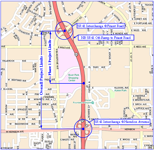
Figure 1. Project Map Showing SR 41 between Herndon Avenue and Friant Road
Prior to this project, there was only one northbound lane exiting the mainline at Friant Road. Operational and delay analyses conducted by the Caltrans Office of Traffic Operations indicated that 65% of northbound SR 41 traffic exits the mainline at Friant Road during the PM peak hour, leading to demand much in excess of off-ramp capacity and resulting in a Level of Service (LOS) F[1] for the off-ramp. This problem was also compounded by congestion on Friant Road at the adjacent intersections. Further, the inadequate off-ramp capacity led to additional operational and safety concerns including extensive queuing onto the mainline, delays to through traffic on the mainline, abrupt traffic flow stops and surges, erratic maneuvers, and traffic backup on the mainline all the way to the Herndon Avenue on-ramp.
As a result, Caltrans decided to perform operational improvements at the northbound SR 41 off-ramp to Friant Road and to mainline SR 41 between Herndon Avenue and Friant Road.
Key improvements included:
- Widening the SR 41 off-ramp to five lanes at the intersection with Friant Road.
- Adding an auxiliary lane on northbound SR 41 from Herndon Avenue to Friant Road.
- Adding a second auxiliary lane on northbound SR 41 from Alluvial Avenue to Friant Road.
- Adding a traffic lane in the median on SR 41 from El Paso Avenue to just north of Friant Road to handle stage construction traffic. After the construction project was completed, this median lane would be converted to a wide inside shoulder, which could be used as a traffic lane in the future (if needed).
The overall project was divided into two phases (treated as separate projects) due to funding constraints. The discussion in this example focuses on the first phase, which was completed in May 2006. The second phase is currently in the design stage and is expected to be constructed in 2007. The following reconstruction activities were performed as part of the first phase:
- Adding a median lane on SR-41 from El Paso Avenue to approximately 0.1 km North of Nees Avenue.
- Adding an auxiliary lane on SR-41 from 0.2 km North of Alluvial Avenue to NB off-ramp to Friant Road.
- Widening two structures at El Paso Avenue and Nees Avenue to accommodate the auxiliary lane and median lane.
The total number of working days to construct the project was 340 days at an estimated construction cost of $7.5 Million. The cost of the work zone Transportation Management Plan (TMP) for this project was $70,000[2] and included a public information/awareness campaign, motorist information strategies, incident management, and construction strategies.
- Level of Service (LOS) is an indication of congestion, traffic flow, and mobility performance of a road facility. LOS indicators range from LOS A to LOS F, with A representing free flow conditions (no congestion), and F representing extreme congestion. When the LOS of a highway facility reaches F, it indicates that traffic demand is well in excess of capacity, and the resulting delays to motorists are intolerable. More information on highway capacity and LOS is available in the Highway Capacity Manual (HCM) 2000, which may be purchased at http://www.trb.org/news/blurb_detail.asp?id=1166 (Accessed 9/27/06).
- The FHWA definition of TMP includes the Temporary Traffic Control (TTC) Plan, and the Transportation Operations (TO) and Public Information (PI) components. Caltrans however does not include the cost of the basic TTC Plan in the cost estimate for the TMP, but rather considers only the cost of additional management strategies beyond the TTC Plan. It is important to note this distinction.