F. Sample TMP 2 Moderate-to-Major Impacts with Appendices
Table of Contents
2.0 TMP Team—Roles and Responsibilities
4.0 Operational Analysis—Existing
5.0 Work Zone Impact Management Strategies
5.1. Temporary Traffic Control Plan
6.0 TMP Implementation/Monitoring
Project Name: Replacement of 1-94 Bridges over Riverside Drive Battle Creek, Michigan
Executive Summary
This sample was developed based on the Transportation Management Plan (TMP) created for the replacement of I-94 bridges over Riverside Drive in Battle Creek, Michigan. Replacement of the I-94 bridges is expected to create significant impacts in the vicinity of the project. This TMP shows the analysis of alternate traffic control schemes, the anticipated impacts of the construction, and the strategies that will be deployed to mitigate the impacts.[1]
1.0 Project Description
The proposed project consists of two projects combined because of location. The first is the replacement of the two I-94 bridges over Riverside Drive. The second project is a cracks-per-mile (CPM) cold mill and single course hot-mix asphalt (HMA) overlay of I-94 EB and WB from Helmer Road to 6½ Mile Road, including ramps and rest area repairs.
This is a significant project based on the criteria specified in the Michigan Work Zone Safety and Mobility Manual.[2] Thus, the TMP is comprised of all three components:
- Temporary Traffic Control Plan (TTCP)
- Transportation Operations Plan (TOP)
- Public Information Plan (PIP).
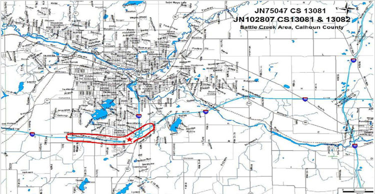
Vicinity Map
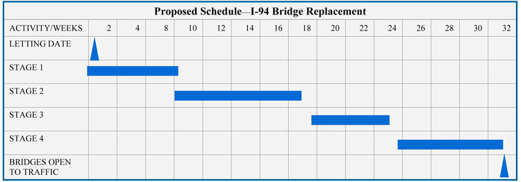
Project Schedule: The proposed construction phasing consists of four stages, as illustrated by the schedule below:
2.0 TMP Team—Roles and Responsibilities
| Name: Daniel Xxxxx[3] Unit: MDOT Phone: 517-242-XXXX Email: danielx@michigan.gov |
| Roles and Responsibilities: Ensure TMP Compliance with the Work Zone Safety and Mobility Policy. Coordinate the PIP completion with the communication representative. |
| Name (TSC Staff Lead): Leslie Xxxxx Unit: TSC Phone: 517-242-XXXX Email: lesliex@michigan.gov |
| Roles and Responsibilities: Identify and propose mitigation activities to be included in the TMP in subsequent project development phases. Develop the project-level TMP, Temporary Traffic Control Plan (TTCP), Transportation Operations Plan (TOP), and Public Information Plan (PIP) for significant projects. Conduct capacity analysis using the CO3 (Construction, congestion, Cost) program or comparable project-level models. |
| Name: George Xxxxx Unit: TSC Phone: 517-242-XXXX Email: georgex@michigan.gov |
| Roles and Responsibilities: Ensure all aspects of TMP comply with the Work Zone Safety and Mobility Policy during the construction, which includes monitoring, analyzing, and documenting mobility criteria in the TMP and crash numbers once implemented. |
| Name: Marshall Xxxxx Unit: TSC Phone: 517-242-XXXX Email: marshallx@michigan.gov |
| Roles and Responsibilities: Ensure all State and contract maintenance activity is conducted in accordance with the Work Zone Safety and Mobility Policy. |
| MDOT | Consultant |
|---|---|
| Name: William Xxxxx Unit: MDOT Phone: 517-242-XXXX Email: williamx@michigan.gov |
Name: Mesfin Xxxxx Phone: 517-242-XXXX Email: mesfinx@eng.com |
| Roles and Responsibilities: Provide real-time public awareness of the work zone. | |
| Name: Greer xxxx Unit: TSC (Delivery Engineer) Phone: 517-242-XXXX Email: greerx@michigan.gov |
| Roles and Responsibilities: Respond in case of an emergency or unexpected event such as accidents, major traffic delays, etc. |
3.0 Existing Conditions
I-94 is a multilane freeway with two lanes in each direction. Table 1 provides a summary of the roadway characteristics. Appendix A provides hourly count reports.
| Control Section, Roadway | 13081, I-94 Bridges over Riverside Drive (Bridge Replacement) |
13081, I-94 by Riverside Bridges (CPM Mill and Fill) |
13082, I-94 East of I-194/M66 (CPM Mill and Fill) |
|---|---|---|---|
| Road Type | 4 Lane Freeway | 4 Lane Freeway | 4 Lane Freeway |
| Existing Lane Configuration | 2 Lanes Eastbound & 2 Lanes Westbound | 2 Lanes Eastbound & 2 Lanes Westbound | 2 Lanes Eastbound & 2 Lanes Westbound |
| Proposed Lane Configuration | 2 | 1 (for nonrestricted hours only) | 1 (for nonrestricted hours only) |
| ADT | 55,800 | 55,800 | 50,400 |
| % Commercial | 25% | 25% | 24% |
| Expected % Diversion | 5% | 0% | 0% |
| Existing PHV (V/C) | 0.90 | 0.90 | 0.75 |
| Existing PHV LOS | D | E | C |
4.0 Operational Analysis—Existing
This section analyzes the existing safety and traffic conditions within the project influence area.
4.1. Safety Analysis
A Crash Analysis & Safety Review was conducted for I-94 EB & WB (from Helmer Road to 6½ Mile Road), for the 3-year period (January 1, 2005—December 31, 2007), using the MDOT Transportation Management System (TMS) database. The segment analyzed was approximately 0.25 miles before and after the point of beginning (POB) and point of end (POE). Table 2 below provides a summary of crashes. Fixed object, animal crashes, and rear-end crashes are the predominant crash types. Additional details on the analysis are provided in Appendix B.
| Crash Type | Crash Count | Percentage |
|---|---|---|
| Fixed Object | 97 | 28.28 |
| Animal | 56 | 16.33 |
| Rear-End Straight | 52 | 15.16 |
| Sideswipe Same | 38 | 11.08 |
| Miscellaneous One Vehicle | 28 | 8.16 |
| Overturn | 28 | 8.16 |
| Other Object | 21 | 6.12 |
| Angle Straight | 9 | 2.62 |
| Rear-End Right Turn | 4 | 1.17 |
| Head-On | 3 | 0.87 |
| Sideswipe Opposite | 3 | 0.87 |
| Rear-End Left Turn | 1 | 0.29 |
| Angle Turn | 1 | 0.29 |
4.2. Traffic Analysis
4.2.1. Data Collection and Traffic Modeling Approach
The CO3 model[4] was used to model traffic delay, user cost, and construction cost for construction and maintenance operations. In addition, LOS charts were generated based on Highway Capacity Manual.
The traffic data for analyses was obtained from hourly count reports provided by the MDOT Bureau of Transportation Planning. Appendix B provides the traffic counts and Appendix C shows the detailed reports.
Output data from the CO3 software and LOS Charts were used to describe the operation of the control sections 13081 (I-94 bridges over Riverside Drive) and 13082 (I-94 East of I-194/M66). Measures of Effectiveness considered are:
- Vehicle delay (in minutes)
- V/C ratio
- Level of Service
- Maximum backup length (in miles).
4.2.2. Alternatives/Impact Assessment
The project team considered different alternatives on how to balance cost and mobility. CO3 models were run based on these alternatives. The selection of alternatives was based on a combination of qualitative and quantitative analysis.
Alternatives Considered
To possibly minimize the impact on user mobility, the following alternative traffic control schemes were evaluated for replacing the I-94 bridges over Riverside Drive project:
- Detour existing I-94 traffic to other routes: I-94 has an average daily traffic (ADT) of 55,800 vehicles per day (VPD). This alternative was not feasible because detouring high volumes to existing routes would result in unacceptable delays and congestion on the surrounding road network.
- Construct a temporary bridge: This alternative was cost-prohibitive because of the steep grades and existing interchanges close to the bridge.
- One lane with alternating traffic on Riverside Drive during construction: This alternative would potentially increase project construction duration to two construction seasons.
- Part-width Construction: Construction would be performed as part-width to maintain two 11-ft lanes with 1-ft shy distance in each direction (EB & WB) at all times for I-94. Riverside Drive would be closed and detoured.
Selected Traffic Control Scheme for I-94 Bridge Replacement over Riverside Drive
The selected alternative provides a project solution that not only meets and exceeds the final goals of the project, but one that could also be constructed with minimal impact to the surrounding roadway network and the roadways within the project limits. Part-width construction as detailed in alternative 4 above was selected. Traffic staging for this alternative includes:
- Stage 1: Shift two lanes of traffic in each direction (EB &WB) to the outside lane of the existing bridges. Remove inside portion of each bridge.
- Stage 2: Traffic remains shifted to the outside lanes of the existing bridges. Construct the new inside portion of bridge wide enough for two lanes of traffic in Stage 3.
- Stage 3: Shift two lanes of traffic to the inside lanes of the newly constructed bridges. Remove the outside portion of each existing bridge.
- Stage 4: Traffic remains shifted to inside of newly constructed bridge. Construct new outside portion of the bridge.
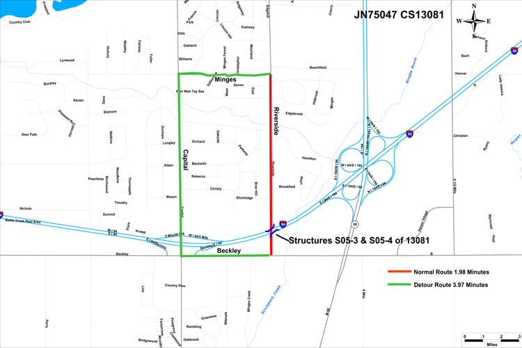
Riverside Drive Detour
The proposed detour route is Minges Road to Capital Avenue to Beckley Road. The travel time along the existing route is 1.98 minutes and the travel time of the detour route is 3.97 minutes, a difference of only 1.99 minutes. The detour route will be reviewed to determine the need for new/additional signing and pavement markings, including detour guide signs, detour ramp gore signs, and two portable changeable message signs providing warning messages one week prior to and during the detour. The City of Battle Creek approved the detour route. During construction, access to all business and residential drives will be maintained.
Selected Traffic Control Scheme for I-94 CPM Project from Helmer Road to M-66
The CPM paving operations will be performed at night (Sunday through Thursday). During certain periods while paving operations are under way, roadway performance will decrease to LOS D and E due to time needed for constructability/production each night. The time restrictions for this project only permit an 11 hour work period for temporary traffic control setup, paving, stripping of temporary pavement markings, and removal of temporary traffic control. The contractor will pave one lane and a shoulder with a tapered overlapping centerline longitudinal joint. The following night the contractor will pave the adjacent lane. Table 3 provides a summary of Measures of Effectiveness (MOEs) for existing and proposed construction conditions for the affected roadways.
| Hourly Capacity |
Peak Hourly Volume (PHV) |
PHV V/C | PHV LOS | Average Delay |
Peak Hour Delay |
Maximum Back Up Length |
||||||||||
|---|---|---|---|---|---|---|---|---|---|---|---|---|---|---|---|---|
| Control Section, Roadway | Existing | Proposed | Existing | Proposed | Existing | Proposed | Existing | Proposed | Proposed (minutes) |
Proposed (minutes) |
Proposed (miles) |
|||||
| WD | WE | WD | WE | WD | WE | WD | WE | WD | WE | |||||||
| 13081, I-94 by Riverside Bridge (Bridge Replacement) |
3,424 | 2,732 | 3,090 | 3,090 | 2,485 | 0.90 | 1.13 | 0.91 | D | E | 0.9 | 1.0 | 1.4 | 1.4 | 0.0 | 0.0 |
| 13081, I-94 by Riverside Bridge (CPM Mill and Fill) |
3,424 | 1,387 | 3,090 | 2,176 | 1,855 | 0.90 | 1.57 | 1.34 | D | E | 1.4 | 3.9 | 18.4 | 40.5 | 2.2 | 5.1 |
| 13082, I-94 East of I-194/M66 (CPM Mill and Fill) |
3,424 | 1,387 | 2,581 | 1,950 | – | 0.75 | 1.41 | – | C | E | 1.4 | – | 18.4 | – | 2.2 | – |
|
||||||||||||||||
Appendix C presents detailed analysis reports.
5.0 Work Zone Impact Management Strategies
Work zone impact management strategies are intended to provide mobility and access in and around the construction area without compromising public safety. The strategies are grouped according to the following three categories:
- Maintenance of Traffic (MOT)/Temporary Traffic Control Plan (TTCP)
- Transportation Operations Plan (TOP)
- Public Information Plan (PIP).
5.1. Temporary Traffic Control Plan
The MOT concept described recommends the use of the following measures to maximize work zone safety and minimize impacts on user mobility:
- Conduct an initial Plan Review meeting for the I-94 Bridges over Riverside Road project.
- Provide adequate lateral and longitudinal buffers during active work periods to maximize user mobility and worker safety.
- Provide positive separation between traffic and the work area using temporary concrete barrier, with attenuator.
Notes:
- Appendix D provides information on contracting clauses.
- Appendix E provides the MOT plans and detour plan sheet.
- Appendix F provides design plans/typical.
- See section 4.2.2 for selected traffic control schemes for Riverside Bridge Project and the CPM Project.
5.2. Transportation Operations Plan
The general strategies for operations and management of the work zones include:
- Air traffic will not be affected.
- Work will be suspended during holiday periods, as defined by the project engineer. All work shall be coordinated around local festivals.
- Custom signs, (RUMBLE STRIPS) and (ATTENTION MOTORCYCLISTS) signs included in the quantities should be placed as the lead signs in the sign sequence when traffic is shifted. These signs will be placed on both sides of the roadway.
- W20-15b (WATCH FOR TRAFFIC BACKUPS/BE PREPARED TO STOP) signs should be placed at the Point of Beginning (POB) for WB and POB for EB and 5 miles in advance of each POB on the right and left of the roadway.
- A minimum of two R11-4MOD (OVERWIDTH VEHICLES PROHIBITED/10-FOOT MAXIMUM WIDTH) signs should be placed (1) at ½ mile before the interchange of I-94BL/M-37/Columbia Ave/Skyline/Martin Luther King Blvd/Exit 92 (eastbound) and (2) in advance of the interchange of M-294/Beadle Lake Road/Exit 100 (westbound).
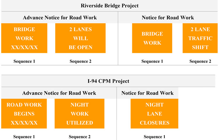
- Portable Changeable Message Signs (PCMS) will be used to warn traffic of upcoming work and changing traffic control during the life of the project. The PCMS will be installed and operational a minimum of 7 calendar days prior to the start of work. The proposed PCMS message sequence to be used is given below:
- Notify the Battle Creek Area Transit Authority in advance of any roadway maintaining traffic changes to decrease any impacts to normal transit routes.
- Law enforcement will be asked to provide patrol of the work zone.
- Restrict access for construction vehicles between traveled lanes and work areas to specific locations. The number of access points and their locations require prior approval from the Engineer.
The strategies for operations and management of the I-94 CPM Project are as follows:
- Maintain two lanes of traffic on I-94 during the following hours:
- Monday through Thursday, 6:00 a.m. to 7:00 p.m.
- Friday, 6:00 a.m. to 9:00 p.m.
- Saturday, 8:00 a.m. to 7:00 p.m.
- Sunday, noon to 9:00 p.m.
- Remove all signs and traffic control devices during the hours of the above lane restrictions, according to the special provision for temporary removal of portable signs. If the signs are displayed during the restricted hours, then the contractor is charged liquidated damages of $333 for every 15 minutes the signs are displayed.
- Provide transverse and longitudinal HMA tapers at all grade changes caused by cold milling and overlays. Pave all cold-milled areas the same day as the cold milling operation is performed. Allow no traffic on the cold-milled surface, unless otherwise approved by the Engineer.
- Place lighted plastic drums for the WHOLE length of the project on BOTH sides of the EB and WB I-94.
- When not in use, store the lighted plastic drums along the edge of the shoulders. Do not drag drums across open lanes of traffic on a routine basis.
- During the paving operation, when the lap joint will be exposed to traffic, place a solid white lane line on the tapered portion of the joint, in addition to the solid white edgeline. Within the following work period, after the contractor has paved the adjacent lane to previous paving length, place a dashed white lane and 4-ft strips on 50-ft centers to delineate the center line, in addition to the solid yellow edgeline.
- Place temporary pavement markings, Type NR paint, 4-inch white at 4-ft skips on 50-ft centers to delineate the centerline, prior to opening to traffic, at the end of each work night.
- Place Temporary Paint (Type NR paint, 4-inch white and 4-inch yellow) to delineate the edge of the roadway lanes after each HMA course at the end of EACH working night, prior to opening to traffic.
Incident Management Plan
- Install permanent emergency routes signs along the I-94 corridor in the project limits to provide motorist guidance in the event of a traffic incident.
- Maintain access for emergency vehicles at all times through coordination with the MDOT construction staff.
5.3. Public Information Plan
The following strategies will be used to inform the public and stakeholders about the project:
- Circulate a project brochure detailing the type of project, the traffic control required to construct the job, and the time the project is expected to last.
- Issue a press release before the project begins detailing the type of project, the traffic control required to construct the job, and the time the project is expected to last.
- Keep the MDOT lane closure website up to date.
- Attend Neighborhood Planning Counsel Meeting(s) to describe the upcoming project, provide status, and receive feedback.
- Use portable changeable message signs (PCMS) to notify road users of upcoming work and changing traffic control throughout the life of the project. Install the PCMS and keep operational a minimum of 7 calendar days prior to the start of work. Table 4 provides a summary of work zone impact management strategies.
| Temporary Traffic Control | Cost | |
|---|---|---|
| Control Strategies | ||
| 1. Construction phasing/staging | ||
| 2. Full roadway closures | ||
| 3. Lane shifts or closures | ||
| 4. One-lane, two-way controlled operation | ||
| 5. Two-way, one-lane traffic/reversible lanes | ||
| 6. Ramp closures/relocation | ||
| 7. Freeway-to-freeway interchange closures | ||
| 8. Night work | ||
| 9. Weekend work | ||
| 10. Work hour restrictions for peak travel | ||
| 11. Pedestrian/bicycle access improvements | ||
| 12. Business access improvements | ||
| 13. Off-site detours/use of alternate routes | ||
| Traffic Control Devices | ||
| 14. Temporary signs | 300-500 | |
| 15. Arrow boards | 5,000-10,000 | |
| 16. Channelizing devices | ||
| 17. Temporary pavement markings | ||
| 18. Flaggers and uniformed traffic control officers | ||
| 19. Temporary traffic signals | 100,000-250,000 | |
| 20. Lighting devices | ||
| Project Coordination Strategies | ||
| 21. Other area projects | ||
| 22. Utilities | ||
| 23. Right-of-Way | ||
| 24. Other transportation infrastructure | ||
| Innovative Contracting Strategies | ||
| 25. Design-Build | ||
| 26. A+B Bidding | ||
| 27. Incentive/Disincentive clauses | ||
| 28. Lane rental | ||
| 29. Performance specifications | ||
| Innovative or Accelerated Construction Techniques | ||
| 30. Prefabricated/precast elements | ||
| 31. Rapid cure materials | ||
| Transportation Operations | Cost | |
|---|---|---|
| Demand Management Strategies | ||
| 1. Transit service improvements | ||
| 2. Transit incentives | ||
| 3. Shuttle services | ||
| 4. Parking supply management | ||
| 5. Variable work hours | ||
| 6. Telecommuting | ||
| 7. Ridesharing/carpooling incentives | ||
| 8. Park-and-Ride promotion | ||
| Corridor/Network Management Strategies | ||
| 9. Signal timing/coordination improvements | ||
| 10. Temporary traffic signals | ||
| 11. Street/intersection improvements | ||
| 12. Bus turnouts | ||
| 13. Turn restrictions | ||
| 14. Parking restrictions | ||
| 15. Truck/heavy vehicle restrictions | ||
| 16. Reversible lanes | ||
| 17. Dynamic lane closure system | ||
| 18. Ramp closures | ||
| 19. Railroad crossing controls | ||
| 20. Coordination with adjacent construction site(s) | ||
| Work Zone ITS Strategies | ||
| 21. Late lane merge | ||
| 22. PCMS with speed display | 20,000/each | |
| 23. Travel time estimation system | ||
| 24. Advanced speed information system | ||
| 25. Advanced congestion warning system | ||
| 26. Conflict warning system (e.g., construction vehicles entering roadway) | ||
| 27. Travel time monitor system | ||
| 28. Freeway queue monitor system | ||
| 29. CCTV monitoring | ||
| 30. Real-time detour | ||
| Work Zone Safety Management Strategies | ||
| 31. Speed limit reduction/variable speed limits | ||
| 32. Temporary traffic signals | ||
| 33. Temporary traffic barrier | ||
| 34. Movable traffic barrier systems | ||
| 35. Crash cushions | ||
| 36. Temporary rumble strips | ||
| 37. Intrusion alarms | ||
| 38. Warning lights | ||
| 39. Automated flagger assistance devices (AFADs) | ||
| 40. Project task force/committee | ||
| 41. Construction safety supervisors/inspectors | ||
| 42. Road safety audits | ||
| 43. TMP monitor/inspection team | ||
| Incident Management and Enforcement Strategies | ||
| 44. ITS for traffic monitoring/management | ||
| 45. TMC | ||
| 46. Surveillance (e.g., CCTV) | $5,000-7,000/ each |
|
| 47. Helicopter for aerial surveillance | ||
| 48. Traffic Screens | ||
| 49. Call boxes | ||
| 50. Mile-post markers | ||
| 51. Tow/freeway service patrol | ||
| 52. Total station units | ||
| 53. Photogrammetry | ||
| 54. Media coordination | 250,000-500,000/ year |
|
| 55. Local detour routes | ||
| 56. Contract support for Incident Management | ||
| 57. Incident/Emergency management coordination | ||
| 58. Incident/Emergency response plan | ||
| 59. Dedicated (paid) police enforcement | ||
| 60. Cooperative police enforcement | ||
| 61. Automated enforcement | ||
| 62. Increased penalties for work zone violations | ||
| 63. Emergency pull-offs | ||
| Public Information and Outreach | Cost | |
|---|---|---|
| Public Awareness Strategies | ||
| 1. Branding | ||
| 2. Press kits | ||
| 3. Brochures and mailers | 2,000-5,000/ each |
|
| 4. Press releases/media alerts | ||
| 5. Mass media (earned and/or paid) | ||
| 6. Paid advertisements | 3,000-5,000/ 15 seconds |
|
| 7. Project Information Center | ||
| 8. Telephone hotline | ||
| 9. Planned lane closure website | ||
| 10. Project website | 20,000-25,000/ initial setup |
|
| 11. Public meetings/hearings, workshops | ||
| 12. Community task forces | ||
| 13. Coordination with media/schools/business/emergency services | ||
| 14. Work zone education and safety campaigns | ||
| 15. Work zone safety highway signs | ||
| 16. Rideshare promotions | ||
| 17. Visual information | ||
| Motorist Information Strategies | ||
| 18. Radio traffic news | ||
| 19. Changeable message signs | 18,000-20,000/ each |
|
| 20. Temporary motorist information signs | ||
| 21. Dynamic speed message sign | 6,000-8,000/ each |
|
| 22. Highway Advisory Radio (HAR) | ||
| 23. Extinguishable Signs | ||
| 24. Highway information network (web-based) | ||
| 25. Traveler information systems(wireless, handheld) | ||
| 26. Transportation Management Center (TMC) | ||
| 27. Live traffic camera(s) on a website | ||
| 28. Project information hotline | ||
| 29. Email alerts | ||
6.0 TMP Implementation/Monitoring
In accordance with the MDOT Work Zone Safety and Mobility Manual, work zone monitoring will be completed by the region/TSC traffic and safety engineer. After initial implementation of the TMP, traffic delay monitoring, analysis and documentation are required during the life of the project. In addition, work zone crashes are to be documented and an analysis should be conducted to ensure that crash numbers have not increased. If monitoring of the work zone indicates that the actual delay times have exceeded the threshold limits anticipated or crash numbers have increased, then the need for adjustments in the TOP is to be considered.
7.0 TMP Review/Approvals
Note: In Michigan, the region engineer and region system manager are notified if after all mitigation measures have been applied, the project is still expected to exceed the mobility threshold limits (see footnote 2, page 1), or the TMP costs exceed 25% of the projects costs. The region is then responsible for contacting the Safety and Mobility Peer Team (SMPT) for a project review. The purpose of the SMPT is to conduct independent reviews and/or inspections of projects and provide recommendations to the Chief Operations Officer for approval before any implementations are made. See Appendix G for a sample Safety and Mobility Peer Team Review for this project.
8.0 Appendices
B. Crash Analysis & Safety Review
E. Maintenance of Traffic Concept/Typical
G. Safety and Mobility Peer Team Review
- The scope, content, and level of detail of a TMP should vary based on the size, location, complexity, and expected level and range of impacts of a project. Depending on these project characteristics, a TMP for a moderate-to-major impact project may have more or less analysis and detail than this sample.
- A non-traffic regulating operation project in Michigan is to be considered potentially significant if any of the following apply:
- Any project that occupies a specific location for more than three days, with either intermittent or continuous lane closures;
- Any project that, alone or in combination with other nearby or concurrent projects, is anticipated to cause sustained work zone impacts that are greater than what is considered tolerable. This will be based on an assessment of work zone safety and mobility impacts (volume/capacity, travel time, and level of service);
- Any project defined as "potentially significant" or "critical" by region staff.
All potentially significant projects in Michigan are to be further evaluated for possible mobility impacts to the transportation system by comparison with the thresholds for the following critical evaluation criteria:
- Volume to Capacity: Threshold—greater than 0.80.
- Travel Time: Threshold—greater than 10 minutes.
- Level of Service: Threshold—level of service drops 2 or more levels. For example, level of service A to C or C to E.
- Team member information is omitted. The information shown is for demonstration purposes only.
- The CO3 Model is a tool that engineers can use to estimate the magnitude and impacts of traffic congestion, including its cost impact on road users, that can be expected during a construction project. CO3 enables engineers to include construction congestion and its costs to users as an important variable in all project decisions, and helps in selecting among alternative methods of maintaining traffic during construction.
- The strategies and sample cost shown are for demonstration purposes only. When the TMP is incorporated in the contract documents, the cost items typically are not shown.