Work Zone Impacts Assessment:
Example Work Zone Impacts Assessment for a Minor/Basic Project: Washington State Department of Transportation, SR 112 Bear Creek Culvert Replacement Project
March 30, 2007
Acknowledgments
The project team is grateful to the Washington State Department of Transportation (WSDOT) for committing their time and effort towards the success of this example project write-up. Comprehensive work zone impacts assessment for road construction is an emerging area, and the Federal Highway Administration (FHWA) would like to thank the WSDOT for sharing their insights and practices on this very relevant topic. Specifically, the project team would like to recognize the following WSDOT personnel and thank them for their assistance:
- Frank Newboles, WSDOT, State Traffic Control Engineer; and
- Steve Haapala, WSDOT, Olympic Region Traffic Design Office.
Mr. Steve Haapala served as the primary liaison between the project team and WSDOT. Mr. Haapala provided us extensive information on the SR 112 project, participated in several phone calls, and also obtained additional information on request. His overall understanding and knowledge about the SR 112 project, timely contributions, and willingness to further the practice of work transportation management were key to the successful completion of this case study.
1.0 Project Overview
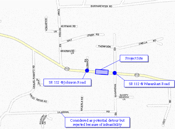
The State Route (SR) 112 Bearcreek Culvert Replacement Project is located in Clallam County in northwest Washington State (see Figure 1). The project site is approximately 11 miles west of the City of Port Angeles, between the intersections of SR 112 with Wasankari Road and Johnson Road (see Figure 2). This section of SR 112 is a two-lane east-west highway primarily providing access to Port Angeles and some of the rural communities along the highway. It is a low-volume rural route with no traffic congestion.
Figure 1. Area Map Showing Relative Location of the Project
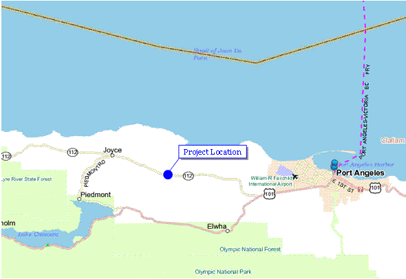
Figure 2. Project Location Map Showing SR 112 between Wasankari Road and Johnson Road
The objective of the project was to remove a passage barrier for migratory fish by replacing the existing culvert. The existing 5-foot by 6-foot concrete box culvert was a barrier to migratory fish passing through Bear Creek. The outfall from the culvert was too high above the stream bed, preventing migratory fish from entering the culvert. As a result of this project, the existing box culvert was removed and replaced with a bottomless precast concrete culvert of 18-foot span. The stream bed was then re-established at a geometry and gradient that would facilitate fish passage.
The key activities performed under this project included grading, constructing a detour, installing a three-sided structure, installing guardrail, placing surfacing and hot mix asphalt, moving existing utilities, seeding, erosion control, and installing traffic items. The project was bid in November 2005 and built in spring 2006. The construction lasted about 35 days at a construction cost of approximately $328,000.
The length of the work zone was 0.07 miles (approximately 370 feet). The road was closed for construction, and a temporary one-lane, one-way diversion (on-site detour) served as the primary traffic management strategy. Traffic was alternated onto this temporary detour with flaggers during work hours. This allowed work vehicles access to the site. Work was performed only during the day, and a temporary traffic signal was used to alternate traffic at night. Both staged construction (with partial road-closure) and the use of an existing roadway as a detour (offsite detour) were considered as potential options, but neither was chosen. Staged construction was rejected because of the potentially high cost of building the culvert one-half at a time by closing one direction of the highway. The offsite detour option was rejected because the detour road was in very poor condition and vehicles larger than passenger cars and light trucks would not be able to negotiate the turns. Overall, the project was very minor and did not have any significant work zone impacts because it was on a rural highway with very low traffic volume – Average Annual Daily Traffic (AADT) of 4,155 vehicles.
2.0 Work Zone Impacts Assessment Process Example
This section discusses how work zone impacts assessment was conducted for the SR 112 project, how decisions were made on what transportation management plan (TMP) strategies to include and implement, and what actions were taken by the Washington State Department of Transportation (WSDOT) to manage the impacts of the project during construction.
The FHWA guide, Work Zone Impacts Assessment: a Process to Manage Work Zone Safety and Mobility Impacts of Road Projects [hereafter referred to as the FHWA Work Zone Impacts Assessment Guide, available at http://ops.fhwa.dot.gov/wz/resources/final_rule.htm (accessed 09/27/06)] provides a systematic process for work zone impacts assessment. It starts at the policy level and progresses through systems planning, preliminary engineering, design, construction, and performance assessment. The following discussion of the SR 112 project is generally structured according to the FHWA impacts assessment guide. The principles in the FHWA guide have been applied to this example, however, owing to the small project size and low traffic volumes, little was required by way of work zone impacts assessment other than identifying the need for a temporary on-site detour and developing an appropriate Temporary Traffic Control (TTC) plan. Therefore, the example discussion is not necessarily broken into all the detailed steps that are provided in the FHWA guide.
2.1 Policy Considerations for the SR 112 Project
According to the WSDOT Work Zone Traffic Control Guidelines [Washington State Department of Transportation, Work Zone Traffic Control Guidelines, January 2006, http://www.wsdot.wa.gov/publications/manuals/fulltext/M54-44/Workzone.pdf (accessed 03/08/07)]:
The primary function of work zone traffic control is to allow vehicles, cyclists, and pedestrians to move safely and easily through or around work areas. Effective temporary traffic control enhances traffic safety and efficiency. Drivers and pedestrians need to be guided in a clear and positive manner while approaching and traversing temporary traffic control zones.
WSDOT uses a combination of standards, policies, and guidelines to manage work zone safety and mobility. The following is a high-level checklist of different aspects that need to be considered/addressed in decision-making on work zone traffic management:
- The duration of work.
- Choosing work hours such that peak periods are avoided. WSDOT regions use different work hour charts to determine the best work hours for a given project (work hour charts are not always needed for all projects).
- Selection of the appropriate traffic control layout(s) based on work duration, type of roadway, traffic volume, and speed.
- Determination of any modifications to typical traffic control layout(s).
- Checking the condition of traffic control devices during construction.
- Installation of devices beginning with the first device the driver will see.
- Conducting work zone drive-throughs to check for problems.
- Documentation of temporary traffic control zone problems and/or major modifications.
- Maintaining traffic control devices while in place.
- Removing traffic control devices as soon as work is completed, beginning with the last device placed.
For the SR 112 project, the overall objective of providing for work zone safety and mobility drove the decision-making on work zone traffic management strategies. In the following sections, policies/guidelines that were applied to the SR 112 project are discussed at appropriate locations.
2.2 SR 112 Work Zone Considerations During Systems Planning
The FHWA Work Zone Impacts Assessment Guide breaks work zone impacts assessment during systems planning into six steps, [more details on these steps are available in Chapter 4, Section 4.5, Assessment Process, of the FHWA Work Zone Impacts Assessment Guide, available at http://ops.fhwa.dot.gov/wz/resources/final_rule.htm (accessed 09/27/06)] which are as follows:
- Compile Project/Work Zone Scope Information for the Alternatives;
- Assess Work Zone Impacts of Alternatives at a Screening Level;
- Analyze Potential Impacts (Optional);
- Identify Potential Work Zone Management Strategies;
- Perform Plan/Program-Level Work Zone Impacts Assessment; and
- Compile Planning-Level Work Zone Strategy.
Because the SR 112 project was minor, the above activities were not necessarily broken into separate steps, rather they were conducted in tandem. As part of the project scoping process, WSDOT prepares a project summary report (PSR) for all projects. The PSR defines the project and the specific work to be performed and provides a preliminary cost estimate for the project. The PSR also identifies potential issues that need to be accounted for (e.g., environmental impacts, utility relocation, and work zone mitigation).
For the SR 112 project, the PSR noted that the purpose of the project was to remove the migratory fish passage barrier by replacing the existing 5-foot by 6-foot concrete box culvert with a bottomless precast concrete culvert of 18-foot span. The total cost was estimated at $560,392, with $150,000 for preliminary engineering, $28,500 for right-of-way (ROW) and $381,892 for construction. The following additional aspects were documented in the PSR:
- Environmental Considerations – The PSR documented that any in water work must be performed within the Washington Department of Fish and Wildlife (WDFW) specified work window.
- Design Decisions – This element in the PSR documents any design level, geometric, geotechnical, hydraulic, structural, or pavement design decisions made to date. The PSR documented that since this was not a National Highway System (NHS) route, there were no significant design issues that needed to be considered through a design matrix. The PSR also noted that the design elements would be evaluated with respect to the modified design level.
- Public Input/Involvement – The PSR noted that there had not been any public involvement to date, and that future public involvement would include articles in newspapers, and mailings to local residents.
- Potential Utility Impacts – The PSR noted that there were water lines (Crescent Water Association) and buried telephone lines (Qwest communications) that would need to be relocated to accommodate the new culvert and the associated stream gradient.
- Work Zone Traffic Control Strategy – Every PSR prepared by WSDOT generally has a separate addendum for the work zone traffic control strategy. The size of the addendum varies according to the project size and expected work zone impacts. In the case of the SR 112 project, the addendum was a small paragraph describing the proposed strategy. The PSR noted that an alternating one-way lane would be constructed along the south side of the project for the traveling public. During work hours, traffic would be controlled by a flagger, and during nonwork hours a temporary traffic signal would be in operation. A flagging scheme was chosen for traffic control during work hours because of the flexibility of adjusting the traffic control according to the work being performed. During nonwork hours, there would not be a need to adjust the traffic control, so a temporary traffic signal operating on a preset scheme would suffice. The PSR also identified the need for temporary illumination to provide lighting for the road closure and the on-site detour. This was particularly important to ensure safety because of the rural location of the project. After the new structure was completed, traffic would be routed over the new structure, the detour would be removed, and guardrail would be installed. During the construction of the detour, one-lane, two-way taper lane closures would be used on SR 112. The same closure scheme would be used for guardrail installation, which would be performed after the removal of the detour.
- Other Issues (Emergency Services, School, Transit, etc.) – The PSR identified the need to coordinate traffic control with local schools, transit, and emergency services.
- Traffic Counts – The PSR included daily traffic counts conducted at the intersection of SR 112 and Wasankari Road. The bidirectional annual average daily traffic (AADT) was determined to be 4,155 vehicles. The highest peak-hour volume was determined to be 292 vehicles (bidirectional), occurring during the afternoon peak period. This indicated that the traffic volume was significantly low.
Note: This stage in systems planning, when potential improvement alternatives are evaluated, is a good point to assess whether a project will be a significant project. At the time that the SR 112 project was planned, WSDOT did not yet have a formal definition for "significant project." However, based on past experience and engineering judgment, an assertion was made that the project would not have significant work zone impacts. [Section 630.1010 of the Work Zone Safety and Mobility Rule provides a definition for "significant projects." Significant projects are used to stratify TMPs according to the expected work zone impacts of projects. As per the Rule, a TMP must always consist of a temporary traffic control (TTC) plan, and for significant projects, it must also address Transportation Operations (TO) and Public Information (PI) components. More information on the Rule and significant projects is available at http://ops.fhwa.dot.gov/wz/resources/final_rule.htm (accessed 09/27/06)]
2.3 SR 112 Work Zone Considerations During Preliminary Engineering
The FHWA Work Zone Impacts Assessment Guide breaks work zone impacts assessment during preliminary engineering into seven steps, which are as follows [more details on these steps are available in Chapter 5, Section 5.4, Assessment Process, of the work zone impacts assessment guide, available at http://ops.fhwa.dot.gov/wz/resources/final_rule.htm (accessed 09/27/06)]:
- Compile Project Information;
- Reassess Project Definition;
- Develop Candidate Construction Approaches;
- Perform Preliminary Work Zone Impacts Assessment;
- Analyze Potential Impacts (Optional);
- Identify Preliminary Work Zone Management Strategies; and
- Compile Preliminary Work Zone Strategy.
Because the SR 112 project was minor, the above activities were not necessarily broken into separate steps, rather they were conducted in tandem. There was also significant overlap between systems planning and preliminary engineering for the SR 112 project.
The information from the PSR was used as a basis for further investigation during preliminary engineering. For the most part, all the decisions made in the PSR were upheld in the preliminary engineering analysis. The following work zone traffic control options were considered:
- Road Closure with Temporary On-Site Detour – This option was already identified in the PSR and the WSDOT ultimately decided to proceed with this option of closing the roadway and alternating traffic onto a temporary on-site detour. The traffic volume on SR 112 was so low that WSDOT decided not to perform even a basic capacity analysis. The WSDOT volume threshold for flagging is 600 to 800 vehicles per hour (vph), whereas, the project volume was only was only 292 vph even during the worst peak hour (p.m. peak). As a result, WSDOT did not perform any work hour restrictions analysis either, allowing work to proceed during normal daytime hours. [Though SR 112 was closed for construction, the temporary detour was an on-site detour, and if the traffic volume had exceeded the capacity of the on-site detour significantly, WSDOT would have had to consider restricting the working hours for the project.]
- Road Closure with Existing Roadway as a Detour (Offsite Detour) – Liljedahl Road was considered as a local road detour option for the SR 112 project (see Figure 2). It would have been a minimal mileage detour (i.e., would not require motorists to travel a significant extra distance to use the detour). However, Liljedahl Road was in very poor condition and vehicles larger than passenger vehicles and light trucks would not be able to negotiate the turns on that road. WSDOT considered providing this detour for cars while directing larger vehicles to the SR 113 and U.S. 101 (see Figure 1). However, it was determined that this option would be too complicated to implement.
- Staged Construction with Unidirectional Lane-Closures (Partial Width Construction) – This third option was considered as a remote possibility. It would have involved constructing the new culvert one-half at a time, by closing one direction of travel and alternating traffic through the open lane. However, based on engineering judgment and past experience, it was determined that this option would be more time-consuming and expensive than the on-site detour. Though a formal comparison was not made, WSDOT engineers believed that the partial width construction could have increased the cost of the project by one-and-a-half to two times that of the on-site detour option. The higher cost would be a result of additional equipment and workers needed for partial width construction. Designing and building the partial width option would have also increased the total project time, although WSDOT did not estimate by how much. Finally, the partial width option would have potentially had higher safety risks because of the proximity of workers to live traffic. Therefore, this option was rejected.
2.4 SR 112 Work Zone Considerations During Design
The FHWA Work Zone Impacts Assessment Guide breaks work zone impacts assessment during design into five steps, which are as follows [more details on these steps are available in Chapter 6, Section 6.4, Assessing Work Zone Impacts During Design, of the work zone impacts assessment guide, available at http://ops.fhwa.dot.gov/wz/resources/final_rule.htm (accessed 09/27/06)]:
- Compile Preliminary Engineering Material;
- Reassess Work Zone Impacts;
- Analyze Work Zone Impacts (As Needed);
- Develop/Recommend Final Construction Staging and TMP; and
- Advertise and Award Contract.
Most of the design-related decisions were already made during preliminary engineering and all the previously made decisions were upheld during design. The work zone speed limit was finalized during design. The prevailing speed limit on SR 112 was 55 mph, which was brought down to 20 mph for the work zone. This reduced speed limit would provide for safe travel through the on-site detour. The reduced speed limit was not expected to contribute to any significant delays because of the extremely low traffic volume. The final Plans, Specifications, and Estimates (PS&Es) were then developed and the contract was bid, with the contract being awarded to the lowest bidder at approximately $328,000.
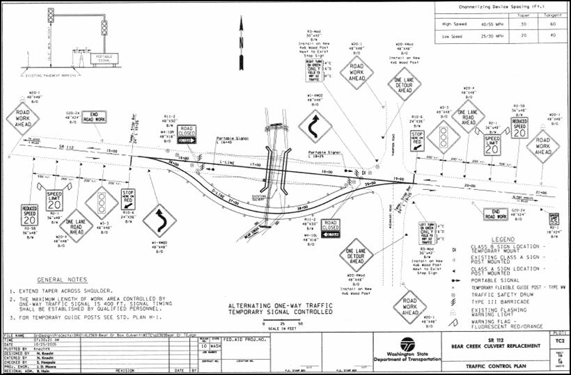
Figure 3 shows the TTC plan used for the flagging operation during work hours, and Figure 4 shows the TTC plan used for the temporary traffic signal used for nonwork hours.
Figure 3. TTC Plan used for Flagging Operation During Work Hours
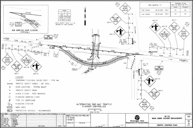
Figure 4. TTC Plan used for Temporary Traffic Signal Operation During Nonwork Hours
2.5 SR 112 Work Zone Impacts Management During Construction
The FHWA Work Zone Impacts Assessment Guide breaks work zone impacts management during construction into seven steps, which are [more details on these steps are available in Chapter 7, Section 7.4, Managing Work Zone Impacts During Construction, of the work zone impacts assessment guide, available at http://ops.fhwa.dot.gov/wz/resources/final_rule.htm (accessed 09/27/06)]:
- Coordinate Preconstruction Activities;
- Review Contractor's Alternate Approach (As Needed);
- Reassess Anticipated Work Zone Impacts (Revise TMP, if necessary);
- Implement TMP;
- Monitor Work Zone Safety and Mobility Impacts During Construction;
- Assess Compliance with Performance Criteria; and
- Document Work Zone Performance Findings.
Since the SR 112 project was straightforward and simple, preconstruction coordination was not significant, and there was no need for either an alternate approach or reassessment of anticipated work zone impacts.
During construction, the WSDOT field office monitored the work zone and reported back to the region that there were no safety or mobility problems related to the project. The project lasted a total of 35 days, and in spite of the drastic speed reduction from 55 mph to 20 mph, the work zone traffic delay was minimal because the traffic volume was very low.
2.6 SR 112 Performance Assessment
The normal WSDOT practice is to try and engage the project designers in reviewing the work zone in the field. However, this was not necessary in the case of the SR 112 project because there were no significant issues to address or take note of. No specific actions were taken to document the work zone performance issues for the SR 112 project. This was because no significant issues were encountered during the project.
previous