Work Zone Impacts Assessment:
Example Work Zone Impacts Assessment for a Minor/Basic Project: North Carolina Department of Transportation, SR 1728 (Middle Road), Bridge Replacement Project
March 30, 2007
Acknowledgments
The project team is grateful to the North Carolina Department of Transportation (NCDOT) for committing their time and effort towards the success of this example project write-up. Comprehensive work zone impacts assessment for road construction is an emerging area, and the Federal Highway Administration (FHWA) would like to thank the NCDOT for sharing their insights and practices on this very relevant topic.
Specifically, we would like to express our gratitude to Mr. Steve Kite, P.E., of the NCDOT, Work Zone Traffic Control Unit. Mr. Kite served as the primary liaison between the project team and NCDOT, and provided us extensive information on the SR 1728 project, participated in several phone calls, and also obtained additional information on request. His overall understanding and knowledge about the SR 1728 project, timely contributions, and willingness to further the practice of work zone transportation management were keys to the successful completion of this case study.
1.0 Project Overview
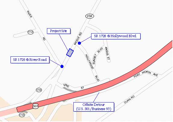
The State Route (SR) 1728 Bridge Replacement Project is located in Cumberland County in the vicinity of Fayetteville, North Carolina, approximately 60 miles south of Raleigh (see Figure 1). The project site is located between River Road and Hollywood Boulevard (see Figure 2). This section of SR 1728, which is also called Middle Road, is a two-lane highway providing access to parts of East Fayetteville and rural communities northeast of Fayetteville. It is a low-volume road with an Average Daily Traffic (ADT) of 5,400 vehicles. The objective of this 2006-2007 project was to replace an old and deteriorating bridge structure of 104-foot span over Gum Log Creek, with a new bridge of 120-foot span.
Figure 1.Area Map Showing Relative Location of the Project
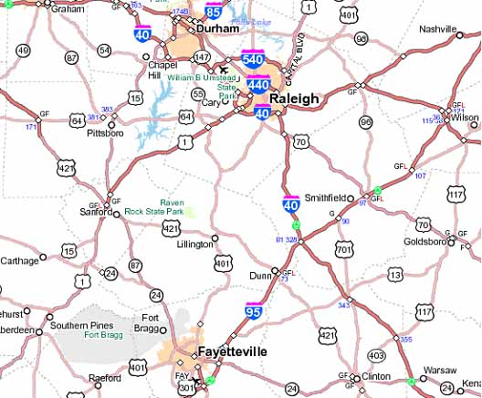
Figure 2.Project Location Map Showing SR 1728 between River Road and Hollywood Boulevard
The work zone traffic control strategy was to close SR 1728 for about 300 feet between River Road and Hollywood Boulevard, and reroute traffic to an existing roadway, U.S. 301/I-95 (Business Route). The key activities performed under this project included installing off-site detour signage, closing SR 1728 for construction, removal of the existing bridge structure, and construction of the new bridge. Flaggers were used for traffic control during transition periods (e.g., during road closure implementation). The project was let in August 2006 and construction started on February 26, 2007. The project duration is expected to be about 135 working days at a construction cost of $723,274.
The only other alternative work zone approach identified for this project was to stage construct the bridge one-half at a time by closing one direction of the highway. However it was not necessary to significantly evaluate this alternative approach. For a project as straightforward as this, with low traffic volumes and a convenient detour route, stage construction would only have complicated matters, dramatically increasing both the cost and the environmental footprint.
2.0 Work Zone Impacts Assessment Process Example
This section discusses how work zone impacts assessment was conducted for the SR 1728 project, how decisions were made on what transportation management plan (TMP) strategies to include and implement, and what actions were taken by the North Carolina Department of Transportation (NCDOT) to manage the impacts of the project during construction.
The FHWA guide, Work Zone Impacts Assessment: A Process To Manage Work Zone Safety and Mobility Impacts of Road Projects [hereafter referred to as the FHWA Work Zone Impacts Assessment Guide, available at http://ops.fhwa.dot.gov/wz/resources/final_rule.htm (accessed 09/27/06)], provides a systematic process for work zone impacts assessment. It starts at the policy level and progresses through systems planning, preliminary engineering, design, construction, and performance assessment. The following discussion of the SR 1728 project is generally structured according to the FHWA impacts assessment guide. The principles in the FHWA guide have been applied to this example, however, owing to the small project size and low traffic volumes, little was required by way of work zone impacts assessment other than identifying the need for the road closure and detour and developing an appropriate Temporary Traffic Control (TTC) plan. Therefore, the example discussion is not necessarily broken into all the detailed steps that are provided in the FHWA guide.
2.1 Policy Considerations for the SR 1728 Project
According to the NCDOT's Draft Work Zone Safety and Mobility Policy and Procedures [North Carolina Department of Transportation, Work Zone Safety and Mobility Policy and Procedures, Draft December 5, 2006, available at http://www.ncdot.org/doh/preconstruct/wztc/final%20rule/ImportantDocs/WZSafetyandMobilityDraftPolicy06_12_05.pdf]:
The North Carolina Department of Transportation applies comprehensive transportation management strategies throughout the planning and project development process, purposefully provides safe and efficient projects, and uses innovative techniques in design, contracting methods, and construction to minimize impacts, crashes, and delays.
NCDOT procedures for project evaluation during planning, design, and construction and requirements for Transportation Management Plans (TMPs) depend on the following criteria:
- Existing AADT (may also use the AADT anticipated when the work zone will be in place);
- Total Truck Traffic;
- Duration of Construction;
- User Value and User Cost;
- Anticipated Additional Travel Times;
- Anticipated Impacts to the Existing Transportation Infrastructure/Network; and
- Anticipated Impacts to High Traffic Volume Generators.
At NCDOT, user value and user cost are important considerations in decision-making for work zone traffic management. User value refers to the value of the completed project in improving the quality of travel through the facility. If a project is expected to significantly improve travel quality (e.g., eliminate heavy traffic congestion), NCDOT may choose to expedite the completion of such a project by reducing the construction duration. Consequently, work zone management strategies, such as full road closures, that allow reduced construction duration are chosen. In such cases, a tradeoff is made between the severity and duration of the work zone impacts, and the ultimate value of the finished project.
User cost or road user cost (RUC) is used by the NCDOT as a surrogate to represent the potential mobility impact of a road construction project. RUC is calculated for all projects, regardless of project size and complexity. RUC is used as a tool to help reinforce traffic control requirements by establishing appropriate liquidated damages for compliance with lane closure restrictions and project completion dates. RUC is also used in decision-making for accelerated construction techniques such as A+B bidding. In the case of full road closures, the RUC calculation is performed for the detour road and represents the increased cost of traversing the detour as opposed to the original road.
For the SR 1728 project, decision-making on work zone traffic control was based on the overall goal of providing for a safe and efficient work zone. Policies and guidelines (including RUC) that were applied to the SR 1728 project are discussed at appropriate locations in the following sections.
2.2 SR 1728 Work Zone Considerations During Systems Planning
The FHWA Work Zone Impacts Assessment Guide breaks work zone impacts assessment during systems planning into six steps, which are as follows [more details on these steps are available in Chapter 4, Section 4.5, "Assessment Process," of the FHWA Work Zone Impacts Assessment Guide, available at http://ops.fhwa.dot.gov/wz/resources/final_rule.htm (accessed 09/27/06)]:
- Compile Project/Work Zone Scope Information for the Alternatives;
- Assess Work Zone Impacts of Alternatives at a Screening Level;
- Analyze Potential Impacts (Optional);
- Identify Potential Work Zone Management Strategies;
- Perform Plan/Program-Level Work Zone Impacts Assessment; and
- Compile Planning-Level Work Zone Strategy.
Because the traffic impacts of the SR 1728 project were minor, the above activities were not necessarily broken into separate steps; rather they were conducted in tandem.
The NCDOT administrative structure is centralized and most planning and environmental functions are performed at their headquarters in Raleigh. When a project is introduced into the Transportation Improvement Program (TIP), planners start conducting early investigations and assessments to identify the factors that will influence the implementation of the project. To begin with, they identify alternative methods to satisfy the project need (e.g., repairing an existing structure versus rebuilding it). The improvement alternatives are then assessed to identify the alternative that best serves the need with the least cost and the least impact (e.g., environmental, work zone). This assessment is primarily done by planning staff, but they seek input from design, construction, and traffic engineers as appropriate. In the case of minor/basic projects, planners are able to make most of the decisions, which are then carried through to preliminary engineering and final design. However, major and more complicated projects required extensive consultation with and participation by staff from other disciplines.
For most projects, planners, designers, construction engineers, and traffic engineers convene a scoping meeting to share ideas and assess alternatives. Since RUC analysis is required for all projects, sometimes the RUC process may be initiated and completed during the early planning stages of a project, depending upon the availability of information. Information from the planning stage is then forwarded to the NCDOT Division responsible for each project. Engineers at the respective Divisions make the final decisions for their projects based on initial recommendations from the planning stage.
For the SR 1728 project, a brief scoping report was prepared as part of the environmental process to seek a Categorical Exclusion (CE) [categorical Exclusion (CE) as defined by the National Environmental Policy Act (NEPA). This scoping report presented two different build alternatives and one no-build alternative. Alternate 1 was recommended as the preferred alternative. The following is a summary of information contained in the scoping report:
- Build Alternate 1 (preferred) would replace the existing 104-foot structure with a new structure in the same location. Traffic would be maintained with an off-site detour on an existing road – U.S. 301/I-95 (Business Route). In addition to the primary detour route, parts of SR 1720, SR 1725, and SR 1728 would also constitute the detour route. The total cost of this alternative was estimated to be approximately $1.2 million, including costs for project development, right-of-way (ROW), and construction. In addition to having a lower construction cost, this alternative would result in fewer impacts to streams and better horizontal alignment for the new bridge. The Division Engineer from NCDOT Division 6 concurred with the preferred alternative and the off-site detour route.
- Build Alternate 2 (eliminated) would replace the existing bridge with a new structure approximately 20 feet upstream of the existing location. This approach would require staged construction with traffic being maintained on the existing structure during construction. The total cost of this alternative was estimated to be approximately $1.7 million, including costs for project development, ROW, and construction. In addition to being more expensive, this alternative would result in a bigger environmental footprint as it would take much longer to stage-construct the bridge as compared to closing it down for construction.
- No Action Alternate (eliminated) would eventually necessitate removal of the bridge because investigation of the structure by the NCDOT Bridge Maintenance Unit indicated that rehabilitation of the old bridge would not be feasible due to its age and deteriorated condition.
A scoping meeting was then convened between planners and engineers from NCDOT headquarters, and appropriate personnel from NCDOT Division 6. A decision was made at this scoping meeting to proceed with Alternate 1 to rebuild a new bridge at the existing location and use an off-site detour during construction. As part of the planning process, emergency response routing and access issues were also considered in decision-making to close the roadway for construction. A review of the detour route indicated that the road closure would not have any significant effect on emergency response routing and access, and that emergency response vehicles would not experience delays as a result of the construction project.
Note: This stage where a preliminary assessment of improvement alternatives is performed is a good point to assess whether a project will be a significant project. [Section 630.1010 of the Work Zone Safety and Mobility Rule provides a definition for "significant projects." Significant projects are used to stratify TMPs according to the expected work zone impacts of projects. As per the Rule, a TMP must always consist of a temporary traffic control (TTC) plan, and for significant projects, it must also address Transportation Operations (TO) and Public Information (PI) components. More information on the Rule and significant projects is available at http://ops.fhwa.dot.gov/wz/resources/final_rule.htm (accessed 09/27/06).] At the time that the SR 1728 project was planned, NCDOT did not yet have a formal definition for "significant project." However, based on past experience and engineering judgment, an assertion was made that the project would not have significant work zone impacts.
2.3 SR 1728 Work Zone Considerations During Preliminary Engineering
The FHWA Work Zone Impacts Assessment Guide breaks work zone impacts assessment during preliminary engineering into seven steps, which are as follows [more details on these steps are available in Chapter 5, Section 5.4, "Assessment Process," of the FHWA Work Zone Impacts Assessment Guide, available at http://ops.fhwa.dot.gov/wz/resources/final_rule.htm (accessed 09/27/06)]:
- Compile Project Information;
- Reassess Project Definition;
- Develop Candidate Construction Approaches;
- Perform Preliminary Work Zone Impacts Assessment;
- Analyze Potential Impacts (Optional);
- Identify Preliminary Work Zone Management Strategies; and
- Compile Preliminary Work Zone Strategy.
Because the traffic impacts of the SR 1728 project were minor, the above activities were not necessarily broken into separate steps; rather they were conducted in tandem. Further, there was significant overlap between systems planning and preliminary engineering, whereby, some of the preliminary engineering tasks had already been accomplished during planning.
At this stage of the SR 1728 project, preliminary design and traffic control planning activities were started based on information developed during planning. Since most of the key decisions were already made during planning, the objective during preliminary engineering was to verify the assumptions and decisions made during planning, and to further investigate the viability of the recommended traffic control approach for the project. The key preliminary engineering activity was to estimate the RUC. As stated before, RUC is used by the NCDOT as a surrogate to represent the potential mobility impact of a project, and is calculated for all projects irrespective of project size and complexity.
RUC estimation at NCDOT is a simple volume to capacity analysis using three different in-house spreadsheet programs. The objective of the analysis is to produce an order-of-magnitude estimate, rather than a detailed analysis. RUC is based on traffic delay due to the project and consists of the following components:
- Detour Delay;
- Delay Associated with Flagging Operations; and
- Delay Associated with Lane Closures.
Further, RUC values produced by the spreadsheet programs are pro-rated to ensure reality and practicality of enforcement. For example, RUC is used to establish appropriate liquidated damages if contractors violate work hour restrictions. In order for contractors to consider the penalty seriously, the minimum RUC value needs to be high enough such that contractors are unwilling to assume that financial risk. The NCDOT sets this minimum contract liquidated damage at $500 per hour. Similarly, there needs to be an upper limit for penalties applied to contractors lest they refrain from bidding on NCDOT projects. An upper limit on liquidated damages also discourages contractors from submitting inflated project bids that could potentially be rejected. This upper limit is $10,000 per hour, and is generally used for major projects expected to have very significant impacts, and also for projects that have sensitive regional and sociopolitical implications.
The SR 1728 project involved a full road closure with an off-site detour. So there was a detour delay component to the RUC. However, the other two aspects (i.e., flagging operations and lane closures) were not a part of this project, and therefore did not constitute any part of the RUC. The detour RUC is a function of total ADT, percentage of trucks, truck ADT, car ADT, speed limit, original length, detour length, the number of turns associated with the detour, and the number of expected stops associated with the detour. Using the in-house spreadsheets, NCDOT calculates the delay for vehicles to travel the extra distance on the detour, which is then monetized into a representative Dollar Value. Truck delay costs are monetized at $18.50 per hour and car delay costs at $9.10 per hour. The additional operating cost for traveling the detour route is also calculated. The operating and delay costs are then added to obtain the total RUC. The RUC for the SR 1728 project was estimated at $3,509.62 per day, resulting in the choice of an accelerated construction technique to lessen the impact to the motoring public using the detour. After evaluation, NCDOT decided to use A+B bidding to reduce the construction time. NCDOT asked bidders to provide a Dollar Value (the A part) and duration not to exceed 170 days (the B part). The winning bid came in at a construction cost of $723,274 (Part A) and a duration of 135 days (Part B). In addition, NCDOT placed a liquidated damage of $1,000 per day for late completion after the 135th day. The original NCDOT engineer's estimate was 180 days, while the contract was let with a duration of 135 days, thus saving 45 days of RUC impact valued at about $157,933.
In addition to delay and the associated RUC, the following overriding considerations apply in determining whether an offsite detour would be allowable for a project:
- Emergency Medical Services (EMS) Considerations - If the county EMS coordinator expresses and maintains a strong opposition to an offsite detour, citing high risk of loss of human life, this factor outweighs all other considerations resulting in maintaining traffic on-site. If EMS states a moderate or low concern, other factors will be considered in the analysis. In the case of the SR 1728 project, EMS concerns were low and did not pose an impediment to the offsite detour.
- Condition of the Offsite Detour Route - A route may not be closed for construction unless the condition, safety, geometry, and traffic handling capacity of the offsite detour are acceptable or can be improved to an acceptable level. In the case of the SR 1728 project, the condition of the offsite detour route was determined to be acceptable.
- Bridges on the Offsite Detour Route - If the condition and/or geometry of any bridges on the offsite detour are not as good as or better than the bridge being replaced, a determination must be made whether permanent or temporary improvements can be made to the bridge(s) on the offsite detour. For the SR 1728 project, bridges on the offsite detour were not a concern.
- Improvements to the Offsite Detour - If it is determined that improvements are required on the offsite detour, those improvements need to be evaluated as part of the National Environmental Policy Act (NEPA) document, and included in decision-making for the offsite detour. For the SR 1728 project, no improvements were needed to the offsite detour and this was not an issue of concern.
- Jeopardy Opinion - A jeopardy opinion from the United States Fish and Wildlife Service (USFWS), that is, potential jeopardy to fish and wildlife, could outweigh the delay considerations for the offsite detour. For the SR 1728 project, this was not an issue.
- Other Considerations - Other factors such as high traffic volumes on the detour, at-grade railroad crossings, or frequent flooding also influence the decision-making. None of these issues were encountered on the SR 1728 project.
2.4 SR 1728 Work Zone Considerations During Design
The FHWA Work Zone Impacts Assessment Guide breaks work zone impacts assessment during design into five steps, which are as follows [more details on these steps are available in Chapter 6, Section 6.4, "Assessing Work Zone Impacts During Design," of the FHWA Work Zone Impacts Assessment Guide, available at http://ops.fhwa.dot.gov/wz/resources/final_rule.htm (accessed 09/27/06)]:
- Compile Preliminary Engineering Material;
- Reassess Work Zone Impacts;
- Analyze Work Zone Impacts (As Needed);
- Develop/Recommend Final Construction Staging and TMP; and
- Advertise and Award Contract.
For the SR 1728 project, most of the design-related decisions were already made during preliminary engineering and all the previous decisions were upheld during design. The NCDOT roadway design unit assumes responsibility for the project after the planning and preliminary engineering stages.
Section 1101-70, "Temporary Road Closures" of the NCDOT design specifications provides guidelines for traffic control decisions associated with temporary road closures. The following apply:
- Traffic Pattern Alterations. When a traffic pattern is altered from the usual or expected flow, such as during road closures or while stopping traffic, notify the Engineer 21 calendar days (or as specified in the plans) prior to altering the traffic pattern. Pre-plan all traffic pattern alterations. Hold a meeting with the Engineer before altering traffic to discuss the necessary details of implementation. The Engineer, as necessary, will then notify the proper authorities, such as police, emergency personnel, business owners, residents, or any other parties that will be affected by traffic being redirected from its normal flow.
- Detour. Ensure that all required detour signing and delineation, including work done by others, are in place prior to placing traffic onto a detour.
- Traffic Stoppage. Limit stopping traffic to times specified in the plans. Provide enough time between consecutive stoppages to allow traffic to return to normal flow.
The final Plans, Specifications, and Estimates (PS&Es) were then developed (based on the previously established decisions) and the contract was bid, with the contract being awarded to the lowest bidder at a construction cost of $723,274 and duration of 135 days. The TTC Plan specified the following additional provisions:
- Pavement edge drop off requirements;
- Traffic pattern alterations requirements to notify the engineer 21 calendar days prior to any traffic pattern alteration; and
- Phasing requirements, specifying that the project would be conducted in three sequential steps – the first to install the off-site detour signage and then closing SR 1728; the second step to remove the existing structure and construct the new structure; and the third to open the new road followed by removal of the detour signage.
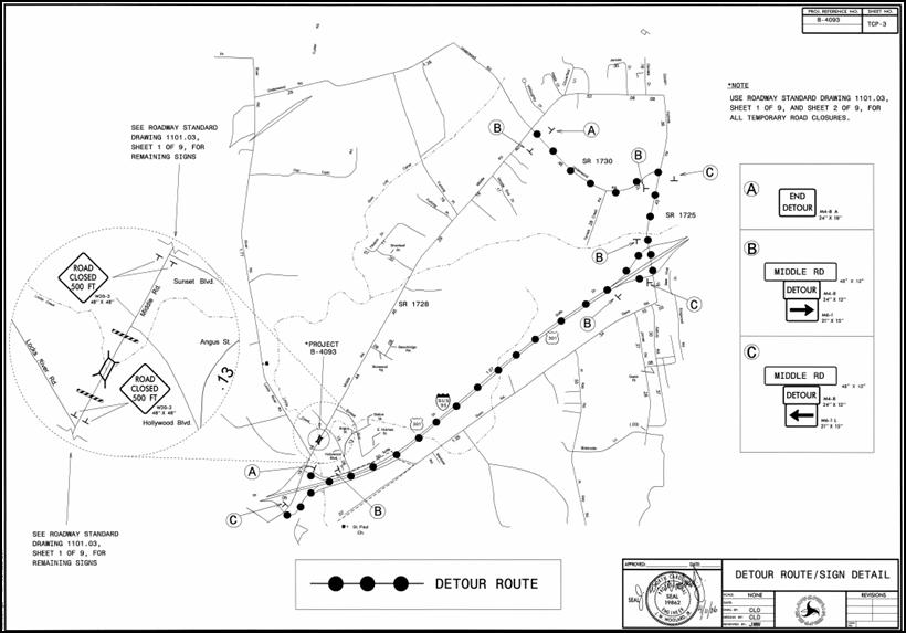
Figure 3 shows the detour plan used for the project. The detour route was primarily intended for through traffic because NCDOT expected local traffic on SR 1728 to already be familiar with the road closure and possible alternate routes. Therefore, they did not use extensive detour signage on SR 1728, other than "Road Closed" signs placed 500 feet in advance of the road closure.
Figure 3. SR 1728 Project Detour Plan
2.5 SR 1728 Work Zone Impacts Management During Construction
The FHWA Work Zone Impacts Assessment Guide breaks work zone impacts management during construction into seven steps, which are [more details on these steps are available in Chapter 7, Section 7.4, "Managing Work Zone Impacts During Construction," of the FHWA Work Zone Impacts Assessment Guide, available at http://ops.fhwa.dot.gov/wz/resources/final_rule.htm (accessed 09/27/06)]:
- Coordinate Preconstruction Activities;
- Review Contractor's Alternate Approach (As needed);
- Reassess Anticipated Work Zone Impacts (Revise TMP, if necessary);
- Implement TMP;
- Monitor Work Zone Safety and Mobility Impacts during Construction;
- Assess Compliance with Performance Criteria; and
- Document Work Zone Performance Findings.
Since the SR 1728 project was straightforward, preconstruction coordination was not significant, and there was no need for either an alternate approach or reassessment of anticipated work zone impacts.
At NCDOT, during construction, the resident engineer (RE) monitors projects and reports back to headquarters traffic control personnel if project conditions turn out to be significantly different than anticipated. On small projects, there is usually no need to measure impacts. On bigger projects, traffic volumes and speeds are monitored on an as needed basis. The construction inspector also performs informal traffic mobility and safety monitoring. The SR 1728 project is currently under construction, and so far, no significant delay or safety impacts have been encountered.
2.6 SR 1728 Performance Assessment
The project is still under construction as of the writing of this impacts assessment example. No specific actions are being undertaken to document work zone performance findings because no significant issues have been encountered during the project to date.
previous