I-35 Hillsboro, Texas
In October 2006, The Texas Department of Transportation (TXDOT) implemented an ITS system in a construction work zone in Hillsboro, Texas. The purpose of the system was to monitor conditions and improve mobility and safety through the work zone along I-35, 35W, and 35E in Hillsboro County. TXDOT designed the system to provide motorists with real-time information on downstream conditions and to provide alternate route guidance during times of heavy mainline congestion. TXDOT sought to warn motorists of speed variability issues and to lessen traffic delays caused by capacity reductions and rubber-necking in the work zone.
TXDOT designed an ITS system for a work zone on Interstate 35 south of Waco in Hillsboro County, as shown in Figure 5.
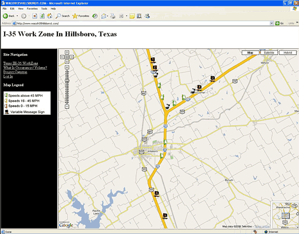
Figure 5. I-35 Work Zone and Signed Alternate Routes (Taken from TXDOT's Web Site)
Based on predetermined speed and occupancy thresholds, the system provided real-time delay information and recommended alternate routes via dynamic message signs (DMS). TXDOT operators also monitored traffic conditions in the work zone through the use of three wireless closed circuit video cameras.
The main objectives of the system were to:
- Reduce demand and congestion (by actively diverting traffic approaching the work zone).
- Provide delay information and route guidance to motorists enroute to warn them of slowed traffic ahead.
- Provide trip planning information to commuters and system management information to DOT personnel via a Web site.
The main objectives of the evaluation were to:
- Determine traveler response to the work zone information.
- Determine the effect of traveler response on traffic conditions.
- Determine whether the system detected congestion as it occurred and posted the appropriate messages.
Study Site Work Zone
TXDOT installed the work zone between milepost (MP) 364 and MP 374, north of Waco. As shown in Figure 17, I-35 splits north of Waco into I-35E leading to Dallas and I-35W leading to Fort Worth. All three highways have similar characteristics and are four-lane divided freeway facilities. TXDOT set up lane closures in each direction in order to reconstruct the main interchange and rehabilitate and reconstruct pavement and structures along the route.
The contractor began construction in July 2006 with an estimate for completion of mid-2008. Two separate construction projects were planned for the general area. Lane closures on the south end of the corridor near exit 364 occurred from October 2006 through February 2007. For the second project, the contractor restricted capacity by closing one lane in each direction during late 2006 and early 2007. The latter project is located on I-35 at the I-35E / I-35W interchange near milepost 371. Work will continue through 2008.
TXDOT expected long queues and delays, especially on I-35W southbound near the split. For northbound I-35, the existing geometry is such that each lane directs traffic to either I-35E or I-35W. That is, the two lane section splits into one lane for I-35E traffic and another separated lane for I-35W traffic. I-35 branches off into two directions to the north and becomes I-35E and I-35W. A large portion of the traffic along the corridor is commuter traffic, as many of the exits along the work zone area serve farm land and provide access from rural roads. Major attractors that might impact traffic patterns were not prevalent along the corridor, especially around exits that are in close proximity to the work zone.
ITS Description
The TXDOT deployment work zone ITS was made up of three individual systems meant to alleviate non-recurring congestion along the I-35 corridor. Since the I-35 roadway configuration consisted of three different approaches to the work zone, three independent traffic monitoring systems were used. Alternate routes were signed for each of the three traffic flows. While one vendor provided the entire system, it acted as three independent closed loop systems, one for each approach to the work zone. While this document may reference the "system," it refers to the entire vendor-provided solution made up of three components.
The primary goal of the system was to monitor this project's work zones and automatically provide alternate route advisory information to the traveling public based on significant travel times through the work zone. A secondary goal of the system was congestion management of non-recurring traffic conditions because of high traffic volumes, weather, and incidents.
The system consisted of the following components:
- Six solar powered portable side-fire microwave detection trailers
- Six solar-powered portable changeable message signs
- Three portable video (camera) trailers
- A system server, Web host, and associated communication equipment and software
- A Web site for use by TXDOT and the general public.
For each approach to the work area, two sensors monitored traffic and sent messages to two PCMS based on pre-determined speed and occupancy thresholds, as shown in Table 5.
| Normal Traffic Flow through Work Zone >=55MPH | Speed Average 40<x>55MPH @5min Lane Occ>20% | Speed Average 25<x>40MPH @5min Lane Occ>30% | Speed Average 10<x>25MPH @5min Lane Occ>40% | Speed Below 10MPH @5min Lane Occ>50% |
|---|---|---|---|---|
| WORKZONE AHEAD 2 MILES NO DELAYS -x:xxPM- |
WORKZONE AHEAD 2 MILES MODERATE DELAYS -x:xxPM- |
WORKZONE AHEAD 2 MILES EXPECT DELAYS -x:xxPM- |
WORKZONE AHEAD 2 MILES LONG DELAYS -x:xxPM- |
WORKZONE TRAFFIC STOPPED USE ALT ROUTE |
TXDOT dynamically adjusted queue thresholds, had message pre-emption capabilities, and had notification capability to alert appropriate personnel of problems. In addition to the vehicle count, speed, and classification data, streaming video was made available from three portable camera trailers. TXDOT also implemented a public Web site to allow access to current system operational status and to view existing traffic conditions. TXDOT procured the system through the prime construction contractor.
Measures and Metrics
The study team focused traffic data collection efforts on measuring diversion rates at freeway exit ramps to test driver response to the system. To supplement the system detector data, the study team collected data through three additional queue trailers with side-fire radar at three key diversion locations along the corridor that provided access to the signed alternate routes. The study team installed sensors upstream of the work zone and system detectors downstream of the PCMS to collect mainline and ramp volume, speed, and occupancy at each location. Original plans included travel time runs on the mainline and alternate routes. However, data collection in this regard proved too costly and difficult to properly capture conditions during impact periods.
The study team compared baseline data prior to ITS implementation (without ITS) with the period when the system was active (with ITS). The study team collected data from the three supplemental detectors from October 3, 2006, until February 4, 2007, and the vendor archived system detector data beginning October 4, 2006 and message logs beginning October 23, 2006. The system was turned on to traffic on October 26, 2006. Figure 6 shows the location of the three supplemental data collection queue detectors (labeled Q1, Q2, and Q3).
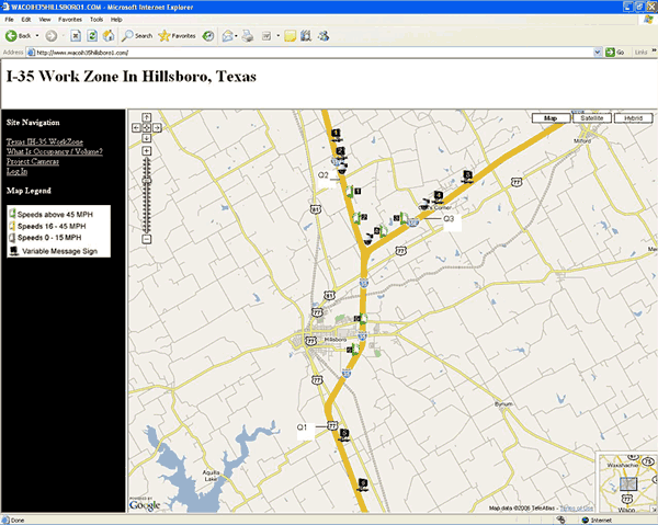
Figure 6. Modified Corridor Map Showing Data Collection Sensor Locations
The success of the evaluation hinged upon the accuracy and completeness of several key data elements, including:
- Traffic volumes and average speed and occupancy measurements at each sensor location.
- Message logs showing the times and dates that the pre-determined messages were activated.
- Time-specific information on construction activities and delay observations as noted by inspectors in DOT construction logs.
The study team developed several hypotheses based on the goals for the system. The key hypothesis, associated measures, and data sources for testing each are shown in the following table.
| Hypothesis | Measures of Effectiveness | Data Sources |
|---|---|---|
| The use of ITS in work zones will divert travelers to alternate routes during times of work zone congestion | Diversion rates at exit ramps with and without the system and with construction; diversion rates during construction or an incident compared with normal patterns | System detector data, supplemental data from three additional queue detectors |
Findings
The study team mainly focused data collection efforts on testing the level of diversion around the work zone during periods of congestion. The site showed that, during times of very heavy congestion, motorists will follow the diversion guidance posted on message boards. Large percentages of traffic diverted on several occasions when the system recommended the alternate route.
For this site, the study team designed the data collection plan to help answer several key questions including:
Question: Did the system detect the congestion as it occurred?
Findings: It appears that the system detected congestion and displayed appropriate messages, although the minimum diversion message post time was likely too short in some cases.
Question: Did the system post appropriate messages when it detected congestion?
Findings: The system posted travel times for conditions at or near free flow travel times, "Slow Traffic Ahead" and similar messages when speeds dropped, and diversion messages when occupancy met the appropriate threshold.
Question: Did motorists respond to the diversion messages—and how?
Findings: When the system posted messages recommending the signed alternate routes, large percentages of traffic diverted. Major incidents during heavy traffic periods (such as holiday weekends) were a main cause for active diversion, more so than typical construction activity and lane closures. During major incidents or high construction impact periods combined with high demand, the system diverted an average of 10 percent of mainline traffic to alternate routes. Diversion was as high as 28 percent during the study observation period.
The key hypothesis was found to be true for this deployment based on observations. The system diverted large amounts of traffic during incident and construction impact periods compared with normal conditions.
The following sections provide additional detail from the analysis.
Construction Activity Information
TXDOT provided construction activity information from inspector logs and from a template provided by the study team. The study team matched the information provided with the data patterns and trends from the data collection period. Tables 7 and 8 highlight the initial information provided by TXDOT.
| Date | Time of Day (Beginning) | Time of Day (End) | Crashes Observed | Mile Marker Location/ Description | Activity Notes |
|---|---|---|---|---|---|
| 10/3/2006 | 8:30 AM | 9:00 AM | Yes | 35W SB mm1 | Three separate crashes – lanes open |
| 10/3/2006 | 9:00 AM | 9:40 AM | Yes | I-35 SB mm 370 | Two vehicle crash – lanes open |
| 10/3/2006 | 8:15 AM | 8:45 AM | Yes | I-35 SB mm 369 | One vehicle crash – lanes open |
| 10/12/2006 | 6:30 PM | 1:30 AM | — | I-35 SB at exit 368B | Inside lane closed for construction |
| Date | Time of Day (Beginning) | Time of Day (End) | Crashes Observed | Mile Marker Location/ Description | Activity Notes |
|---|---|---|---|---|---|
| 11/14/2006 | 9:00 AM | 9:45 AM | Yes | I-35 NB mm 368 | One vehicle involved |
| 11/20/2006 | 7:00 PM | 10:00 PM | I-35 SB mm368B to 370 | Lane closed for pothole repair | |
| 12/13/2006 | 4:30 AM | 11:15 AM | Yes | 35E SB mm372 | Lane closed due to crash and barrier rail repair |
| 12/13/2006 | 4:00 AM | 5:00 AM | — | 35W SB mm2 to mm5 | Lane closed for crack seal work |
| 12/13/2006 | 7:00 PM | 10:00 PM | — | 35W NB | Lane closed for construction activities |
| 12/14/2006 | 3:15 PM | 3:50 PM | Yes | 35W NB at split | Two vehicle crash – lanes open |
| 12/14/2006 | 3:30 PM | 4:00 PM | Yes | I-35 NB US77 Exit Ramp | Three vehicle crash – lanes open |
The study team noted any days where the detectors captured traffic impact periods (any condition other than free flow) but field condition information was not available. TXDOT reviewed its logs and incident database and provided additional information as available. Information was not available for several time periods where traffic data showed delays and queuing.
Several significant incidents and crashes occurred November 23-26, 2006, over the heavily-traveled Thanksgiving Holiday weekend. The traffic data showed significant delay and queuing and heavier than normal volumes. During this time period, the system activated several times to divert traffic. Since the work zone was not active with lane closures and construction activity over the holiday weekend and observations by inspectors were not captured, the study team does not have many of the specific details on the extent of the traffic impacts from the crashes. However, as shown in the following sections, several data points were useful in the analysis.
System Detector Traffic Data
The study team sorted and analyzed traffic data from system detectors and the supplemental data collection detectors to quantify the impacts from construction and to identify periods of impact where additional information would be useful. The archived traffic data from each detector consisted of more than 500,000 records covering a time period from October 2006 through February 2007. Each message consisted of a volume count, an average speed value, and an average occupancy value by lane for both lanes in each direction along I-35, I-35E, and I-35W. The data set for each sensor appeared to be very complete and the data appeared reasonable.
The study team observed one incident during construction and prior to system deployment. A lane closure was in place on October 12 and 13, 2006, on northbound I-35. Figure 7 highlights consistent volume patterns for this baseline time period. The green line (ramp counts) shows no distinct spike in volume based on the conditions. While the study team only had limited observations to analyze during the "without ITS" period, one can logically conclude that motorists (especially through trips) would not be comfortable diverting to an unfamiliar roadway without knowledge of the impact to their trip.

Figure 7. Volume Patterns (Q3: 35E SB) – October 12 Lane Closure (Without ITS)
Figure 8 shows high occupancy values at the system detector location within the work zone between 9 p.m. and 11 p.m. These values showed enough impact to warrant diversion (50 percent occupancy) of traffic during this time period. However, a large percentage of traffic did not divert to the signed alternate routes.
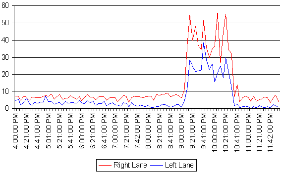
Figure 8. Occupancy Values (System Q4: 35E SB) – October 12 Lane Closure (Without ITS)
The study team also analyzed traffic data during construction and with ITS, mainly focusing on days where the system actively diverted traffic. For a major crash on November 26, 2006, involving a tractor trailer, the data showed higher than normal ramp volumes during a nearly 5 hour period where the system actively diverted traffic. Figure 9 shows high occupancy values detected by the system. The incident likely included traffic shifts and lane closures, but validation based on specific information proved difficult due to the limited availability of such information.
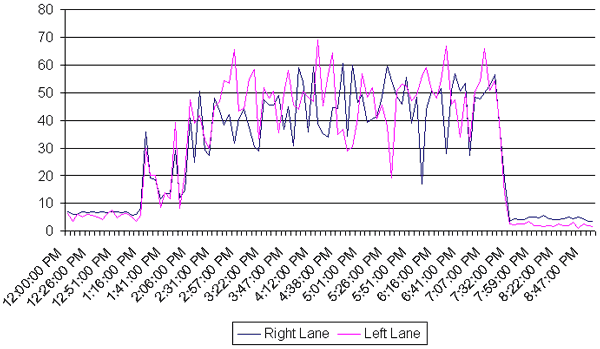
Figure 9. Occupancy Values (System Q1: I-35 NB) – November 26 Incident (With ITS)
Figure 10 shows trends in ramp volumes during the same period on November 26, 2006. The general trend shows that motorists used the guidance provided by the system and diverted around the impact area.
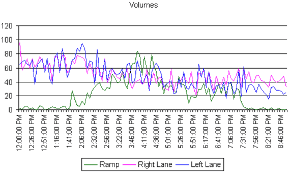
Figure 10. Volumes (Q2: I-35 NB) – November 26 Incident (With ITS)
The study team also analyzed actual diversion levels based on the percentage of traffic using the ramp at each diversion point compared with similar days during the same month. The following table highlights the percentage of traffic that diverted for another incident that occurred on November 23, 2006. While the total volumes varied, the percentage of total volume using the ramp changed significantly when the system advised motorists to divert.
| Date | Detector | Volumes | Percent Diversion | Number of Records | Active Diversion Time Period | |
|---|---|---|---|---|---|---|
| Ramp | Total | |||||
| 11/9/2006 | q01 | 70 | 1479 | 4.7% | 68 | From 10:10 AM to 11:51 AM |
| q02 | 35 | 1409 | 2.5% | 100 | From 10:23 AM to 12:43 PM | |
| q03 | 14 | 1423 | 1.0% | 96 | From 10:20 AM to 11:57 AM | |
| 11/16/2006 | q01 | 113 | 2090 | 5.4% | 98 | From 10:10 AM to 11:51 AM |
| q02 | 61 | 1926 | 3.2% | 137 | From 10:23 AM to 12:43 PM | |
| q03 | 15 | 1305 | 1.1% | 86 | From 10:20 AM to 11:57 AM | |
| 11/23/2006 | q01 | 985 | 3596 | 27.4% | 97 | From 10:10 AM to 11:51 AM |
| q02 | 934 | 3356 | 27.8% | 136 | From 10:23 AM to 12:43 PM | |
| q03 | 383 | 3354 | 11.4% | 96 | From 10:20 AM to 11:57 AM | |
| 11/30/2006 | q01 | 77 | 1328 | 5.8% | 96 | From 10:10 AM to 11:51 AM |
| q02 | 72 | 1463 | 4.9% | 144 | From 10:23 AM to 12:43 PM | |
| q03 | 17 | 1138 | 1.5% | 103 | From 10:20 AM to 11:57 AM | |
The Thanksgiving weekend incident showed a similar pattern, as outlined in Table 10. Similarly, the total mainline traffic volume was significantly higher, but the diversion rates as a percentage of total mainline traffic were also significantly higher. A 27 percent difference in ramp to total traffic occurred compared with other similar days of the week as a result of the alternate route guidance displayed.
| Date | Detector | Volumes | Percent Divert | Number of Records | Time Period | |
|---|---|---|---|---|---|---|
| Ramp | Total | |||||
| 11/5/2006 | q01 | 23 | 558 | 4.1% | 13 | From 5:59 PM to 6:12 PM |
| q02 | 68 | 5735 | 1.2% | 294 | From 2:13 PM to 7:32 PM | |
| q03 | 16 | 3659 | 0.4% | 157 | From 4:12 PM to 6:46 PM | |
| 11/12/2006 | q01 | 15 | 514 | 2.9% | 13 | From 5:59 PM to 6:12 PM |
| q02 | 75 | 5851 | 1.3% | 295 | From 2:13 PM to 7:32 PM | |
| q03 | 28 | 3854 | 0.7% | 157 | From 4:12 PM to 6:46 PM | |
| 11/19/2006 | q01 | 17 | 451 | 3.8% | 12 | From 5:59 PM to 6:12 PM |
| q02 | 74 | 5467 | 1.4% | 298 | From 2:13 PM to 7:32 PM | |
| q03 | 32 | 3301 | 1.0% | 158 | From 4:12 PM to 6:46 PM | |
| 11/26/2006 | q01 | 35 | 482 | 7.3% | 11 | From 5:59 PM to 6:12 PM |
| q02 | 2332 | 8084 | 28.8% | 314 | From 2:13 PM to 7:32 PM | |
| q03 | 966 | 5549 | 17.4% | 166 | From 4:12 PM to 6:46 PM | |
Overall, the study team found 1 to 28 percent reduction in mainline traffic volume (with an average of 10 percent reduction) during congested periods, lessening the demand for restricted mainline capacity. These results are based on 20 observation periods during which the system actively diverted traffic due to congestion from construction or incidents.
No data collection activities occurred on the alternate routes, making it difficult to determine the operational performance of the two- and four-lane alternates during diversion periods. Additionally, due to the limited number of system detectors (two in each direction), the study team was not able to draw meaningful conclusions about how well the diversion rates improved mainline conditions and travel times.
Dynamic Message Sign Data
The system archived message logs from October 2006 until February 2007. The archives included more than 650,000 records. The study team observed some small quantities of missing or anomalous information.
Throughout the deployment, the system posted variations of different messages at different times. On occasion, the system posted a message recommending an alternate route for very short periods followed by a different message. For each approach, the system was consistent in posting a general message on the upstream message board and a more specific message, such as recommending the alternate route, downstream.
The system used several preprogrammed messages, and operators had the ability to override the system and post messages manually as needed. Variations of the following messages were posted at different times throughout the deployment.
Messages Showing Delay
- WORKZONE AHEAD 2 MILES MODERATE DELAYS.
- WORKZONE AHEAD 2 MILES EXPECT DELAYS.
- SLOW TRAFFIC AHEAD MODERATE DELAYS.
- SLOW TRAFFIC AHEAD EXPECT DELAYS.
- ROAD WORK AHEAD 2 MILES MODERATE DELAYS.
- ROAD WORK AHEAD 2 MILES LONG DELAYS.
- ROAD WORK AHEAD 2 MILES EXPECT DELAYS.
Messages Showing No Delay
- WORKZONE AHEAD 2 MILES NO DELAYS.
- TRAVEL TIME X MIN NEXT X MILES.
- ROAD WORK AHEAD 2 MILES NO DELAYS.
Messages Encouraging Diversion
- TRAFFIC STOPPED AHEAD USE ALT IH35 ROUTE.
- TRAFFIC STOPPED AHEAD ALT RTE EXIT 364A.
- ROAD WORK TRAFFIC STOPPED USE ALT ROUTE.
- ALT IH35 EXIT NOW 3 FOLLOW ROUTE MARKERS.
- ALT IH35 EXIT NOW 364A FOLLOW ROUTE MARKERS.
- ALT IH35 EXIT NOW 374 FOLLOW ROUTE MARKERS.
Messages Showing General Traffic Conditions
- SPEED AHEAD X MPH X MIN NEXT X MILES.
- SPEED AHEAD X MPH REDUCE YOUR SPEED.
- SPEED AHEAD X MPH REDUCE SPEED NOW.
- SLOW TRAFFIC AHEAD BE PREPARED TO STOP.
Other Messages
- SLOW ICE WARNING.
- DRIVE SAFELY.
Overall, the system posted consistent messages and, based on the archived data, appeared to function properly. The system provided a benefit to travelers during periods of mainline congestion by providing alternate route recommendations and reducing demand for the mainline freeway.
Tips and Lessons Learned
Deployment Tips and Lessons Learned
The study team uncovered several lessons learned to the benefit of TXDOT and others interested in deploying similar systems.
Begin work on the deployment at the early concept stages of the planning process. The deployment at this site was delayed due to lead time in procuring the system. To achieve the maximum benefit, ITS should be operational prior to any lane restrictions.
In design and implementation of ITS for work zone applications, agencies should involve the construction contractor as early as possible and to the fullest extent possible. TXDOT experienced unanticipated delays in modifying the contract to include the ITS system. Agencies risk not achieving their goals if the system is viewed as a "pass through" to a vendor and not the responsibility of the contractor.
Personnel from the implementing agency should have real-time access to archived system data to identify any issues and monitor system functionality. For the TXDOT site, a Web site provided real-time information display, but archived data access was more time consuming and not easily accessed on short notice.
Evaluation and Research Tips and Lessons Learned
Prioritize and focus on a small number of metrics that provide the best opportunity to quantify benefits. Diversion patterns at this site proved very useful in assessing the response to diversion-based messages.
Previous | Next