
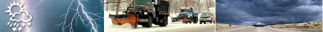
Weather Information System Helps Keep North Dakota Roads Clear
By providing timely, precise information on pavement and weather conditions, an innovative new technology is improving snow and ice removal operations in North Dakota.
The Challenge
When winter storms strike North Dakota, the State Department of Transportation (DOT) faces a range of challenges. "The average annual snowfall for North Dakota is about 45 in (1,125 mm), and the record is about 90 in (2,250 mm). That's not really very much," says Jerry Horner of North Dakota DOT. "But because North Dakota highways span a lot of wide-open areas, we have problems with drifting snow. We also get icing in the early winter and late winter."
After learning about how other States were using road weather information systems (RWIS), a technology evaluated and enhanced under the Strategic Highway Research Program (SHRP), North Dakota DOT decided to install an RWIS.
Putting the Technology to the Test

Over the past several years North Dakota has set up 14 RWIS stations. Four are in the Bismarck area, and two are near Fargo; the others are spread throughout the State, in areas that experience problems with drifting snow and ice. Every highway district has at least one RWIS station.
The RWIS enables North Dakota DOT to keep on top of winter's challenges. "With better information about weather conditions provided by RWIS, supervisors are much more comfortable with their snow maintenance decisions and feel more in control when scheduling crews," says Charlie Kahl, district engineer for North Dakota DOT. "We're able to implement better response strategies."
Data collected by the weather and pavement sensors incorporated into the RWIS allow the DOT to evaluate real-time conditions and send crews when and where they are most needed.
The system is instrumental in helping the DOT to prepare for each storm. For example, an RWIS station about 73 km (45 mi) northwest of Fargo lets the DOT know what type of precipitation—rain, sleet, or snow—is headed for the city; the DOT can then begin to prepare a targeted response. As more States and Canadian Provinces adopt RWIS technologies, highway agencies will be able to share their data, allowing even better responses.
The RWIS also saves the State money, in part by allowing the DOT to use less deicing material. "The system may reduce the need for salt in certain areas, particularly on river crossings and other bridges, where we used to salt like crazy," Kahl says. He reports that reduced use of sand on a bridge on Interstate 94 near Fargo during four storms saved the highway agency an estimated $10,000 to $15,000, more than half the cost of one of the State's RWIS stations.
Finally, RWIS gives North Dakota DOT "very good and timely information on when to impose load restrictions on trucks due to extremely low pavement temperatures," says Horner. Previously, he says, the State had to use a "seat-of-the-pants" approach.
As North Dakota DOT expands its RWIS system, it hopes to provide weather information to work crews via laptop computers and modems, making the data more useful in planning operations.
The Benefits
North Dakota's weather and pavement sensors have several benefits for DOT operations:
- Winter maintenance strategies are more efficient and effective.
- Roads are clearer and safer during the winter.
- Crews can apply deicing materials only when needed, saving money.
- The DOT can determine exactly when to impose load restrictions on trucks in response to extreme cold.
