|
|
| 11.1 Chapter Overview |
The purpose of this chapter is to illustrate various aspects of planning, deploying, and operating ramp metering systems by providing overviews of the experiences of various agencies who have implemented ramp metering and other ramp management strategies in their cities. This is intended to provide the reader with a first-hand example of what has been done around the country, providing practical examples of the best practices highlighted in this manual and lessons learned through the process.
Sections 11.2 through 11.6 present case studies that detail how different jurisdictions have successfully deployed and used ramp management strategies presented in this handbook. Each case study analyzes a particular issue in the project life-cycle process (planning, implementation and operations of ramp management strategies). This allows the reader to obtain the information that is useful in their pursuit of managing ramp traffic. The five case studies highlighted in this chapter include:
- Evaluation and Performance Monitoring (Twin Cities, Minnesota).
- Outreach and Public Information (Washington State).
- Safety and Congestion (Madison, Wisconsin).
- Permanent Ramp Closure (Honolulu, Hawaii).
- A Systematic Approach to Ramp Metering (California).
Chapter 11 Objectives:
- Objective 1: To learn from jurisdictions across the country about various issues in the ramp management project life-cycle.
- Objective 2: To understand the importance and value of an efficient evaluation and performance monitoring program.
- Objective 3: To realize the critical role that information dissemination has in the success of a newly implemented ramp management strategy and how to conduct an effective public information campaign.
- Objective 4: To learn how agencies have implemented ramp management strategies to improve safety and congestion on their corridors and what it takes to accomplish this.
- Objective 5: To understand the issues surrounding a decision to permanently close a ramp and what resources are required to evaluate a potential closure.
- Objective 6: To gain a sense of how an agency can integrate Transportation Management System strategies in a systematic and coordinate fashion which can result in safer and more efficient operations.
|
| 11.2 Evaluation and Performance Monitoring – Twin Cities, Minnesota |
This section highlights the experiences of an agency in implementing an evaluation and performance monitoring effort, using the Minnesota Department of Transportation (Mn/DOT) ramp metering system in the Minneapolis/St. Paul region (also referred to as the Twin Cities) as an example.
The ramp metering application deployed and operated by Mn/DOT in the Twin Cities Metropolitan Region is one of the most extensive applications in the nation. This system of over 430 ramp meters is used for corridor and regional traffic control and has historically employed some of the most restrictive metering algorithms in the nation.
The Twin Cities ramp metering system was also subject to an extensive and well publicized evaluation in 2000 when the meters were turned off for a six-week period for evaluation of the impacts of the application. An extensive planning and policy review effort followed to modify the region’s metering system to better balance the needs of system operators and regional travelers. Many useful lessons learned resulted from this effort involving the evaluation and performance monitoring of mature metering systems.
Specifically, this case study will highlight the evaluation and performance monitoring experience of Mn/DOT by providing answers to the following questions:
- Why was the evaluation and performance monitoring effort undertaken?
- How was the evaluation performed? What data collection and analysis methodologies were employed?
- What were the outcomes of the evaluation effort?
- What continuing performance monitoring efforts have been implemented?
- What are the experienced and expected impacts of the evaluation and performance monitoring effort? (i.e., What has changed as a result of the effort?)
- What resources were required to conduct the evaluation and performance monitoring?
- How has the effort evolved over time?
- What were the significant lessons learned by the agency as a result of this undertaking?
As this case study documents, evaluation and performance monitoring is an important issue that should not be overlooked when planning and operating ramp management strategies. In addition to this case study, Chapter 9 of this handbook provides additional information and guidance on successful evaluation and performance monitoring of various ramp management strategies. |
|
This section provides summary background information of the physical and operating characteristics of the Twin Cities ramp metering system. It should be noted that the planned evolution of the system actually is a decrease in the number of meters. This is because market research studies indicated that travelers perceived their wait times at the ramp meters to be much longer than what they really experienced. In order to improve traveler satisfaction, a number of ramp meters will be removed by 2008. Table 11-1 shows a system summary for the Twin Cities ramp metering system.
Table 11- 1 : Ramp Metering System Summary - Twin Cities, Minnesota
| Characteristic |
|
Number of Meters |
430 |
Freeway Miles |
210 in Twin Cities metropolitan area |
Types of Metering Control Applied |
Mix of pre-timed, traffic responsive, and system wide ramp metering |
Time of Day Operation |
Both AM and PM peak periods |
Planned Expansion of the System |
350 by 2008 |
Special/Unique Applications
or Capabilities |
Represents one of the most comprehensive ramp metering systems in the country. Includes some metering of freeway-to-freeway ramps. |
|
|
| 11.2.2 Institutional Summary |
|
|
This section provides a summary of the institutional characteristics of the Twin Cities ramp metering system which is highlighted in Table 11-2. |
|
This section focuses on the comprehensive evaluation effort conducted to estimate the impacts of the ramp metering system in the Twin Cities. The lessons learned in this effort illustrate the need for system evaluations, both as a tool for further improving the system and measuring the benefits of the system. Further guidance on how to conduct such an evaluation is discussed in Chapter 9. This case study will further explore the subsequent planning effort that was conducted to modify the operating policies and procedures.
Why was the evaluation and performance monitoring effort undertaken?
The evaluation of the ramp metering system was mandated by the State legislature. This mandate was prompted by a small, but vocal, group of citizens who were opposed to ramp metering. The legislature directed Mn/DOT to suspend the operation of the metering system for a six-week period and provided funding for a comprehensive independent evaluation of the impacts observed during the shutdown period to identify the overall impacts of the system. Throughout the shutdown experiment, the evaluation was extensively covered in the local media and followed by the public.
Table 11- 2 : Institutional Summary - Twin Cities, Minnesota
| Characteristic |
|
Managing Agency(ies) |
Minnesota State Department of Transportation (Mn/DOT) |
Year Started |
1969 for first testing |
Goals of Implementing
System |
To optimize freeway safety and efficiency in the metropolitan area |
Implementation Planning Process |
The Mn/DOT system represents a mature ramp metering system that has been deployed and integrated incrementally over more than 30 years. Prior to the evaluation efforts in 2000-2001, ramp metering was automatically implemented as part of all freeway capital improvement projects. Since that time, Mn/DOT has adopted a more performance-based approach, as described in the case study text. |
Evolution of the System |
Steadily added more ramp meters to manage the flow of traffic through bottlenecks and help traffic merge onto freeways. |
Operating Agreements/
Multi-Jurisdictional
Agreements |
Mn/DOT operates the ramp metering system under long standing multi-jurisdictional agreements with local and county agencies that provide Mn/DOT with great latitude in their operational policies. |
Evaluation or Monitoring
Activities Performed |
Periodic performance evaluations were conducted early in the deployment of the system. A comprehensive, legislative-mandated evaluation was conducted in 2000, as described in the case study text. |
|
How was the evaluation performed? What data collection and analysis methodologies were employed?
System performance data was collected during two six-week periods, both preceding and during the ramp metering shutdown. Data collected prior to the shutdown was used to represent travel conditions “with” the ramp metering system. Data collected during the shutdown period was used to reflect “without” the ramp metering system.
Intensive data collection efforts were targeted at four different freeway corridors selected to represent different types of regional freeways: an inner-city corridor, the regional beltway, a radial freeway inside the beltway, and a radial freeway outside the beltway. Each of the representative corridors was subject to traffic volume counts and travel time runs on the freeway mainline and on parallel arterial corridors. Queue delay studies were also conducted at all on-ramp locations.
The conditions of the representative corridors were then compared for the “with” and “without” periods to determine the impact of the metering system on travel volumes and speeds. The results for the representative corridors were then extrapolated to the remaining corridors in the region based on their type.
Safety impacts were analyzed through the use of the incident reporting database maintained by the Minnesota Highway Patrol. The actual number of incidents (by type) was compared for the “with” and “without” period to analyze the change in the number of crashes occurring on freeway and ramp facilities.
An intensive market research study was also conducted in parallel to the impact study. This effort consisted of several rounds of focus groups and telephone surveys, which occurred before, during, and after the metering shutdown period.
What were the outcomes of the evaluation effort?
Several performance measures were used to evaluate the ramp metering system. These included traffic volumes and throughput, travel times, reliability of travel time, safety, emissions, fuel consumption, and public perception. The highlights are shown below.
- Throughput: Traffic volumes on the freeway mainline were observed to decrease by nine percent when the meters were shut down. There was no appreciable change in the volumes on the parallel arterials observed when the meters were shut down.
- Travel Time: Freeway speeds were reduced by 14 percent, or 11.9 km/h (7.4 mi/h), when the meters were shut down, resulting in greater travel times that more than offset the elimination of ramp queue delays. There was no appreciable change in the travel times on the parallel arterials observed when the meters were shut down.
- Travel Time Reliability: Travel times were nearly twice as unpredictable when the meters were shut down.
- Safety: Crashes on freeways and ramp segments increased by 26 percent when the meters were shut down.
- Benefit/Cost Analysis: The ramp metering system was estimated to produce approximately $40 million in benefits to the Twin Cities region. These benefits outweighed the costs of the ramp metering system by a ratio of 15 to 1.
- Market Research: Survey and focus group efforts were used to gather perceptions and opinions on the metering system. This research revealed that the majority of Twin Cities’ residents supported the use of ramp metering and felt that the system provided them with a benefit. However, many residents also supported modifications to the system to decrease time spent waiting in the ramp queues. The market research findings generally supported the observed impacts of increased safety, improved travel time, and more reliable travel times resulting from ramp meter operation. One noted discrepancy involved the time spent waiting in the ramp queues reported by travelers. Travelers perceived their wait times to generally be twice as great as the observed wait times.
What continuing performance monitoring efforts have been implemented?
The ramp meter shutdown experiment involved the collection of a large set of performance data. This observed data was compared with data generated by the Twin Cities comprehensive traffic detection systems and was found to validate the data automatically generated by these systems. In subsequent evaluation efforts and in continuing system monitoring activities, this automated data has been utilized to a great extent. In conducting the experiment, Mn/DOT also became better aware of the benefits of performance evaluation, monitoring, and reporting. In several recent implementations of operational improvements or modifications, Mn/DOT has included an evaluation component as well as public outreach and education efforts to ensure that the public is aware and understands the benefits of the implementations.
What are the experienced and expected impacts of the evaluation and performance monitoring effort? (i.e., What has changed as a result of the effort?)
Although the evaluation found that the ramp metering system provided benefits that far exceeded its costs and the market research indicated that a majority of travelers supported the use of ramp metering, some modifications were implemented to reduce reported dissatisfaction with the wait time required in the ramp queues. Several policy and operations changes were made, including implementing less restrictive algorithms, decreasing the hours of operation, and deactivating several meter locations. A subsequent evaluation effort revealed an increase in traveler satisfaction as a result of the modifications.
What resources were required to conduct the evaluation and performance monitoring?
The legislative action mandated that an independent contractor be responsible for the evaluation. Mn/DOT contracted with an outside consulting team for approximately $650,000 to conduct the evaluation. Additional internal Mn/DOT resources were required to provide project management, public communication, and various data assembly tasks.
How has the effort evolved over time?
Following the ramp meter shutdown experiment, modifications were implemented impacting meter policy and operation in the region. A subsequent evaluation effort was conducted, utilizing another round of market research activities and system performance analysis. In this subsequent evaluation, automated data sources were used to a much greater extent to reduce data collection costs. Comparisons of the data revealed that the implemented modifications resulted in slightly reduced travel time and safety benefits; however, a greater majority of residents approved of the modified system.
What were the significant lessons learned by the agency as a result of this undertaking?
Prior to the evaluation being mandated by the legislature, the ramp metering system had been implemented and expanded in the region with limited formal assessment of the impacts. While it was assumed that the system produced significant operational benefits for the region’s freeways, there was little empirical evidence to justify the system when opponents questioned the benefits. The shutdown experiment provided a unique opportunity to test the impacts of a mature ramp metering system. Following the experiment, Mn/DOT better recognized the value of performance evaluation and monitoring and implemented more formalized efforts to perform these functions.
The impacts observed during the experiment supported Mn/DOT’s assertions that the system provided substantial benefits; however, the market research effort revealed that many residents were dissatisfied with certain operational aspects of the system, and did not necessarily understand the tradeoff between more restrictive metering and improved freeway performance. Through these findings, Mn/DOT became more aware of the importance of public information and education campaigns in promoting the operation of ramp meters. The result of the evaluation was the implementation of modifications to achieve a better balance of the operational efficiency of the system with the perceptions of travelers. This effort was combined with an increased focus on public outreach to promote the benefits of the system. |
| |
| 11.3 Outreach and Public Information – Washington State DOT |
This section discusses one agency’s efforts to provide outreach and public information on their ramp metering system. This case study focuses on the outreach efforts of the Washington State DOT (WSDOT) in the Seattle region.
The Seattle region’s ramp metering system, operated by WSDOT, provides an example of a mid-sized system that is currently focused on several high-priority corridors. Several recent planning and evaluation efforts have been undertaken to analyze the current performance of the system and plan for expansion of metering to additional locations. To support the planned enhancement and expansion of the system, WSDOT has undertaken a robust outreach and public information campaign.
WSDOT has done an outstanding job with regard to dissemination of information to the public about their ramp management system. This case study will summarize these outreach efforts by providing answers to the following questions:
- What were WSDOT’s objectives in undertaking the vigorous outreach and public information campaign (i.e., What did they hope to gain?)
- How was the outreach and public information campaign implemented? What resources were required?
- What are the experienced and expected benefits of the effort?
- What aspects of the campaign worked well?
- What aspects of the campaign failed to achieve their objectives?
- How has the effort evolved over time?
- What were the significant lessons learned by the agency as a result of this undertaking?
As discussed in this case study, getting detailed information to the public plays a critical role in the success of a newly implemented ramp management strategy. Chapter 7 in this handbook provides additional information on the public information and outreach process of implementing ramp management strategies and plans. |
|
Table 11-3 summarizes the physical and operating characteristics of the Seattle area ramp metering system.
Table 11-
3 : System Summary – Seattle, Washington
| Characteristic |
|
Number of Meters |
120 in 2002 |
Freeway Miles |
760 miles |
Types of Strategies/
Algorithms Applied |
System-wide, Traffic Responsive Control/Fuzzy Logic Algorithm [1] |
Time of Day Operation |
6-10 AM and 3-7 PM weekdays, and other times during incidents and special events |
Planned Expansion of the System |
160 by 2008 |
Special/Unique Applications
or Capabilities |
Some ramp meters in the future will provide preemption for emergency vehicles and priority for transit vehicles. |
|
|
| 11.3.2 Institutional Summary |
|
|
Table 11-4 summarizes the institutional characteristics of WSDOT’s ramp metering system.
Table 11-
4 : Institutional Summary - Seattle, Washington
Characteristic |
|
Managing Agency(ies) |
Washington State Department of Transportation (WSDOT) |
Year Started |
1981 |
Goals of Implementing
System |
Reduce freeway delay and improve travel time |
Implementation Planning Process |
The WSDOT ramp metering system went through the normal design and environmental processes typical of any construction project when initially implemented. There was also extensive public outreach. |
Evolution of the System |
In 1981, 22 ramps were metered. Slow expansion occurred in the 1980’s with major expansions occurring throughout the 1990’s. |
Operating Agreements/
Multi-Jurisdictional
Agreements |
With inter-local agreements: King County Metro Transit, Community Transit - Snohomish |
Evaluation or Monitoring
Activities Performed |
On-going evaluation and monitoring |
|
|
|
This section summarizes the lessons learned from the on-going outreach and public information efforts in the Seattle region. WSDOT gained a great deal of knowledge after the initial I-5 Surveillance/Control and Driver Information (SC&DI) system and HOV lane implementation. When they expanded their ramp metering system for I-90, the process went much smoother and with great success. The following will describe how WSDOT developed their successful public information program.
What were WSDOT’s objectives in undertaking the vigorous outreach and public information campaign? i.e., What did they hope to gain?
In December 1979, a private consultant was hired to conduct focus group discussions concerning the awareness of and attitudes toward the I-5 traffic management systems. One of the key findings was that there was little public awareness of either the planned SC&DI program or the HOV lanes. However, because construction was already evident, participants were angered when they learned about the planned traffic systems after the fact. More than any other idea, the need to inform and educate the public about these programs dominated the discussion.[1]
Based on input at these focus group discussions, the following is an excerpt of what was suggested to WSDOT for consideration:
- Create an awareness program for the introduction of the SC&DI system and HOV lanes using all traditional media, such as television, radio, newspapers, and magazines.
- Work with local groups to provide information and obtain feedback through public workshops sponsored by community clubs, chambers of commerce, service organizations, and other groups.
- Prepare informational materials for public distribution using newsletters, brochures, and newspaper and magazine articles stressing the benefits of the system.
- Provide an ongoing program of education and information.
- Set up an intensive program with employers to enlist their support of these new systems.
- Develop a program for monitoring the effectiveness of the new traffic systems.
Many of these suggestions have now been incorporated into WSDOT’s process for implementation of new systems. They took the public’s comments to heart and have developed a successful method of gaining public support of their projects. WSDOT has prepared a set of formal guidelines that detail the various levels of effort to initiate a public outreach campaign based upon three conditions: [2]
- Providing ramp metering on an existing non-metered corridor.
- Expanding the ramp metering system within an already metered corridor.
- Adding a meter to a ramp located within an already metered corridor.
When implementing new ramp metering projects, WSDOT prepares three key documents: an evaluation plan, a scoping plan, and a public involvement plan. The evaluation plan measures both the positive and negative impacts of the new system on the traffic flow. The scoping plan describes how other agencies (i.e., city, transit, and county governments) identify potential problems and solutions concerning the new ramp meters. The public involvement plan details the ways that WSDOT can get the public involved in all aspects of the project. All three of these plans are carried through the planning, design, implementation, and operation stages of the ramp metering projects.
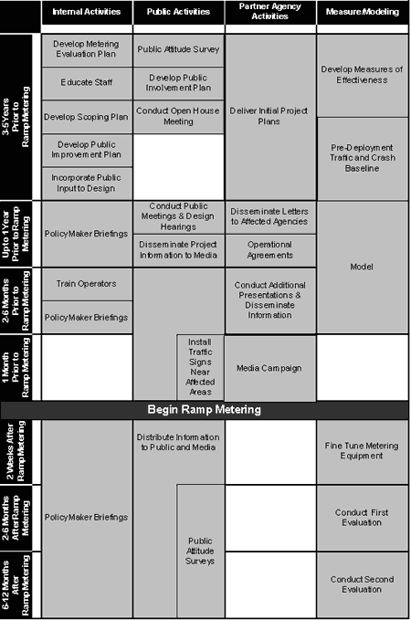
Table 11-5 illustrates all activities that are required by WSDOT for implementation of a ramp metering system, starting from three to five years prior to the meter activation and continuing through one year after activation. For specifics of each of the activities, refer to WSDOT’s SC&DI Implementation and Operations Plan.2
Table 11- 5 : Sample Ramp Metering Implementation Schedule [2]
After learning from the I-5 traffic management system experience, WSDOT now has multiple objectives for their public information efforts: (1) to increase driver education on how to use the ramp metering systems and addresses enforcement issues and (2) to improve driver acceptance through a provision of a comment and design modification period. The second objective allows WSDOT to see if they should change any element of the design prior to construction. For example, motorists are easily able to inform WSDOT of a problem area where the queues back up to the arterial network because they drive the route everyday. WSDOT can then respond by modifying the ramp design to accommodate two lanes of storage, if necessary.
How was the outreach and public information campaign implemented? What resources were required?
One of the campaign elements was the creation of a speaker bureau comprised of WSDOT employees. The bureau was made up of individuals from all departments within WSDOT, including those who were not necessarily in traffic operations or part of the ramp metering group. WSDOT was able to get more resources involved by educating employees about ramp metering so that they each had an understanding of the system, whether or not they lived in the corridor. Then, each person could, in turn, articulate the benefits to the public, other agencies, friends, and family. This type of “inreach” was very effective.
WSDOT also used various forms of media and outreach. Information dissemination took the form of press releases, printed brochures, and website information with frequently asked questions and answers. Professional copy editors and designers prepared the brochures so that they were polished and professional looking. Public forums were held at community meetings, open houses, and shopping malls. The in-house public relations staff handled the public meetings with the assistance of other WSDOT staff. These meetings gave the public a chance to review the plans and ask the staff questions about ramp metering. One innovative technique that WSDOT used at the local shopping mall was to provide entertainment for the children so that the parents could talk to staff uninterrupted.
Another key to the campaign was using a catchy phrase that the public could associate with the ramp metering project. Coupled with this goes the decision as to what the message discusses or focuses on (i.e., safety or congestion improvement message). Figure 11‑1 shows an example of a brochure used for the public outreach campaign.

Figure 11‑1 : I-90 Ramp Meter Brochure
What are the experienced and expected benefits of the effort?
The expected benefits were that the public would have fewer complaints about the new ramp metering system. At the beginning of the I-90 implementation, there were both a high number of driver complaints as motorists were adjusting to the new system. However, there soon was a general acceptance of the ramp metering system. People did not see it as a problem at all. Of course, sometimes there was a ramp meter malfunction that needed immediate corrective action.
Another expected benefit was that motorists would experience travel time savings over the course of their commute. In some cases, motorists found themselves in difficult merges and backups. WSDOT staff corrected the situation and explained the importance of correct metering rates. It was stressed that WSDOT monitors the ramp traffic volumes and queues in order to balance the timing so as not to sacrifice performance of the adjacent arterial streets.
The experienced benefits of ramp metering are as follows: [3]
- Reduction in rear-end and sideswipe collisions by over 30 percent.
- Reduction in freeway mainline congestion of 8.2 percent.
What aspects of the campaign worked well?
WSDOT started the public input process two years ahead of the metering turn-on. This allowed WSDOT staff time to address the public’s design concerns. Who better to solicit input from than the motorists who drive the corridor every day and know the traffic patterns and problem areas? By allowing citizens an opportunity to offer their comments in advance of the design, they can begin to take ownership of the project and feel like a critical part of the stakeholder process.
One of the keys to success in WSDOT’s public information campaign was the holistic approach they took in addressing every facet of the ramp metering project. It was important to address the whole program, including everything from inreach and outreach, press releases, open houses dedicated to the subject, and distribution of printed materials at every possible public event in the corridor. Getting the word out in advance of construction and receiving public feedback was vital. Once the system was up and running, it was equally important to provide the public an opportunity to offer their comments and feedback to make sure that their initial concerns had been addressed. WSDOT posted “FLOW” signs along the corridor directing motorists to call the TMC with any comments about the new system. [4] “FLOW” is the name given to WSDOT’s regional traffic management system, which includes bus/carpool lanes, park-and-ride lots, freeway flyer stops, and the computerized monitoring of traffic flow on the area’s freeways.
How has the effort evolved over time?
WSDOT learned a great deal from the initial I-5 ramp metering effort, which was initiated in 1981. This was the first ramp metering application in the Seattle area and therefore much more work was required than in subsequent expansions. With the addition of ramp meters for the I-90 expansion during the early 1990s, the level of effort was significantly reduced because motorists were already familiar with ramp metering.
WSDOT listens to the public’s concerns and is constantly refining how they handle implementation projects. Their guidelines are “living” documents that are revised whenever necessary.
What were the significant lessons learned by the agency as a result of this undertaking?
The single most important lesson learned was that pre-planning efforts are crucial to the success of the project. An appropriate amount of time must be spent prior to implementation to ensure that the public understands and is part of the development of the project. |
| 11.4 Safety and Congestion – Madison, Wisconsin |
This section discusses the use of ramp meters to mitigate safety and congestion problems in a smaller metropolitan area, using the experiences of the Wisconsin DOT’s (WisDOT) pilot deployment of ramp meters in the Madison region as an example.
In this application, ramp meters were deployed on three interchange locations (five on-ramps) along a four-mile section of the Highway 12 beltline corridor. These ramp meters were deployed as part of a pilot program to specifically address safety and congestion deficiencies in particular locations. The Madison ramp meter deployment was subsequently the subject of two separate evaluations which investigated the impacts of the implementation. These evaluations are being used by WisDOT to better understand the effectiveness of the strategy in reducing congestion and safety deficiencies at particular locations. This case study will illustrate the use of ramp meters for this purpose by addressing the following questions:
- What were the characteristics of the locations where ramp metering was applied to mitigate congestion and safety deficiencies?
- Why was metering selected over other strategies as the preferred mitigation method?
- What was the process used in identifying which locations to deploy ramp metering?
- What have been the observed and perceived benefits of the deployment? Has the strategy achieved its goal of mitigating safety and congestion deficiencies?
- What resources were required to plan, deploy, and operate the system?
- What specific challenges were encountered in planning and deploying the ramp meters?
- How has the effort evolved over time? What plans exist for expanding/enhancing the system?
- What were the significant lessons learned by the agency as a result of this undertaking?
The following case study highlights how agencies have implemented ramp management strategies to improve safety and congestion on their corridors. |
|
Table 11-6 provides summary background information of the physical and operating characteristics of the Madison ramp metering system.
Table 11-
6 : Ramp Metering System Summary – Madison, Wisconsin
| Characteristic |
|
Number of Meters |
5 |
Freeway Miles |
4 |
Types of Strategies /
Algorithms Applied |
Local, pre-timed control with HOV bypass lanes |
Time of Day Operation |
6:30 to 9:00 AM and
3:00 to 6:00 PM |
Planned Expansion of the System |
Currently under consideration |
|
|
| 11.4.2 Institutional Summary |
|
|
Table 11-7 provides a summary of the institutional characteristics of the Madison ramp metering system. |
|
This section focuses on the recent effort to implement ramp metering in a smaller metropolitan area to address safety and congestion deficiencies. Lessons learned in this effort will be related to practices presented in this manual.
What were the characteristics of the locations where ramp metering was applied to mitigate congestion and safety deficiencies?
During an evaluation of the region’s incident management program, it was noted that segments of the Highway 12 corridor experienced crash levels higher than the State average, and that facility speeds showed significant declines, decreasing from 89 to 24 km/h (55 to 15 mi/h), during peak periods. Three interchanges along this segment of the Highway 12 Beltline were selected for ramp metering: Whitney Way (eastbound ramp), Fish Hatchery Road (two westbound ramps), and Park Street (two westbound ramps). These locations were selected based on crash records analysis and traffic analysis (using a microscopic traffic simulation tool) that indicated that these facilities could be benefited by ramp metering to mitigate the unsafe driving conditions and congestion.
Table 11- 7 : Institutional Summary – Madison, Wisconsin
|
Characteristic |
|
Managing Agency(ies) |
Wisconsin Department of Transportation (WisDOT) |
Year Started |
2001 |
Goals of Implementing System |
Improve safety and congestion levels in a localized area. |
Implementation Planning Process |
Deployed as a pilot project to test the effectiveness of ramp meters. |
Evolution of the System |
The effectiveness of the pilot system is being studied to refine the system and determine the potential for expansion of ramp meters to other locations in the region. |
Operating Agreements / Multi Jurisdictional Agreements |
Pilot program was planned and implemented with the assistance of Dane County, the City of Madison, the Wisconsin State Patrol, and other stakeholders. |
Evaluation or Monitoring Activities Performed |
The system has undergone several evaluations to understand the effectiveness of the meters. |
|
Why was metering selected over other strategies as the preferred mitigation method?
Several alternative strategies were considered, including geometric re-alignment of the interchanges. Ramp metering was selected over the alternative options because metering could be implemented more rapidly and at a fraction of the cost of other alternatives. WisDOT also wanted to use the deployment as a pilot test for analyzing the potential effectiveness of the strategy as a safety and congestion mitigation strategy.
What was the process used to Locate Ramp Meters?
An earlier analysis of the incident management system deployed in the Madison region had identified the corridor as experiencing crashes at a rate exceeding the State average. Many of the local transportation professionals attributed the higher than expected crash rate to the congestion caused by difficult merges at several interchanges in the corridor. A subsequent analysis was performed using the Madison region’s travel demand model to compare the impact of various alternative improvements including geometric improvements and several ramp metering configurations. The findings of this analysis were used to prioritize the implementation of the meters at the deployment locations.
What have been the observed and perceived benefits of the deployment? Has the strategy achieved its goal of mitigating safety and congestion deficiencies?
Two evaluation efforts have been subsequently conducted to assess the performance of the pilot ramp metering deployment. The first evaluation was conducted by University of Wisconsin transportation researchers using before and after field traffic (traffic volumes, travel speeds, and travel time) and crash data, microscopic traffic simulation analysis, stakeholder interviews, and public surveys. The second evaluation was conducted by a transportation consulting company using a combination of the regional travel demand model and the U.S. DOT’s ITS Deployment Analysis System (IDAS) software tool to estimate the impacts and benefits of the ramp meters. Both evaluation efforts found that the ramp metering implementation provided significant benefits and was an effective strategy in reducing congestion and improving safety. Specific findings from the University of Wisconsin study [5] include:
- The number of crashes decreased significantly (50 percent reduction) with ramp meters, particularly during the winter months.
- Most agency personnel reported that the time to clear incidents improved with ramp meters.
- Ramp meters improved freeway mainline average speeds by two to ten percent.
- Speed variability was reduced by 5.5 to 9.2 km/h (3.4 to 5.7 mi/h) with ramp meters.
- Ramp meters increased facility throughput by 29 percent.
- Ramp metering did not cause significant diversion of vehicles from Highway 12 to alternative routes.
- Most drivers obeyed the ramp meters with compliance rates averaging from 85 to 98 percent.
- Public surveys indicated that public acceptance of ramp meters was very high.
Additional findings from the IDAS analysis include:
- The number of crashes was estimated to decline by 36 percent in the areas immediately upstream and downstream of the metered ramps.
- Facility speeds were estimated to increase by three percent with ramp metering.
- Freeway mainline volumes were estimated to increase modestly (1.5 percent) with ramp metering.
What resources were required to plan, deploy, and operate the system?
As part of the evaluation, traffic data was analyzed that had been collected before (September 2000 to May 2001) and after ramp meters were activated (September 2001 to April 2002). In addition, researchers reviewed 911 incident reports for crash data, conducted microscopic traffic simulation modeling, and conducted before and after opinion surveys of Dane County drivers. A survey was also conducted of transportation and law enforcement agency personnel, including representatives of Wisconsin State Patrol – District 1, the Madison Police Department, Dane County 911, and Madison Metro Transit.
The ramp metering evaluation was part of a larger study investigating ITS element costs and benefits. The total study cost approximately $175,000, of which the ramp metering evaluation was a portion of this total.
What specific challenges were encountered in planning and deploying the ramp meters?
The most significant challenge in deploying the ramp meters was related to public acceptance. Although many Madison residents were familiar with ramp metering through travel experiences in Milwaukee, Minneapolis, Chicago, and other nearby cities, many other regional travelers were unfamiliar with the concept. The deployment was accompanied by a public education campaign to explain the operation and purpose of ramp metering. Furthermore, public surveys were conducted both before and after implementation to gauge public acceptance and their understanding of the purpose of the ramp meters. Positive driver perceptions on the effectiveness of ramp metering as a strategy for improving travel time and safety ranged from 32 to 64 percent of drivers prior to the implementation. The percentage of positive responses improved following deployment to a range of 78 to 92 percent of drivers.
How has the effort evolved over time? What plans exist for expanding/enhancing the system?
WisDOT is currently using the results from the evaluation efforts to assess the potential of ramp metering expansion in the region. Given the positive performance of the ramp meters and the public acceptance, the expansion of the system to additional high priority interchanges and corridors is expected as funding becomes available.
What were the significant lessons learned by the agency as a result of this undertaking?
The most significant lessons learned upon completion of this effort include:
- The results of the two evaluation efforts have shown ramp metering to be an effective strategy in mitigating congestion and safety issues in isolated locations.
- The improvements to freeway mainline performance were achieved without diverting a significant volume of vehicles to alternative routes.
- The public has been receptive to the use of ramp meters and the deployment has improved perceptions of the strategy as an effective way to reduce congestion, improve travel time, and enhance safety.
|
| 11.5 Permanent Ramp Closure – Honolulu, Hawaii |
This section discusses the issues surrounding the decision to permanently close ramps, using the experience of the State of Hawaii Department of Transportation (HDOT) as an example. The following questions will be addressed for this case study in permanent ramp closures:
- What processes were used to analyze and select the ramps to be closed?
- Were other ramp management strategies considered besides ramp closure?
- What were the results of this ramp closure experiment?
- What parts of the planning process worked particularly well?
- What specific challenges were encountered in planning and closing the ramps?
- What resources were required to plan and implement the ramp closures?
- What were the significant lessons learned by the agency as a result of this undertaking?
- What was the final outcome of this experiment?
This case study describes the issues surrounding a decision to permanently close a ramp and what resources are required to evaluate a potential closure. Ramp closures are also discussed in Chapter 5, Section 5.4.
Not surprisingly, there are very few examples of permanent ramp closures. Often, ramp closure is not considered because many metropolitan areas have already instituted a ramp metering solution. Another reason is that freeway congestion has shifted to the suburban areas where freeway segments are designed for higher speeds and provide ramp access at more distant intervals.[6]
HDOT conducted a two-week ramp closure experiment on the Lunalilo Street on-ramp in the fall of 1997. Figure 11‑2 shows the ramp geometrics. This case study explores the simulated and real-world results of the H-1 freeway on-ramp closure. The H-1 freeway (eastbound and westbound) qualifies as a severely congested facility because central portions of the H-1 operate below 50 km/h (31.1 mi/h) for at least one hour during the AM peak period.5
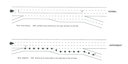
Figure
11‑2 : Ramp Closure Layout for Lunalilo Street On-Ramp
|
|
This section highlights the key issues and lessons learned regarding the HDOT ramp closure experiment.
What processes were used to analyze and select the ramps to be closed?
There were a variety of steps used in the analysis and selection of ramp closure sites. One of the first steps was looking at the ramp closure experiments conducted on Detroit’s Lodge freeway in the early 1960s. These experiments showed considerable improvement in several areas: increase in average freeway speed, decrease in congestion duration, increase in traffic volume serviced on the freeway, decrease in freeway traffic stoppage, and a reduction in the length of the stoppages. [7]
Other urban freeways in North America were evaluated to compare the density of on-ramps with the H-1 freeway. Tabulating forty freeway segments based on the ramp density showed the H-1 westbound ranking as 6th and the H-1 eastbound ranking 11th. It should be noted that the majority of freeway segments that outrank the H-1 are managed with ramp metering. This implies that some sort of freeway management strategy is required for H-1 (metering or ramp closure). Furthermore, a “black spot” analysis was conducted to estimate freeway speeds using average daily traffic (ADT) per lane and the number of ramps per kilometer. The following metric model was used in NCHRP Project 7-13. [8] This simple method (sketch planning tool) provided a good indication of segments where some freeway management would be required.
SPEED (km/h) = 147.1 – 3.2*(ADT/L) – 4.6*(ACCESS)
where SPEED = average peak hour speed in km/h;
ADT/L = average daily traffic per lane; and
ACCESS = frequency of freeway ramps per kilometer.
Figure 11‑3 : Equation. Freeway Speed.
Several simulations and data collection efforts were conducted to establish the base case. A freeway simulation software developed by the University of Minnesota for Mn/DOT was used to simulate 10.5 km (6.5 miles) of the westbound H-1 freeway. This served to replicate the existing conditions and select an on-ramp for closure to improve the overall flow of the freeway system. Several simulations were conducted to create a reliable base case condition. In addition, other traffic analysis tools were used to model the traffic diversion in the AM peak period. A simultaneous collection of freeway mainline and ramp traffic volume data was conducted along with closed circuit television (CCTV) cameras at four cross-sections to record the four hours in the AM and PM peak periods. The video footage was then analyzed to create approximate speed profiles.
After the base case condition was accurately modeled, it was a straightforward process to simulate various ramp closure and ramp metering scenarios. Motorists were re-routed, based on the analysis alternatives, using information collected in origin/destination surveys at key on-ramps.
Collectively, using the numerous (over 30) simulated alternatives, discussions with HDOT Traffic staff, helicopter surveillance, and driver experience, it was determined that the Lunalilo Street on-ramp was the source of a major bottleneck. This also confirmed what was identified using the preliminary “black spot” analysis.
Were other ramp management strategies considered besides ramp closure?
Ramp metering was considered for the H-1 corridor. However, since both the mainline and on-ramp traffic volumes were very high, the metering rate would need to have a long cycle, which effectively means closing the ramp since less than 30 percent of the ramp volume would be allowed access. This helps to show that ramp metering would not have been the appropriate solution. In addition, ramp metering would not have been effective given the close proximity of many of the on-ramps.
What were the results of this ramp closure experiment?
The actual results from the experiment were mixed and modest, at best, and did not match the researchers’ and HDOT’s expectations. Figure 11‑4 shows the evolution of speeds across all lanes. This information demonstrates a decrease in average speed at the cross section of the experiment site, which can be attributed to the motorists’ reaction to the coned auxiliary lane. The coning created a type of impedance similar to an incident, instead of a uniform capacity reduction on a given segment.
The auxiliary and right freeway lanes experienced the greatest reduction in average speed. However, at the end of the two weeks, the average travel speeds had recovered to their normal levels. It should be noted that the ‘Normal’ speeds shown are downstream of the bottleneck. Much slower speeds are experienced upstream of the bottleneck under normal conditions. Although only the 7:45 to 8:00 AM period is shown, all 15-minute periods from 6:00 to 10:00 AM showed a similar trend.
The best result was achieved on the last (10th) day of the experiment. A travel time comparison between the last day of the ramp closure experiment and the following Friday showed a 14 and 24 percent improvement (at 7:00 AM and 7:40 AM). Likewise, a fuel consumption comparison on the same dates and times showed a 15 and 28 percent improvement.
The positive impacts of the ramp closure included:
- Though ramp metering would be a less disruptive alternative, it would have required extensive alignment modifications to meet the storage and acceleration requirements. Therefore, using the on-ramp closure was a much more economical solution.
- The geometry of the Lunalilo Street on-ramp was particularly favorable for a ramp closure. This on-ramp extends to become the right lane of the two-lane Vineyard Boulevard off-ramp. This closure re-routes the traffic to a high-design arterial street (Vineyard Boulevard) which reconnects to the freeway further downstream. And the remaining left lane at the Vineyard Boulevard off-ramp was sufficient to allow mainline motorists off the freeway.
- A majority of the freeway motorists (51 percent) found the experiment to be good or very good. Of the motorists who use the Lunalilo Street on-ramp, 25 percent found the experiment to be good or very good, and 23 percent found it neutral.
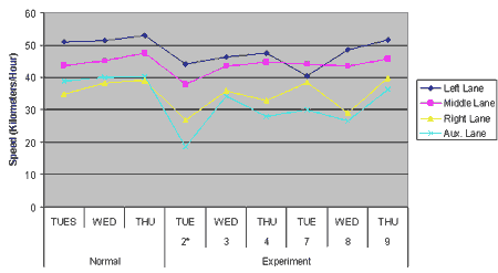
* = Numbers represent the numbered day of the experiment
Figure 11‑4 : Evolution of Speeds Across the Three Freeway Lanes
(7:45 - 8:00 AM)
The negative impacts of the ramp closure included:
- Because the experiment was only two weeks in length, the results were not comprehensive enough.
- Ten percent of freeway motorists rated the experiment bad or very bad. This mostly applied to the drivers who exited early and did not experience the experiment site and therefore perceived longer travel times.
- Fifty-two percent of the Lunalilo Street on-ramp users found the experiment to be bad or very bad.
- Motorists who exited at or past the experiment site gave consistently higher ratings than those who exited earlier. It is clear that the motorists who exited early and did not experience the experiment site perceived longer travel times.
What parts of the planning process worked particularly well?
This demonstration project showed how effectively the two agencies (City and County of Honolulu and HDOT) could work to meet the very demanding requirements and project schedule.
What specific challenges were encountered in planning and closing the ramps?
The planning efforts required a tremendous amount of simulation modeling. Several simulations were required to establish a model with reliable flow conditions. This included an extensive effort to obtain origin-destination information to model motorist re-routings. More than thirty alternatives were analyzed in all.
Closing the ramp required a multi-agency effort. Both the City and County of Honolulu and HDOT worked with local police to ensure that the ramp closure went smoothly. These efforts were especially demanding on the City and State DOT staff.
What resources were required to plan and implement the ramp closures?
HDOT was responsible for the volume counts and overall coordination of the demonstration project. The City and County of Honolulu provided the police staff, helicopter use, and CCTV surveillance. Travel time surveys, coning, and use of the portable variable message signs (VMS) was contracted out by HDOT.
The following is a list of the staffing requirements and equipment needed to implement the ramp closure. This, of course, does not include all of the planning efforts prior to the ramp closure implementation.
- Staff and ten vehicles to conduct travel time surveys along seven routes with departures every 30 minutes.
- Traffic cones every three meters.
- Two police officers at the beginning and ending of coning.
- Three portable VMSs (at the beginning and ending of coning, as well as at the signalized intersection that feeds the Lunalilo on-ramp).
- Continuous monitoring and video recording at six locations through freeway and arterial surveillance CCTV cameras.
- Continuous volume data collection at all on-and off-ramps in the corridor.
- Several hours of helicopter surveillance and video recording.
What were the significant lessons learned by the agency as a result of this undertaking?
Though this ramp closure experiment was just two weeks long, there were some notable lessons learned. First, it is possible to conduct a ramp closure experiment on a major interstate freeway. Not only is it doable and safe, but it is also an affordable option to a ramp metering solution which would require considerable alignment changes in this case. Second, while experimentation is a wonderful method to determine the actual results, a short-term project is not able to attain simulated results because equilibrium and normal driving conditions can not be realized in two weeks time. Third, detailed simulations can be an effective representation of existing traffic conditions and future traffic conditions. Lastly, this experiment demonstrated a successful and cooperative multi-agency effort. Both HDOT and the City and County of Honolulu worked well together to meet the extraordinary demands of this short-term project.
What was the final outcome of this experiment?
In August 2004, HDOT started a formal pilot project aimed at easing congestion on the H-1 freeway. They began closing the Lunalilo Street on-ramp to morning weekday commuters from 6:00 to 9:30 AM. This was an attempt to eliminate a dangerous, traffic-slowing weave on the freeway. Commuters were rerouted to the Punchbowl Street on-ramp via Vineyard Boulevard. The State’s preliminary data showed the change was working and has had little effect on area residents. The results were as follows:
- Travel time savings on the H-1 freeway after the project started was 10 minutes.
- The time it took to get from Piikoi Street to the freeway’s Queen Emma Overpass via the Lunalilo Street on-ramp was an average of 9.2 minutes before the demonstration. With the rerouting, the same distance was covered in 4.5 minutes.
- There was no difference in the amount of traffic on the Punahou Street H-1 on-ramp before and during the ramp closure project.
- There was a small increase of traffic on the School Street on-ramp, but the increase was not enough to create congestion around the ramp.
In October 2004, the State decided to extend the Lunalilo Street on-ramp closure project until February 2005 so more data could be collected and community concerns answered. This time extension cost about $250,000, on top of the original $200,000 that was set aside. The State Transportation Director wanted to continue to evaluate the effects of the rerouting on the community, and was expected to send surveyors to some of the traffic congestion areas mentioned by the public. The data collected in the initial pilot was skewed because the project coincided with emergency sewer repairs on Kapiolani Boulevard, which shut down two lanes in either direction and suspended morning contraflow (reversible middle lane) that was typical for this arterial. The new data collected in January 2005 would be free from any such projects, holidays, and winter school vacations. [9]
Surveys handed out to motorists since the change show that 70 percent of the drivers near ‘Ainakoa Avenue in Kahala rated the project very good or good. However, 39 percent of the drivers on Vineyard Boulevard, where the Lunalilo Street traffic has been diverted, said the project was bad or very bad.
Closing the Lunalilo Street on-ramp in the morning rush hour has helped thousands of East Honolulu commuters on H-1 freeway get to work faster, but Makiki residents say they have paid the price for the convenience of others. The State Transportation Director said that the demonstration project closing the on-ramp has been a success, but that a final look at the Makiki concerns must be done before making the ramp closure change permanent. [10]
In Fall 2004, the Lunalilo Street on-ramp closure was made permanent. Since this time HDOT staff have been working with a local engineering firm to implement ways to automate the closure with devices such as retractable/collapsible curtain of delineators and a zipmobile for relocating New Jersey style barriers.[11] |
| 11.6 A Systematic Approach to Ramp Metering – Caltrans |
This section describes efforts to incorporate ramp metering into a coordinated strategy for deploying operational strategies. The case study uses the recent efforts of Caltrans to develop a systematic and integrated deployment strategy as an example.
In September 2002, Caltrans developed their Transportation Management System (TMS) Master Plan, which is intended to serve as a blueprint for deploying and integrating TMS strategies in the State in a systematic and coordination fashion. [12] The TMS strategies include ramp metering, incident management, arterial signal management, traveler information systems, and the associated support elements.
Caltrans is committed to integrating all prior and future TMS investments into a comprehensive plan that delineates the roles and responsibilities of different transportation agencies and stakeholders, identifies the goals and objectives of the overall transportation operations strategy, and lays out a detailed action plan to reach these goals. The overall operations strategy for the state is described in the Transportation Operations Strategy (TOPS) report published in February 2000. The TMS Master Plan is designed to build on the TOPS findings to define the necessary steps to fully enable the strategies discussed in the TOPS report.
The TMS Master Plan lays out the blueprint for safer and more effective operations of the state transportation system, through system management enabled by intelligent infrastructure. It is intended to be the foundation for all future Feasibility Study Reports (FSR), by laying out the critical milestones for harnessing information technology for system management. Moreover, the TMS Master Plan will guide Caltrans as it works with others to realize its vision.
This section will summarize the efforts to develop this plan, focusing on the issues related to ramp metering, including:
- What was the purpose of developing the plan?
- What are the expected benefits of developing and implementing the plan?
- What was the process undertaken to develop the plan?
- What significant challenges were encountered in developing and implementing the plan?
- What specific guidelines were identified to improve the planning and deployment of ramp metering systems?
- What specific guidelines were identified to better integrate ramp metering as part of an overall operations strategy?
- What resources were necessary to develop the plan?
- How is the plan expected to be applied? How is the plan expected to evolve over time?
- What were the significant lessons learned by the agency as a result of this undertaking?
|
|
This section provides summary background information of the physical and operating characteristics of the Caltrans ramp metering system as shown in Table 11-8.
Table 11- 8 : Ramp Metering System Summary – California Statewide
| Characteristic |
|
Number of Meters |
1,000+ meters Statewide |
Freeway Miles |
Approximately 70 percent of urban freeway miles |
Types of Strategies / Algorithms Applied |
Local and system-wide, pre-timed and traffic responsive control |
Time of Day Operation |
Varies by location. Generally peak periods with isolated operation during special events |
Planned Expansion of the System |
Planned expansion to over 1,400 locations Statewide by 2008 |
Special/Unique Applications
or Capabilities |
Variety of applications and strategies Statewide |
|
|
| 11.6.2 Institutional Summary |
|
|
Table 11-9 summarizes the institutional characteristics of the Caltrans ramp metering system.
Table 11- 9 : Institutional Summary – California Statewide
| Characteristic |
|
Managing Agency(ies) |
California Department of Transportation (Caltrans) |
Year Started |
Pre-1970 |
Goals of Implementing
System |
Improve the safety and capacity in freeway merge areas |
Implementation Planning Process |
Has historically varied throughout the State. The project described in this case study was initiated to provide a more consistent planning and implementation process Statewide. |
Evolution of the System |
The system in the State represents a mature system. Processes are being refined to provide a systematic expansion of the system as the needs require. |
Operating Agreements/Multi-Jurisdictional Agreements |
Varies throughout the State |
Evaluation or Monitoring Activities Performed |
Numerous evaluation efforts have been performed in multiple regions. The most recent evaluation effort included an assessment of ramp metering effectiveness when combined with other operational strategies using a traffic simulation model, as described in Section 11.6.3. |
|
|
|
This section focuses on the recent effort conducted to develop systematic guidelines for deploying and operating ramp metering statewide. Lessons learned in this effort will be related to practices presented in this manual.
What was the purpose of developing the plan?
The plan was developed to provide a more systematic process for deploying and integrating a group of operational strategies, known as Transportation Management System (TMS) in the State. The plan provides operational personnel and planners with greater information on the likely benefits of ramp metering, and other strategies, under a variety of operating conditions. The plan is also intended to provide guidelines for identifying locations where the expansion of ramp metering is warranted. This process is intended to help planners better target the correct strategy, or combinations of strategies, according to the specific deficiency that needs to be addressed.
What are the expected benefits of developing and implementing the plan?
It is expected that the plan will provide for greater consistency of ramp metering and TMS operation in the State and will help maximize the benefits from these deployments. The information in the plan is intended to help planners identify where ramp metering is most beneficial and identify opportunities for integrating ramp metering with other strategies to maximize the benefits of the combined systems. In doing so, the plan is expected to allow an improved prioritization of implementation locations, as well as improved estimates of the future expenditures and resources needed to expand and operate the system.
What was the process undertaken to develop the plan?
The first step in developing the TMS plan was the analysis of the likely impacts of the various TMS strategies under a variety of operational conditions. To complete this analysis, a microscopic traffic simulation model was developed using two corridors, representing the I-405 corridor in Southern California and the I-680 corridor in Northern California. Two different corridors were used to test the strategies’ effectiveness under different congestion conditions. A number of scenarios were then developed representing different deployments and varying travel conditions including time-of-day and incident conditions.
Ramp metering types used in the analysis included pre-timed, traffic responsive, and system-wide metering strategies. Each of these strategies was tested with no queue control as well as moderate and aggressive queue control. These strategies were tested, alone and in combination with other strategies, under a variety of conditions. The purpose of this analysis was to identify the likely benefit of the systems under varying operating conditions and to identify which underlying traffic conditions were best improved by different strategies. The outcome of this analysis was the identification of guidelines for deploying ramp meters that identify minimal traffic volumes and conditions that warrant metering implementation at a particular location.
The deployment guidelines were evaluated for locations throughout the State to identify where ramp metering should be expanded based on both the current conditions as well as under future expected conditions. This analysis identified the magnitude of the expansion necessary to provide consistent application of ramp metering strategies throughout the State. This formed the basis for additional benefit/cost comparison of the relative impacts of the system.
What significant challenges were encountered in developing and implementing the plan?
The identification of the likely benefits of different ramp metering strategies was complicated by the sheer number of different combinations of strategies and travel conditions. The need to identify the impacts of these numerous scenarios prevented the use of real-world “before” and “after” studies of impacts of existing ramp metering implementations. Instead, a microscopic traffic simulation model was employed to provide the evaluation team with the flexibility and control over conditions that allowed the meaningful and comparable assessment of impacts.
What specific guidelines were identified to improve the planning and deployment of ramp metering systems?
The guideline identified by the study states that ramp metering should be deployed in urban/suburban locations “where forecasted volume is greater than 1,800 vehicles per hour at the rightmost freeway lane plus on-ramp, and at locations with significant merging problems” (forecasted volumes are generally obtained from regional travel models). Priority should be given to already congested locations whenever possible in coordination with regional and local agencies.
What specific guidelines were identified to better integrate ramp metering as part of an overall operations strategy?
Guidelines similar to the ramp metering deployment guidelines were identified for a number of TMS field elements including vehicle detection, camera surveillance, arterial signal control, changeable message signs (CMS), and other operations strategies. The plan also identifies the likely incremental travel time impacts of combining various combinations of strategies in congested and less congested conditions to provide planners with an enhanced understanding of the likely benefits of integrating various strategies. These are shown in Table 11-10.
What resources were necessary to develop the plan?
The plan was developed by a consultant team at a cost of approximately $200,000 to Caltrans. This cost includes the resources for conducting the analysis of all TMS strategies, including ramp metering. Existing calibrated simulation models were modified for use in the study to reduce the resources needed to perform the analysis. However, a significant effort was still required to add detail to the existing corridor networks and adjust model parameters to provide an accurate analysis of the numerous strategies.
Table 11- 10 : Peak Period Vehicle Hours Traveled (VHT) Impacts - Combinations of TMS under Incident Conditions
| Year 2010 Simulation Scenarios |
I-680 |
I-405/I-5 |
Existing Incident Management
(26 minutes*) |
0% |
0% |
Add Traveler Information |
-4% |
-3% |
Add Traveler Information + Adaptive
Arterial Signal Control |
-2% |
-5% |
Add Traveler Information + Simple
Adaptive [N] Ramp Metering with Aggressive Queue Control (QC) |
-10% |
-6% |
Add Traveler Information + Adaptive
Arterial Signal Control + Simple Adaptive Ramp Metering with Aggressive Queue Control (QC) |
-15% |
-7% |
Add Traveler Information + Adaptive
Arterial Signal Control + Corridor Adaptive [N] Ramp Metering with Aggressive Queue Control (QC) |
-17% |
-6% |
|
* The average incident duration is 26 minutes with multiple incidents using existing Incident Management strategies.
How is the plan expected to be applied? How is the plan expected to evolve over time?
The plan is intended to provide guidelines for practitioners in determining where the deployment of ramp metering and other TMS strategies would be most beneficial. The plan provides additional information for planners analyzing various deployments and aids in the project prioritization process. Although no formal update process has been implemented, these guidelines may be periodically modified as more information becomes available and the different strategies evolve. The plan also included an effort to detail the planned expansion of TMS strategies in the State and provide estimates of the likely costs and benefits of these deployments. Recent changes in the State’s budget resources have resulted in significant changes in these plans, and the implementation of this portion of the plan was suspended pending future funding increases.
What were the significant lessons learned by the agency as a result of this undertaking?
There were five specific lessons learned that are worth noting:
- Implementation of ramp metering on previously un-metered, congested corridors provided some of the most significant benefits of all the strategies tested.
- Travel time saving benefits of ramp metering were higher in more congested corridors.
- In general, the more sophisticated technologies and strategies brought about greater benefits.
- A comparison of the benefits and costs of upgrading ramp meters in a corridor from traffic responsive to a system-wide metering strategy indicated that the incremental benefits typically do not justify the added expense of system detection needed to operate the system. Therefore, unless the added detection capabilities can also be shared with other strategies (e.g., incident detection), simple adaptive (e.g., local, traffic responsive) deployments should not be upgraded to corridor adaptive (e.g., system-wide traffic responsive).
- Scenarios tested with moderate queue control provided greater time savings benefits than those scenarios using aggressive queue control.
|
| References |
1. Browne, Carolyn. Focus Group Discussions Concerning Awareness of and Attitudes toward I-5 Traffic Management Systems. December 1979.
2. Surveillance, Control and Driver Information (SC&DI) Implementation and Operations Plan. Washington State Department of Transportation, Traffic Systems Management Center. September 1998.
3. Taylor, Cynthia, and Deirdre Meldrum. Evaluation of a Fuzzy Logic Ramp Metering Algorithm: A Comparative Study Between Three Ramp Metering Algorithms Used in the Greater Seattle Area. Available: http://www.wsdot.wa.gov/regions/northwest/traffic/tsmc/RampMeters/eval_report.pdf.
4. I-5 Flow System, Information Packet. Washington State Department of Transportation, District 1. September 1980.
5. Beltline Ramp Meter Pilot Project Evaluation Report -- Executive Summary. Prepared for Wisconsin Department of Transportation. University of Wisconsin. May 2003.
6. Prevedouros, Panos. H-1 Freeway Ramp Closure: Simulation and Real-world Experiment. July 24, 1998.
7. Gervais, E.F. and W. Roth. An Evaluation of Freeway Ramp Closure. Traffic Division, Michigan State Highway Department. 1966.
8. Lomax, T.J., S.M. Turner and G. Shunk. Quantifying Congestion. NCHRP Report 398. TRB, National Research Council, Washington, D.C. 1997.
9. Vorsino, Mary. “State extends Lunalilo ramp closure project.” Honolulu Star-Bulletin Hawaii News. October 28, 2004. Available: http://starbulletin.com/2004/10/28/news/story5.html.
10. Leidemann, Mike. “State holds off on-ramp action until Makiki poll.” The Honolulu Advertiser, March 17, 2005. Available: http://the.honoluluadvertiser.com/article/2005/Mar/17/ln/ln36p.html.
11. Prevedouros, Panos. E-mail. February 13, 2006. pdp@hawaii.edu
12. Caltrans Transportation Management System Master Plan, Financial Plan Report. Cambridge Systematics, Inc. in association with System Metrics Group. September 2002.
General:
U.S. DOT ITS Deployment Tracking Web Site. Available: http://itsdeployment2.ed.ornl.gov/its2002/default.asp
Manual on Uniform Traffic Control Devices. 2003 Edition with Revision No. 1 Incorporated, dated November 2004. FHWA, U.S. Department of Transportation. Available: http://mutcd.fhwa.dot.gov
Mn/DOT Ramp Meter Evaluation -- Phase II Evaluation Report. Prepared for Minnesota Department of Transportation. Cambridge Systematics, Inc. May 2002.
Development of Methods for Benefits Assessment of ITS Deployment in Wisconsin. Final Report No. 0092-02-16, Appendix C - Case Studies. Prepared for Wisconsin Department of Transportation. Cambridge Systematics, Inc. July 2004.
Twin Cities Ramp Meter Evaluation -- Final Report. Prepared for Minnesota Department of Transportation. Cambridge Systematics, Inc. February 2001.
Return to Chapter 1 |
|
|
|
 |
|